The journey continues…and finally comes to an end. There’s no place like home.
On Sunday, I woke at the usual time, made coffee in the little coffee maker, and started packing. Since I’d never really unpacked, I started by doing that. After all, I had at least three hours before I’d be able to leave. I had to do something with that time.
So I packed and watched the Weather Channel. They were forecasting clear skies and light winds for the southwest. Sounded good to me. Local temperatures were around freezing and winds were 5 to 10 miles per hour. The FBO, which I’d called the day before, didn’t open until 8:00 AM. I planned to be there when it opened. I wanted to be in the air by 9:00 at the latest.
I took a long, hot shower and dressed in clothes that were of questionable cleanliness. I’d been smart enough to wash all my clothes at Liz’s house three days before, but I was on my last pair of underwear and I’d only brought three longsleeved shirts along. Fortunately, I had plenty of socks.
I called the taxi company at 7:10 AM and woke up the cab driver. I asked him to pick me up at 7:45 for a trip to the airport. Then I gathered up my belongings and went downstairs to check out.
I left my luggage in lobby and went across the street to get a large latte and roll at a bakery there. I still had my headache and my stomach wasn’t feeling quite right. Migraine, I knew. But I couldn’t take my regular collection of painkillers when I was going to fly so I had to deal with it. I certainly felt okay to fly: alert and eager to be on my way. This headache wasn’t going to stop me.
The cab driver arrived in a van. He was wearing a short-sleeved shirt and was shivering. The van hadn’t warmed up yet and it was freezing outside. He claimed to have forgotten his jacket. How someone can forget to bring a jacket outside when it’s freezing is a mystery to me.
At the FBO, things were warm inside. One of the two women who had been there on Friday was already there. I went with the line guy on duty to retrieve Three-Niner-Lima from the hangar. We pulled it out onto the ramp and I started my preflight while he went to get the fuel truck. Everything looked fine, although I did need to add oil. I loaded my luggage and set up my iPod. I put my bottle of water where I could reach it. I organized my charts. Then I went back to the FBO office with the line man to settle my bill. Fuel was $3.49 a gallon there — that’s $1.10 per gallon higher than Wickenburg. The bottle of oil I bought to replace my empty was $6.50. And the hangar was $50 a night, although she only charged me $50. Between the hotel stay and the FBO charges, Mammoth had not been a cheap stopover. But I’d take it over Rosamond any time.
The line man gave me another lift to Three-Niner-Lima. I told him that if I wasn’t gone in 30 minutes, I probably would be staying for the day. I checked the fuel caps again, climbed in, and buckled up. Although the hangar had been heated, the thermostat had not been set to 68°. The ship was still cold. I gave it two pumps of the primer, then started it up. It ran extremely rough and I think carburetor ice was the culprit. I pulled the carb heat level to full and, as the engine began to warm, some of that warm air made it into the carburetor. It smoothed out. I settled back to wait as the ship warmed up.
A twin taxied past me, to the end of runway 09. By the time I was ready to go, he still hadn’t departed. He finally made a call, then took off. When he passed my position, I picked up into a hover, adjusted the carb heat to full again, made my call, and took off after him.
My the first half of my first leg would be easy. I’d follow the highway — route 395 — southeast, past the towns (and airports) of Bishop, Independence, and Lone Pine. This route was in a deep valley with elevations dropping from 7128 at Mammoth to 4120 at Bishop and 3680 at Lone Pine. The Owens River and an aqueduct ran to the east of the road. The Sierra Nevada Mountains ran along the west side of my path and the Inyo Range ran along the east. Both ranges were snowcapped and beautiful, especially in the early morning sun.
The day was clear and the winds were calm. It was perfect flying weather, except for the cold. At one point, my outside air temperature (OAT) gauge read -2°C. The cabin stayed pretty warm, though, with the morning sun shining into the bubble. I was wearing my baseball cap, to keep the sun out of my eyes.
Other than the mountains and the river beside me, the only other point of interest I passed on that first part of the trip was an array of radio telescopes, or “telescope antennas,” as they were identified on my sectional chart, south of Bishop. Although they were east of my route, I swung over to take a look — and a photo — without getting close enough to affect them.

An array of radio telescopes in the Owens Valley.
The airports along the way were pretty much dead. Bishop, which I didn’t fly directly over, had three runways; it must have been a busy place at one time. The choice of runways probably made it a favorite alternate for pilots who feared Mammoth’s crosswinds. Independence and Lone Pine were nothing more than paved strips. I passed another closed runway along the way and I wondered how long before there were big Xs over the runways at Independence and Lone Pine.
At Lone Pine and Owens Lake (mostly dry), my route got a little tricker. I had to head east, crossing the ends of several mountain ranges, to get into Death Valley. There were a few roads that went my way, but I couldn’t follow just one of them. The trouble with following roads from the air is that you can’t read the road signs. That makes it very easy to take the wrong road when you have a choice. Although some roads appear on a sectional chart, my GPS doesn’t show roads. So to navigate, I need to closely follow my path on the chart while relying on my GPS to point me in the right direction for the next waypoint, keeping in mind that I probably won’t be going on a straight line.
Owens Lake. The reflections of the mountains in the calm water (where there was water) were beautiful.
Why not a straight line? Well, in this case, the darn mountains were in the way. When you’re cruising along in a valley at 500 feet AGL, climbing over mountains just to follow the shortest path isn’t always practical. For example, if I were flying at 4000 feet MSL and I needed to go over a 7000 foot mountain (which meant a climb to 7500 feet or thereabouts), I’d have to climb. My best climb speed is about 60 knots, so I’d have to slow down. Say I could climb at 500 feet per minute at 60 knots. It would take me 7 minutes at that speed to reach the elevation I needed to cross the mountains. Up there, I could be subjected to higher winds and mountain waves (caused when winds cross over mountains and mountain ranges). But if there were a mountain pass just a few miles away, I could detour and slip through that, without climbing as much or dropping speed. While the detour might still take longer, it wouldn’t take much longer and it might be a more comfortable ride.
That’s my take on it, anyway. Other helicopter pilots might have different opinions. Airplane pilots can’t understand this argument at all, since they’re already flying at 10,000 or more feet to go from point A to point B. (They’re also not admiring radio telescopes in the desert and flocks of birds over lakes.) On this part of my journey, I also had to switch from the San Francisco sectional chart to the Las Vegas sectional chart, which I’d borrowed from Rod (mine was in my ship when I was doing my flight planning). Switching charts always makes life interesting, when you’ve only got one hand to do any kind of work. But since my charts had been prepared before I left, it wasn’t so bad.
I headed east at Owens Lake, crossing the mountains in the gap between the Inyo and Coso Ranges. I entered the boundaries of Death Valley National Park and followed a road to Panamint Springs. There wasn’t much going on there, but I did notice a few vehicles, including a motorhome, parked on an overlook for the valley I’d have to cross. I wondered what they thought of the tiny helicopter making its way eastbound.
I followed a road across the dry lake bed at the northernmost end of the long valley, marveling at the sand dunes to my left, which were clearly marked on my chart. The road turned northeast and climbed into a pass of the Panamint Range.
Telescope Peak, which rises over 11,000 feet from the desert floor, was snowcapped and looking beautiful in the midday light.
I followed the road down to Stovepipe Wells, which has a tiny paved strip walking distance from a store, motel, and campground. I’d flown there in May, on my trip to Death Valley, and had regretted it. It was a long walk to the store for a Gatorade and a long walk back to my helicopter.
I was now in Death Valley proper. I headed southeast around the end of the mountain range and zeroed in on Furnace Creek. As usual, it took me a few moments to actually see the airport. Imagine the floor of Death Valley as a dry lake bed, which it mostly is. The airport is on the east bank of that lake and, beyond it, are the campgrounds, lodges, and other facilities that tourists visit. There’s even a golf course — the lowest one on earth. I made a few radio calls and got no response, so I just landed at the pumps. My altimeter read -200.
I’d been at Furnace Creek Airport before, so I knew the drill. I left my ship and headed over to a building where I found a house phone, a pay phone, and a restroom. I took care of business in the restroom first, then used the house phone to call the Chevron station. A while later, a white pickup pulled up to the pump with two men on board. They unlocked the pump, unwound the hose, and let me do the filling. I topped off both tanks and they put everything away. A plane flew overhead, landed, then parked while we worked. Then we all climbed into the pickup truck for the mile or so drive to the Chevron station, where I could pay.
After settling my bill with them (20+ gallons at $3.20 a gallon!), I called for a shuttle ride to the Furnace Creek Inn, where I hoped to get a good meal. The driver was friendly. He told me that the park would get very busy on the upcoming Thanksgiving Day weekend. He dropped me off at the Inn and I gave him two dollars for his time.
At the Inn, I was in for a special treat. First of all, you have to realize that the Furnace Creek Inn, which is a historic monument, is also a 4 diamond resort, as rated by AAA. It’s a nice place. It sits on a hillside overlooking the valley and the Panamint Mountains beyond. It has a pool and tennis courts and a very good restaurant.
Furnace Creek Inn.
What I didn’t know was that the restaurant had a Sunday brunch. And my arrival at 11 AM was just in time for it to begin.
I ate curried chicken salad, chilled asparagus, two kinds of caviar, smoked trout, smoked salmon, and seared ahi tuna. I ate osso bucco, risotto, and roast beef au jus. I ate other things that I can’t remember. All while sitting at a window table, overlooking the stark, silent beauty of Death Valley. The view from Furnace Creek Inn.
Sure it was expensive, but so what? You only go around once, and I don’t like to skimp when it comes to eating good food.
By 11:30 AM, I was ready to move on. The same shuttle driver took me back to the airport. I gave him another two bucks. Then I checked the fuel caps and the oil, climbed aboard, started up, and departed to the east.
I followed the main road past the Inn and out of the valley. I climbed with the terrain, about 400 feet per minute. Once outside the Valley, I set my GPS for my next waypoint, Shoshone. I’d cross a lot of empty, lonely desert to get there and, once there, I kept going toward my next waypoint, Jean, NV. Jean featured a pair of runways beside a pair of casinos on I-15. I never quite made it to Jean, though, because I steered too far to the south. When I came out of the Pahrump Valley, I saw Jean about 10 miles north of my position. So I set my GPS for my next waypoint, Bullhead City.
There isn’t much to say about my leg from Death Valley to Bullhead City because it wasn’t very interesting. The terrain was standard southern California/Nevada desert. That meant a lot of mountains and valleys with very little vegetation or signs of civilization. It was odd to see a road in many places and even odder to see a car on it. Not the kind of place you’d want to land if you didn’t have to. Cell phones would not work — no question there. Nights would get cold. It would be a long walk to help. And wildlife would include predators, like coyotes and perhaps mountain lions. Well, maybe not mountain lions, but definitely coyotes.
But when you spend as much time flying in the desert as I do, you get used to the isolation. And you bring along some supplies that might help you if you do need to land in the middle of nowhere. I carry a small green bag filled with emergency supplies. It contains matches, a signal mirror, some water, a space blanket, medicines, first aid supplies, a yellow bandana (sun shade, signal flag, tourniquet, etc., all in one!) a scissor, an extremely high quality all-in-one tool (like a Leatherman, but better), and lots of other goodies. I don’t carry this bag with me on all trips, but I did carry it on this one and I usually carry it when I fly alone and know I’ll be crossing wide expanses of nothingness. Hell, I don’t want them to find me dead with nothing on board that could have helped me.
I’m looking at my charts and noticed something I failed to mention throughout this narrative: the MOAs. MOA stands for Military Operations Area. It’s a place that the government has set aside for its military pilots to practice in. The southwest is full of MOAs. On this particular day, I passed through a bunch of them: Bishop, Owens, Panamint, Shoshone, Turtle, Bagdad 1, and Gladden 1. Each MOA has its own operating hours, altitudes, and controlling agency. When you pass through an MOA within its operating altitude during its operating hours, you run the risk of interfering with a military training exercise.
As a helicopter pilot, I normally fly below operating altitudes of MOAs. For example, the Gladden 1 MOA’s floor is at 7000 feet MSL or 5000 feet AGL, whichever is higher. I fly at 500 AGL, so I technically don’t fly in the MOA’s airspace. But I often see the F-16s from Luke Airforce Base (south of Wickenburg) streaking across the airspace in pairs, occasionally breaking the sound barrier. And I was once “buzzed” by four F-16s as I crossed through the northeastern corner of the Bagdad 1 MOA at a 80 knots, 500 feet up, minding my own business. Talk about a wake-up call!I can’t remember if I read this or saw it on one of the King written test videos, but the advice was to avoid MOAs at all cost. A pilot in the southwest couldn’t do that. If he tried, he’d severely limit where he could fly. The proper thing to do is to contact the controlling agency to see if the MOA is “hot.” If it is, you should stay out of it.
But I didn’t make any calls. I just flew through at 500 AGL, too low to get in anyone’s way. Heck, I have a transponder. They can see me. Besides, it was Sunday and I figured all the pilots would be back at base, watching a football game.
I passed between Searchlight and Kidwell, flew over the northern end of a small mountain range, and saw Lake Mohave before me. I planned on following the lake south to Bullhead City.
As I rounded the bend and crossed the lake, the wind picked up. I looked at my GPS. I had a 20 knot tailwind. Yee-ha! Ride ’em cowgirl!I called Bullhead City tower when I was still 10 miles out. Things were quiet, as usual. That place is always quiet. The controller told me the winds were 25 knots from the north. No fooling. He told me to report one mile north.
I closed the distance to the airport in record time and reported as requested. The controller told me to land direct to the helipads. That would have me landing with a 20+ knot tailwind. Not a chance. I asked to do a left downwind along the river. He told me to proceed as requested. I came down the river and tried to make my base turn short of the Home Depot parking lot, so I wouldn’t overfly it. The wind wouldn’t let me get away with that and blew me right over the lot, sideways, about 200 feet up. Must have given customers in the parking lot a good show. Look at that tiny helicopter, flying sideways. Fine. I pointed into the wind and headed toward the pads. Eventually, I made it, touched down, and shut down.
I called for fuel and they sent a golf cart instead of a fuel truck. Seems I had to go inside to place my fuel order. I told the woman at the desk to top off both tanks. By that time, she was distracted by the arrival of a Citation jet that would probably take on a lot more fuel than I would. I retreated into the bathroom, which was filthy and didn’t have any toilet paper. Fortunately, I had some tissue in my shirt pocket. It was the worst stop I ever made in Bullhead City and I sincerely doubt whether I’ll buy fuel there again.
A while later, at about 3:15 PM local time, I was airborne, on the last leg of my trip. The tailwind stayed with me for most of the flight. It was a direct flight from Bullhead City to Wickenburg, with no intermediate waypoints. I passed east of Grossman Peak (near Lake Havasu) and east of Alamo Lake. I crossed a lot of empty desert. But this was familiar desert, desert I’d flown over dozens of times — if not more.
I started my radio calls to Wickenburg from just north of Alamo Lake, 50 miles out. No response. Again at 40 miles out. No response. Again at 30 miles out. No response. I finally got a response at 20 miles out: Alta giving me the wind speed and direction and unofficial altimeter setting. “Welcome home,” she added.
I touched down in Wickenburg at about 4:30. Thanks to the tailwind, I’d made record time from Bullhead City, which was over 100 nautical miles away.
Mike drove in just as I was shutting down. He helped me offload all my bags, including the bag of apples and mandarin oranges I bought in Placerville for him.
After a week away, it was good to get home.
 I reached Ennis, which Lynn had told me was very touristy. I didn’t really notice that, but I made my turn there, so I may have missed that part of town. I was still on route 287, but it was heading southbound now. After a while, the road joined up with the Madison River, which I followed for quite some time. When I got to the turnoff for Quake Lake, I turned in. Lynn had told me a little about the place and said she’d wanted to see it when she and Ray had driven past. Ray hadn’t been interested at the time, so they’d gone past without stopping. The place was situated in a canyon where the Madison River flows. In the late 1950s, an earthquake had caused a landslide that dumped debris into the river bed. Twenty-eight people had been killed, although I don’t know how. Perhaps they were on the road there? In any case, the natural dam caused by the landslide had created Quake Lake. I read all this on the sign outside the visitor center. It was all I needed to know, so I didn’t go in. I took a picture of the little lake, then got back into the car and continued on the road as it wound alongside it. There were lots of dead trees sticking out of the water. I imagined a heavily forested canyon suddenly filled with water and the slow death of the trees that were submerged.
 I headed into the park, crossing over the border into Wyoming, the eighth state I’d visited so far. My National Parks pass got me in without a fee. (It works at Yellowstone but not Mt. St. Helens? What kind of bull is that?) I took the map and gave it a quick look. My objective was not to visit the park. My objective was to take a nice, scenic ride south toward Salt Lake City. The problem was, it was a Saturday in August. The park was full. And the tourists were of the most annoying variety: drive-through tourists who will stop their car anyplace someone else has stopped, just to take a picture of whatever that other person is taking a picture of. When I wanted to drive slowly, there was someone on my butt. When I wanted to drive faster, there was someone in front of me. When I wanted to stop in a place where no one else was stopped, two or three other cars immediately appeared, spewing occupants armed with cameras to take the same picture I was trying to take. At one point, I reached a traffic jam on a narrow, one-way road as at least 30 cars had stopped to photograph a grizzly bear on the other side of a creek. I was so wigged out by the crowd that I neither stopped nor saw the bear.
 I did see plenty of elk, though. The first herd was right inside the park, grazing along the Madison River. I guess seeing tourists have tamed them, to a certain extent, because some very gutsy tourists were approaching quite close and the elk didn’t seem to care. I also saw a few bison. Most of the bison, as I recall, are on the grassy east side of the park. I was on the west side. I saw four individual animals, each of which were the subject of many tourist photos. But the one that amazed me the most was the one walking alongside the road in a forested area. I think he was lost. But he was walking on the pavement, forcing vehicles to go around him. That, of course, caused a traffic jam because everyone wants the thrill of driving alongside a walking bison. When it was my turn to pass him, I didn’t stop. I just aimed my camera and pushed the button while I kept driving. He was so close that someone sitting in my passenger seat could have reached out and touched him. Although he didn’t seem interested in me (or anyone else), I could imagine what those horns would do to my car’s paint job if he decided he didn’t like the color red. I wondered what he thought of the long line of campers and SUVs and cars filing past him in slow motion. I also wondered where he was going. Probably to the administrative offices to complain about all the traffic and exhaust.
 I took the exit to the Old Faithful Inn, in search of a decent lunch. I got a great parking spot in the shade and got out with my camera. There was a huge crowd of people sitting on benches, facing the Old Faithful Geiser, which was spewing out various amounts of steam to keep them entertained. I tried two places and found a cafeteria and a buffet. I checked out the buffet and was surprised to find that the cafeteria food had looked better (although it didn’t smell better). As I was walking back to my car, Old Faithful let go and I managed to get a bunch of good photos. It was still bubbling water when I left.
 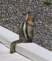 I also managed to get a photo of this little fellow. It’s unfortunate, but people at national parks find it necessary to feed the wildlife. As a result, they become tame, like this guy probably was, and they forget how to forage for themselves. In the winter, when there are fewer tourists around, they starve. That is if they don’t get sick and die from the junk the tourists feed them.
 The road followed the Snake River down to Jackson Lake and Grand Teton National Park. The main feature of Grand Teton is the mountain with the same name, on the southwest side of the lake. It’s 13,770 feet tall, very rocky, and has a glacier not far from the top. In this photo, it’s the mountain that’s farthest away. It was after 3 PM and the sun was moving to the west, making it difficult to get a good photo of the mountains from the east. I followed the road, choosing the path that kept me close to the lake rather than the faster road that went direct to Jackson. A scenic drive.


