A Quick Trip…

…to check for mice.

Our shed at Howard Mesa has been a mouse magnet since we had it installed two years ago. Although we’d ordered it with “hardware cloth” — a wire mesh “fabric” — under the floor, the company that built it for us had neglected to install it. They’d also left lots of places where a small mouse could squeeze in through a crack. Once a mouse gets in, it usually builds a nest in a tucked away place, using bits and pieces of throw rugs, upholstery, curtains, or any other material it can chew to shreds. It also leaves droppings that resemble dark brown pieces of short grain rice every place it’s been. And since mice can apparently climb walls, the mouse droppings can be anywhere.

This was a nightmare for me. Each time we went up to our place for a few days, I’d spend the first four hours cleaning the shed. That included sweeping, vacuuming, washing floors, and disinfecting countertops. Since mice can carry hantavirus, it was especially important that I clear the droppings out without prolonged exposure to them.

I don’t know about you, by my idea of a relaxing weekend away from it all doesn’t include four hours of cleanup.

The Battle

Of course, once I realized that this would be an ongoing problem, I began to wage war against the little critters. I started friendly enough, with mouse traps that would catch them without killing them. I could then transport them to a place far enough away from the shed that they’d take up residence elsewhere.

Of course, I could only set the trap when we were around — if we were gone for a few months, the captive would starve and die a death worse than a quick snap of its neck. But there were enough mice in the place that we usually caught one or two per visit.

When that didn’t seem to be helping, we resorted to rat poison, which we’d throw under the shed before we left. The idea there is that they’d eat the poison and die outside before entering. That was a dismal failure.

Once the shed got electricity — we have a small solar energy system up there — we used a portable inverter to plug in mouse noisemaker devices. They emit a sound that’s supposed to drive mice crazy and keep them away. The constant clicking certainly drives me crazy. We put a few of these annoying things around the shed when we leave. But when we return, it’s pretty obvious that they didn’t keep the mice away at all.

Then we bought weather stripping and used it to seal up the area around the shed’s door. The people who had built the thing had done a pretty shoddy job of it and the door didn’t hang right. The weather stripping would keep out drafts, but would also close up mouse entries. At least that was the idea. Well, it helped the draft problem.

The next task was to locate and close up any exterior hole large enough for a mouse to get in. Evidently, they can get in through some pretty small holes. I took a can of that expanding filler stuff they sell in Home Depot and walked around the outside of the shed with a ladder handy. I poked the tube into every crack and filled it with a dose of the filler. I filled cracks too small to get my finger in. Some were near the ground, some were near the roof, some were around windows. The only thing I didn’t do was go under the shed. But I closed up any holes we’d put in the floor from the inside, so I was covered.

I did all this the last time we were up there, which was for Christmas. We left there on December 27 and hadn’t been back since.

An Upcoming Visit

My dad and his wife are coming for a visit this week. They should be rolling in around noon today. I decided to take them on a helicopter trip up to Lake Powell and Monument Valley, with overnight stays at each place. The flight from Wickenburg to Page pretty much overflies our place at Howard Mesa. And since my dad had never seen it, I thought I’d take the opportunity to show it off.

Of course, during the past few weeks, all I could think about is how much damage the mice could cause in nearly four months on their own. I dreaded the thought of opening the door of the shed to show them the fruits of our hard labor and finding the place destroyed by armies of rodents.

I would be beyond embarrassed.

The only way to prevent this was to take a trip up there and check it out before they came. If it was a mess, I could clean it up before I brought them to see it.

Our Quick Trip

Yesterday morning, Mike and I climbed into Zero-Mike-Lima with a bunch of things we wanted to bring up to the shed — including the cowhide we’d bought at Quartszite in January as a rug for the floor. By about 9 AM we were airborne, heading north.

The morning had been overcast, with a rainstorm moving through the Phoenix area from the southwest. Wickenburg was on the edge of that weather system, so although it smelled like rain, it wasn’t wet. There had probably been some virga overhead. The weather forecast for the Williams, AZ area called for widely scattered rain/show showers until 11 AM, with winds from the south or southwest at about 12 gusting to 17. Although some pilots might have waited until after 11 AM for the flight, I didn’t seen any reason to. The longer we waited, the windier it would get. I didn’t want to be tossed all over the sky on my way up there or back.

Clouds over the WeaversVisibility as we left Wickenburg was fine. There were some low clouds about level with the top of Yarnell Hill. (Mike snapped this picture as we approached; it’s kind of cool because it captured one of the main rotor blades.) We passed just under the clouds as we crossed to the right of Antelope Peak. The flight across Peeples Valley, Kirkland, and Skull Valley was uneventful. When we rounded Granite Mountain — I never fly over the top — we saw the top of Bill Williams Mountain shrouded in clouds. It was hazy up there, but any weather that could cause a problem was to the west, where virga came from the clouds and disappeared about a hundred feet over the desert floor.

Arriving at Howard Mesa, I saw that our windsock had seen its last days. It was torn and hung like a faded orange rag from the pole. The wind was coming from the west, as usual, so I looped around to the northeast and set down on the gravel “helipad” we laid out about two years ago. Mike started unloading the few things we’d brought with us while I shut down the helicopter.

It was cold up there. The temperature was in the 40s, but the wind made it feel a lot colder. I was glad I’d brought my jacket along. We walked up to the door of the shed and I inserted the key. The moment of truth was arriving. I turned the key, turned the door handle, and pulled open the door. The sound of the two mouse noise makers we’d left on could be heard clearly. I looked around quickly — at the floor and countertops — no mouse droppings.

We stepped inside. There were no fresh mouse droppings. The rat poison we’d left was untouched. The place was just as clean as we’d left it.

Mission accomplished. (Really.)

We spent about forty-five minutes tidying up the place, putting down our cowhide rug, and checking water levels in the solar system’s batteries. Then we closed the place up again, hopped back into the helicopter, and headed home by way of Bagdad. (I wanted to show Mike the plane wreck my buddy Ray had shown me earlier in the month, but I couldn’t find it.)

What’s amazing about all this is that it’s a 3 to 3-1/2 hour drive from Wickenburg to Howard Mesa. Each way. By helicopter, it’s about an hour. If we’d driven up to do our mouse check, we would have blown the whole day. But because we flew, we were back home in time for lunch.

The Ups and Downs of Ups and Downs

There’s always one in the crowd.

My company, Flying M Air, did helicopter rides at an airport event in Buckeye, AZ last weekend. I believe it’s called the Buckeye Airport Open House.

The Event

The folks at Buckeye really know how to put on a safe and fun family event. They had a D.J. playing music, classic and experimental aircraft on display and flying by, flight schools, an Army recruiter, fire trucks, a medevac helicopter, a crop-dusting helicopter, and parachute jumpers. They also had a bunch of food vendors and a train to take little kids on rides around the airport.

It was an annual event and this was our third year participating. Although attendance was down a bit this year from last year, we still managed to give about 50 rides, five of which were freebies awarded as raffle prizes.

The Airport staff had set me up on a ramp that connected the main parking area with the taxiway. This was an excellent location because it gave us plenty of space on pavement to operate and made it very easy for us to secure the landing zone. Best of all, it was within view of all attendees, so everyone got a chance to watch me take off and land. (Funny how normal helicopter operations can make their own “air show” for folks who don’t usually get to see helicopters operate.)

They were supposed to have a B-25 parked behind me, but the plane had some engine problems and couldn’t attend. I had mixed feelings about that. On one hand, I was glad that we wouldn’t have to worry about people behind my landing zone. On the other hand, I was disappointed for the attendees, because I knew they’d like to see the plane.

Just Say No to Long Lines

In the past, we’ve always been the busiest “vendor” at the event. During the past two years, I’d continued flying at least an hour after all the other vendors had closed up and gone home, just to work off the line that had formed. I clearly remember flying in at the end of a ride to see eight or ten people waiting in the shade under the wings of a parked aircraft on the ramp. They were waiting for me.

This year, we decided to keep the price the same but shorten up the rides a bit to prevent hour-long lines from forming. Our prices continue to rise — 100LL fuel is now more than $4/gallon at most airports — but we figured that with shorter rides, we’d still come out okay. I liked keeping the price affordable — $35/person — so people could afford to fly and to take their kids. (I always fly a lot of kids at this event.) So I aimed for the low end of our usual 8 to 10 minute flight range. Although actual ride length varied depending on the wind and maneuvers I needed to perform to avoid skydivers and other aircraft, most rides probably came in right around 8 minutes.

It’s important to note here that we never advertised the ride length. It did not appear on any sign. When asked, my ground crew — Mike, Darlene, and Dave — would tell passengers that the ride went out toward the town of Buckeye and came back on a different route. When pressed, Darlene gave out the usual 8 to 10 minute range. None of them were actually timing me. I’d timed the first few rides to make sure I had a suitable route and then stopped timing. I have better things to do when I fly than to watch the chronometer — like making sure the skydivers weren’t going to miss the mark and land on the taxiway in front of me as I approached. The passengers, on the other hand, could easily see how long the rides were by timing them as they waited.

The Route

The flight was a good mix of farmland, new development, and empty desert. I took off, following the taxiway parallel to Runway 17, then headed east toward downtown Phoenix. Early in the morning, it was hazy and the buildings in the distance were impossible to see, but as the sun moved across the sky and the air cleared a bit, details emerged.

We flew over some freshly sown farmland that was being irrigated. In this area, they use gravity to siphon water from a narrow irrigation canal through short lengths of tube that run from the canal to the beginning of deeply cut irrigation rows between rows of crops. The water flows down the rows and, as you fly over it, the sun reflects off its moving surface.

Beyond that, in another field, farm workers were cutting alfalfa. A cutting machine would drive up and down the field, neatly cutting the crop. Then another machine would gather the cuttings into narrow piles of the stuff. A third machine, paired up with a big open-backed truck, would come down the rows, scoop up the cut alfalfa, and dump it into the back of the truck. I found the process fascinating and watched its progress all day. To the south of that, beyond our flight path but still visible, plows worked on another field, sending up clouds of dust that blew back toward the airport in the strong breeze.

Next came a former farm field that had been prepared for a housing development. You could clearly see where the roads and sidewalks and homes would go. But construction had never begun and weeds were growing tall in many areas. Beyond that was a brand new housing development that hadn’t been there the year before. Probably about 200 homes, a school, and a park.

This is where we made our turn to the left, crossing I-10, rounding the east end of a tall hill, and following what I was told was McDowell Road heading west. Now we were over empty desert. Well, empty if you don’t consider the people illegally shooting at makeshift shooting ranges and the incredible amounts of trash dumped out there. We crossed this area with a tailwind, following a fenceline. Ahead of us, in the distance, we could clearly see the Palo Verde nuclear power plant. Below us were a few homes, then more, then more. About two miles from the airport, I’d make my radio call and start scanning the skies for jumpers. I’d turn final for the taxiway parallel to runway 17 and land at the ramp where I was set up for operations.

A Busy Day…and a Crazy Lady

I flew pretty much nonstop from 8:30 AM to 11:30 AM. Then I took a break to use the bathroom and have the helicopter refueled. Buckeye has a 100LL fuel truck, which really takes all the hassles out of refueling. (The first year we did the event, we had to refuel by carrying 5 gallon fuel cans back and forth to the helicopter. What a drag!) I also had a bite to eat. Mike and my ground crew had already sold my next three flights, so I didn’t get a long rest. After 30 minutes out of the helicopter, I was back in my seat, spinning up, getting ready to go.

The event ended at 2 PM and that’s about the same time the other vendors were packed up and gone. I finished flying at about 2:30. We packed up the helicopter, topped off the tanks — I paid for the fuel by check and got an excellent price — and headed home.

That’s when Mike mentioned the “crazy lady” who kept shouting that the rides were only 7 minutes long. I don’t hear anything in the helicopter unless it comes over the radio or intercom, so I had no idea that anyone was giving my ground crew grief. Evidently, her husband and grandson (or maybe son?) had gone on a ride and she’d timed it. According to her, it was only 7 minutes. She claimed that we’d advertised 10 minute rides.

I told Mike that we hadn’t advertised any length for the ride. I asked if she’d bothered anyone else and he said no, she hadn’t. I asked him if anyone else had complained. He told me that everyone else was very happy. And then we just forgot about her. There’s always one malcontent in the crowd and I wasn’t about to let it ruin our day.

The Crazy Lady Makes Herself a Nuisance

I was in Austin yesterday when I checked my voicemail messages from the day before. A Mrs. Smith (not her real name) had called and wanted a call back. She didn’t say what it was about. I called her back and, within a few minutes, realized that I was speaking to the crazy 7-minute lady.

She immediately accused me of ripping off all of my passengers by 1/3 of what they had paid for. Not the best way to start a conversation with me — especially when she was dead wrong.

I told her that the rides were not advertised as 10 minutes and that no one had said they were 10 minutes long. She insisted that that’s the way they had been advertised in the newspaper. I told her that we hadn’t placed any newspaper ads.

She continued along the same vein, repeatedly accusing me of cheating my passengers by three minutes of flight time. She wasn’t interested in the truth. She had this 10 minutes locked in her brain and I couldn’t shake it loose. And the conversation was going nowhere fast.

At one point, she claimed that she had other people to complain to about this but that she thought she’d give me an opportunity to respond first. That sounded like a threat to me. I don’t like threats.

Finally, I said: “What is it that you want from me?”

“Well, you didn’t give your passengers one third of what they paid for –”

More of the same. I cut her off. “I can’t believe you’re wasting your time and mine with this nonsense,” I said. And I hung up the phone.

I don’t know what she wanted from me. Maybe she expected me to give her a refund to keep her quiet. I hadn’t done anything wrong and I wasn’t about to refund money I’d earned. And if she wanted her money back, why hadn’t she asked for it? Did she expect me to offer it? Why would I do that if I’d earned it?

Keep in mind that I’m originally from the New York metro area, where it’s not unusual for people to complain about something in an effort to get it for free. Her threat was a line a New Yorker would use. I wonder how many other times she’d used it successfully on unsuspecting Arizona merchants and vendors who just gave her the money back to shut her up.

Maybe she didn’t realize that she was playing games with the wrong person.

Interview Does Not Equal Advertisement

I was curious about where she’d gotten the 10 minute time from, so I called my contact at Buckeye airport. I told her about the crazy lady and asked if the airport folks had advertised a ride time in the newspaper.

“I didn’t know how long the rides would be,” my contact told me. “So we didn’t put anything specific in the paper. Just helicopter rides.”

“So where did she get this idea?”

“Let me look in the paper.” I heard pages rustling over the phone. Then she came back on. “There’s an article about the event in this week’s paper.”

And she proceeded to read me a section of the article where a couple who had just come off the helicopter was interviewed by the reporter — possibly the same reporter I’d taken for a flight. They used phrases like “once in a lifetime opportunity” and “ten-minute ride” and “highlight of the event.” They were very happy with the ride. (I’ve never had an unhappy passenger.) And I guess that since they didn’t have stopwatches going during their ride, they thought they were in the air for 10 minutes. (Maybe they were. I didn’t time all the rides.) But a report with an interview after the event is a far cry from advertised information.

“Don’t worry about it,” my contact concluded. “There’s always one nut in the crowd.”

We talked about the event and the turnout and how I’d done. “I’d like to come back next year,” I said meekly.

“We want you back,” my contact assured me. “We want you there every year.”

Now I’m wondering what the crazy lady will do next. Because if there’s one thing I know: people crazy enough to make such a fuss over nothing obviously don’t have anything better to do with their time.

Phoenix Sky Harbor to Grand Canyon

I never thought a flight like this would become so routine.

The call came at 9:30 on Friday morning. The voice had a heavy Japanese accent. He wanted to go from Sky Harbor, Phoenix’s busy Class Bravo airport, to Sedona or the Grand Canyon.

“The earliest we can pick you up is 12:00,” I told him. “That’s a little late for the Grand Canyon.”

Flying M Air offers day trips to Sedona and Grand Canyon. The day trip includes roundtrip helicopter transportation following scenic routes, 4 to 5 hours on the ground, ground transportation to Uptown Sedona or into Grand Canyon National Park, and a Sedona red rocks helicopter tour. Grand Canyon is about 45 minutes farther away from Phoenix than Sedona. I’d need to leave either one by about 5:30 PM.

We agreed on a Sedona day trip. I took down his name and weight, his companion’s name and weight, and his credit card information. I’d charge the card before I flew down to get him and he’d sign the receipt when I saw him. Then I hung up and began the process of planning the flight and doing all the paperwork required by the FAA for charter operations. That includes checking weather, creating and filing flight plans, and calculating a weight and balance for each leg of the flight. I do all of it by computer, using Duats for weather and flight planning and my own R44 Manifest form, built with Excel, for the passenger manifest and weight and balance calculations.

By 10 AM, I was done with the paperwork. I changed into more professional clothes, debating whether I should wear a long sleeved or short sleeved shirt. Fortunately, I went with the long sleeved shirt. I packed some hiking shoes and a T-shirt into my day pack, along with my 12″ PowerBook, punched my passengers credit card info into my terminal, and stuck the resulting charge receipt in my shirt pocket. I was ready to go to the airport by 10:30.

At the airport, I did my preflight in the hangar before pulling the helicopter out onto the ramp for fuel. Both Sky Harbor and Sedona tend to have outrageous fuel prices, so I wanted to top off both tanks in Wickenburg. With only two passengers on board, each weighing less than me, weight would not be a problem. By 11:08, I was lifting off from Wickenburg Airport for my passenger pickup point.

Flying into Sky Harbor

These days, most of my big charters are out of the Phoenix area — usually Deer Valley or Scottsdale Airport. Every once in a while, however, I’ll get a charter out of Sky Harbor. Sky Harbor, which lies just southeast of downtown Phoenix, has three parallel runways, with a row of terminals between the north runway and the middle runway. The general aviation FBOs, Cutter and Swift, are on the southwest corner of the field, requiring me to cross arriving or departing airline traffic for my approach or departure.

Sky Harbor, like many towered airports, has a letter of agreement with helicopter pilots called Sharp Delta. Sharp Delta defines terminology and lays down rules for transponder codes and flight altitudes. It used to include instructions and diagrams for landing on the helipad on top of Terminal 3, but that helipad closed down when they began construction on the new tower. I never landed there. I don’t know if it’ll reopen any time soon, but I hope so. It’ll make things a lot easier for my passengers, who have to get transportation to or from Cutter (my FBO choice) to meet me. Cutter has a free shuttle to the terminals, but it adds a step of complexity for passengers who don’t have their own ground transportation.

At first, flying in and out of Sky Harbor was extremely stressful for me. Let’s face it: I fly in and out of Wickenburg, a non-towered airport. I could fly all day long and not have to talk to a tower or controller. The only time I talk to controllers is when I fly into one of the bigger airports in Class Delta, Charlie, or Bravo airspace. And among pilots, there’s this feeling that the controllers at the big airports full of commercial airliners simply don’t want to be bothered by little, general aviation aircraft. We feel a little like recreational baseball players asking the manager of a professional baseball team if we can join them for practice.

Of course, there’s no reason to feel this way. In this country, general aviation aircraft have just as much right to fly in and out of Class Bravo airports like Sky Harbor, O’Hare, LAX, or even JFK as the big jets do. But since those controllers are generally a bit busier than the ones at smaller towered airports, we need to know what we want and where we’re going before requesting entrance into the airspace, be brief and professional with our requests, and follow instructions exactly as they’re given.

The Sharp Delta agreement makes this easy for helicopter pilots flying in and out of Sky Harbor’s space. And, at this point, I’ve done it so many times that it really is routine.

I fly from Wickenburg down to the Metro Center Mall on I-17 and Dunlap. By that time, I’ve already listened to the ATIS recording for Sky Harbor and have dialed in the altimeter setting, which is vital for helicopter operations down there. I wait for a break in the radio action and key my mike: “Phoenix Tower, helicopter Six-Three-Zero-Mike-Lima at Metro Center, Sharp Delta, landing Cutter.”

Phoenix TAC

My usual route.

The tower usually comes back with something like, “Helicopter Six-Three-Zero-Mike-Lima, squawk 0400. Ident.” This means I should turn my transponder to code 0400 and push the Ident button. The Ident button makes my dot on the controller’s radar stand out among all the other dots so he can see exactly which dot I am.

“Zero-Mike-Lima identing,” I reply as I push the button. I don’t know if ident can be used as a verb, but other pilots do it, too.

I keep flying toward the airport, heading southeast toward Central Avenue, waiting for clearance. The controller might give an instruction or two to a big jet landing or taking off. Then he comes back on the radio. “Helicopter Zero-Mike-Lima, radar contact. Proceed via Sharp Delta. Remain west of Central.”

That’s my clearance. He must say either “proceed via Sharp Delta” or “cleared into the Class Bravo airspace” for me to enter the surface airspace for the airport. Because I’m a helicopter using Sharp Delta, I get the Sharp Delta clearance. An airplane or a helicopter not on Sharp Delta would get the other clearance.

I continue toward Central Avenue, the main north/south avenue running down Phoenix. Most of Phoenix’s tall buildings are lined up along this road. I need to stay west of Central and descend down to about 1800 feet MSL (mean sea level). That’s about 600 feet AGL (above ground level). When I’m lined up a block or two west of Central, I turn south and head toward the buildings.

If I have passengers on board, this is usually pretty exciting for them. I have to stay low because of other air traffic, so I’m not much higher than the building rooftops. These days, I have to watch out for cranes for the few buildings under construction downtown. But it gets better. By the time I cross McDowell, I have to be at 1600 feet MSL — that’s only 400 feet off the ground.

Somewhere halfway through Phoenix, the controller calls me again. “Helicopter Zero-Mike-Lima, contact tower on one-one-eight-point-seven.”

I acknowledge and press a button on my cyclic to change to the south tower frequency, which I’ve already put in my radio’s standby. “Phoenix tower, helicopter Zero-Mike-Lima is with you on one-one-eight-point-seven.”

“Helicopter Zero-Mike-Lima, proceed south across the river bottom for landing Cutter.”

I acknowledge. At this point, we’ve crossed the extended centerline for the airport’s north runway, which is less than 5 miles to the east. Commercial airliners are either taking off or landing over us, depending on the wind, which will determine runways in use. I’m always worried about wake turbulence, but it’s really not a problem because we’re so far below.

I cross the extended centerline for the other two runways and approach the bed of the Salt River. It’s usually pretty dry — dams upriver have trapped all the water in five lakes. I’m only about 300 to 400 feet off the ground here and need to keep an eye out for the power lines running along the river. Once across, I turn left and head in toward the airport. I make my approach to the west of Swift, follow the road that runs between the taxiway and the FBOs, and come in to Cutter. They’ve usually heard me on the radio and have a “Follow Me” car to guide me to parking. I follow the car in until it stops and a man jumps out. He uses hand signals that tell me to move up a bit more and then to set down.

That’s all there is to it.

Well, I should mention here that I’m seldom the only helicopter in the area. One of the medevac companies is based at Swift and has two or three helicopters going in and out of there. I also pass a few hospitals with rooftop helipads. And if there’s traffic or an accident or a fire or an arrest going on, there’s usually at least one or two news helicopters moving around. So although I don’t have to worry about other airplanes, the helicopter traffic can be pretty intense.

That’s how it went on Friday. I shut down the helicopter and hitched a ride in a golf cart to the terminal. My passengers were waiting for me: two Japanese men. My contact was probably in his 30s and his companion was possibly in his late 50s. After making sure they both spoke English, I gave them the passenger briefing.

“Can we go to the Grand Canyon instead?” my contact wanted to know. “We really want to see the Grand Canyon.”

I didn’t really want to fly to the Grand Canyon, but there was no reason I couldn’t. Changing the flight plan would be easy enough and I’d already checked the weather for the whole area. I warned him that we wouldn’t have much time on the ground and that we needed to leave by 5:30. I didn’t want to cross any mountains in the dark with passengers on board.

So I did what I needed to do and we departed for the Grand Canyon instead of Sedona.

To the Grand Canyon

I won’t bore you with the details of leaving Sky Harbor. It’s basically the same but backwards. South departure, west until I’m west of Central, then north low-level over the river bottom. They cut me loose when I’m clear to the north.

My two passengers enjoyed the flight through Phoenix, even though they were both seated on the side opposite the best views. (They’d get the good view on the way back.) They both had cameras and were using up pixels with still and video images. We crossed through the west side of Deer Valley’s airspace — with permission, of course — and headed north. I pointed out various things — the Ben Avery shooting range, Lake Pleasant in the distance, the Del Webb Anthem development, Black Canyon City. Once away from the outskirts of Phoenix, I pointed out open range cattle, ponds, roads, and mountains. We saw some wild horses grazing near some cattle in the high desert past Cordes Junction.

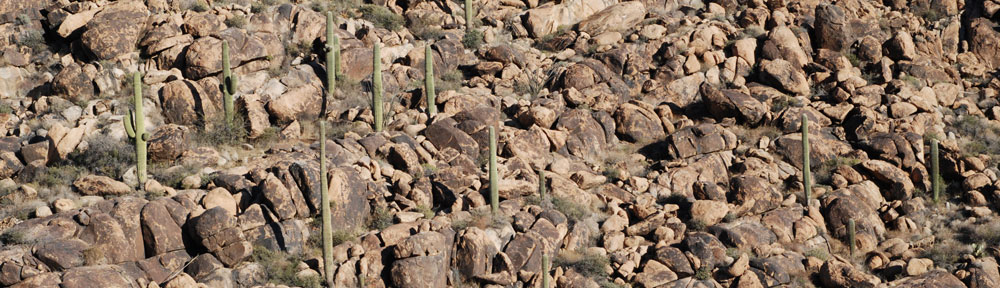
I took them along the east side of Mingus Mountain and showed them the ghost town of Jerome and its open pit copper mine. Sedona was to the east; I told them we’d pass over that on the way back. We climbed steadily, now on a straight line path to Grand Canyon airport, and reached an altitude of over 8,000 feet just east of Bill Williams Mountain. From there, it was a slow descent down to about 7,000 feet. Our path took us right over our place at Howard Mesa, which I pointed out for my passengers, and right over Valle. I called into Grand Canyon tower, and got clearance to land at the transient helipads.

At the Grand Canyon

Once inside the terminal, I asked my passengers if they wanted to go right into the park or take a helicopter overflight. I’m not allowed to fly over at a comfortable altitude, so if my passengers want to overfly, I set them up with Grand Canyon Helicopters or Maverick Helicopters. Both companies fly EC 130 helicopters — the Ecostar — which are much nicer than the old Bell Long Rangers I used to fly for Papillon. I prefer Maverick these days (for mostly personal reasons that I’d prefer not to go into here).

“What do you recommend?” my passenger asked.

“Well, if money is not a concern, I definitely recommend the helicopter flight,” I told him. And that was no lie. Everyone who can should experience a flight over the east side of the Grand Canyon. It’s the longer, more costly tour, but if you don’t mind spending the money, it’s worth every penny.

“Okay,” he said simply.

I didn’t have Maverick’s number on me, so called Grand Canyon Helicopter. A long tour was leaving in 20 minutes. I booked it for two passengers and we walked over to Grand Canyon Helicopter’s terminal.

The helicopter returned from the previous tour and they switched pilots. The woman pilot who climbed on board was the tiny Japanese woman who’d been flying for Grand Canyon Helicopters when I was a pilot a Papillon. I told my passengers what her name was and that they should greet her in Japanese.

Grand Canyon HelicoptersThen they got their safety briefing and were loaded aboard. I took a photo of them taking off. Then I hiked over to Maverick to meet the Chief Pilot there. I had 45 minutes to kill and planned to make the most of it.

I was back at Grand Canyon Helicopters when my passengers’ flight landed. They were all smiles as they got out. I called for transportation into the park and was told it would be 20 minutes. As we waited, the Japanese pilot came into the terminal and spent some time chatting with us. She’s 115 pounds of skilled and experienced turbine helicopter pilot — a dream come true for any helicopter operator. This is her fifth year at the Canyon. They call her their “secret weapon.” When the van pulled up, she bowed politely to my passengers, saying something to them in Japanese. I think they really liked getting a reminder of home so far away.

We took the van into the park and were let off at El Tovar. It was 3:20 PM. I told my passengers to meet me back there at 5 PM. It wasn’t nearly as much time as I like my passengers to have, but our late start had really limited our time. I left them to wander the historic buildings and rim trail on their own and went to find myself something to eat. I hadn’t eaten a thing all day and was starved.

What’s weird about this particular trip to the Canyon is that I don’t think I spent more than 5 minutes looking into the canyon from the Rim. I didn’t take a single picture. This is why the word routine comes to mind. It’s almost as if the Grand Canyon had ceased being a special place. A visit like this was routine. It was something I’d do again and again. If I didn’t spend much time taking in the view this trip, I could do it on my next trip. I think that’s what was going on in the back of my mind.

The time went by quickly. I had lunch, browsed around Hopi House, and took a seat on El Tovar’s porch to wait for my passengers. I was lucky that it was a nice day — I didn’t have a jacket. Several people told me it had snowed the day before and there had been snow on the ground just that morning. But by the time we got there, all the snow was gone and it was a very pleasant day. Not even very windy, which is unusual for the spring. But as the sun descended, it got cool out on the porch. I was glad when my passengers showed up just on time.

I called for the van and was told it would take 20 minutes. That’s the big drawback to taking people to the Canyon — ground transportation. I’d rent a car if there was a car there to rent. But there isn’t, so we’re at the mercy of the Grand Canyon Transportation desk. The fare isn’t bad — $5 per person, kids under 12 free — but the service is painfully slow, especially during the off season. It’s about a 15-minute drive from Grand Canyon Village to the Airport in Tusayan, but between the wait and the slow drivers, it stretches out to 30 to 45 minutes. That’s time taken away from my passengers’ day at the canyon.

Back to Sky Harbor via Sedona

We were in the helicopter and ready to leave the Grand Canyon Airport at 5:45 PM. At that time of day, the airport was dead. Tour operators have a curfew and cannot fly over the canyon past 5 PM this time of year; that changes to 6 PM in May. So there wasn’t anyone around. Fortunately, the terminal was still unlocked with people working at the Grand Canyon Airlines desk when we arrived so we had access to the ramp.

I’d put in a fuel order before we left earlier, so both tanks were topped off. We warmed up and I took off to the south. I set the GPS with a Sedona GoTo and the direct path took us southeast, past Red Butte, east of Howard Mesa. We saw a huge herd of antelope — at least 50 to 100 of them! — in an open meadow about 10 miles north of I-40. It was the same meadow I’d seen antelope before.

We climbed with the gently rising terrain. The forest ended abruptly and I followed a canyon east and then south, descending at 1000 feet per minute into the Sedona area. The low-lying sun cast a beautiful reddish light on Sedona’s already red rocks. The view was breathtaking. My passengers captured it all with their cameras.

We flew through Oak Creek Village, then turned toward I-17. I started to climb. There was one more mountain range I needed to cross. Although a direct to Sky Harbor would have put us on a course far from I-17, I prefer flying a bit closer to civilization, especially late in the day.

At one point, I looked down and saw a single antelope running beneath us, obviously frightened by the sound of the helicopter above him.

We watched the sun set behind the Bradshaw Mountains as we came up on Black Canyon City. There was still plenty of light as we came up on Deer Valley Airport. I transitioned through the west end of their airspace and continued on.

Sky Harbor was considerably busier when I tuned in and made my call. But my approach was the same as usual. My passengers took more pictures and video as we passed downtown Phoenix just over rooftop level, then crossed the departure end of the runways and made our approach to Cutter. It was just after 7 PM when we touched down.

We said our goodbyes in Cutter’s terminal, where I got my passenger’s mailing address in Japan so I could send him a receipt for the additional amount I’d have to charge him for the longer flight. They called a cab for their hotel and I paid the landing and ramp fee Cutter sometimes charges me. (I don’t mind paying the $17 fee because my passengers nearly always use their free shuttle and I rarely take on any fuel.) Then I hurried out to the ramp for the last leg of my flight, back to Wickenburg.

Flying Home

It was dark by the time I was ready to leave Sky Harbor. This was the first time I’d depart Sky Harbor at night. Of course, just because the sky was dark doesn’t mean the ground was dark. It was very bright, well lighted by all kinds of colored lights.

I launched to the south just seconds before a medivac launched from Swift. We were both told to squawk 0400 and Ident. I never caught sight of the helicopter behind me, but he had me in sight. Together, we flew west to Central. Then he headed up Central Avenue and I headed direct to Wickenburg. The north tower cut us both loose together as we exited their space.

The flight to Wickenburg was easy. I simply followed the bright white line drawn on the ground for me by traffic heading southeast on Grand Avenue. The road goes from Phoenix to Wickenburg and is the most direct route. At night, it’s lit up by traffic and very easy to follow. When I got closer to Wickenburg, the red taillights heading to Las Vegas far outnumbered the white headlights heading toward Phoenix. After all, it was Friday night.

I set down at the airport in Wickenburg and gave the helicopter a nice, long cool down. I’d flown 4.1 hours that day and was glad to be home.
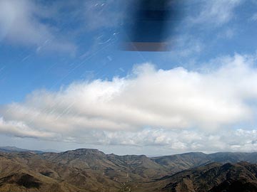
The Big Sandy Shoot, Take 2

I return for a weekend-long rides gig.

Last year, I wrote extensively about the Big Sandy Shoot, an event held north of Wikieup, AZ by MG Shooters, Inc. I’d gone to the event at the urging of my friend Ryan, and although I did some helicopter rides, it wasn’t a terribly good gig for me. But it certainly was a fascinating experience.

A few months ago, the MG Shooters folks contacted me, asking me to come to this spring’s shoot. The rich guy with the helicopter who’d shown up last year and had given free rides had sold his helicopter. I wouldn’t have to compete with him. I checked my calendar, saw that Mike and I had the weekend free, and decided we’d try again. I didn’t expect to do many rides, but I thought it would be a nice opportunity to test out our camper in a real off-the-grid situation. We’d leave Jack the Dog and Alex the Bird at home with a house-sitter and just get away for a weekend. If I did rides, great. If not, I’d brought along a book to read and Mike could study for his helicopter check ride, which is later this week.

Getting There

The weather was bad on Thursday and Friday, with heavy rain throughout most of the day. This was good and bad. Good because the shooters would be able to use tracer rounds during the night shoots without worrying much about starting fires out in the otherwise dry desert. Bad because the shoot location is about 5 miles from pavement on the other side of the Big Sandy River. The Big Sandy River does not have a bridge at the crossing, so you have to drive across the river in whatever water is flowing. And the dirt roads often get a top layer the consistency of snot when they get wet.

Of course, I didn’t have to deal with this. I was flying in. What I had to deal with was the weather itself: clouds, rain, wind, etc. We waited until [too] late in the day to make our go decision. Mike pulled out with the camper in tow at about 5 PM and I went to the airport.

In Wickenburg, the sky was partly cloudy and the winds were no more than breezes. I’d checked the weather along the route 93 corridor where I’d be flying, all the way up to Wikieup and Kingman. It didn’t seem bad, but it certainly didn’t seem good. As any pilot who flies in remote areas can tell you, weather forecasting isn’t exactly perfect for areas where there aren’t any airports or cities. So although my destination was 60 miles from Wickenburg, I couldn’t get any solid weather information for it. I had to extrapolate based on what I was experiencing in Wickenburg and what was going on in Kingman, another 30 miles northwest of Wikieup. The radar images helped. And just looking out the window in the direction I had to fly helped.

The plan was for me to fly up there and scout out the river situation from the air. If the river was flowing too swiftly to drive across, I’d call Mike on the aviation radio he had with him and tell him. We’d set up camp at the Burro Creek campground about 30 miles south on route 93 for the night. I wasn’t sure how they’d feel about a helicopter landing down there, but was willing to find out if I had to. (Obviously, I wouldn’t land in the campground itself.)

Because a straight-line route would have put me in the mountains east of route 93, I decided to follow route 93 itself. (IFR: I follow roads.) There were two benefits for that. First, if weather closed in, I could land near a paved road where I could meet up with Mike or get a ride with someone else if I had to. Second, I could check out Burro Creek campground from the air to make sure there were potential landing zones and open camping spaces.

It was an uneventful flight. The winds were not much more than light breezes. Although there were a significant number of clouds at my altitude, none of them were near my flight path. Instead, they obscured the mountain tops on either side of the valleys I flew up. I never got within a mile or two of any of them.

I passed Burro Creek and saw that the campground was about 80% full. I also noted that they’d never painted the second bridge over the canyon there. (I’d taken a photographer from Utah to shoot the bridges from the air as the second one was being completed at least a year before.) I climbed over the mountains there and dropped down into the valley where the Big Sandy River flowed. It wasn’t flowing much at all. In some places, the riverbed was dry, in other places, there was about a foot of water flowing. It was a lot like the Hassayampa River, which flows mostly underground through Wickenburg. I overflew Wikieup, then concentrated on my GPS to locate the shoot site.

It was a good thing I had the waypoint programmed into my GPS. The shoot was quite a bit farther north and east than I remembered. It was in the foothills of the Aquarius Mountains. A line of clouds at my altitude hid the mountaintops from view. The shoot site was about 1/2 mile from the clouds. A bunch of people were set up on the flattened out ridge top with campers and shade structures.

Now, I’d been told that they’d put in two helipads since the previous year. And try as I might, I just couldn’t find them. I circled once, coming quite close to that cloud bank, then decided to land, shut down, and get directions from the ground. I used my cell phone to call Mike and leave him a message about the river conditions — I knew he was too far out for the radio — then landed on the southwest edge of the ridge.

Zero Mike Lima on its helipadTurns out that the helipads were nothing more than just flattened out areas on the north side of the ridge. Someone had decided that the closer helipad would make a great campsite and had set up a ton of camping gear on it. Ed, the guy who runs the place, suggested that he move, but the guy camped out there wasn’t interested in that. He tried to say that it was muddier there than anywhere else. That simply wasn’t true, although the mud leading up to that spot was terrible. So Ed and I found another place on the east side of the ridge. It was higher and dryer and although it hadn’t been cleared for helicopter use, I had no trouble landing there. Best of all, it was closer to where the shooters and spectators would be hanging out, so I was more likely to get people coming over to me.

With the helicopter settled in and the light fading quickly, my thoughts turned to Mike. Last year, he’d gotten lost on his way in from route 93. I didn’t want him getting lost in the dark. So I found someone with a truck who was willing to take me down to the main road and guide him in. That’s when I saw how muddy the road was. It was almost frightening — especially one steep hill covered in reddish brown snotty mud.

We literally almost ran into Mike. He didn’t know I was in the truck, so he didn’t stop. My driver, Ron (I think), made a U-turn and tried to catch up with him. We were more than halfway back when Mike finally stopped and I switched vehicles. We followed Ron the rest of the way up, checked in at the registration area, then climbed to the ridge and parked the camper near the helicopter.

Night Shoot

We were just finishing the camper setup — which included parking its right wheels on five leveling blocks and using large stones to prevent it from rolling away — when the night shoot began.

A big gun. At night.If you’ve never been to a machine gun shoot, you’re missing a really outrageous event. These guys have the same kinds of guns the military has/had for warfare and I think they have more ammo than the military issues to its soldiers. And they’re not afraid to shoot it. At night they use tracer rounds that clearly show the path of the bullets as streaks of red or green light. The sound of fire is deafening and every once in a while, it would be punctuated by the loud boom of a reactive target (i.e., stick of dynamite) going off.

At 10 PM, the shooting stopped. By that time, Mike and I were already in the camper, getting ready for bed. It started raining lightly outside. It got quiet and we slept pretty well.

The Big Day

In the morning, the low clouds were back, but never really drifted into our area. The big camp slowly came to life as shooters woke. The local 4H club was serving breakfast and the bacon smelled excellent. After breakfast in the camper, I went out with some rags to dry the dew off my helicopter. We hung a sign that said, “Helicopter Rides $35” on the back of the camper, which faced the rest of the camp. At 8 AM, I had my first passengers.

I flew much of the day. It wasn’t nonstop, but it wasn’t stop-and-go, either. Generally, I’d get three or four flights in between shutdowns. Then I’d get out and grab something to drink or take a pee or do something in the camper before the next few passengers showed up. Most flights had just two people on board — most of these guys were pretty “healthy” — and I made the flights a bit longer than I needed to. The later flights were a bit shorter — after all, I wanted to make money on this event — and included a view of the little waterfall in the foothills about a mile east of the camp.

U.S. Firepower in WikieupMeanwhile, the shooters were shooting. They started up at about 9:30 AM and stopped at noon for lunch. Then 1:00 PM to 5:00 PM when they stopped for dinner. They kicked off the 1 PM shoot with the detonation of a pig statue packed with explosives. I was in the air when they did it, but my passengers and I saw the smoke out in the target area. Mike said that the car alarms for all the cars and trucks had gone off.

We used our new fuel transfer tank to refuel the helicopter. It didn’t work quite as expected. Mike got tired of cranking after about 2/3 of the fuel had been pumped and made the fatal error of stopping. The fuel drained out of the hose and we couldn’t get the damn pump primed again. So the remaining 1/3 tank (about 8 gallons) remained in the transfer tank. Later, I made a fuel run to Kingman which took about 5 minutes longer than it needed to when I parked the helicopter about 3 feet farther away from the pumps than the hose would reach and had to start up to move it. (I hate when that happens.)

The weather threatened rain to the east and west of the site most of the day. On a few flights into the mountains on the east, I got drizzled on. We saw rainbows, too. But the clouds broke up around sunset. I stopped flying at 6 PM after taking at least 40 people for rides.

We made dinner in the camper and opened a bottle of wine. Outside, everyone was preparing for the night shoot. It got dark and people started shooting off flares. They’d shoot into the air like a fireworks rocket, then explode. A red light would glide to earth at the end of a small parachute, lighting up the range. Occasionally, one would land before it went out, setting a small bush on fire. But the earth was so wet that the fire soon went out.

The night shoot began loudly. Mike and I walked down the back of the firing line, past the shooters, taking photos and videos as we went. Thank heaven for ear plugs.

The Last Day

By morning, the folks who hadn’t left the night before were packing up to leave. There was another shoot scheduled, but only the hard-core shooters seemed interested. I flew another 10 or so passengers. The waterfall was drier and harder to spot in the canyon. Between flights, Mike and I packed up the camper.

I was on the ground when one of the shooters, a man who had made a canon out of a fire extinguisher, shot a red bowling ball over the range. That thing climbed at least 300 feet, with the wind whistling through its finger holes, before crashing to earth. He’d been shooting the bowling balls all weekend, but I always seemed to miss them. Seeing it was a treat.

Mike and I had lunch, hooked up the camper, and prepared to leave. I took Mike on a quick flight up in the mountains before dropping him off at the landing zone. I flew home the direct route, detouring only to peek into Bagdad Mine on my way back. Total flight time for the weekend: 6.2 hours. When I later tallied up the money, I discovered that I did a little better than breaking even. (Should have made the rides a little shorter.) But it was enough to come back.

The Helicopter Job Market

It’s pretty shameful.

Knowing how to fly a helicopter isn’t exactly a common skill.

It takes at least 40 hours of flight time to get a private license, although most people need at least 60 to pass the check ride. At at least $200/hour, the cost alone is enough to scare most people away from learning.

Then, to get a commercial license so you can do it for hire, you need 100 hours of pilot in command time (at about $200/hour if you rent) and to pass yet another, more stringent check ride.

So then you can get a job, right? Not quite. No one is going to hire a 150-hour pilot to fly their helicopter with paying passengers aboard. In fact, you probably won’t be able to find a job flying for someone else until you have at least 1,000 hours of pilot in command time.

How do you build that time? Most people do it by becoming a flight instructor or CFI. That’s more training, more requirements, and another check ride. Then shamefully low pay rates — maybe $15 to $25/hour? That might sound good, but we’re not talking about a 40-hour work week. You get paid based on when you teach. That might be 10 or 20 hours a week. I don’t know too many people who can live on that.

(I did it the more expensive way. I bought a helicopter and flew the paint off it. Figuratively, of course.)

Captain MariaSo now you’ve got 1,000 hours of PIC time, accumulated over a period of about 2 to 3 years. You’re ready for a “real” job. Fly tours at the Grand Canyon (like I did). It’s great experience, but the pay is only slightly better than what a CFI gets. Fly in the Gulf of Mexico, bringing oil rig workers and VIPs to and from platforms on a featureless, watery landscape, miles from land, in good and bad weather. More good experience, slightly better pay. Pretty crappy living conditions, from what I hear. And I don’t think many women work out there. (Would love to hear from a woman who does; use the Comments link.)

Want a high paying job? One of those $80,000/year job you hear about on radio commercials and in seminars? You’ll need several thousand hours of turbine helicopter experience (which you usually can’t get as a CFI), long line experience, and a “OAS/USFS card.” You’ll have to work your way up through the ranks on other kinds of helicopters to get to this stage.

And, oh yes, you have to be willing to be away from home at least 14 days out of every month.

My friend, Rod, is among the handful of people who qualify for the good paying jobs. He does all kinds of long line work — logging, fire fighting — you name it. But the long hours, questionable living conditions, and time away from home burns him out so badly, he can only work half a year. He actually spent a winter delivering propane (from a truck) just to get away from flying.

Think I’m lying about job requirements? Check out these links for helicopter jobs:

Even police helicopter pilot jobs start at less than $50K. And they require police training, too.

And I think that’s amazing. Helicopter pilots have an incredible skill that few other people have. They have thousands of dollars and hours invested in their training and experience. They’ve worked their way up from the bottom, with low pay and unfavorable working conditions most of the way. And only a handful will ever achieve the high pay you’d think would come at the end of the dues-paying process.

I’m fortunate enough to have two jobs, so I never have to depend entirely on helicopter pilot pay to cover my living expenses. Still, that tour pilot job in Hawaii remains beyond my reach — until I get another 650 hours of turbine time…