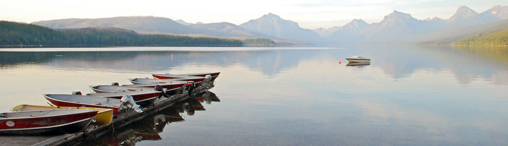
A helicopter flight that has become routine.
As I write this, 36% of the site visitors who have taken the time to vote in my Most Interesting Topics Poll (that’s 11 people so far; I’m hoping for continued growth in that vote count) have said that Flying is the most interesting topic on this site. So I decided to devote this morning’s blog session to a flying article.
(For those of you just tuning in for the first time, among the hats I wear is a commercial helicopter pilot hat. I operate a Single Pilot Part 135 helicopter tour and charter company out of Wickenburg, AZ — Flying M Air.)
I flew yesterday. I flew three passengers from Wickenburg to Sedona and back. The passengers were originally from Russia and now live in the U.K. They’re staying at the Flying E Ranch, one of Wickenburg’s remaining three guest ranches.
I can’t get excited about this flight. It was so routine. After all, by now I must have flown from Wickenburg to Sedona and back at least 50 times.
The only thing unusual about the flight yesterday was visibility. In Arizona, it’s clear and sunny almost every day. Not only can I usually see the Weaver Mountains about 15 miles to the north, but I can usually see them clearly — that means I can distinguish rocks and canyons and other features from 15 miles away. But yesterday was different. It was hazy, as if a thin gauze had been stretched across my eyes. As I drove to the airport at about 10:00, it was apparent why: there was moisture in the air. There was condensation on my Jeep and even a little frost down where the horses were munching their morning meal. Imagine that. Moisture.
My passengers arrived early, all bundled up for the 50°F temperatures we expected in Sedona. After giving them their preflight briefing and loading them on board, I started the helicopter and waited for it to warm up. A few minutes later, we were on our way, climbing to the northeast into hazy skies.
The air was smooth, the sights were the same as usual (except for the haze) and I pointed them out faithfully to my passengers. They didn’t talk much, which is always a danger with me. I wind up talking to fill the silence, telling them more about the area than I usually do. I had three passengers on board, so I had to make sure I pointed out things on both sides of the helicopter — normally, with just two on board, I put them on the same side of the helicopter so I only have to point out things on one side.
We crossed the Weaver Mountains not far from the hidden cabins I’d discovered years before. Then we followed the Hassayampa River up toward Prescott, crossing the Bradshaws. My passengers were thrilled by the sight of snow on the north side of the moutains. I was thrilled by the fact that the haze had cleared out and it was a nice, clear day up there.
As we got close to town, I reported in to the tower at Prescott Airport. I planned to follow Route 69 a bit and then head toward the pass atop Mingus Mountain. This would have me cutting as much as one mile into Prescott’s airspace. (I normally go around it so I don’t have to talk to the tower, but our heavy weight had our airspeed a bit slower than usual and I wanted to save a few minutes of time.) We were over Prescott Valley when the tower pointed out a Baron about 400 feet above us, crossing in front of us. I descended about 500 feet — I was high because of all the mountains I’d have to cross — to stay out of his way. Then the tower cut me loose and I climbed up and over Mingus Mountain, reaching my highest elevation of the flight: about 8,000 feet.
 From there, I started a 1,000 fpm descent to the northwest, descending past the former ghost town of Jerome. I told my passengers about the first time I’d been there nearly 20 years ago when only a handful of people lived there. Now it was a booming tourist town, with art galleries and restaurants in the old buildings perched along its hillside. I showed them the open pit mine, then continued northwest to the red rocks. We did a red rocks tour on the way into Sedona, avoiding the flight path of the helicopter tour operators there, and landed at the airport.
Uneventful.
Of course, I’d been so concerned with getting my credit card terminal to work at the airport that I’d forgotten to bring a book or my laptop so I’d have something to do while my passengers went on their Jeep tour. Duh. After the Jeep picked them up, I walked over to Sedona’s restaurant for lunch. (I don’t think I can recommend the Chicken Alfredo with Broccoli; too thick and starchy, although the chicken was cooked nicely.) Then back to the terminal to wait.
I wound up renting a car from the car rental guy there. $20 for up to 3 hours (I think). I didn’t even have it two hours. I drove down off Airport Mesa and hit the New Frontiers grocery store at the bottom of the hill. It has a magnificent selection of cheese and a very knowledgeable cheese guy behind the counter. I tasted some cheeses and wound up buying them all. I also bough brussels sprouts on the stalk — something that’s simply not available in Wickenburg.Then into “uptown” Sedona to visit a bookstore (the Worm) which seemed to have fewer books than I remember. And coffee at the coffee shop across the street. Then back to the airport so I’d be there when my passengers returned.
I talked to everyone who worked at the airport. The car rental guy, the AZ Adventures helicopter tour guys, the FBO guys, and the Maverick helicopter tour guy. That kept me busy even after my passengers returned from the Jeep tour and went to have lunch at the airport restaurant. By 3:30 PM, they were back and it was time to go.
The return trip was almost as routine. The haze had moved in a bit and we were flying right into the sun. My hat was under my seat, so I had to shade my eyes with my hand once in a while. Instead of heading straight for the southern end of Mingus Mountain, we headed southeast to Oak Creek Village. My front seat passenger had his camera out and the red rocks were being illuminated by that gently filtered afternoon sun. The views out that side of the helicopter were great. I flew just past Oak Creek VIllage before turning to the southwest, back into the sun. The mountains rose as dark shapes silhouetted against the hazy light.
I didn’t have as much to say on the way back. Part of that was my intercom system, which was creating static again. (I have to fix that! It’s driving me nuts!) So I had the squelch set so it was less likely to make noise. My passengers weren’t talking anyway. They were just looking; the daughter, who was probably close to 18 years old, had her iPod on under her headset and probably wouldn’t have heard what we were saying anyway.
The farther south we flew, the worse the haze got. It was definitely brownish in color toward the Phoenix area — smog trapped in an inversion. At one point, we could clearly see a dark line in the sky that marked the inversion layer. Very unusual.
I flew them over Crown King, a tiny town in the Bradshaw Mountains. The main reason I go that way on the way back is that you can normally see Wickenburg Airport from the Crown King area — a distance of about 23 nautical miles. But not yesterday. The haze was so complete that if I didn’t have my GPS set to Wickenburg (or at least a heading in mind) I would have strayed off course. I simply couldn’t see that far away. Even Lake Pleasant was difficult to see from the air, although I did point it out for my passengers as we flew about 10 miles north of its northern edge.
We were over the Monte Cristo mine on Constellation Road when I was still trying to figure out exactly where we were. When I saw the mine shaft and buildings, I thought I’d stumbled upon a mine I’d never seen before. Then I recognized it and was surprised that we were so close to town. Less than 10 miles to the airport, according to my GPS. I could just about make out reflections downtown and the scars of the earth around the airport.
I flew over town and then headed out to Flying E to show them the ranch where they were staying from the air. (That’s something I do for people staying in our local hotels and guest ranches.) Then we landed by the fuel pumps at the airport. I cooled down and shut down.
Routine.
After a while, flying the same route over and over does become routine or — dare I say it? — boring. Sedona is a place of incredible beauty and the best way to appreciate its beauty is to see it from the air. Yet when you’ve seen it as many times as I have, the impact of all that beauty fades. That’s one of the things I talked to the FBO guys in Sedona about. They both agreed that when they’d first come to Sedona, they were amazed at its beauty. Now, living with it all around them every day, it simply isn’t a big deal.
I felt like that when I flew at the Grand Canyon, too. Don’t get me wrong — it never got so boring that I’d prefer to fly elsewhere. I just wished I had the freedom to alter my flight path for a slightly different view or a new way of seeing things.
And here in Wickenburg. The upstairs front windows of my home look out over the Weaver Mountains in the distance. When I first moved into the house, I thought it was a view I’d never grow tired of. But I did. Kind of. I’m not sure why.
I’d be interested in hearing from other pilots who fly in beautiful places and have somehow lost sight of that beauty because of routine. Use the Comments link.

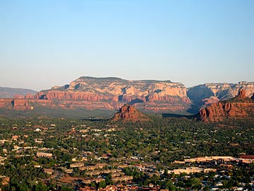 From there, I started a 1,000 fpm descent to the northwest, descending past the former ghost town of Jerome. I told my passengers about the first time I’d been there nearly 20 years ago when only a handful of people lived there. Now it was a booming tourist town, with art galleries and restaurants in the old buildings perched along its hillside. I showed them the open pit mine, then continued northwest to the red rocks. We did a red rocks tour on the way into Sedona, avoiding the flight path of the helicopter tour operators there, and landed at the airport.
 I won’t go into details about the roads I tried and the wrong turns I took. Suffice it to say that I finally homed in on it. After driving down a two-track road that cut diagonally across the main runway, I parked my Jeep right in front of the gaping hangar door.
 One thing is for sure: visiting the old airport and looking up at the faded paint over the door spelling out “Grand Canyon Airlines” has given me a real thirst for knowledge about the place. When I’m finished with my road trip book project and trip to Canada (for work), I might start doing a little research.

 In December 2004, I applied for a permit to conduct helicopter tours to
  You might be asking why I need a permit to use public land. BLM, in case you’re not aware, stands for Bureau of Land Management. It’s a part of the Department of the Interior. Of the Federal Government. These are government managed lands that belong to the people. And the people can use them, as long as they follow certain rules. Among those rules are that if you want to make money by operating a tour or anything else on BLM lands, you have to get a permit.