Brew and Go

I get a new coffee maker…again.

It’s disposable products all over again.

Brew and GoI’ve been using a Black and Decker coffee maker called “Brew and Go” (formerly, “Cup at a Time”) for about fifteen years now. I like fresh-brewed coffee every morning, but Mike doesn’t. It’s silly to make a whole pot — even if I do want a second cup, I won’t take it from a pot that’s been sitting on a burner for 30 minutes. So I make a single fresh cup every time I want one.

(And in case you’re wondering, I usually don’t drink brewed coffee in restaurants. Burner sludgification is one reason. The other is that most restaurants out here don’t know how to put enough coffee in the brew basket to make a strong enough cup. I think it’s because it’s pre-measured and it comes in bags. This is the same reason I’m avoiding those “pod” coffee makers. You can get decent restaurant coffee in New York and on the west coast, but in the midwest, southwest, southeast, and elsewhere, the only way I can get a cup of coffee that’s strong enough for me is to order a latte at a coffee shop.)

The other day, I bought my fourth or fifth one of these coffee makers. They work fine for about two years, then they start getting unreliable. The usual symptom is that they stop brewing before all the water in the reservoir has been heated and pumped up to the grinds. You wind up with a 2/3 full cup of coffee with leftover water. It isn’t a big deal to push the button again — usually that’s enough to get the rest heated and brewed. But experience has taught me that this is only the first of the pot’s symptoms. The next step is that button getting broken. And when that happens, the coffee maker won’t work at all.

So I consider the funky button a warning sign. I’ll need a replacement soon. So I went online and found a replacement for a good price on Amazon.com. (Note to my critics: Sadly, you can’t buy anything like this in Wickenburg, so shopping locally was once again out of the question.)

Oddly enough, they showed two models and the only difference I could see between them was the size of the machine. Since both were under $20 with only a $4 price difference and I figured that I could use one in my hangar, too, I bought them both. I was curious to see how they differed.

They arrived yesterday. Their boxes are identical with two exceptions:

  • One box says “Deluxe” (that’s the $17.99 model) and the other doesn’t (the $12.99 model).
  • One box illustrates and identifies a stainless steel travel mug (the $17.99 model) and the other one illustrates and identifies a plastic travel mug.

I opened the deluxe model and got a good whiff of the plastic aroma that accompanies many new appliances made primarily of plastic. I pulled out all the packing material, plugged it in, and brewed through some plain water. Then I decided to read the instructions for some tip to get the smell out. The instruction book only had four pages in English — not much to instruct.

Of course, the unit is made in China. I’m not sure if the original “Cup at a Time” was made in China. It was a long time ago. It was probably Taiwan back then.

I brewed up a cup of coffee using the built-in filter basket. I usually don’t use that thing because grinds get through it into the coffee. I like my coffee very strong and usually grind the beans to the first “Fine” setting on the machine at the supermarket. The “gold” filters that come with many coffee makers simply aren’t fine enough to prevent the grinds from going through. But I figured I’d try it a few times. If I could make a good cup of coffee with the reusable filter, I’d save a few bucks on paper filters — not to mention the time it takes to cut the #2 cone filters down to size. I’ll experiment over the next few days and maybe even get some coffee ground a litte coarser.

The first cup of coffee tasted a bit like the plastic I smelled. Or at least I assume so — I don’t make a habit out of tasting plastic. There’s a puddle of finely ground coffee at the very bottom of my cup, like mud on the bottom of a pond. The first problem will be remedied with time, the second will probably require a grind or filter change.

But the coffee maker performed flawlessly, using up all its water and making a nice, hot cup of coffee.

The old coffee maker is now sitting in the trash like the three or four that came before it. As we all know, it’s usually more expensive to get these things fixed than to buy a new one. That’s how the disposable economy came into being.

A little side story here. Our original DVD player only lasted about 5 years. We tried to get it fixed and everyone we brought it to quoted us a price to look at it that was more than the thing was worth. Then we tried to give it away to a school or electronics repair training facility so the students could use it to learn about the machine and/or how to fix it. No one would take it. Mind you, this isn’t a machine that had been abused. All of its parts pretty much still worked. It just didn’t play DVDs anymore. The only option was to throw it out.

I recently sold two very old Macs (an 8500 and a beige G3) on eBay. I got 99¢ for one and $9.99 for the other. Plus shipping, of course. Although I’d spent a total of more than $5,000 for the machines years ago, I was willing to take the money. Not because I needed the $10.98 but because I didn’t want to take the two machines — which were still perfectly functioning — to the landfill.

I guess their new owner will do that one day.

It’s time for another cup of coffee.

Technorati Tags:

Is Organic Really Good?

An article in Slate comments on Whole Foods marketing and reality.

If you’ve ever wondered whether organic food is more than just marketing, read this:

Is Whole Foods Wholesome? by Field Maloney.

I do have a mildly amusing story about organic food, so I may as well tell it here.

Years ago, Mike and I went for a week-long vacation in Hawaii with Mike’s cousin Ricky. Ricky is heavily into health foods and the like — or at least he was back then — and insisted that we buy organic fruit for snacking while we traveled.

I had a terrible cold and we bought some oranges at a supermarket so I could suck down the vitamin C and soothe my sore throat with the juice. They were delicious oranges, sweet and juicy, and I really enjoyed them.

But because Ricky wanted organic fruit, we tracked down an organic food market and bought some extremely ugly — but organically grown — oranges. They were terrible. Tough skins and membranes, dry pulp, and not even sweet. Mike and I refused to eat them. Ricky finally threw them away.

He never bugged us about buying organic again.

Now I’m not trying to say that organic is bad. I’m just saying that it isn’t always good.

Southwest Circle Helicopter Adventure

I offer, for your perusal, the first draft of a 9-day helicopter charter I plan to offer passengers.

Yesterday, I spent the day in Sedona, AZ. I had a charter there that morning, and while my passengers were doing a Jeep tour, shopping, and having lunch, I spent the time planning a trip I’d been thinking about for a long time.

I’m interested in getting feedback. Take a few moments and read up. Use the Comments link to let me know what you think. Don’t balk at the price; it’s actually an incredible deal for about 9 hours of helicopter flight time over one of the most scenic areas of the U.S., plus lodging, other tours, and some meals.

Keep in mind that this posting is not an actual offer. Once I fine-tune the details, I’ll be offering the tour on the Flying M Air Web site. I’ll add photos and a table that lays out exactly what’s included each day. If you’re interested in actually taking this tour, contact me through that site and let me know. It would be great to do the first tour with someone who learned about it here.

Day 1
Your southwest circle adventure begins at Phoenix Sky Harbor Airport, where you’ll meet your helicopter pilot and climb aboard a 2005 Robinson R44 Raven II helicopter. This helicopter includes many luxury features, including leather seats, bubble observation windows, noise canceling headsets, voice activated intercom system, iPod-compatible stereo audio system, and state of the art GPS navigation system.

You’ll make the 60-minute flight to Sedona, AZ via the Verde River and beautiful Oak Creek for your first stop at “America’s most scenic airport.” You’ll take a 10-minute shuttle ride to Uptown Sedona for a 2-hour Jeep tour among Sedona’s famous red rocks, shopping, and lunch or dinner on your own. Then its back up to Airport Mesa where you’ll check into your red rock view room at Sedona Sky Ranch. Sit on your room’s deck and watch the sun set over the town.

Day 2
In the morning, return to the helicopter for the 45-minute flight to Grand Canyon Airport. You’ll start your visit to the Grand Canyon’s South Rim with a 25-minute helicopter tour over the Grand Canyon with one of the park’s licensed tour operators. At the end of the tour, board a shuttle bus for the 15-minute ride into Grand Canyon National Park. Enjoy a walk along the Rim, browse through the gift shops and museum displays, have lunch, take a bus along West Rim Drive for a variety of canyon views. You can even take a short hike into the canyon itself. In the afternoon, you’ll check into your room at one of the park’s South Rim accommodations, walking distance to the Rim and its incredible views.

Day 3
After breakfast at historic El Tovar hotel, courtesy of your pilot, return to the airport where the helicopter waits. From Grand Canyon Airport, it’s a 45-minute flight to Page on Lake Powell. Possible activities in Page include a Navajo-led tour of Antelope Canyon, (an incredible slot canyon carved through the sandstone), a tour of the Glen Canyon Dam, and a boat tour on Lake Powell. Ground transportation is available via the free shuttle provided by the park service concessionaire. You’ll spend the night at the Wahweap Lodge, where you can stroll along the water’s edge at sunset.

Day 4
In the morning, return to the airport and your helicopter for the next leg of your trip, a 45-minute flight along the southern edge of Lake Powell to Monument Valley. You’ll land at the airstrip at Goulding’s Lodge, a historic trading post with restaurant and motel. From there, you’ll take a 3-1/2 hour tour of Monument Valley, driving among the famous sandstone buttes with Navajo guides. Then it’s back to your room at Gouldings, with its private balcony overlooking the valley.

Day 5
The next day, you’re off to Bryce Canyon. The 1-hour flight will cross Lake Powell and miles of high desert landscape, passing by the east side of Bryce for a glimpse of the famous hoodoo formations before landing at the Bryce Canyon Airport. You’ll go into the park where you can walk along the rim, taking in the sights as you go, or descend on well-maintained trails among the rock formations. Hotel accommodations are in the park, at the Bryce Canyon Hotel.

Day 6
Start the day with an hour-long flight to a remote ranch on the north rim of the Grand Canyon: Bar 10. This unique destination is a waypoint for Colorado River runners starting or ending their adventures. If we arrive early enough, you’ll see helicopters taking passengers in and out of the canyon. When things calm down, enjoy horseback riding, skeet shooting, and a cowboy show. All meals are included for this part of the trip — the ranch is so remote, there’s no where else to eat! Even the sleeping accommodations are something special: you’ll share a covered wagon for the night after seeing more stars than you thought existed.

Day 7
The next morning, it’s off to bright lights in the big city. After an hour-long flight over high desert and Lake Mead, we’ll touch down at North Las Vegas Airport and take a taxi to a hotel along the Famous Las Vegas Strip. You’ll be on your own to explore casinos and shopping opportunities. But make sure you’re available that evening for a Neon Lights tour along the strip with Papillon Helicopters.

Day 8
The adventure continues when we leave Las Vegas for Grand Canyon West on the Hualapai Indian Reservation. You may catch a glimpse of the Hoover Dam as we cross Lake Mead and head east on the 45-minute flight. After a coach tour out to Guano Point for sweeping views of the canyon and a buffet lunch, you’ll board a helicopter for a trip down into the canyon and a boat ride on the smooth waters of the Colorado River. Afterwards, relax in the helicopter for the 90-minute flight to Wickenburg, a western town perfect for unwinding on the last night of your adventure. Unwind at a downtown motel, near shops, restaurants, and the historic area.

Day 9
Spend the last day of your trip in Wickenburg, strolling through the historic area, browsing shops, visiting through the museum, or just taking it easy. When you’re ready to return to Phoenix for the return trip home, your pilot will take you to the airport.

Package Price:
$8,995 double occupancy for two people; add $1,995 for separate rooms. Prices includes taxes and other fees.

Reservations are required at least 30 days in advance. A 50% deposit is required at the time of reservation. Cancellations within 30 days of departure date are subject to a $200 cancellation fee. Deposits are forfeited for cancellations within 14 days of departure date. (Trip insurance is recommended if you think your travel plans may change.) Flying M Air reserves the right to change hotel accommodations and some services from what may be listed here in the event of unavailability. In all instances, substituted accommodations and services will meet or exceed those offered here.

Package price includes air transportation, tours, and lodging (double occupancy) as described, some ground transportation, and some meals for up to two people. Passengers are responsible for all incidental costs not specifically included in the description, including most meals, some ground transportation, and the cost of personal items purchased on the trip.

Total passenger and luggage weight is limited to 500 lbs. Luggage size is limited by stowage space constraints; details will be provided at booking. Walking distances up to 1/4 mile is required at several stops. Some accommodations have limited facilities due primarily to their locations in remote areas. This trip is not recommended for people with health problems or special dietary needs, or people who have difficulty getting around. Trip starts and ends at Phoenix Sky Harbor Airport (or another Phoenix area airport of the passenger’s choosing).

Important Note:
This trip is not being offered as a tour. Instead, it is a series of charter helicopter flights, for transportation purposes only, packaged with lodging, some meals, and tours offered by licensed tour operators at destination locations. Although the helicopter flights pass over and through some of the most incredible scenery the southwest has to offer, Flying M Air is not a tour operator in these areas and is not conducting the flights as tours.

Sedona Sky Ranch

One of Sedona’s little secrets.

When we have out-of-town guests, we sometimes take them to the usual tourist spots in Arizona. (I can’t tell you how many times I’ve taken people to the South Rim of the Grand Canyon.) This past week, Mike’s mother has been in town. And over the weekend, we took her to Sedona for an overnight stay.

Sedona is a beautiful place. It has also become a bit of a tourist trap. “Uptown” Sedona is full off gift shops and counters for booking tours. Its sidewalks are roamed by people trying to get you to come see their timeshare opportunities. (I never could understand the attraction of timeshares.) If you’re looking for a t-shirt or a piece of Indian jewelry or some junky souvenir of red rock country, this is the place to come.

Uptown Sedona is right at the mouth of Oak Creek Canyon, a beautiful spot with a year-round creek, shady trees, and towering cliffs. A drive up through the canyon is the nicest way to reach Flagstaff, especially in the fall when the leaves on the trees along the creek are changing color.

So right before you reach the beauty of Oak Creek Canyon, you have to drive through the most touristy cluster of shops in Arizona. The same shops that block the views of some of the incredible red rocks that people have supposedly come to Sedona to see.

To be fair, Sedona’s local government has enacted certain zoning laws that require new construction to blend in with the environment. That’s why you’ll see a lot of reddish buildings. It’s also one of the few places I’ve seen dozens of homes painted a dark sage green–to match the scrubby desert pine trees that grow in the area. Unfortunately, those laws were not passed before Uptown Sedona was developed, so most of that area is pretty ugly.

We planned to spend the night in Sedona and needed a place to stay. We wanted to stay at a nice place–the last time we’d taken his mother on a trip in Arizona, we’d stayed at a weird place down near Tubac that had been built on top of an old missle silo. (I can’t make this stuff up.) Mike surfed the Web and came up with a place that included the word “Spa” in its name. The pictures looked good, but it was supposedly in West Sedona. I was worried that it would be too far away from the things his mom wanted to see–primarily shops–or tucked away in some back corner without any views. So I suggested a place where I knew there were good views: Sedona Sky Ranch.

Sedona Sky Ranch is Sedona’s airport motel. And that’s why so few people consider it as a place to stay. I consider it one of Sedona’s little secrets.

Sedona Airport is on a mesa just south of town. For those of you who didn’t pay attention during geology lessons in school, a mesa is a flat-topped mountain. There are a lot of them in Arizona and the rest of the southwest. Sedona’s airport sits on one of them. (The St. George, UT and Bagdad, AZ airports also sit on mesas.) It’s kind of neat because as you approach the runway in a plane, it’s a lot like landing on an aircraft carrier.

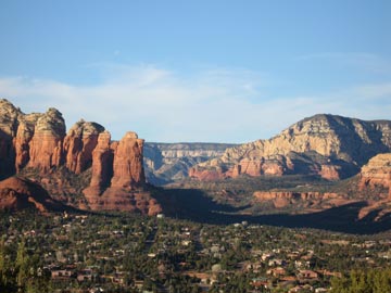
Sedona Sky Ranch is on the northwest side of the mesa, walking distance from the airport’s little terminal. It sits on the edge of the mesa and has about a dozen rooms that look right out over the town. And the red rocks beyond it.

View from Sedona Sky RanchWe’d reserved two Red Rock View rooms for the night. The rooms included 2 queen beds, a deck overlooking the views, and a kitchenette with a small fridge, microwave, and sink. And a bathroom, of course. Not what I’d call luxurious, but certainly very comfortable. And the views! At about 500 feet above the town, we didn’t have to look at any ugly commercial buildings. Sedona’s famous red rocks were right there. The photo here shows the view from our deck. The rock formation in the left center is called the Coffee Pot. (Think percolator.)

Mike and I shared a bottle of wine on the deck while the sun dropped down on the horizon, making the red rocks even redder. (Mike’s mom watched television in her room.) In the overlook parking area, which was a few hundred yards away, a native American musician played the drum and flute while tourists looked on. The sun set, the flute stopped abruptly, and the tourists got into their cars to go down to their hotels far below us. The full moon rose above the buttes in the east.

The next morning, when we checked out, we made reservations for October. We chose the cabin next door, which is slightly larger that our room, has a larger deck, and a slightly better view. We’ll drive up in the Jeep with Jack the Dog (they allow pets) and spend a few days exploring the back roads of the area while the autumn leaf show is in progress.

It’ll be a nice escape.

Oh, and that “spa” Mike found online? It was on the main road in West Sedona, right next to the Safeway shopping center. How’s that for atmosphere?

10.6 Miles on Horseback

Four of us join Mike on his annual ride to Wickenburg Mountain.

Every winter, Mike takes Jake, his horse, on a ride to Wickenburg Mountain. Altough this mountain is only about 3 miles as the crow flies from our house, there’s no trail that goes right to it. Instead, you have to pick your way along a maze of trails that go up and over or around about a dozen ridges.

Wickenburg Mountain is not named Wickenburg Mountain on any map I have. I don’t know where Mike got that name for it. Someone probably called it that and Mike remembered the name. If you’re looking at a topo map for Wickenburg, it’s the 2977-foot peak at the north end of the Vulture Mountains, south of Turtleback Wash.

I don’t usually go with Mike on this ride. He’s out most of the day and he always brings back stories of bushwhacking through the desert. While there isn’t much bush to whack in the desert, riding off trails (which is what I mean here) can often take you to the edge of cliffs that even horses can’t climb down. I don’t enjoy putting my somewhat neurotic horse through that kind of experience, especially with me on his back.

But yesterday, he’d invited Janet and Steve, who were visiting from Colorado, and Hans, who has recently gotten over a broken ankle suffered when his horse fell on him. I thought it would be nice riding with a small group of friends, so I went along for the ride, too.

Also along for the ride were Jack the Dog and Janet and Steve’s two dogs, Tasha and Maggie. And when my neighbor’s dog, Trixie, saw us leaving, she decided to join us, too. Tasha wasn’t too happy about that and kept attacking her, but after a while, they calmed down and tolerated each other nicely.

We started out from our house, taking the trail beside my neighbor’s property that would take us into the state land south of our house. We rode familiar trails that dropped us into a tributary of Turtleback Wash, where a Jeep trail ran.

The ride up to that point had been pleasant, following trails we knew. It was a lightly overcast day, cool and comfortable. We saw some mule deer, which gave Jack something to chase. As I rode, I began stripping off a few outer layers. My horse was behaving well — which means he was behaving like most other horses, for a change. He was even trotting nicely when we trotted. And he hadn’t bitten the butt of the horse in front of us yet, either.

From the Jeep road, things got iffy. The road ran mostly northeast to southwest, but we needed to go southeast. But we followed the road southwest, looking for a trail or road that would branch off to the left. Steve was leading at that point and he led us right by a possible trail. I’d seen it but didn’t think it was a trail. It turned out to be an old mining road. We followed it in the right direction, climbing a steep hill. We paused near the top to rest the horses and give the dogs some water. Then we continued and, moments later, the road ended.

Dang.

Mike led and the bushwhacking began. We rode over steep, rocky terrain, past nasy cacti and thorny trees. We climbed, we descended. At one point, we reached what I thought was the edge of a cliff. But Mike steered Jake down it and Jake, the good horse that he is, just went. We followed.

Eventually, we ended up on another Jeep road in another wash. We could see Wickenburg Mountain and it was much closer. We even saw a string of four horses and riders coming down one of its old mining roads. But there were more hills to climb over or around. Fortunately, there were also a lot of roads. The trick was to pick the right ones.

We did pretty well. At one point, we rode up a steep piece of road and I heard Hans say, “Oh no. That looks like the kind of place we fell.” He was referring to his recent horse accident, when he tried to walk his horse up a steep hill and his horse slipped back and fell on him, breaking Hans’s angle and chipping numerous bones in the horse’s foot. We hurried up the hill and I was comforted to hear him right behind me.

Wickenburg Mountain Lunch SpotWe reached the base of the mountain and climbed on another road. About two thirds of the way up, on a road that wound past the front of the mountain’s peak, we stopped for lunch. We tied the horses to bushes along the road; they were so tired, they didn’t seem interested in moving. Then we sat down on the rocky slope, opened up our lunch bags, and ate.

Tasha and Trixie had a huge fight right behind my back, nearly knocking me over, but they broke it up when Mike squirted them with his water bottle. Then they settled down and rested. Jack the dog was smart and hung out in the shade.

Jake on Wickenburg MountainOur lunch spot had incredible views of Wickenburg several miles to the north and east of us. But for some reason, I didn’t take any of those pictures. I did get one of Jake with the town in the background, far in the distance. But most of the rest of the photos I took were for wickenburg-az.com, my so-called “labor of love,” which features random header images. To get just the right image, the photo needs to have something on the left and nothing much on the top right. Go to the site and keep refreshing the page to get an idea of what I’m looking for. The image changes on every page, every time it’s refreshed. There are about 20 images now and one blank image that I’m trying to remove.

(But Larry doesn’t want to read about this. I’m starting to talk too much about computers. Sorry, Larry.)

The back side of Wickenburg MountainAfter lunch, we mounted up again and continued on a trail that led to the back side of Wickenburg Mountain. The trail climbed up through beautiful Sonoran desert to a saddle between the mountain’s peak and a lesser outcropping. This is where I took my favorite photo of the day — this vertical shot of the peak’s side and some saguaro cacti. I was very surprised to see a fence and drag gate up there. Mike dismounted and handled the gate for us and we all squeezed through. On the other side of the fence was just a tiny bit of level ground before the land dropped off on a steep downhill slope. There was a trail and Mike led the way down it.

We wound around the back of the mountain and joined up on some old mining roads again. We followed those back toward the main Jeep road. And that’s where we made our wrong turn. If we’d gone right, we would have hooked back up with Turtleback Wash and, from there, we could have found easy trails back to our house. But we went left, following the Jeep road back toward where we’d bushwacked down the mountainside.

How do I know all this? It isn’t because I have an excellent sense of direction and keen eye for landmarks. My sense of direction is good but my eye for landmarks sucks. That’s one of the reasons I had my GPS with me. And my GPS has a moving map with the local topo maps loaded in. I could see exactly where we were and exactly where we needed to go to avoid bushwhacking.

But Mike wasn’t interested in any of that. “We’re not in a hurry,” he told me.

Well, I wasn’t in a hurry, but I was interested in getting home. Especially since most of our water was gone and I was worried about Janet’s dogs, who seemed to have some trouble keeping up.

So we went left down the road. There was a gate across the road and Mike opened it so we could all go through. And we continued along the wash while the hills rose ever taller on both sides of us. Soon, we were riding into a narrow canyon. And then the canyon ended with a steep rocky cliff carved out by the force of water over thousands of years.

Dead end.

Flume in a Dead End CanyonWe paused there to give the dogs more water and explore the cliff face. There was a neat shelf where you could imagine water gathering in a pool after coming down a flume. (This photo doesn’t do the place justice.) The horses got goofy in the narrow area and Steve’s horse almost ran off. So we mounted up and backtracked, looking for a place where we could — dare I say it? — bushwhack over the ridges to the north.

So the bushwhacking began again. This time, the hills were steeper and, for some reason I can’t comprehend, we managed to get separated. Steve was the first to get down to the wash on the other side. Hans made it soon afterward. Then Mike and I, together. Janet was trapped on top of the ridge, unable to find a safe way down. I think the problem was that none of the ways down looked safe and Janet just happened to be a lot more cautious than the rest of us. So Steve rode back up and she followed him back down.

More bushwhacking. I really don’t like it. Cherokee, my horse, managed to cut his nose on a tree or something, so he wound up with a bloody nose. Janet’s dogs were definitely trailing behind. We stopped to give them water again and pretty much finished off all the water. We’d been out for about five hours.

We finally climbed onto a ridge and saw a familiar Jeep trail ahead of us. A few moments later, we were on the trail. We took turns leading the way. Soon, we were coming back through the gate by my neighbor’s house.

We unsaddled the horses and hosed ours down. (Cherokee hates getting hosed, but he really needed it. Of course, he got us back by rolling in horse manure right after his “bath.”) Hans and his horse hurried home while Janet and Steve put their horses in one of our corrals and joined us up at the house for drinks. Trixie went home. Janet’s dogs were walking on very sore feet. They admitted to us that their dogs had become “couch potatoes.” Our dog, Jack, was obviously tired, but didn’t seem quite as sore.

According to my GPS, we’d travelled 10.6 miles in about 3-1/2 hours of riding with about 1-1/2 hours of non-movement time. (I figure that Jack the Dog and Trixie must have covered at least 50% more distance.) Our average speed was 3 MPH; our top speed (on a gallop, I suppose) was just over 10 MPH.

This morning, it was me who was sore. You don’t realize how many muscles you use when you ride a horse. I think I can feel every one of mine.