Cramming a lot into three days.
Last weekend, I took Alaska Air/Horizon from Phoenix to Wenatchee, WA. I left on a Friday morning with the goal of being back in Wickenburg with my helicopter on Sunday night.
Friday: The Travel Day
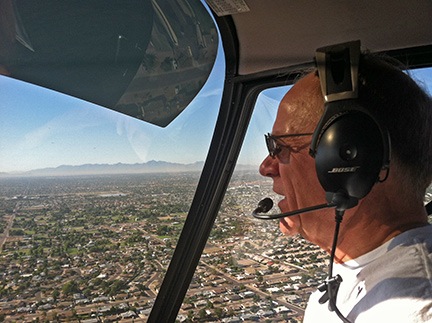
Don at the controls, over Peoria, AZ.
My day started early at Wickenburg Airport. My friend, Don, came to pick me up in his helicopter at about 8:30 AM. After topping off his tanks with fuel — which was cheaper at Wickenburg than his winter base in Deer Valley — we headed southeast.
Don is one of my good friends. Like me, he lives in Washington in the summer and Arizona in the winter. But unlike me, his main home is in Washington; mine is in Arizona. The past two winter seasons, we shared hangar space — at least part time — at Deer Valley Airport. That’s where we met. Don owns an R44 like mine but blue. He’s retired and likes any excuse to fly. On Friday morning, I was his excuse. He came up to Wickenburg, picked me up, and flew me down to Sky Harbor.
What most folks don’t know is that Sky Harbor Airport in Phoenix has a public helipad on the top of the Terminal 3 parking structure. (Don’t believe me? Next time you’re at the airport, take your car up there to the roof and see for yourself.) The helipad doesn’t get much use. In fact, I’m willing to bet that Don is one of the top 10 users with me in the top 20 during the winter months. I blogged about the helipad here and here and even put a video online here.
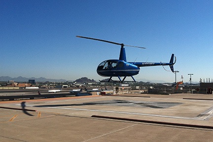
Don’s departure to the north.
Don dropped me off with my limited luggage, waited until I was clear of the helipad, and flew away to the north. I had just two small bags: an overnight bag that contained primarily camera equipment and my Bose headset bag. My A20 headset had been repaired under warranty and shipped back to my Wickenburg home; I wanted to use it on my upcoming long distance flight.
I took the elevator down to the baggage claim level, went out to the curb, and waited for the airport shuttle bus. I was at Terminal 3 and needed to be at Terminal 2. If it wasn’t so damn hot out already — at 9 AM! — I would have walked it. Instead, I waited for the bus, consulting my watch every 30 seconds.
Fortunately, the security lines at Terminal 2 were short and they didn’t ask me to go through the naked x-ray machine — which I won’t go through. So I was walking to my gate with time to spare before my 10:20 AM flight. Enough time to get a shoeshine and spend most of my time in the chair helping the shoeshine guy attract his next customer.
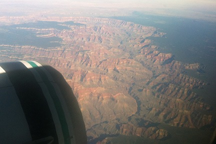
This is what the Grand Canyon looks like from an airliner. And yes, I’ll admit it: I actually took this photo on the way home from Seattle in September.
The flight was uneventful. The only item of note is the pilot or first officer who acted as a tour guide throughout various portions of the flight. I’ve never heard a pilot provide so much information about what was out the windows. We flew near or over the Grand Canyon, Bryce National Park, and, of course, the mountains south of Seattle: Rainier, St. Helens, Adams, Hood. I was on the right side of the plane and felt a surge of homesickness when I spotted the Columbia River basin near Quincy. I also caught sight of the smoke from the fires that were still burning between Wenatchee, Cashmere, and Ellensburg. The air over the Columbia, however, was much clearer than it had been on the day I’d left three weeks before.
At SeaTac, I needed to meet up with my co-pilot for the return trip, Ronnie. Ronnie is a pilot who used to live in Arizona but now lives in Colorado. She’s a flight instructor who mostly flies Schweizers these days, but she’s checked out and endorsed in R44s. I’d asked her to join me on the return flight to Phoenix because I was worried that I might be too tired to make the flight alone. I haven’t been sleeping well for the past few months and would likely be doing a lot of flying on Saturday, before our planned afternoon departure. Her flight landed right after mine. We texted back and forth and finally met up near her gate. We’d take the same flight together to Wenatchee.
We arrived in Wenatchee on time at about 3:30 PM. We walked to the general aviation terminal, where the truck I used all summer was parked and waiting for my return — with the luggage I’d packed three weeks before for my return trip. It started right up. We stowed our bags and drove it out onto the ramp. Then I peeled off the helicopter’s blade hail cover and cockpit cover and tossed them into the back of the truck. We unloaded all the gear I’d left in the helicopter and stowed it in the truck, moved the truck off the ramp, and went back out to the helicopter. I wanted to make sure it started — I hadn’t flown it in over three weeks — and top off the tanks with fuel. It seemed like a good idea to take Ronnie for a quick flight around the area.
I preflighted, we climbed aboard, and I primed the engine. When I pushed the starter button, the helicopter roared to life as if to say, “Where the hell have you been? Let’s go flying!” A few minutes later we were airborne, heading southwest.
I showed Ronnie the orchard I’d been based at for the end of the season and the now-empty RV pad my host had built for me near his home. Then we popped over Wenatchee Heights and headed out to Malaga. I showed her my friend Al’s winery and the 10 acres of view property I hope to buy in January for my new home. Then we crossed the river, hovered momentarily near the tasting room for Mike and Judy’s winery, and went in for landing at the pumps at Wenatchee Airport. As we were coming in, another helicopter pilot got on the radio and welcomed me back.
(I should mention here that I was supposed to stay in Washington until October. I’d been working on a video project for another one of my winemaker friends. In April, when I brought my RV up from Arizona, I’d videoed the bottling process. I was supposed to video the late September pick and crush at several of the wineries. But things back home had become so uncertain that I simply had to return to check things out. And although I had every intention of coming back to Washington to do the video work I planned, what I found at home convinced me to stay. Thus, I missed out not only on getting the video work done, but I also had to turn down at least a dozen charter flights and winery tours that probably would have been good for about $10K in revenue.)
We fueled up the helicopter and I repositioned it on the ramp. By that time, my friend Jim was about 20 minutes out with his helicopter. Jim also flies an R44. He’s based in Coeur d’Alene, ID and operates Big Country Helicopters there. Like me, he’s a cherry drying pilot. During the summer, we’d arranged to work together at the Wenatchee Wings and Wheels event at the airport on Saturday, October 6. We’d be doing helicopter rides for $35/person. Jim had brought along his wife and another ground crew person. Ronnie would also help out during the event.
Jim arrived and parked beside me on the ramp. We then set about stowing all the helicopter gear from the truck in the general aviation hangar so I could squeeze the five of us in the truck for the trip into Wenatchee.
We got rooms at the Coast Wenatchee Center Hotel, which was quite nice. Ronnie and I shared a room, not only to save a few dollars but because it was the last available room in the hotel. Jim had reservations; we didn’t. We were pretty lucky to find a room at all because of a big event going on in Leavenworth, about 20 miles away.

I think this sign says it all about the Rivertop Bar and Grill.
We had dinner at the Wok About Grill. Jim and I are still dieting; Mongolian Barbecue makes it easy for us to pick and choose exactly what we eat. Later, we went up to the top floor bar in our hotel for drinks. While we were there, a DJ came in, started playing a weird mix of music, and turned on one of those disco balls. We left before the Karaoke began.
Saturday: The Big Event
Of course, I slept like crap. It’s difficult to deal with insomnia when you’re sharing a room with someone else. There are limits to what you can do without waking the other person. I spent a lot of time reading and doing social networking on my iPad. By the time 6 AM rolled along, I’d had about four hours of sleep. I hopped in the shower, dressed, and put on some makeup. By that time, Ronnie was half awake. I left her at 7 AM with a promise to be back my 9:00 to take everyone back to the airport. I had things to do and people to see.
My first stop was up in Wenatchee Heights, at the house where I’d parked my RV in late August and early September. The house belonged to my friend Mike, who had agreed to store my motorcycle for the season in his garage. I needed to retrieve my Moitek video camera mount. I wanted to bring it back to Arizona with me so I could do video flights while I was home during the winter months. I unlocked the house and dragged the two Pelican cases to the garage door where the truck was parked and waiting. But I could not lift the larger of the two boxes by myself. I needed help.
So I called Steve, the next door neighbor. He’s building a garage with an apartment on top for retirement and he was there and awake. A while later, he was helping me lift the two boxes into the back of the truck.
Next, we needed to make sure that the truck fit in Steve’s garage. I’d made arrangements with him to store the truck there over the winter. His garage has three bays and solar heat. He’d graciously agreed to let me park the truck there, out of the elements. In return, I told him he could use the truck for any Home Depot runs he needed to do. After measuring the garage bay and the truck, I drove it in. It fit with about 3 feet of space to spare.
Steve gave me a cup of coffee and we chatted for a while. His upstairs apartment is coming along nicely. He’s a really nice guy — hell, all of the people I’ve met in Washington are really nice — and I really appreciated him helping me out with the truck.
Then I was off to my next meeting: a visit with Alex the Bird and the folks who have agreed to take her for the winter.
When I knew I had to leave early to check on things back home, I arranged with Leah and Freddy, who live on the orchard, to watch Alex the Bird. Even though I planned to return, I suspected that bringing Alex home with me would not be a good idea. It would complicate matters that were already likely out of control. So I asked them if they’d take her for the winter. Not only did they say yes, but they were excited about it. With two kids, a dog, and a cat, I knew their home would be a great environment for Alex. I also suspected that Alex would entertain them.
I rang the bell at 8 AM, as scheduled. Alex was in her cage in the kitchen where she could watch everything going on. She looked happy — but cautious — about seeing me. Our past year together — which included living in my husband’s Phoenix condo — had not been good. Alex hated the condo, maybe even more than I did. Not only was her space there dark with nothing going on to keep her entertained, but I spent long hours in my office, working on various books. Her winter molt had lasted far longer than it should have — an indication to me that she wasn’t happy. Even when we got back to Washington and she was staying in her favorite cage, I could tell that things were different with her.
In talking with Leah, I got the impression that she was happier with Leah’s family than she had been with me over the past year. It made me both happy and sad. And Leah was still enthusiastic about watching her. She told me about how much Alex kept them entertained. And she apologized about Alex learning the word “crap” from her son. I left them after a half-hour visit that included filling Leah in on what had gone on at home in the past three weeks. She, like everyone else, was extremely sympathetic and supportive.
I was back at the hotel at 9:15. Everyone climbed aboard and we headed up to the airport. The event was just beginning, starting with a pancake breakfast. We went out to the helicopters, removed the tie-downs, and preflighted. We already had several people waiting to fly. Because of the cold overnight temperatures, Jim needed a little help from the local mechanics to get his helicopter started. So I started up and started doing rides. I was just coming back from my second ride when Jim was spinning and ready to take on his passengers.
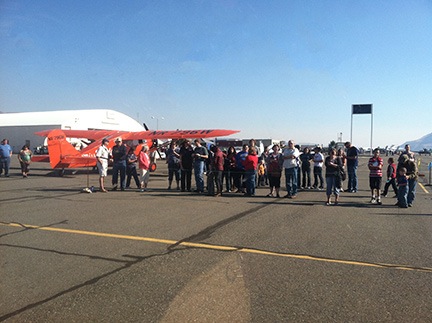
The view from my seat as I waited for the ground crew to load passengers. The orrange-red plane in the photo is operated by the Spirit of Wenatchee. It’s a reproduction of the Miss Veedol, the plane Clyde Pangborn and Hugh
Herndon Jr. used to cross the Pacific Ocean in 1931.
We flew from 8:30 AM on. Our ground crew was excellent — no whining! Jim’s wife took the money and kept track of how many each of us flew. Ronnie did the safety briefings, using one of my safety briefing cards. Then Ronnie and Marshall loaded and unloaded the passengers. Jim and I worked hard to time the flight so only one of us was on the ground at a time. It was a constant flow of passengers for our 6- to 8-minute flights. The only time we stopped was for fuel: Jim first, then me a while later, and then Jim again.
Time flew. The event was supposed to end at 3 PM, but people were still lined up for flights. When Jim went for fuel around that time, I told him I’d keep flying until he was ready to fly again. Then Ronnie and I needed to leave. The plan was to top off the tanks, reload the gear, and get down to John Day Airport in Oregon before nightfall. But as time ticked on, that seemed less and less likely. Even when the tanks were topped off and we started loading our gear, I was doubtful about reaching John Day before dark. Sunset was just after 6 PM and it was already after 4 PM in Wenatchee.
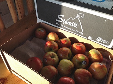
The remaining apples, once I got them home. I’ve been eating them every day since and have given away a bunch more. Thanks, West!
Meanwhile, my favorite Wenatchee area client stopped by with a 40-pound box of Honey Crisp apples, picked only days before at one of the orchards we’d landed at quite often during the summer. I realized immediately that the box would take up too much space in the helicopter. So I gave away about half the apples to the mechanics at Wenatchee airport and to Jim and his crew, then cut the box down to half size to get the remaining 20 pounds home. The box was still a lot bigger than I needed it to be, but there was no way I was going to part with any more of those apples.
We struggled to get the Moitek boxes into the helicopter. Although we managed to get the big one in, it left very little room for the rest of the things we needed to take. I started getting stressed, probably because of the long day of flying and my general lack of sleep. I made two big decisions: (1) leave the Moitek behind and (2) start the flight home in the morning. Ronnie agreed.
In the meantime, Jim was just finishing up. He planned to fly back to Coeur d’Alene that night. It was about a 90-minute flight for him and he knew the area well. We repacked my helicopter and repositioned it for the night. Then we saw Jim and his party off and headed back up to Wenatchee Heights to store the Moitek back in Mike’s house.
Ronnie and I were both exhausted from the full day. We knew we’d have to leave Wenatchee very early in the morning to make it to Phoenix in time for Ronnie’s 5:55 PM flight to Denver. We got a room at an East Wenatchee hotel I’d stayed at before and tried to grab a quick meal in the restaurant behind it. Service sucked and we spent way too long there. Ronnie got a sandwich and I took the other half of my salad to go for the next day. We wouldn’t have time to stop for lunch; there would be in-flight meal service on our helicopter flight.
We were in bed and asleep by 9 PM.
Sunday: The Cross-Country Flight
It should come as no surprise that I slept like crap. I was up for hours in the middle of the night with my brain operating at light speed. My biggest worry: what was going on at home with me gone. My husband had become an irrational stranger over the summer and I honestly didn’t know what he was capable of anymore. Of course, I fell back to sleep around 4 AM. So when Ronnie’s alarm went off, it woke me up, too.
I grabbed a quick shower, dressed, and was ready to go within 30 minutes. It was still dark out with no sign of dawn when we got to the airport at 5:30 AM. It was cold, too. I’d dressed in a long-sleeved shirt and one of my Flying M Air denim shirts and a jacket and was still chilled. I preflighted with the help of a flashlight while Ronnie installed the dual controls. We lifted off at 5:50 AM as the sky began to brighten in the east.
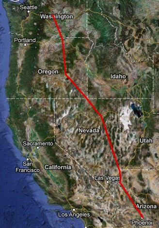
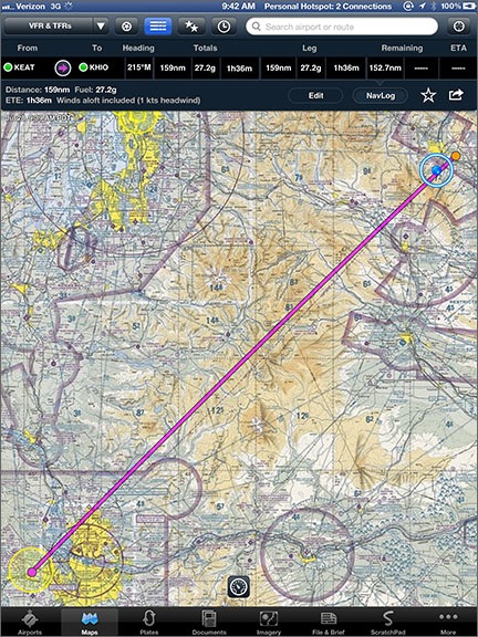
The actual track from our route, plotted on a map. The kinks in the route were to fly around restricted or otherwise controlled airspace.
We were going the most direct route, which should be about 9 hours of flight time. We needed three fuel stops: Burns, OR; Elko, NV; and Mesquite, NV. Although I wanted to land in Wickenburg and drive Ronnie to the airport, it didn’t look as if we’d have enough time to do that. I’d evaluate the situation when we got to Mesquite; I was prepared to land her at Sky Harbor, just as Don had done for me two days before.
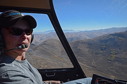
Ronnie at the controls over Oregon or maybe Nevada.
The sun came up when we were just south of Hanford. We crossed the Columbia River near Hermiston to voice the restricted area west of there. From there, it was a straight shot to Burns. Ronnie did most of the flying, but I landed us at Burns because I knew where the fuel island was. We got there in good time. The place was deserted, but fuel was self-serve. I had the grounding strap connected before the blades had even stopped spinning. I don’t think we were on the ground more than 15 minutes. Then we started up and took off to the next stop.
The stretch between Burns and Elko crosses over some of the most remote, empty desert I’ve ever flown over. In the spring, the area is home to many large herds of wild horses. But in the fall, with most of the grass gone, there isn’t much life at all. We didn’t see a single horse — and believe me, I looked.
Fall foliage near Elko, NV from the air.
Again, Ronnie did most of the flying. I had my Nikon out and took a few pictures. Just a few because I really hate photos with glare in them and it’s nearly impossible to get glare-free photos through Plexiglas. We saw some pockets of fall color along the way. In some areas, it was quite beautiful.
We landed at Elko, where they have a great FBO. The line guy fueled us from a truck while we went inside to use the restroom. I also bought some oil — I’d been adding at least a half-quart at each stop — and bottled water. We were on the ground less than 30 minutes. Then we were airborne again, continuing southeast. It was about 11 AM. We were doing excellent time.
We ate our lunches, one at a time, just after leaving Elko. Ronnie went first while I flew. Then I went. Yes: I admit that I stole a fork from the restaurant. We’d kept the food cold in a little cooler I’d left in the helicopter just for that purpose; my salad was even better the second day.
We may have been doing good time, but it wasn’t good enough to land at Wickenburg and drive to Phoenix. That became clear as we neared Mesquite, NV. Even though we were on the ground there less than 20 minutes, we had at least 2 hours of flight time ahead of us. While it might be possible to land and drive to Sky Harbor in time for Ronnie to make her flight to Denver, there wouldn’t be time to stow the helicopter in the hangar before that. And with things as weird as they were back in Wickenburg, there was no way I would leave my helicopter out in the open without keeping an eye on it.
We skirted around the Grand Canyon airspace south of Mesquite, listening to the tour pilots on the radio talking about reporting points we didn’t know. I made a few position calls in relation to Meadview. As we climbed over the cliffs near Grand Canyon West airport, just when I thought we were clear of the tour traffic, Ronnie spotted another helicopter a little too close to our location for comfort. The other pilot must have seen us, too, because he took evasive action before we could.
Later, near the Weaver Mountains, I took control from Ronnie again and gave her a low-level thrill ride through the canyons that led to Lake Pleasant. It’s something that I usually do alone, but since Ronnie had commented on canyon flying earlier in our flight, I thought I’d give her a taste of what I do when I know the terrain very well. I admit that I’m spoiled: being able to fly where I like is something that most pilots who work for someone else don’t get to do.
It was around 4 PM when I made my radio call to Phoenix Tower. Ronnie used her camera to video our approach and landing on the helipad. (She put it on Facebook but I think access is restricted to her friends.) She climbed out and grabbed her bags. I watched her clear the helipad, then called for departure and headed north to Deer Valley. I’d need to buy fuel to get back to Wickenburg.
I took a nice rest at Atlantic Aviation, had some cold water, and chatted with the girl working the desk. Although I’d been shedding layers of clothing on every stop, I was still wearing jeans and a long-sleeved shirt in 90+° weather. But I felt remarkably refreshed when I headed out for the final leg of my trip to Wickenburg. Once I cleared the subdivisions and the power lines near Lake Pleasant, I dropped down low over the desert, speeding northeast. It felt good to be back in familiar territory.
But I also felt sad. I knew my days in Arizona were numbered. How many more times would I cross that familiar stretch of desert between Phoenix and Wickenburg? I didn’t know. One thing is for sure: I’m determined to enjoy every single flight.
I touched down at Wickenburg at 5 PM. By 5:30 PM, the helicopter was secured back in its hangar and I was heading home.
We’d shattered my previous record for the flight, completing it in about 9 hours of total flight time.
 The road to Lockett Meadow is not paved. I was driving my Honda S2000, which probably has about 6 inches of clearance on the bottom. (At least it seems that way.) I was a little concerned when I saw the sign that said “Road Not Maintained for Passenger Vehicles,” but when you consider that the road to my house is not maintained at all and is currently in deplorable condition and I drive it every day with the Honda, I was willing to give it a try.
 Lockett Meadow Campground was at the end of the road. So were the aspen groves. I stopped and snapped a few photos, including this shot of my car parked alongside the road.
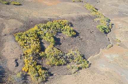
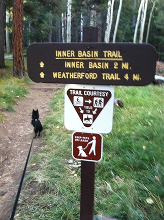 In the back of the campground was the trailhead for the Inner Basin trail. I parked the car among the SUVs in the small lot and got out with Penny to take a look. The trail looked dark and wound into the forest. It didn’t look very inviting. Although Penny was ready to go, it didn’t look like the kind of hike I wanted to take early in the morning. I was more interested in photographing the aspens; there were plenty of subjects back out in the meadow.
 I love including reflections in my photographs. This location did not disappoint me. I was able to make a number of photographs that really showed off the view with perfect reflections.
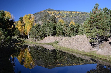 I got back into the car again, now ready to leave. But again, as I was driving off, I caught sight of another place where still water was surrounded by trees. Leaving Penny in the car, I went to investigate and made a few more reflection photos. It was really much more than I had hoped for.
 When Rod and I finished talking, I felt better. Penny and I got back into the car and continued to the Snowbowl. We followed the winding road all the way up to the entrance to the ski area. Just to the right was the parking area for the trailhead.
 Like the other trail, the Kachina trail led into the woods. But whether it was the time of day — after 10 AM — or just the kind of trail, it seemed a lot brighter and more inviting. But what really surprised me was the elevation — the GPS in my phone reported nearly 9,300 feet. Whoa.
 The trail was relatively narrow and wound up and down through the forest, between trees and around large rocks. Penny, on her leash, led the way, stopping occasionally to sniff at something. We met a young family with children walking the other way. I kept up a good pace without getting winded, despite the elevation, and was glad again for the health benefits of my recent weight loss.
 On the way up to the Kachina Trail, I’d passed a place called Aspen Corner. There was a parking area there with paths through an aspen grove. Those trees were at near peak color. I decided to wander around there for a while.
 Penny and I wandered around for a while. I asked another photographer to take a photo of usy, but the exposure was so bad you can barely see us. I also tried a self-portrait using the camera’s timer and did a little better — although I’m squinting into the sun so badly that I don’t really look very appealing. Oh, and do you know how difficult it is to prop up a DSLR vertically on a log?
 I can’t really express the joy I feel driving a tight-steering sports car with plenty of performance at high speed on otherwise empty mountain roads. Two weeks ago Sunday was the first time I’d driven my car since leaving Arizona in early May. A few trips to Phoenix helped reacquaint me to its feel. But this Sunday, as I sped toward Sedona, we were fully reacquainted. I especially enjoyed the stretch of Highway 89 in the Prescott National Forest between Wilhoit and Prescott. The stretch of Highway 89A between The Yavapai Country Fairgrounds and Jerome would have been even better if I weren’t stuck behind a slow Prius for most of the trip.
 The
The 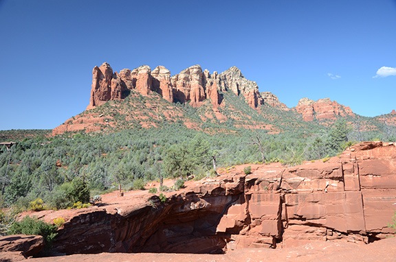


 Wikipedia image. (No, it’s not me. Sheesh.)