Tips for Flying at Lake Powell: Lake Powell and the Airports

The first of a four-part series about flying at Lake Powell.

I’ve been at Page, AZ on the dam end of Lake Powell for about a month now. Although I already knew quite a bit about flying at the lake from numerous photo jobs here, I’ve picked up quite a bit in the past month, mostly from my pilot neighbors at the campground. Since I have enough material to blog about it, I figured I’d write about it, mostly to get my mind off politics and the tech book I’m working on.

Anyway, this will be a four-part series and this is the first part. I have notes for the other three parts, so I’m sure I’ll get them done — probably within the next week or so.

About Page and Lake Powell
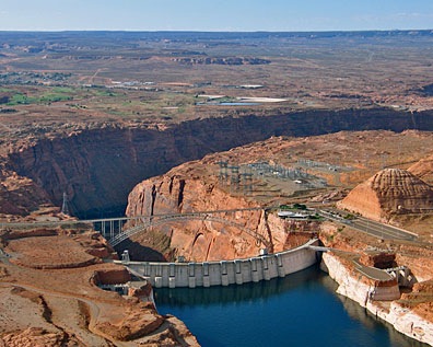
Glen Canyon DamPage is the town built in the late 1950s to house the workers on the Glen Canyon Dam, which was under construction at the time. It sits atop a mesa to the east of the Colorado River. The current population of the town is about 7,000, but it attracts approximately 3 million visitors a year.

The dam was completed in 1963 and water began collecting behind it in what would become Lake Powell. It took 17 years for the lake to reach its high water mark at 3,700 feet elevation. Since then, the water level has fluctuated considerably over the years. As I type this, the water level is at 3,629 feet, a full 71 feet below full pool. Around the water line is a tall white line: the so-called “bathtub ring” that marks the high water line.
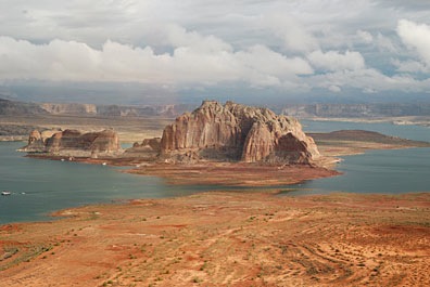
Lake Powell with CloudsLake Powell is outrageously beautiful. Its clear, blue water reflects the clear Arizona/Utah sky. Its red rock canyons, buttes, and other formations change throughout the day with the light. Deep, narrow canyons cut into the desert, making mysterious pathways for boaters to explore. When the wind and water is calm, the buttes and canyon walls cast their reflections down on the water. In the rare instances when weather moves in, low clouds add yet another dimension to the scenery.

I love the lake.

Flying at Lake Powell

The best way to see Lake Powell is from the air.
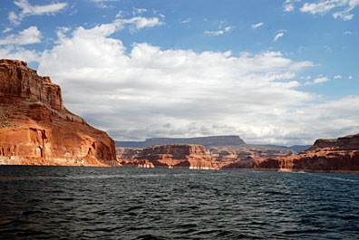
On the LakeSure, it’s wonderful by boat — especially by houseboat over 5 to 7 days with a bunch of good friends or family members — but views are limited from the ground and distances take a long time to cover. Let’s face it: the lake’s surface area is 266 square miles (at full pool) and it stretches 186 miles up the Colorado and San Juan Rivers. You could explore the lake by boat for a year and not get a chance to visit each of its 90 water-filled side canyons.

So if you have a plane (or helicopter) or feel like splurging on an airplane tour, you’ll get a special look at the lake that few people see. I highly recommend it.

[Air]Ports of Entry

There are technically four airports along Lake Powell. You can see them all on this pieced-together sectional. (The lake straddles the Las Vegas and Denver charts.)

Airports at Lake Powell

  • Page Municipal (PGA) is the main airport. It’s on east side of the mesa where the City of Page sits, and has two runways. Runway 15/33 is the more commonly used runway; it’s longer. But for strong crosswinds, there’s also 7/25, which does not have a parallel taxiway. There are two FBOs competing for the fuel business (AVFuel and BP). There are tie-downs and a mechanic on the field.
  • Bullfrog Basin (U07) is at the Bullfrog Crossing marina. I haven’t landed there (yet), but I’m pretty sure it doesn’t have any facilities. It does, however, have transportation to the marina, where you might be able to get lunch.
  • Cal Black Memorial (U96) is 10 miles from Halls Crossing. It’s a nice airport with a good, lighted runway and 24-hour fuel pumped by Maury, who lives there. (Maury’s getting over some surgery as I write this, but I hope he’ll be there if you stop in an visit. Tell him Maria with the red helicopter says hello.) There’s a shuttle to Halls Crossing, where there’s a lodge and boat rentals, during regular business hours.
  • Hite (UT03) is near Hite Landing. This is a very scary runway — narrow and perhaps slightly crooked — and it’s marked “hazardous” on charts. The last time I drove through the area in 2005, the Hite marina was high and dry and the area was deserted. It might be a bit more active now that the water level is up a bit.
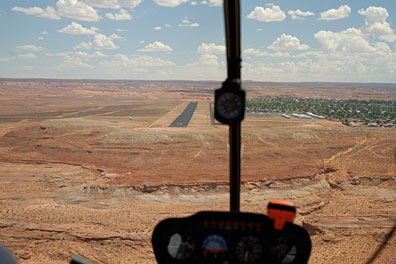
Landing at PGAMost people fly into Page, since it’s the only airport near a town. If you come in from the northwest and land on Runway 15, as we are in this photo — well, we’re actually lined up for landing on the taxiway — you’ll make your descent right over the lake, west of Antelope Marina. (The town is all that green stuff to the right.) Taking off on Runway 33 has you shooting out over the edge of the mesa and lake. Pretty dramatic stuff. I have a lot of fun with it since I don’t really “climb out” after takeoff. The airport is at 4316 feet and the lake is currently at 3629 feet, so there’s no reason to gain altitude if I’m just cruising the lake.

Cal Black has the distinction of being the closest fuel to Monument Valley — about 25 miles away, I think. I made quite a few fuel stops there on a 3-day photo job at Monument Valley and even flew in before sunrise one morning. (Scary stuff; there’s nothing else out there.) I don’t know enough about Bullfrog to provide any tips, but I’d recommend staying clear of Hite.

If you’re a helicopter pilot and think you can set down anywhere near the lake or on one of its islands or buttes, think again. Lake Powell is in the Glen Canyon National Recreation Area and off-airport landing is prohibited. If you’re caught doing it, you will get in serious trouble with the National Park Service and the FAA. I don’t think it’s worth it, do you?

Coming Up

In the next three parts of the series, I’ll cover the air tour operations, which all pilots flying in the area should be aware of. Then I’ll tell you about some points of interest on the lake. Finally, I’ll tell you what to expect if you fly uplake, beyond the Confluence of the San Juan.

Meanwhile, your comments are welcome here. I’m especially interested in hearing from pilots who have landed at one of the four airports along the lake. Save your tips about points of interest for Part III or IV.

Work: Feast or Famine

An empty summer packs up quickly.

Less than a week ago, on the morning of Friday, February 8, I was looking at a pretty empty summer season. I had one book contract lined up — an annual revision I usually work in in June and July — and no idea where or even if I’d be flying for someone else during the April through September timeframe I’d set aside for Alaska.

Two other books had been dangled in front of me on and off for the past two months. If I got them, they’d keep me busy from now until the summer time. But it didn’t look as if I’d get them.

And while I was hoping to spend the entire summer flying for someone else in Alaska, the recent demise of Silver State Helicopters dumped all of their CFIs (certified flight instructors) on the job market. If any of them had 1,000 hours (or said they had 1,000 hours), they’d be lined up for the few entry level jobs at the Grand Canyon, Gulf of Mexico, and Alaska. My experience level is a bit higher than entry level for those jobs, so employers would have to pay me more. Why pay for steak when hamburger will do? Despite four resumes out there in the land of the midnight sun, my phone remained silent. So it didn’t look as if I’d be going to Alaska after all.

And that was the state of things last Friday morning.

A Telephone Call Changes the Scene

I did have one other resume out in the wild: I’d sent it about a month before to an Illinois-based Part 135 operator. They were looking for a full time pilot to help them with a special contract and then do odd flying jobs as needed in the midwest. (And yes, I’m being purposely vague. Last week’s fiasco has put me into high caution mode.) I exchanged a few e-mails with the owner, who said that a contract pilot — which is what I’d prefer — might work out better for him. He told me to call him. I did, but never seemed to get him on the phone. I waited for him to call. He didn’t. I sent him an e-mail, asking if the job had been filled; if it had, I’d stop bothering him. He wrote back to say the job wasn’t filled, he was definitely interested in me, but he was swamped with work. He’d call. He didn’t. All this happened during the course of a month.

On Friday, I decided to call again. I wanted to either cross off this opportunity or bring it into the realm of possibility. I got the owner on the phone. We hit it off right away. I got the feeling he’d spoken to a few other people about the job and they weren’t interested in some of the more unusual aspects. (Again, I’m being vague on purpose; I don’t want anyone to screw this up for me.) I also got the feeling he was being inundated with resumes from Silver State casualties of Chapter 7 — guys who have earned their 1,000 hours in a simulator or as an active passenger during dual instruction flights. He wanted someone with experience flying passengers for hire, which I’ve been doing since 2001. We joked around a little. He told me that mid-month, he would fly me up to his base for a face-to-face meeting and a chance for me to see their equipment. I assume a flight would also be part of the interview process.

I hung up the phone feeling good. This opportunity had gone from a long shot to a 75% or more chance of getting the job. And without going into details, I can assure you that the job will be very interesting, with plenty to blog about — if I’m allowed to.

Two More Calls, Three More Books?

Product ImageMy phone rang on Monday morning. It was one of my editors. He’s been swamped since the holidays and has just dug out of the pile of work on his desk. He pulled one of the dangling books out of the air and slapped it on the negotiation table. We talked terms, we agreed. (My co-author on the book agreed yesterday.) I’m looking for a contract in the mail any day now. Time frame? Well, the book is already listed on Amazon.com, so I guess I’d better get to work on it soon.

He also dangled that other book around some more, but no decision was made. We didn’t even talk terms. So although I can’t count on it yet, it’s definitely still in the picture.

Yesterday, I got another call from another editor I work with regularly. She flat-out offered me a book deal with terms that would be tough to turn down. So I said yes. The contract should come within the next week or so. Timeframe: late summer. Sorry; no details will be forthcoming anytime soon.

What’s good about all this is that I have enough writing work lined up to support me through the summer, when Flying M Air continues to incur expenses but does not incur much (if any) revenue.

Another Call with another Flying Possibility

Between the two editor calls, I got a call from a California-based Part 135 helicopter operator. They’d seen my helicopter forum post that had a subject line like “Single Pilot Part 135 Operator with Helicopter Available for Summer Months.” This guy is interested in expanding his business to offer a major city’s commuters with helicopter transportation into that city from the suburbs. (Yes, I’m being vague again; jeez, I hate this.) Rather than invest in a lot of equipment and train pilots, he thinks we might work together with me and my helicopter subcontracted by his organization to provide the flights. If things work out, he’ll expand; if they don’t, no serious money lost.

While this is very interesting to me, I’m worried that there won’t be enough revenue in it to support me and my aircraft. After all, I’d have to relocate for the entire summer and the city in question ain’t exactly cheap to live in. But it is a really nice city, one I wouldn’t mind living in at all. I told him about my other opportunity and how I wanted to pursue that first. He said that if that job didn’t work out and I was still available, I should call him in a month or so to talk about flying for him.

I’m calling that “Summer Job Plan C.”

Plan D, I should mention, is cherry drying in Washington State, which, as usual, is always dangling out there but never quite attainable.

Today

My helicopter calendar has a few — but not many — things on it. I’ll be doing rides at the Buckeye Air Fair again on Saturday. I picked up a Sky Harbor Charter for March with some folks who already told me they want another day trip when they come to Wickenburg. And I have a Wickenburg area tour prebooked through a tour company for March 1.

The Southwest Circle Helicopter Adventure simply is not selling. It could be my limited marketing budget. But I can’t see paying $10-$15K for a magazine advertisement if it’ll take the sale of more than 10 excursions just to pay for the ad. (The trip really is a smoking deal and I don’t make much money on it.)

But I do have some possibilities on desert racing aerial photography gigs lined up for March and April. We’ll see how that goes. The ferry cost is hard for most of those companies to swallow. I’d do a lot better with race photography gigs if I’d relocate to Lake Havasu or Bullhead City. (And believe me, I’m thinking about it.)

Today, I’m finishing up an article I started on Monday for FileMaker Advisor magazine. Then I’m going to work on my outline for my half of our WordPress book revision. If I finish that before the end of the day, I’ll finish up my series of articles about using Viddler with WordPress. And maybe — just maybe — I’ll record another video blog entry.

But only if I can do something with my hair.

I Don’t Like Being Seriously Dugg

The activity finally winds down — I think.

In yesterday’s post, “Getting Seriously Dugg,” I reported the history of a blog post that rose quickly to stardom in the world of Digg users. But that report was done early in the day, before the shit hit the fan (so to speak).

The Heat is On

The Digg count continued to rise throughout the day. And the hits kept coming. All morning long, there were at least 100 visitors online at my site at once. This is not normal here. And it was rather frightening. I kept expecting something to break.

But it wasn’t just the popular Digg post that was getting hits. It was the post about getting Dugg, too. Soon, it had more hits than the dugg post — even though it wasn’t dug by anyone at all. I’m still trying to figure that one out.

Things came to a head at 11:15 AM when I got an e-mail message from my ISP:

Our Hosting Operations Admins have alerted us to an issue with your hosting account. The account has overutilized resources within the shared environment. As a result, the account has been moved to an isolated server for Terms of Service violators. You have 30 days to research and resolve this issue. After this time, the account will be evaluated again. If the issue is resolved, the account will be migrated back to the shared environment. If it persists, you will need to move to a full Dedicated server.

I got on the phone immediately and called my ISP. To my knowledge, I hadn’t violated any terms of service by getting hits. My plan allows 2,000 GB of bandwidth per month. The billing month starts on the third — that day. So far, in all the years I’ve hosted there, I’ve never exceeded 6% of my monthly allowance. Just because I was getting 30 times the usual number of hits I get in a day, it was still not much more than I’d get in a total month. So there was no way I’d even come close to 10% of the monthly allowance — let alone exceed it.

The guy who answered the phone was extremely polite but equally clueless. He had to talk to Advanced Hosting. He couldn’t let me talk to them. They gave him a song and dance about too many domain names pointing to the same site. He attempted to hand the same thing to me. I told him that that shouldn’t matter since none of those domain names were advertised anywhere. Besides, there were only about a dozen of them pointing to one site and maybe 15 pointing to another. I wasn’t aware of any limitation.

“I’ve been dugg,” I told him. When I got no answer, I asked, “Do you know what that means?”

“No,” he said.

I explained that it meant that one of my blog’s posts had become very popular and that people were flocking to my site to read it. I told him this was a temporary thing and that it should be back to normal by the end of the day. I hoped.

He told me that if I continued to get so many hits to my site, I’d have to get a dedicated server. I told him I’d evaluate after I’d seen my stats for the day. (My account is updated daily in the middle of the night.)

We hung up.

A Brief Intermission

I went flying. I took a couple from Virginia on an hour-long helicopter tour in the Wickenburg area. I showed them mine sites and canyons from the air. We saw a lot of cows, too. Afterward, I goofed off at the airport, chatting with two jet pilots who’d come in and were waiting for passengers. Then I went shopping for dinner. I got home and had a snack. Then I looked at Digg. It was 4 PM.

What Happened in Five Hours

The post that had started it all now had more than 1,200 diggs. It had been viewed almost 30,000 times. The post about that post, which hadn’t been dugg at all, had been viewed more than 40,000 times.

But thankfully, there were only 33 people online. So the flood had begun to subside.

On the Digg Technology page, my dugg post was listed near the bottom, under newly popular. (Ironically, on the same page, near the top, was a post about how Digg was losing popularity. That had more than 1,200 diggs, too.)

The Morning After

It’s the next day. I can now look back objectively on my blog’s day with a Digg Top 10 Tech post by studying some of the stats for the day and how the differ from other days.

My ISP reports that for the first day of my billing period — yesterday — I used up .55% (that’s just over half a percent, folks) of my monthly bandwidth. That means that if every day was like yesterday, I’d still come in at less than 20% allowable bandwidth. So I don’t know what “terms of service violation” they were whining about.

W3Counter, which I use to track page hits and visits, says I got just over 27,000 page hits yesterday. Look at the chart below; it makes my site look flat-line dead before yesterday. Honestly — it wasn’t that dead.

Hits

Today’s hits are about 3 times a normal day. Nice, but I’m willing to bet it drops down to normal within the next few days.

W3Counter also sent me an e-mail message warning me that their free service doesn’t cover sites that get more than 5,000 hits a day.They say I need to upgrade to a pro account for $4.95/month. We’ll see how long before they disable my current account — I’m not paying them to tell me how many hits I get when I can easily set up some stat software with a free WordPress plugin. (ShortStats, which we wrote about in our WordPress book, comes to mind.)

(I have not been able to reconcile page hits as reported by W3Counter with article reads as reported by a WordPress plugin. I have a sneaking suspicion that the WordPress plugin counts bots.)

Digg, as a source of hits, kicked Google out of the top spot on my site. Google used to account for 54% of my visitors. Now, for the 14-day period tracked by W3Counter, Digg is the big source. Google doesn’t even make the list any more, with all the different Digg URLs people used to find my site. So my sources stat is completely skewed and pretty much useless for the next 13 days. And 93% of the hits in the past 14 days have been to the 18-year-old mouse story.

Meanwhile, WP-UserOnline reports that yesterday saw the most users online at once on this site: 375. I don’t think this site will ever see that many concurrent users again.

My RSS feed subscriptions have more than doubled. That’s great. (If you’re a new subscriber, thanks for tuning in. And don’t worry — I don’t write about Digg every day.) It’ll be interesting to see if that number continues to climb or if I manage to scare all the new folks off by failing to provide more Diggable content on a daily basis.

My Google AdSense revenue for yesterday was right in line with an average high day. When you consider that I got about 20 times my normal number of page hits yesterday, you might think that I’d get 20 times the revenue. I didn’t. Obviously, Digg users don’t click Google ads.

The last I checked, the 18-year-old mouse story got just over 1,357 Diggs. I think that I actually encouraged the extra Diggs by placing the Digg icon at the top of the post. I’ve since taken it away from all posts.

I’ve realized that I don’t want to be seriously Dugg. Other than the surge in new RSS subscribers, there really isn’t any benefit to it.

What do you think?

Have you been slammed by being dugg? How did it affect your hosting account or other services? Use the Comments link or form to let the rest of us know.

Could it Be? Monsoon Season?

Heat’s not enough. I want humidity and rain, too.

This morning, when I woke at 5:30 AM to the whistles of my parrot, I was surprised to see that Mike hadn’t opened the French door between our bedroom and the upstairs patio. He always opens it during the night this time of year. That’s the only time it’s cool.

But when I opened it, I realized why: it wasn’t cool. For the first time this season, the outside temperature remained in the 80s overnight. And that’s the first sign of what everyone in Arizona is waiting for this time of year: monsoon season.

A Monsoon? In the Desert?

Sure. I can’t make this stuff up.

Monsoon season in Arizona is marked by a number of meteorological events:

  • Dew point reaches at least 55°F for at least three days in a row. That’s the official indicator of the start of monsoon season in Phoenix. That means it gets humid outside. The “dry heat” isn’t so dry anymore.
  • The winds shift to bring moist air off the Sea of Cortez and Gulf of Mexico in a counterclockwise flow. This is why the storms, when they come to Wickenburg, come from the north or east during monsoon season.
  • My WebCamStorms build just about every afternoon. I can see them coming from my office window. (You can check out the WebCam image here; it’s usually available during daylight hours.) They’re isolated, severe thunderstorms, packed with high wind, lightning, and the occasional microburst.
  • It rains. That’s if we’re lucky. The clouds have lots of moisture, but if the ground is too dry, the rain dries up before it hits the ground, resulting in virga and, often, dust storms. But once monsoon season is underway, we get rain — although never enough of it to quench the thirst of our golf courses and swimming pools.
  • We get flash floods. That’s if we get enough rain all at once. A dry wash runs through our property and, with enough rain, it can turn into a raging river. For about an hour. Then it’s just a wet riverbed that, within 24 hours, turns dry again.

Want more info, you can get it here, here, and here.

And this is what most Arizonans are waiting for.

My Monsoons

I’ve experienced Arizona monsoons in three different places over the years.

Wickenburg
I’ve lived in Wickenburg for ten years now, and although I’ve been wanting to escape, like the snowbirds, in the summertime, I haven’t usually been able to. That means I’ve lived through a good bunch of monsoon seasons.

My office has always faced the mountains to the north (even when it was in a condo I own downtown). I’d be sitting at my desk, working away, occasionally glancing up out the window. I’d see the storm clouds building over the Bradshaw and Weaver Mountains, making their way southwest toward Wickenburg. The sky would get dark out there — while it remained sunny at my house — and lightning would flash. If the storm reached us before sunset, we were in for it. But in too many instances, the storm was just too slow and got to us after the sun set. Then it was a 50-50 chance that we’d get some storm activity — including welcome rain — before the storm dissipated.

Sometimes, the storms moved in more quickly — probably more moisture in the air. In those cases, we’d get a storm in the afternoon. What a treat! I’d stand under the overhang by my front door or on the patio at the condo and listen to the rain fall. Sometimes, if it looked rainy enough to get the washes flowing, I’d jump in my Jeep and head out into the desert, looking for a stream where streams don’t normally appear. I don’t drive through these — mind you — that’s dangerous. I just watch all that flowing water, remembering what it was like to live in a place where flowing water is a lot more common than dry streambeds.

On very rare occasions, a storm would move in just before dawn. I can’t remember this happening more than a few times, though. One time, it was the morning I was supposed to report back for work at the Grand Canyon, where I was flying helicopter tours. I had planned to take my helicopter up — the 1-1/2 hour flight sure beat the 3-1/2 hour drive. But with a thunderstorm sitting on top of Wickenburg, flying up was not a safe option. So I had to drive. I left two hours earlier than I would have and still got to work an hour late.

If you want to read more about the monsoon in Wickenburg, I recommend Lee Pearson’s excellent article for wickenburg-az.com, “The Monsoon Is Near“. It includes links to video footage he’s made available online.

Grand Canyon
In the summer of 2004, I worked as tour pilot at the Grand Canyon. I flew Long Ranger helicopters over the canyon 10 to 14 times a day on a 7 on/7 off schedule from April through the end of September.

My introduction to monsoon season came on my return from a flight in July. The storms had built up and were moving in toward the airport. I was about 5 miles out when a bolt of lightning came out of the sky less than 1/4 mile from where I was flying and struck the top of a Ponderosa pine tree. The treetop exploded into flames. I got on the radio, on our company frequency, and said, “It’s lightning out here. It just hit a tree about a quarter mile away from me.” The Chief Pilot’s voice came on and said, “Better get used to it.”

When you learn to fly, they teach you the danger of flying near thunderstorms. They advise you to stay at least 20 miles away. 20 miles! So you can imagine my surprise when I realized that the tour company had no qualms about continuing flight in the vicinity of thunderstorms.

And they were right — it didn’t seem to be dangerous at all. The storms were all localized — you could see them coming and usually fly around them if they were in your way. The rule we used was that if you could see through the rain, you could fly through it. Although it occasionally got a little bumpy, there were no serious updrafts or downdrafts. And although we were told that if things ever got too rough during a flight, we could land until the storm passed, I never had to. (Thus passing up my only opportunity to legally land a helicopter inside the Grand Canyon.)

The Grand Canyon with CloudsI do recall one other monsoon-related incident, though. The company I worked for had about ten helicopters on duty to do flights. Because of this, the company was very popular with tour companies, which would bus large groups of foreign tourists to the airport for helicopter flights. These flights were booked years in advance, so the company always knew when they’d need all helicopters to fly for a single group. One of these groups arrived late in the day during August. Nine other pilots and I were sitting out on our helipads, engines running, blades spinning, when the bus pulled up. Moments later, the loaders were bringing groups of five and six Japanese tourists to the helipads and loading us up.

It had been stormy most of the afternoon, with isolated thunderstorms drifting across the canyon. Farther out to the east, a controlled burn was sending low clouds of smoke our way. At the airport, however, the visibility was fine. We were scheduled to do a tour on the west side of the canyon, in the Dragon Corridor. One by one, we took off and headed west, making a long line of ten helicopters, all going the same way.

I was about six back from the front and could see we had a problem about five miles short of the rim. The north end of the Dragon Corridor was completely socked in with low clouds and falling rain. We couldn’t see across the canyon.

The lead helicopter announced on the company frequency that he was going to switch to an east canyon tour. He made a 180° turn. One by one, we all announced the same intentions and followed him. Now we were all heading back to the airport. We got permission from the tower to transition to the east, crossed about 1/2 mile south of the airport, and continued on.

Now we were in the smokey area. It wasn’t bad. Not yet, anyway. We crossed over the canyon and my passengers let out the usual oohs and ahs. And we proceeded to do the east canyon tour, which was reserved for weather situations because it normally ran about 35 minutes (and our passengers paid for a 25 minute tour). Of course, with the initial false start, their tours would be 45 minutes long.

The thing about flying at the Grand Canyon is that you have to stay on established routes. The only time I’d ever done that route was in training four months before, so I really wasn’t too clear on where I was supposed to go. Fortunately, there was a helicopter about 1/2 mile in front of me to follow. Unfortunately, the weather was closing in. It started to rain and visibility got tough. I focused on the other helicopter’s strobe light and followed it back across the canyon to the rim. Then I lost it in the smoke.

I pointed the helicopter in the direction I thought the airport might be and flew as if I knew where I was going. About a mile out, I saw the tower and other landmarks. I was only about a half mile off course. I landed safely, my passengers got out, and I shut down for the day.

I used to ask the Chief Pilot why we flew scenic tours in weather like that. His response: “If they’re willing to pay for it and it’s safe, why not?”

Howard Mesa
Howard Mesa is a mesa north of Williams and south of the Grand Canyon. It stands 300 feet above the Colorado Plateau. Our vacation property, with its camping shed, is at the very top of the mesa, with 360° views stretching out for 50 to 100 miles, depending on sky and dust conditions.

In the summer of 2005, I spent about a month at Howard Mesa, preparing our camping shed for its future duties. I lived in our old horse trailer with living quarters, a cramped space that was fine for one person, a dog, and a parrot. Mike came up on weekends to help out and escape Wickenburg’s heat.

Monsoon season atop Howard Mesa is a real treat. The clouds start building at around 11 AM and, because you can see in every direction, you can monitor their progress as they move across the desert. By 1 or 2 PM (at the latest), you can see rain (or virga) falling somewhere. This is where you can really get an idea of the individual storms because you can see them all, individually. I took this shot one afternoon around sunset. The view is out to the northwest. The mountain you see in silhouette is Mount Trumbull on the Arizona strip, 80+ miles away.

Monsoon Rain

The great thing about the monsoon up north is that when the rain comes, the temperature drops at least 20°F. I remember one day doing some work around our place in the morning. The temperature was in the 90s, which is pretty hot for up there. I was wearing a pair of gym shorts and a tank top. I hopped in the truck and drove down to Williams to do some laundry and shopping. While I was there, a storm moved in. In minutes, the temperature dropped down to the 50s. Needless to say, I nearly froze my butt off.

Of course, there’s also hail up there. Some friends of mine were on top Bill Williams Mountain south of Williams one summer day when a storm moved in. The golf ball-sized hail that fell did some serious damage to their car. And the fear of hail like that is what keeps me from leaving my helicopter at Howard Mesa, unprotected in the summertime. Rotor blades cost $48K a pair.

This Year’s Monsoon

Anyway, it looks like this weekend might be the start of the 2007 Monsoon Season here in Arizona. I’m hoping for lots and lots of rain — we really need it. And I’ll try to share some photos throughout the season. Sadly, I think all my old monsoon season photos were lost in my big hard disk crash earlier this year.

Flying with Cars, Take 2

Another gig at the Proving Grounds.

I spent yesterday afternoon sweating my brains out, flying in formation with cars.

I’d been hired once again to take a film crew around a proving ground tracks to get some footage for a internal marketing video. Last time, there had been one car. This time there were two. Last time it had been in September. This time, it was July.

The Flight Down

Mike came with me from Wickenburg. We topped off the tanks at the local airport here and took all four doors off. We’d filled a cooler with ice and bottled water and Gatorade to bring along. I also had a hand-held radio for Mike so he could listen in while we were flying. The flight from Wickenburg took about 50 minutes. It was hot — about 110°F/42°C — and even the wind through the open doorways did nothing to cool us. I had a small spray bottle and would douse my loose-fitting cotton shirt down with water as I flew. 2 minutes later, it would be completely dry again.

It was also bumpy. The desert, baked throughout the day by the broiling sun was sending waves of thermals straight up. But a 10 to 20 knot wind from the southwest was breaking all that up. As a result, the flight was like riding on a poorly maintained road with big, fat, soft tires. Bumpy but seldom jarringly so. Someone prone to motion sickness probably would have puked.

There were also dust devils: towering updrafts of swirling dust blown laterally across the desert floor. At any one time, looking out at the open desert, we could see at least two dozen of the damn things, some of them at least 500 feet tall. We were flying at about 500 feet above the ground, so dodging them became part of our flight path. If it looked like we’d hit one, I’d alter course to pass to the west behind it. This probably added a few minutes to the flight, but I wasn’t the least bit interested in getting very close to any of them.

By the time we got to the proving ground and landed on a piece of road where everyone waited, I was tired and red hot — literally! — my face was completely flushed — and partially dehydrated. It was a good thing we had an hour to kill before the film crew would be ready. I spent it drinking water and Gatorade in the air conditioned comfort of the facility’s lunch room.

The Film Crew

The film crew consisted of the same director and photographer as last time. The photographer had a big, professional video camera that he sat on his shoulder as he taped the action. The camera was attached by a cable to a small monitor that the director could hold in his hands during the flight.

The photographer was strapped in not only with a seat belt by with a rope that tied the harness he wore to the bar between the two front seats in the helicopter. In addition, they rigged up a come-along strap on the helicopter’s frame between the left and right side of the helicopter and had the camera attached to that by two separate straps. We clearly would not be dropping either the photographer or camera out of the helicopter.

Everyone on the film crew wore black shirts. These are obviously people unaccustomed to life in the desert. It doesn’t take long for a desert dweller to realize that black might look cool but it doesn’t feel cool with the sun shining down on you and a UV index of 10. They also drank a lot of Pepsi. No matter how many of us “locals” recommended water, they’d guzzle Pepsi and some weak tea looking concoction they kept in one-gallon plastic water jugs. I didn’t ask what it was.

Throughout the flight, the director would yell commands to me and the photographer through the helicopter’s intercom system. He had to yell because the photographer was hanging out of the helicopter to get his shots and his microphone was out in the 20 to 80 knot wind (depending on our speed, of course). The director also yelled into a handheld radio that the driver was tuned into, giving him directions.

Of course, the most challenging thing about communication was not the wind noise but the language. They didn’t speak good English.

The Flying

The kind of flying this time around was mostly chasing the car around the speed track (a large paved oval with sharply banked curves) and the dirt track (a smaller oval with a dusty dirt surface). I’d fly alongside, anywhere from 10 to 100 feet off the ground, but usually around 30. Speed ranged from a hover to as fast as 80 knots.

If you’re a helicopter pilot, you know that this kind of operation puts me in the shaded area of the height-velocity diagram or so-called “dead man’s curve.” I’m full aware of the dangers of this kind of flying and communicated them to my passengers.

But frankly, my willingness to do this kind of flying is what got me the job two years ago. They’d asked two other local operators to do it and they both said no. I think that the fact that they were flight schools played heavily into the decision. Wouldn’t be a good example to set for newly minted CFIs. Besides, I really think that this kind of “extreme” flying is best done by experienced pilots. Although I only have about 1,800 hours right now, that’s a heck of a lot more than the typical 400-hour flight school CFI.

The challenging parts:

  • Going from a near hover to highway speed in a very short time.
  • Keeping an eye on the car and the obstacles around the track, including poles with wires, antenna towers, tents used to hide cars from passing aircraft (believe it or not), and road signs.
  • Flying alongside the car at 20 feet above the ground, making smooth “hops” over lower obstructions (signs, tents, etc.) as necessary,
  • Swooping past the front of the car and turning so the camera didn’t lose sight of the car until it was past us.
  • Getting back into shooting position quickly after a technical shot so the photographer could maximize his video time.
  • Understanding what my passengers wanted me to do, especially on those occasions when they couldn’t agree and gave conflicting commands.

The best shots probably came close to sunset, when we were working with one of the cars on the dirt track. The clear sky, low sun, and dust combine to make magical scenes. Most of the shots used in the video from last time were ones from the dirt track. My job was to keep the setting sun, car, and helicopter in a line so the photographer could get sunset footage.

The Machine

I really enjoy this kind of work. Flying a helicopter from point A to point B is mildly interesting, but doing the kind of flying needed to photograph moving cars (or boats, for that matter), is extremely challenging. It takes all of my concentration to deliver what the photographer and director want.

But what’s probably best about it is the way my arms and legs go into a certain autopilot mode. I think of what I want and my body reacts to make the helicopter do what needs to be done. There’s very little thought involved. I’m just part of the machine — the brain, so to speak. And when flying — or doing anything with a piece of equipment, I imagine — becomes so automatic and thought-free, that’s magic.

The Trip Home

We finished up just after sunset. Rather than shut down and go inside for some refreshments, I decided to keep it running and head home. I wanted to get home before it was too dark. I was exhausted — I’d flown over 4 hours that day, including a flight from Howard Mesa and the ferry flight to the track — and was depending on the last vestiges of adrenaline to power me home. So the film crew got all their straps and cables out, Mike got in, and we took off.

I’m not exaggerating when I say that the Low Fuel light was flickering 2 miles from the nearest airport. Another plane was on final when I came in for my approach. I meekly asked him if I could land first because of my fuel situation. He gracefully pulled his twin engine airplane into a 360 turn to the right to give me additional room. By the time I set down at the self-serve pump, the fuel light was shining brightly. I thanked the pilot of the plane again after he rolled out from his landing.

It was still 104°F/40°C most of the way home — an hour-long flight in growing darkness. I’m accustomed to flying at night — I think every pilot should be comfortable with that skill — so it wasn’t a big deal. It was also very smooth; hardly any wind until we neared Wickenburg.

The only problem was the dust that had evidently gotten into my eyes during the last bit of shooting. It really messed up my contact lenses.