Sedona Sky Ranch

One of Sedona’s little secrets.

When we have out-of-town guests, we sometimes take them to the usual tourist spots in Arizona. (I can’t tell you how many times I’ve taken people to the South Rim of the Grand Canyon.) This past week, Mike’s mother has been in town. And over the weekend, we took her to Sedona for an overnight stay.

Sedona is a beautiful place. It has also become a bit of a tourist trap. “Uptown” Sedona is full off gift shops and counters for booking tours. Its sidewalks are roamed by people trying to get you to come see their timeshare opportunities. (I never could understand the attraction of timeshares.) If you’re looking for a t-shirt or a piece of Indian jewelry or some junky souvenir of red rock country, this is the place to come.

Uptown Sedona is right at the mouth of Oak Creek Canyon, a beautiful spot with a year-round creek, shady trees, and towering cliffs. A drive up through the canyon is the nicest way to reach Flagstaff, especially in the fall when the leaves on the trees along the creek are changing color.

So right before you reach the beauty of Oak Creek Canyon, you have to drive through the most touristy cluster of shops in Arizona. The same shops that block the views of some of the incredible red rocks that people have supposedly come to Sedona to see.

To be fair, Sedona’s local government has enacted certain zoning laws that require new construction to blend in with the environment. That’s why you’ll see a lot of reddish buildings. It’s also one of the few places I’ve seen dozens of homes painted a dark sage green–to match the scrubby desert pine trees that grow in the area. Unfortunately, those laws were not passed before Uptown Sedona was developed, so most of that area is pretty ugly.

We planned to spend the night in Sedona and needed a place to stay. We wanted to stay at a nice place–the last time we’d taken his mother on a trip in Arizona, we’d stayed at a weird place down near Tubac that had been built on top of an old missle silo. (I can’t make this stuff up.) Mike surfed the Web and came up with a place that included the word “Spa” in its name. The pictures looked good, but it was supposedly in West Sedona. I was worried that it would be too far away from the things his mom wanted to see–primarily shops–or tucked away in some back corner without any views. So I suggested a place where I knew there were good views: Sedona Sky Ranch.

Sedona Sky Ranch is Sedona’s airport motel. And that’s why so few people consider it as a place to stay. I consider it one of Sedona’s little secrets.

Sedona Airport is on a mesa just south of town. For those of you who didn’t pay attention during geology lessons in school, a mesa is a flat-topped mountain. There are a lot of them in Arizona and the rest of the southwest. Sedona’s airport sits on one of them. (The St. George, UT and Bagdad, AZ airports also sit on mesas.) It’s kind of neat because as you approach the runway in a plane, it’s a lot like landing on an aircraft carrier.

Sedona Sky Ranch is on the northwest side of the mesa, walking distance from the airport’s little terminal. It sits on the edge of the mesa and has about a dozen rooms that look right out over the town. And the red rocks beyond it.
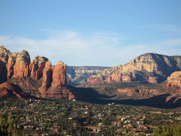
View from Sedona Sky RanchWe’d reserved two Red Rock View rooms for the night. The rooms included 2 queen beds, a deck overlooking the views, and a kitchenette with a small fridge, microwave, and sink. And a bathroom, of course. Not what I’d call luxurious, but certainly very comfortable. And the views! At about 500 feet above the town, we didn’t have to look at any ugly commercial buildings. Sedona’s famous red rocks were right there. The photo here shows the view from our deck. The rock formation in the left center is called the Coffee Pot. (Think percolator.)

Mike and I shared a bottle of wine on the deck while the sun dropped down on the horizon, making the red rocks even redder. (Mike’s mom watched television in her room.) In the overlook parking area, which was a few hundred yards away, a native American musician played the drum and flute while tourists looked on. The sun set, the flute stopped abruptly, and the tourists got into their cars to go down to their hotels far below us. The full moon rose above the buttes in the east.

The next morning, when we checked out, we made reservations for October. We chose the cabin next door, which is slightly larger that our room, has a larger deck, and a slightly better view. We’ll drive up in the Jeep with Jack the Dog (they allow pets) and spend a few days exploring the back roads of the area while the autumn leaf show is in progress.

It’ll be a nice escape.

Oh, and that “spa” Mike found online? It was on the main road in West Sedona, right next to the Safeway shopping center. How’s that for atmosphere?

A Trip to Sedona

I spend the day in Sedona, waiting for some passengers.

Yesterday, I had the pleasure of flying two very nice people from Canada from Wickenburg to Sedona for the day. We arrived at Sedona Airport, after a scenic flight around Wickenburg, Prescott, and Sedona’s red rocks, around 11:30 AM — just in time for the Pink Jeep Tour shuttle to pick us up and bring us down to the town. My passengers were taking a Jeep Tour; I planned on just hanging around downtown until they were ready to return at 3 or 4 PM. I escorted them to the Jeep Tour desk, reminded them that they could change their reservation, and watched them reserve a Jeep and driver all to themselves for departure at 1 PM. Then I left them to walk around town on my own.

The Pink Jeep Tour company’s offices are in “uptown” Sedona. That’s the heart of the tourist district in the northwest corner of town at the mouth of Oak Creek Canyon. The tourist shops that line both sides of the street there are dwarfed by the massive red rock formations behind them. But all attention in uptown Sedona is concentrated on those shops. I admit that mine was, too.

I hadn’t been to the town of Sedona for years. I’ve been flying in quite regularly with passengers, but I seldom come down off the mesa where the airport is located. There’s a restaurant up there and I usually have breakfast or lunch or whatever while my passengers explore the town on their own. They’re usually gone about 2 hours at the most, so I busy myself with a book while I’m waiting. It’s a nice, relaxing place.

But yesterday, my passengers wanted a longer stay in town. And since the Pink Jeep people offered me a lift in the shuttle, too, I went down the hill with them.

I walked the few blocks of uptown Sedona at a leisurely pace. I saw lots of T-shirt shops and lots of souvenir shops. The usual collection of real and fake Indian crafts and jewelry. Imported Mexican rugs. Jeep tour companies. Reservation centers. The wonderful map and bookstore that had been in one of the shopping areas was gone and I was sorely disappointed. I’d depended on that shop for reading material while I waited and it didn’t appear, at first, as if there were another bookstore in town. I finally found one across the street from the Pink Jeep storefront, the last shop on my walking tour.

My Sedona passengers from last week’s flight had spent only 90 minutes in town before returning to the airport. They called Sedona a “tourist trap.” And frankly, as I walked the streets, I couldn’t argue with them. But I hadn’t really expected it to be any different. I don’t know what they expected. After all, take a beautiful place, make its beauty well-known, and people will flock there. When enough people flock there, the tourist shops will start springing up like mold on old bread. After a while, those shops (like mold) completely cover the area, masking what people found so beautiful in the first place.

Now I don’t want to give you the idea that Sedona is “ruined.” It isn’t. There are still plenty of beautiful sights around town. Sadly, there are so many people there to view those sites, you’re always part of a crowd. You need to come to Sedona with your own Jeep and a trail map to get away from the herd. Bring a picnic lunch and your camera. And, for heaven’s sake, don’t come on a weekend!

I ran into my passengers on the street just before they went to lunch. They invited me to join them, but I felt as if I would be intruding, so I declined. I had lunch at a tea shop across from the Pink Jeep place and sat outside on a narrow balcony to eat and read the book I’d bought in the bookstore down below. It was windy and rather cold up there, so I didn’t last long.

Afterwards, I went for a walk back the way I’d come. That’s when I saw the Hummer tour sign. They had a 1-hour tour leaving immediately. It was the “Jeep Eater” Tour. Supposedly, this tour took passengers places were Jeeps couldn’t go. I pulled out my credit card and, minutes later, was seated in the front passenger seat of a Hummer, about 6 feet away from its driver. (Okay, so maybe it wasn’t that wide, but it sure seemed like it.) There were two passengers, a couple from Baton Rouge, in the open-air seating behind us. That was it.

The road that Jeeps can’t drive on isn’t in Sedona. It’s halfway back to Cottonwood, off of 89A. It’s a power line road — that’s a road built to maintain a power line — and frankly, there were only about 4 places on the whole ride that I would have been uncomfortable about taking my Jeep. That’s not to say that my Jeep couldn’t have done it. But I’m not sure that it could have done it with me at the wheel. During the whole ride, the driver kept pointing out other roads that the couple from Baton Rouge could explore on their own with the ATV’s they’d trailered up from home. The driver was obviously working hard to add value to the ride and maximize his tip potential. Whatever. It managed to stretch the tour out to 90 minutes, bringing us back to Sedona just when my passengers were due back. In case couldn’t read between the lines in this paragraph, I don’t recommend this tour. It wasn’t worth the $100 I spent on the tour plus tip. But at least I know what it’s like to ride in a real Hummer.

I hurried back toward the Pink Jeep place and found one of my passengers outside a gift shop. His wife was inside, shopping. They’d had a great time and had looked for me to join them before they left. I didn’t tell them about the Hummer.

I left them for a short while to pick up a gift for a friend of mine and a piece of apple pie that was really good. Then we got back on the shuttle, rode up to the airport, and flew home.

I’m glad I got to go to Sedona for the day. I feel all caught up with things down there. And I’m sure I’ll be back soon — not only by helicopter, but perhaps by Jeep to see just what my Jeep can do.

Flight Planning

A quick review of my Part 135 Flight Planning Routine

My company, Flying M Air, is an FAA Part 135 operator. What that means is that I had to go through a lot of paperwork and testing with the FAA to be allowed to take paying passengers more than 25 miles from my starting point or to land with paying passengers on board.

As a Part 135 operator, I have the FAA looking over my shoulder to make sure I do everything “by the book.” The book, in this case, is my Statement of Compliance, a 50+ page document I wrote that explains how I’ll follow the Federal Aviation Regulations (FARs) that pertain to my Part 135 operations. The FAA reviewed this document in painstaking detail and it took about three months to fine-tune it to the FAA’s satisfaction. Of course, the FAA also conducts surprise and scheduled inspections of my aircraft and my base of operations (my hangar) to make sure everything is just right. And because I’m required to be on a drug testing program, I’ve been told that I can expect a visit from the FAA’s “drug-testing police” one day in the future.

For the record, I have no problem following FAA’s requirements for my operation. They’re not asking for anything unreasonable and everything they require is in the interest of safety for me, my passengers, and my aircraft.

Anyway, one of the requirements for Part 135 operations is flight planning. And, at this point, I have it down to a science.

I start by getting the names and approximate weights of the passengers I’ll be carrying, along with our destination, expected time on the ground, and any special route requests.

Today’s a good example. My two passengers want to fly from Wickenburg to Sedona and back. They want a scenic route both ways so they can see as much of the area as possible. At Sedona, they want to take a Jeep tour at least 2 hours long. I’ll have to line that up for them so the Jeep folks meet them at Sedona Airport when we arrive. With lunch and other activities on the ground, I expect to be there 4-5 hours. I expect to depart Wickenburg at 10 AM and depart Sedona by about 4 PM. My route will take them past some of the area’s mining areas, over Prescott, near Sycamore Canyon, and past Sedona’s red rocks before landing. On departure, we’ll swing past Jerome and follow the Bradshaws down to Lake Pleasant, where I can show them some Indian ruins and the house on Sheep Mountain. A final swing around Vulture Peak and over the ranch where they’re staying will get us back to Wickenburg. Total time enroute: about an hour each way.

With this information in mind, I fire up my Web browser and visit the Duats Web site. Duats is a free flight planning service for pilots. I log in and enter my flight plan for a weather briefing that includes current conditions at airports on or near my route (Prescott and Flagstaff) as well as NOTAMs. Today I learned that we’ll have typically clear Arizona weather with the possibility of some high cirrus clouds. It’s windy right now in Flagstaff, with gusts up to 34 knots, but the wind is expected to calm a little bit as the day wears on. Still, I can expect some very light turbulence as the winds pass over the mountains we have to cross or fly around: the Weavers, the Bradshaws, and Mingus Mountain.

Duats also has a flight planning feature and I use this next. It takes the information I’ve already entered to get the weather and uses it to calculate the route and enroute time for the flight. Since I can’t put as much detail into Duats as I need to, its flight plan is much simpler than my scenic route. It says it’ll take 45 minutes to get there and 40 minutes to return. I file both of those flight plans, each with their own times (10 am and 4 pm) with the FAA. They’ll sit in the FAA’s computers until I either activate them (one at a time, of course) or they expire.

Next, I whip out my Manifest form. This is an Excel spreadsheet I designed that automatically calculates weight and balance for my helicopter. I enter all the flight plan information, as well as my starting fuel load and the names and weights of my passengers in the seats I expect to put them. For weights, I add 20 lbs. I used to add 10 lbs, but the folks who book these flights don’t seem to have a clue about weights. It’s always better to overestimate than underestimate. And since it’s nearly impossible to load an R44 out of CG, it doesn’t matter if the two passengers sit somewhere other than the seats I expect to put them in. When my passengers are light — as these two are — I usually put them both on the same side of the helicopter so they have the same basic view. I then fly so that the most interesting views are on their side. But if they both want to sit in back, that’ll work, too. Or any combination they want.

The Manifest form is also designed to be used when I don’t have access to the Internet. It creates the same flight plan that I file with the FAA. So if I have to get the weather from a telephone briefer, I can file my flight plan over the phone at the same time rather than via the Internet.

If I have access to a printer, which I usually do during flight planning, I print out my manifest form for each leg of the trip, my flight plans for each leg of the trip, and my weight and balance for each leg of the trip. If I plan to start each leg of the trip with the same amount of fuel and take the same amount of time, I only print one weight and balance sheet. No sense wasting paper. But today I printed two sheets — I plan to fill up in Sedona since my passenger load is light and fuel is currently cheaper there than in Wickenburg.

I usually give a copy of my manifest — that’s the form with the passenger names and flight plan — to Mike. He’s my backup flight following. I call Mike when I depart and arrive each leg of the trip. If I don’t call in on time and he can’t get me on my cell phone, he takes the next steps with Flight Service.

Of course, I also open my filed flight plans with the local Flight Service Station (FSS). Although I prefer to do this on the ground before I start up, the FSS prefers that pilots do this on departure. My problem is that as a helicopter, I don’t always get enough altitude to access one of the radio frequencies the FSS uses. So I sometimes can’t activate a flight plan until I’m 10 minute into my flight. I close the flight plan by phone when I land, then call Mike to let him know I’ve arrived safely.

All the paperwork that’s generated for the flight is left on my desk in my hangar. After the flight is done, I file it. The FAA likes to look at these papers when they do their base inspection, even though I’m not required to save them.

And that’s about it. As you can see, the whole routine is designed to make sure I properly plan the flight and have at least one form of flight following to make sure a search is conducted promptly if I do not arrive at my destination. It sounds like a lot of work, but I can normally do it in less than 20 minutes with my computer and an Internet connection. To do it manually would take about twice the amount of time.

So I’m flying to Sedona today. I’d better bring a book; I have a feeling I’ll be spending a lot of time at the airport there.