Hunting for hidden treasures.
Back in 2005, I discovered geocaching, an outdoor activity where people use a GPS to find hidden containers of trinkets. I wrote about my thoughts on the topic — and some big plans that never came to fruition — in some detail here. Because part of the game is to pull something out of a cache and replace it with something else, I started gathering items to share. Among these were some “travel bugs,” which are basically serial numbered tags you can affix to an item so it can be tracked. The tracking is mostly done on the Geocaching.com Web site. That’s also were you can find a list of geocaches just about anywhere in the U.S.
And that’s the interesting thing: these things are everywhere. Did you drive more than 10 miles to work today? I bet you passed at least a dozen of them within 3 miles of your car. There’s one a block from my house in Wickenburg and one 4/10 of a mile from my RV here in Quincy. As this map shows, they’re all over the place:
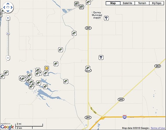
My RV is just about dead-center in this map. The little box and question mark icons indicate geocaches in the area. The smiley face icon is a geocache I found that I logged.
For some reason, I find the proliferation of these little boxes of hidden “treasure” fascinating. It emphasizes how big the world really is. It also reminds me a bit of a walk my husband, Mike, and I had along the rim of the Grand Canyon once. We got off the beaten path and walked right along the rim, far from where the tourists wander. We happened to stop for a rest on a rock outcropping. And there, tucked under an overhang with a beautiful view of the canyon, was an urn of cremated remains. How long had it been hidden there? We didn’t know. It was like an uncharted geocache. Seems like a good final resting place to me.
Geocaches are hidden. They’re tucked away in painted coffee cans, sealed lengths of black PVC pipe, and plastic Tylenol bottles. In the old days, ammo cans were popular, but I think the value of these has prevented their widespread use — too likely to be stolen if found. (I bought 3 nice-sized ammo cans from a seller in Beatty, NV some years back to create my own geocaches; I still have them.) Caches are hidden in bushes, under rocks, and among the remains of pioneer trash heaps. You’re not likely to stumble upon any of them by accident. You have to look for them. And even with GPS coordinates, they’re not always easy to find.
For some reason, I brought my bag of geocache goodies along with me on my trip to Washington this year. I guess I thought I’d try it again. I didn’t think much of it until the other day when a Twitter friend, @PlagiarismToday, started tweeting about his weekend geocaching activities. It got me thinking about it. I pulled out my bag and took a look inside it. I had a GPS with me, and an Internet connection to get information about local caches, so I had everything I needed to try again.
So I went out yesterday to search for three caches. I found three, but not the original three I’d set out to find.
- Ryann’s Hide was the first cache I’d hunted for in over 5 years. Although I’m using a newer GPS (a Garmin GPSMap 60c) than I did in 2005, I soon realized that precision was something that needed patience. As I walked, the GPS would guide me, but I quickly overshot the location. Seems that the GPS could not keep up with my movement. I needed to slow down and let the signals catch up. Zooming in on the map gave me ever-increasing detail. Standing still, gave me ever-increasing precision. Once I caught on, I was able to zero in on the location. The cache was alongside a two-track road that led down a hill to a fishing spot. The road was closed to unauthorized vehicles. It started on the edge of an orchard and curved down into a very pleasant wooded area. (I think I need to explore further down that trail.) The container was a painted coffee can with a plastic lid. I pulled out a plastic car and replaced it with a tiny stuffed teddy bear. I entered my Geocaching.com user name in the log book, closed everything back up, and replaced it exactly where I’d found it. Success!
- Quincy Valley Rest Area II was a bit easier to find — once I got on the correct side of the rest area fence. It was a nicely made cache container consisting of a short length of black PVC pipe with a screw-top on one end. Inside was a baggie with the logbook, some plastic dinosaurs, and a very nice shell. I took the shell and replaced it with an emery board with advertising for a nudist colony on it. (I really don’t remember where I got such a thing, but it is pretty funny — and clean.) I logged my visit and closed it all back up. Success!
- West Bar Overlook is the one I really wanted to find. It’s located on Babcock Bench, high above one of the orchards I dried several times this summer. The entry on Geocaching.com provided lots of photos and information about the geologic significance of the spot. I’d brought along my camera, planning to get some shots from its perfect vantage point. Unfortunately, the two-track access road that appeared to link the cache area with pavement was inaccessible. Not only was there a locked gate across the road, but there were lots of tall weeds making the start of the trail a bit questionable for someone wearing shorts during snake and tick season. I’ll either try again next spring, before the weeds grow so tall or possibly try to visit via helicopter. I already scouted the power lines in the area. So this was a failure.
- Rust Everywhere was my consolation prize. I’d already imported its GPS coordinates into my GPS, so I knew approximately where it was. But because I hadn’t planned to look for it, I didn’t have the details — like a basic description of what it looked like. Having a location but no description makes things a bit tougher. Patience and perseverance paid off, though. The cache was a label-less Tylenol bottle hidden well among rocks. I pulled out a kid’s hair clip and replaced it with a computer chip, logged my visit, and put it back. Success!
In all, it was a nice way to spend the afternoon. I was at it for about two hours and it got me out and about. To onlookers, I must have looked pretty silly, walking around while studying a GPS. But I got to find a neat place — that wooded trail — and get some exercise and fresh air. I hope to do more tomorrow.
I also think that it would be a great family or small group activity. A way to combine socialization with exercise. Working together to complete a challenging task.
I do have a geocaching project lined up. I’m going to release one of my travel bugs into the wild with the mission of traveling down to New Orleans, LA. That’s where @PlagiarismToday lives and does his geocaching. He, in turn, is going to send one my way. We’ll see which one completes its mission first.
I’ll likely blog about the progress here.
 I was airborne by 10 AM.
 I was now squarely in the middle of my middle-of-nowhere route from Page to Bryce Canyon. There were absolutely no signs of civilization below me or anywhere within sight. Instead, an ever-changing terrain revealed itself below me. Hills and mesas were cut deeply by canyons of exposed red rock. Sedimentary rock thrust up from the ground at odd angles, forming layered ridge lines that stretched for miles. Ancient sand dunes turned to rock stood revealed by the erosive forces of wind and rain over millions of years.
  The view seemed to change every five minutes, revealing wonder after wonder. I wanted to detour and explore. I wished more than ever that I’d installed my helicopter’s nose camera before departing Wickenburg the day before.
 I finally began seeing signs of civilization: paved roads, ranches, towns. There were plenty of red rock cliffs and hoodoos with roads — paved and unpaved — winding around them. Funny how people go to National Parks to see the sights when the same sights — or better ones — can be found right down the road.
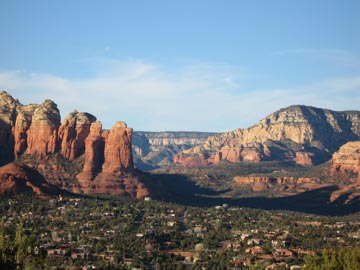 We’d reserved two Red Rock View rooms for the night. The rooms included 2 queen beds, a deck overlooking the views, and a kitchenette with a small fridge, microwave, and sink. And a bathroom, of course. Not what I’d call luxurious, but certainly very comfortable. And the views! At about 500 feet above the town, we didn’t have to look at any ugly commercial buildings. Sedona’s famous red rocks were right there. The photo here shows the view from our deck. The rock formation in the left center is called the Coffee Pot. (Think percolator.)
 Howard Mesa was beautiful. Or maybe I should say that it was more beautiful than usual. The grass was knee-high and green and the seed tops swayed with the wind. The San Francisco Peaks were still snow-covered, off in the distance. Best of all, we seemed to have the whole place to ourselves — as usual.
 The trail, which was wide enough for hikers, bikers (the pedal kind, that is), or horseback riders, was smooth and covered with crushed red cinders. In places, it was heavily eroded, but not enough to make walking a problem. That was a good thing, because I hadn’t brought hiking shoes. I was wearing my red Keds and that’s probably the only kind of surface I could have walked 3 miles on. The trail climbed gently most of the way. It wound through the trees, then dropped into a smooth-bottomed wash and climbed toward the mountain in that. Soon, we were in a canyon with slopes of dark grey volcanic gravel on either side of us. It was fine stuff, like the red cinders we walked on. There were a few interesting formations right at the mountain’s entrance. Beyond them, we could see the red hoodoos inside the mountain.
 It appears to me that Red Mountain had once been a plain old mountain. Volcanic activity on one side had caused black lava to spew out of the ground. This undermined the mountain, causing a slide that took out about 1/3 of the mountain side. The result was the amphitheater the booklet told us about. Of course, this is all conjecture based on what it looked like. There was no interpretive sign in the parking area or elsewhere and no ranger to explain what we were seeing. I could have it completely wrong.
 There are two ways into the mountain, both of which were described in the book. At the head of the wash we’d been following, someone had built a neat rock dam. A ladder climbed the six or eight feet up to the top of the dam where silt had backed up, raising the ground to the top of the dam. That’s how we went. Jack took the ladder like a champ. The other way was to climb up over a gray cinders covered slope. That’s probably the only way you could get in with a horse. (I know my horse doesn’t climb ladders.) Our way was easier. Inside the mountain’s amphitheater was exactly as the booklet had described. Lots of rock formations made of red sandstone carved by wind and water, with a bunch of dark gray formations just to make things interesting. We walked up to the head of the canyon, passing a family having lunch with their dogs. One dog, a Corgi, came yapping out after us, followed by a dog that looked like a mix of every dog breed in the world. Jack had some sniffing with them, then followed us.
 I took this photo of Jack as we neared the parking area. It’s the new desktop picture on my laptop. That’s the San Francisco Peaks in the background; you can see Jack running on the trail, tongue hanging out, on the left.