Why I Blocked You on Twitter

The answer to a question I received by email.

The other day, I got the following email message through the message form on this blog:

Just curious. Why did you block me on Twitter? @[redacted]

Was interested in following your flight home with the new bird.

I honestly don’t remember blocking this specific person. I probably block about a dozen people a week.

Twitter LogoThe reason I usually block people is because of their unreasonably voiced political views. You know the kind of folks I mean: the ones who watch Fox News and echo the bullshit they’ve been fed there. The ones with #MAGA in their Twitter profiles. The ones who share obnoxious memes that bash Obama or Clinton or liberals in general.

Yes, I’ll admit it: I block Trump supporters who attempt to interact with me on Twitter. I honestly have no time or patience for their bullshit. I am a New Yorker at heart and, like most New Yorkers with a brain, I know that Donald Trump is a conman. During the 2016 presidential election, he conned the same kind of people he conned into signing up for Trump University: the desperate and the gullible. I am neither and no one will ever get me to support him.

And frankly, I’m offended by the kinds of things his supporters do and say to attack the people who don’t support him.

Twitter is a haven for these people. They make a game out of preying on people who don’t agree with them, using personal attacks and ridicule, often getting other Trump supporters to join them. They try to make a living hell for the people they find on Twitter who dare to question their glorious leader. It’s fortunate that Twitter makes it easy to prevent these people from targeting us — that’s what the Block feature is for and I’m not afraid to use it.

So there’s a good chance that’s why I blocked the person who emailed me last week. I was simply heading off what I thought might be a Trump supporter following me to see Tweets he could attack. It’s happened before and it’ll happen again.

If I erred and he really was interested in following my trip, he would have been disappointed anyway. I didn’t tweet much along the way. And a blog post about it will be posted here shortly; he can always read that to catch up.

And if that’s truly all he wanted from me, I do apologize. But if he’d been on the receiving end of as many Trump supporter attacks as I have on Twitter, I think he’d understand.

Planning the Long Flight Home

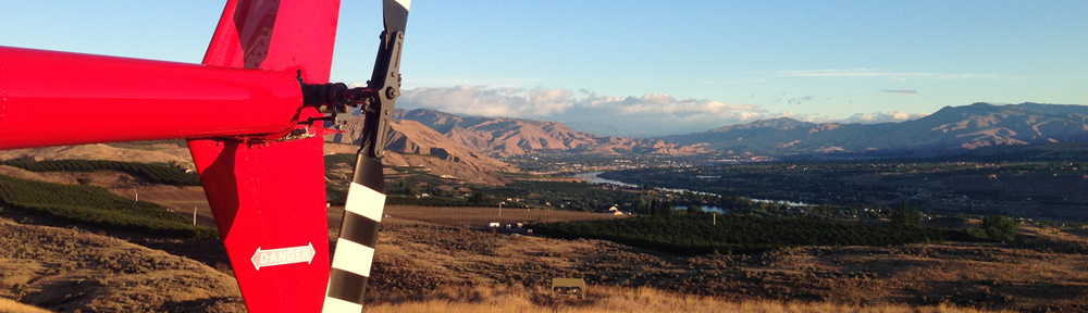
I begin flight planning for the trip from Phoenix, AZ to Malaga, WA with my new helicopter.

I haven’t been blogging much about flying lately, but that’s because I haven’t been doing any lately. It took me about a month to find a good replacement for my old helicopter and, truth be told, I haven’t even gone to see it in person so I don’t have any good stories or photos to share. I’m thinking of discussing the purchase in a separate blog post and if life doesn’t stop hurling distractions at me, I might just get that done. But it’ll be a complete piece — from the start of the search to the pickup of the replacement helicopter — and since that process isn’t complete yet, I can’t very well write about it.

So instead I’ll give you an idea of what’s going through my mind this weekend and week as I plan to fly the replacement helicopter home from the Phoenix area.

Planning a Flight in the American West

The one thing that city folks — and people from areas areas that are normally or densely populated — don’t get is that out west there can be very long distances between points. And since there aren’t as many people here outside the big cities, there can be a whole lot of nothing on a long cross-country flight. Or even on a relatively short one. Heck, when I was first building time in my R22, I once flew solo in a straight line 85 miles east to west just north of the Grand Canyon’s airspace and didn’t cross over a single paved road for the entire distance. Can you do that in New York?

I used to fly between Arizona and Central Washington twice a year. From 2008 to 2013, I lived in Wickenburg, Arizona and spent 7 to 16 weeks every summer in the Wenatchee area of Washington for cherry drying. In May, I’d pack up the helicopter and fly north and in July or August, I’d pack it up again and fly south. I often had a pilot interested in building time in an R44 at the stick to help cover flying costs; once (I think) it was my future wasband, who got the flight time for free on a flight that included a good part of the Oregon coast.

There are basically four good routes — five if you count the California/Oregon coastal route — to get from the Phoenix area of Arizona to Central Washington State. Those routes are determined primarily by terrain, fuel availability, and airspace restrictions.

The Shortest Route

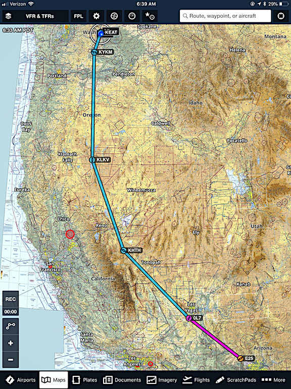
By far, the shortest route is through the middle of Nevada. Going north from Wickenburg (E25), it’s Mesquite, NV (67L), Elko, NV (EKO), Burns, OR (BNO), to Wenatchee, WA (EAT). Note that those legs are pretty long — 2-1/2 or more hours each. But it’s only 891 miles total and I’ve done the whole flight in a single day twice with another pilot on board.

The Shortest Route
Here’s Foreflight with the shortest route plotted in. I added a waypoint to route me around the Grand Canyon’s airspace, which I can’t fly through. There’s a whole lot of nothing on this route.

Pros:

  • Short route; it can be done in less than 10 hours without headwinds.
  • The shortest route is also the cheapest route.
  • Only three fuel stops also speeds up the trip; stopping for fuel takes at least 30 minutes.
  • Between Elko and Burns, there are many herds of wild horses.

Cons:

  • Not many options for fuel if headwinds slow you down. Rerouting along the way could make the trip a lot longer.
  • Flight crosses miles of empty desert with absolutely no sign of civilization. For example, there’s a stretch between Elko and Burns where there are no roads, buildings, or even fence lines for more than 90 minutes of flight time. So if you need to land because of a problem, you’re pretty much screwed.

The Salt Lake City Route

Salt Lake
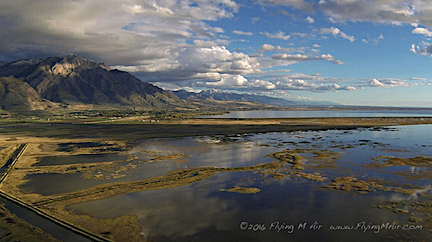
My GoPro nosecam captured this amazing image of Salt Lake on my last flight southbound through the area in October 2016.

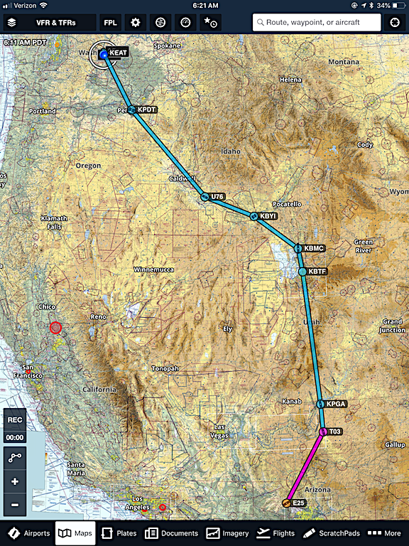
When I flew the late, great Zero-Mike-Lima south to get its overhaul back in 2016, I took what I call the Salt Lake City route. This route follows roads pretty much all the way. Zero-Mike-Lima’s engine was nearly 12 years old and an oil change had uncovered more than the normal amount of metal fragments in the filter. If the engine was going to give me trouble, I wanted to be able to land somewhere close to where I could get help and that meant near a road. An example of this route goes from Wickenburg (E25) to Page, AZ (PGA), Salt Lake City (Skypark), UT (BTF), Burley, ID (BUR), Pendleton, OR (PDT), and Wenatchee (EAT). This comes out to a minimum of 985 miles.

The Salt Lake City Route
This is what I call the Salt Lake City Route, IFR edition. I’ve added waypoints beyond the fuel stops listed here, to guide me around the Grand Canyon’s airspace and keep me over roads for most of the way.

Pros:

  • I can be an IFR (I Follow Roads) pilot. There are very few stretches along this route that can be considered remote.
  • There are corner-cutting opportunities to save time and fuel. For example, if I don’t mind flying over Salt Lake, I can go direct from Salt Lake City to Burley. (I really don’t like flying over water so I’ve only done that once.)
  • There are many potential fuel stops along the way. And many options for short detours to get to them.
  • The first 2 hours of this flight takes me over my old stomping grounds in northeastern Arizona, including the Navajo Reservation and Lake Powell.
  • My friend Megg lives in Salt Lake City and has, more than once, provided overnight accommodations.

Cons:

  • It’s not the shortest route. I don’t think it can be done safely by one pilot in a day.
  • It crosses over a lot of high elevation terrain. In April, that means there’s a real possibility of snow or icing conditions that I can’t fly in. Getting grounded because of weather wastes time and gets expensive.

The Western Nevada Route

Another way to go that successfully avoids the restricted airspace in Nevada is up the east side of the Sierra Nevada Mountains and up into Oregon. In looking at this route, I realized that I’d never done the whole thing. Once I traced the Tonopah (southeast of Hawthorne) to Wickenburg part of this route with my wasband on board when we had to abandon the coastal route, stopped for the night at a friend’s house in Georgetown, CA, and came over Echo Pass near Lake Tahoe. We might have cut through Death Valley along the way. The route I’m looking at now is at least 942 miles: Wickenburg (E25), Jean, NV (0L7), Hawthorne, NV (HTH), Lakeview, OR (LKV), Yakima, WA (YKM), and Wenatchee (EAT).

Western Nevada Route
The western Nevada route is one I’ve never done before, but it looks like it might work out.

Pros:

  • Relatively short route.
  • Not completely familiar so I’d get to see new sights.
  • A stop at Hawthorne would mean getting to see Betty, the unofficial airport greeter there.

Cons:

  • Not completely familiar so I’d have to be even more prepared for the unexpected than usual.
  • Fuel stops are limited so monitoring fuel consumption and planning well in advance is vital, especially with headwinds.
  • There’s some remote terrain. Help might not be close in the event of a problem.
  • There’s some high elevation terrain. Winter weather could be an issue in April.
  • With restricted airspace and high mountains on either side of the Nevada portion of the route, there aren’t many opportunities to divert for fuel or overnight accommodations.
  • The Central California Route

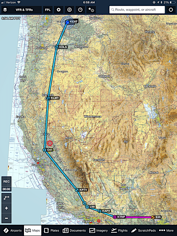
    The longest two routes take me through California. The shorter version goes up the Central Valley of California. I basically head west through the Arizona and California deserts, then pop over the foothills of the Sierra Nevada Mountains at Tehachapi and fly up the Central Valley. Then I continue North through Oregon on the East side of the Cascade Mountains. A flight plan might be Wickenburg (E25), Apple Valley, CA (APV), Porterville, CA (PTV), Woodland, CA (O41), Redding, CA (RDD), The Dalles, WA (DLS), and Wenatchee (EAT). That’s a minimum of 1100 miles.

    Central California Route
    The Central California route is long but very familiar. The stops shown here are just an example; there are plenty of options for fuel and overnight stay in the Central Valley.

    Pros:

    • I know this route really well. I can’t tell you (without looking in my log book) how many times I’ve flown either the entire thing or parts of it.
    • There are lots of places in California’s Central Valley for fuel and overnight stops.
    • More than half the route is through heavily populated areas. Plenty of places to get help if needed.
    • There is very little high terrain so winter weather is not likely to be an issue.
    • Weather is nearly always perfect — although it could be windy — in the desert areas.
    • I can stop along the way to pick up the cockpit cover for my old helicopter, which is somewhere in the Sacramento area of California.

    Cons:

    • The route is long. Enough said.
    • There’s a chance that you won’t be able to cross into the Central Valley at Tehachapi because of low clouds on the Central Valley side. The wind seems to funnel the weather south and when the clouds hit the mountains there, they just stop and accumulate. I’ve had this happen to me twice. The options are to wait it out or detour farther west to Grapevine.
    • Just under half the route is through sparsely populated areas.
    • There are limited fuel stops in the desert areas and in Oregon.
    • Did I mention that the route was long?

    The Coastal Route

    Bonneville Dam
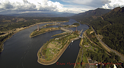
    When I fly back from the coast, I usually fly along the Columbia River. Here’s a nosecam shot of the Bonneville Dam. I can’t get my hands on any of my coast photos right now.

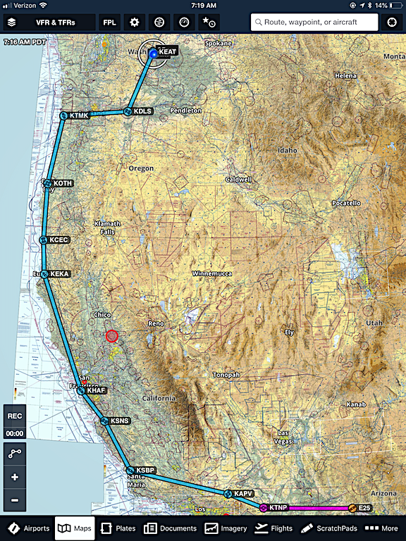
    If you’ve never flown in a small aircraft, low and slow up the coast of California and Oregon, you have no idea what you’re missing. When the weather is good, the flight is absolutely amazing. I’m talking about tiny seaside communities, waterfalls plunging off cliffs into the Pacific Ocean, and odd rock formations just off the coast with waves crashing picturesquely against them. If time and money is no object, this is the way to go. A typical route might be Wickenburg (E25), Apple Valley, CA (APV), San Luis Obispo (SBP), Half Moon Bay, CA (HAF), Eureka, CA (EKA), North Bend, OR (OTH), Tillamook, OR (TMK), The Dalles, WA (DLS), and Wenatchee (EAT). Those aren’t all fuel stops; they’re just points along the way where fuel is available. This flight is over 1300 miles long if you follow the coast as closely as possible. It’s a lot longer if you join the coast at a point south of San Luis Obispo — for example, Santa Barbara (SBA) or Long Beach (LGB).

    The Coastal Route
    Got money to spend and time to kill and you don’t mind gambling with Mother Nature? Then do the coastal route. The extra waypoints I plotted in here are just to keep you on the coast as much as possible. You’d have to calculate and pick your fuel stops.

    Pros:

    • The scenery! There’s none better.
    • Lots of fuel stops — if you plan properly.
    • Did I mention the amazing scenery?

    Cons:

    • Weather. The chances of being able to stay on the coast for the entire distance from San Luis Obispo to Tillamook are about as close to zero as you can get without hitting zero. The marine layer is real and it will definitely force you inland for at least part of this route. That means you need to have an infinite number of Plan Bs. And there’s nothing worse than flying out of your way to get to the coast and then having to backtrack because it’s socked in with fog.
    • Possibly flying over water. I hate flying over water.
    • Some of the coastal areas are quite remote. So even if you’re flying over land, if you have a problem and need to land you might not be anywhere near help.
    • You can’t stick to the coast in certain wildlife refuge areas unless you want to climb to 2000 feet. I get nosebleeds up there.
    • The airspace gets a little crazy around San Francisco, especially if you have to come inland.
    • And seriously: 1300 miles for a trip you can do in less than 1000 miles on at least two other routes? A bit extravagant, no?

    Picking a Route

    Those are pretty much the options I’m looking at. I was leaning toward the Central California route until I started looking at the Western Nevada route in more detail. It definitely has possibilities and I shouldn’t write it off just because I haven’t done it before. If it saves me 2 hours of flight time, that’s hundreds of dollars in ferry flight costs. While I don’t think I can do it in a day, it’s definitely feasible.

    In the end, there are just two things that will help me make the decision: the weather forecast and whether I can stop in California to fetch that cockpit cover. And although my flight is scheduled to begin on Friday, April 13 — yeah, I know — it’s still to early to get a reliable forecast. I’ll likely decide by Wednesday or Thursday — and be prepared to change my mind.

    That’s how flight planning goes.

    Another (Brief) Facebook Rant

    This might be enough to get me to completely pull the plug.

    I’ll admit it: the only reason I haven’t completely pulled the plug on my Facebook account is because I use it to promote two businesses: Flying M Air and ML Jewelry Designs.

    Flying M Air has been on my Facebook account for years. For a while, I tried hard to use Facebook to share information about what the company is doing through events, offers, galleries, and plain old posts. I was checking in daily to stay on top of messages. Flying M Air’s website has an annoying pop-up window that invites visitors to like us on Facebook. (I’m still trying to figure out how to turn that off.) The only thing I didn’t do was pay money to promote a Facebook post.

    And here’s the rub. Flying M Air’s Facebook page has over 1000 likes. That means that over 1000 Facebook users have indicated that they want to see new content. I don’t post much anymore — heck, there are only five or six new posts since July — so it isn’t as if I’m bombarding page followers with content. It doesn’t matter, though. Facebook isn’t showing this content to the people who want to see it. Indeed, one of my posts from last summer “reached” only seven people.

    Yeah. Seven out of over 1000.

    Facebook Post
    This post came out two days ago, yet was shown to only ONE person. For all I know, it could be me.

    Against my better judgement, I set ML Jewelry Designs up on Facebook, too. I figured: why not? But rather than put a lot of energy into keeping its page up-to-date with new content, I set up new posts on its WordPress-based website to automatically post to the ML Jewelry Designs page on Facebook. This means the page gets new content just about every day. (I schedule posts so no more than one new item appears each day.) Now the page is less than a month old and has only 20 followers. But I’m getting the same ridiculous low reach numbers I get with Flying M Air.

    So here’s the situation. Facebook users have indicated that they want to see the content posted on certain pages. But the Facebook algorithm has decides what they should and shouldn’t seen. My two business pages don’t pay for “promotion” so they’re pretty far down on the list of what gets shown. As a result, my content doesn’t appear for anywhere near the number of people who have indicated they want to see it.

    So why bother posting it?

    And what about the people who like a page because they want to see all of its new content? How many of them think there just isn’t anything new because it doesn’t appear in their newsfeed?

    Can you see why I’m just so done with Facebook?

    Jewelry Making: A Hobby Gone Wild

    An update on my wire-wrapped jewelry endeavors.

    By now, the folks who know me well know that my jewelry making hobby has blown up into something resembling an addiction. Indeed, it’s difficult for me to pass up a shop or website that offers gemstone cabochons (cabs, to those of us who work with these things) for sale without taking a look — and likely buying ones within my budget. I’ve now got a collection of about 4 dozen cabs in various shapes and sizes made of a stunning selection of stones. They’re almost all polished to a reflective shine. Just gorgeous.

    The weird thing about this is that I’ve been going to Quartzsite, AZ where I bought about half the cabs I have now, for more than 20 years and saw cabs for sale every single year. It wasn’t until I realized what I could do with them that I began buying them. And when I started getting kind of good at turning them into jewelry, the draw became irresistible. I’ve since found a good supplier on Easy who sells decent quality stones at a reasonable price. I’ve bought two dozen from them in the past two weeks.

    More about Cabochons

    A cabochon, in case you’re wondering, is:

    a gemstone which has been shaped and polished as opposed to faceted. The resulting form is usually a convex (rounded) obverse with a flat reverse.

    Nevada Dendritic Sage Agate Wrapped in Silver
    Nevada Dendritic Sage Agate wrapped in sterling silver. I don’t think you can make a bad piece of jewelry out of such a nice stone — if you let the stone show.

    Lapidaries create cabs by cutting stones into slabs, then cutting those slabs into shapes and polishing them with wheels of varying grits. I’ve seen guys do this and it looks like a ton of work. A good lapidary can produce beautiful cabs by finding the best features in a slab and featuring them in a finished cab. Those are the cabs I look for when I’m shopping.

    Cabs range in size from very small — maybe 10 mm long — to quite large — over 50 mm on a side. I prefer them 30 to 45 mm long and 15 to 30 mm wide. Smaller than that and they’re tough to work with; larger and they make heavier pieces than I like.

    Although I do like working with odd-shaped pieces, it’s a bit more challenging to get them properly wrapped. My skills aren’t quite reliable enough yet to tackle them successfully. So I stick with ovals, teardrops, and elongated pieces. I’m just starting to get the hang of dealing with square corners.

    Turning Cabochons into Jewelry

    There are basically three ways to turn a cab into a piece of jewelry:

    • Drill a hole in it and use that to secure a finding or beading string. Drilling a hole in a stone basically turns it into a bead. I don’t do this. I don’t like the idea of drilling into a beautiful stone or using a hole to secure it in jewelry. That’s my opinion. I’m sure a lot of beaders would disagree. Sorry. (I should add here that when working with very small stones, I think beading is the way to go. I may use gemstone beads as accents in future pieces; I’m still thinking about it.)
    • Use wire wrapping to secure the stone into the jewelry piece. This is what I do. There are several styles of wire-wrapping; the style I use is rather intricate, although I have experimented with simpler styles. I usually use 20 to 22 gauge square or round wire wrapped with 22 gauge half-round wire to create a custom frame for a stone, build a bail, and secure the stone into the frame. Then I use the excess frame wire to create accents with loops and swirls.
    • Cut and solder metal to create jewelry mounts for stones. This is another nice way to turn a cab into jewelry — especially if the cab’s reverse side is marred or unfinished. This is both harder and easier than wire-wrapping. It’s harder because you need good metal cutting and soldering skills. But, in a way, it’s also easier because you can work with virtually any size or shape cabochon and get good results.

    I’ve begun work on a blog post providing more detail on how I make my pieces. The only thing I need to finish it are step-by-step photos. It won’t be enough to teach you how to do it, but at least you’ll see what I do. There are some good videos on YouTube to get you started if you want to try and I’ll link to the ones I think are best in that blog post.

    The Metals

    K2 Granite wrapped with Silver
    This is K2 Granite — yes, from the mountain K2 — wrapped in sterling silver. The colored specs are natural. I’d score this a 5 out of 5; it’s currently my favorite piece.

    Lately, I’ve been working almost exclusively with sterling silver, although I have worked with copper and silver plate in the past. (When getting started, it’s a good idea to work with cheaper metals.) My friend Dorothy sat down with me when we were both in Quartzsite in January and showed me how she makes her jewelry. That was the first time I worked with sterling silver. She stressed the importance of tight, even wraps and put me on the right track in a search for perfection. Every time I finish a piece, I give it an objective score of 1 to 5, with 5 being the best. I’m always shooting for 5s but am happy with 4s. I learn a lot from 3s and usually disassemble anything that scores lower than that.

    Dorothy also taught me to save every single bit of silver that gets cut away from the piece. When my little plastic container is full, I can send it back to the silver supplier for credit on the purchase of more silver. At $16.60 per ounce (today’s price), those trimmings can really add up.

    My Progress

    I’ve come a long way since I started creating wire-wrapped gemstone cabochon pendants back in January. In fact, I look at some of the pieces I created back then, remembering how proud I was of them, and cringe.

    My First Pieces
    My first pieces, prepped for sale. I’ll be selling these for just $10 each — a fraction of what I charge for my later pieces.

    Why cringe? Well, most of them are terribly crude and generally immature. All those swirls — what was I thinking? This is the kind of jewelry a teenager would wear. That’s okay, but I’m not interested in making jewelry for teenagers.

    Now compare those pieces to my most recent work here (and in closeups above):

    Recent Wire-Wrapped Jewelry Pieces
    Here are some of the pieces I created in the past week, all tagged and ready for packaging for sale. They range in price from about $40 to $50 each and are sold on a leather necklace with a hand-formed clasp.


    If you like videos, try this one. It’s a show and tell for four recent pieces. (I really need to get a better setup for future videos.)

    I think these designs are more finished looking and mature. (Maybe it’s just a matter of taste, though.) Not only am I using better cabochons, but I’m also wrapping them with sterling silver, although I haven’t completely given up on copper yet.

    And yes, I am selling them. There’s a website where new pieces appear as they are finished: www.MLJewelryDesigns.com. There are links there to an online store. Selling them makes me happy and sad. Happy because other folks value what I do but sad because I hate to see them go.

    I’ll also be at a kiosk/table at Pybus Public Market on three upcoming Saturdays, including this Saturday, March 31. I figure I’ll sit there for the day and make new pieces — maybe even some custom ones from unwrapped cabochons I’ll have on display and for sale. If you’re around, I hope you’ll stop by.

    But if you’re not in the area, please do visit my online store and treat yourself or a loved one to a unique gift. I sure could use a cash inflow to feed my hobby with stones and silver wire!

    Open Letter to My Facebook Friends

    A version of what I posted on Facebook yesterday.

    Facebook Logo
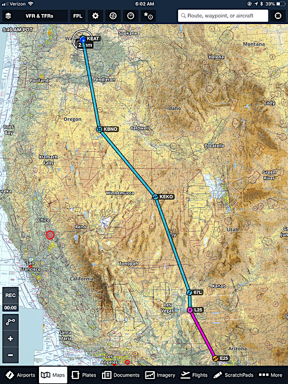
Okay, folks. Most of you should know that I’ve pretty much removed myself from Facebook, popping in now and then just to share a link to a blog post and comment on friends’ posts. I went from being on Facebook for more than an hour a day to being here less than an hour a week and I love having that time back in my life.

    I’m still on Twitter a lot and although I know a lot of you “don’t get” Twitter, I do and I really enjoy it. One reason: every tweet from every person I follow always appears in my newsfeed, in reverse chronological order. In other words, Twitter doesn’t use algorithms to decide what I should see and bury the rest.

    I’ve been wanting to delete my Facebook account for quite some time now and recent news is making me think again about how foolish it is to participate in a social network that manipulates what content appears for me and other users. I’m very upset that the manipulation has changed how some of my friends and family members think about what’s going on in the world and the amount of hate the content they share seems to generate.

    In short: I feel that Facebook and its paying advertisers are brainwashing users, making the people in the country I love ever more divided. I don’t want to be part of that in any way.

    So there’s a pretty good chance that the blog post link I share in a moment will be the last one I share here. And an equally good chance that I’ll be deleting my Facebook content and account very soon.

    That said, I’d like to keep in touch with all of you. Although I assume that Facebook’s algorithms will show this to a tiny percentage of the 300+ friends and hundreds of followers I still have here, I’m asking those of you who see this to take a moment and let me know where else I can find you online: your Twitter name, blog URL, email address, and/or cell phone number. You can put it in a private message if you like. I want to keep in touch with the folks I like, but I don’t want to do it on Facebook.

    I hope you understand.