The Server Project Begins

I [finally] get Mac OS X 1.4 Server and start to plan for installation and deployment.

If you’ve been following this bLog, you know that I recently purchased Mac OS X 10.4 Server from someone on eBay. I got the software at a smoking price — less than the Apple employee discount, in fact — and considered myself very fortunate. The only thing I can’t figure out is why it took the seller more than 10 days to send the software to me in a flat rate Priority Mail box.

The software arrived in good condition. The box looked a little worn, as if it had been handled by too many people or shuffled around from one shelf to another. But the seals were intact and the box appears to contain all the discs, documentation, and proof of purchase info — including the all-important serial number — that a legal copy of the software should. So I’m pretty confident that I did not buy used or pirated software.

Now that I have the software, I have no excuse to put off my big server project.

The goal, as I think I’ve mentioned elsewhere, is to install Mac OS X 10.4 server on my current Web server machine and use the following features:
– Web server (Apache) with PHP and MySQL for dynamic content
– E-mail server
– Mailing List server
– FTP server
– Streaming Video (QuickTime)
– Blog

I’ll also set up secure space on the server to back up my own personal documents, as well as Mike’s.

In addition to all that, the server will continue to run the same other services the server runs now:
– FileMaker Pro databases
– Webcam
– Steaming Audio (for KBSZ-AM)

All this on a Power Macintosh G4 running at 866 MHz. Seems pretty ambitious, but we’ll see how I can do. If all else fails, I’ll take my old G3/300 (beige, mind you) out of retirement and use that for the Webcam and FileMaker Pro databases.

I’ve made a list of steps that need to be done to get the project going. Here’s what I hope to accomplish today:

1) Adjust the upload address for all Webcams. Although the KBSZ-AM Webcam currently uploads to some GoDaddy hosting space I have, I think the wickenburg-az.com and Editor SpyCam Webcams both upload to my current server. I need them to upload someplace that won’t be affected by the change — probably that GoDaddy space — so I don’t lose Webcam service. I also need to adjust all Web page references to that new space.

2) Adjust the file locations for the ini files I use to display sunrise/sunset and upcoming event info on various Web sites. This information is generated each morning as a text file that is inserted in the appropriate locations on various Web pages. I need to change the source location for the ini files in the Web page HTML and then set up an AppleScript that automatically uses Fetch to move the files where I said they’ll be right after the files are created.

3) Set up hosting on the GoDaddy server for the Web sites I host on my server. This is temporary and will give me the time I need to make all the changes on the new server before moving the sites back. Some sites will move over without any major changes. Other sites, like wickenburg-az.com and aneclecticmind.com will undergo complete facelifts using new features available to me in Apache and the blogging software that comes with Mac OS X 10.4 Server. By moving them off my server to a place where they’ll continue to be served without interruption, I won’t be rushed to build the new sites. Some will be at GoDaddy for less than a month; others might be there for several months.

Since it’ll take up to 48 hours for the DNS info on the Web site move to propogate, I’ll have to wait a few days after I finish these steps to move onto the next step. Hopefully, while I’m waiting, the new RAM will arrive. I’d already ordered and installed 512 MB of RAM on the server and quickly discovered that the RAM was bad. When I get the new RAM, I’ll install it and send back the bad RAM. It should arrive today. If this RAM doesn’t work, I can only assume that they sold me the wrong kind of RAM.

When I’m sure that the sites are being served from GoDaddy’s servers, I can move on with the next steps in the project. I’ll write about those later on.

Stay tuned for progress reports, including problems I’m sure to encounter. And wish me luck!

A Trip Back East

Some photos from a trip back to New Jersey and New York for the Thanksgiving Holidays.

I didn’t want to go, but Mike talked me into it. Then we made flight reservations before I could change my mind. It would be a short trip. I’d fly out on Wednesday and return on Saturday. Only three nights, and those would be made comfortable with a room at the Glenpointe Marriott in Teaneck, NJ. Dinner with my family at my brother’s house in New Jersey on Thursday, dinner with Mike’s family at a restaurant in Queens on Friday, Dim Sum with family and friends in Ft. Lee, NJ on Saturday morning.

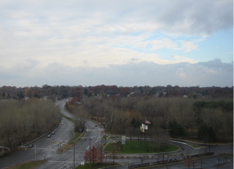
The New York/New Jersey metro area where I grew up and lived most of my life is very different from Wickenburg, AZ, where I live now. So different that I decided to take some photos to try to document some of the differences. I could have done better, but this is what I’ve got to share. This is the view from our hotel room in Teaneck, NJ, on Thursday morning. It had snowed and rained during the night and it was bitter cold that day.

This looks out to the southwest. As you can see, there are lots of tall trees, but they’re pretty much bare in late November. The overall effect is gray. A gray day with gray skies, gray trees, and gray pavement. I hated the gray of the New York metro area in the winter months. But it was the cold that finally chased me out of the area.

Photo

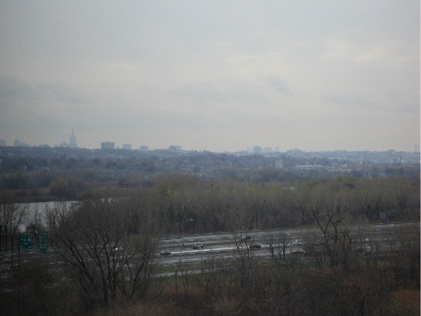
Here’s another look from our hotel room window. This view looks toward the southeast. The highway in the foreground is I-95, which stretches from Maine to Florida. The body of water is some marshland that might just be close enough to the Meadowlands to be considered part of it. The gray buildings poking into the gray sky are the skyscrapers of New York City off in the distance. The pointy one on the left is the Empire State Building, which is now the tallest building in New York again. It formerly held that title from 1934 to 1977, when the World Trade Center was completed. With the WTC gone, this depression-era building is once again the tallest in the city.

Photo

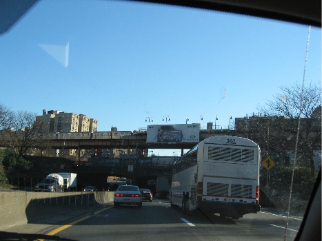
On Friday, we drove to Queens. Here’s a snapshot taken on the Cross Bronx Expressway, which goes from the George Washington Bridge (on the Hudson River), across the top of Manhattan and the middle of the Bronx, to two of the bridges to Long Island: the Whitestone and the Throgs Neck. When I was growing up, this area of the Bronx was filled with burned-out building shells, and we’d often see broken-down or abandoned cars being stripped on the side of the road as we drove through. But the buildings have they’ve since been renovated and people live there once again. Don’t get the idea that this is an up-and-coming area of New York, though. It’s still a poor, crime-ridden area. Ever read Bright Lights, Big City?

Photo

I forgot to take photos the day before, on the way to my brother’s house. We took the New Jersey Turnpike (I-95 down) and there are lots of weird scenic things along that, like the big gas tanks that appeared in a scene of Stephen King’s The Stand and Newark Liberty International Airport. Next time.

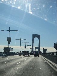
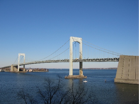
Here’s a pretty poor photo of the roadway on the Whitestone Bridge.

Photo

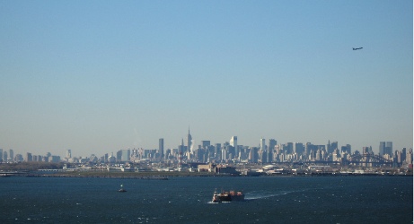
There are three bridges that’ll get you from the Bronx to Queens and Long Island and they’re all pretty similar in appearance: single-span suspension bridges. The Triboro Bridge has some nice art deco touches that make it my favorite of the three bridges, but that one’s much closer to Manhattan, which was out of our way. The Throgs Neck bridge has great views of the Long Island Sound which, in the summer, is full of sailboats and very picturesque. Of course, the Whitestone Bridge does offer the best long-distance views of Manhattan. I took a bunch of photos and this one was the best. It really gives you the flavor of new York from a distance. The tugboat with barge in the foreground, the plane departing La Guardia Airport (out of this shot on the left), and the huge cluster of buildings in midtown Manhattan. You can clearly see the Empire State Building almost dead center and CitiCorp Center (look for the slanted roof to the right). Astoria, Queens is in the foreground, on the other side of the water. And you can just about see the heavy black bridge of the train trestle that parallels the Triboro Bridge. If the World Trade Center were still standing, its towers would appear to the far left in this photo.

Photo

If you’ve never been to New York and you have the opportunity to visit, don’t pass it up. New York is like no other place on earth. As I was telling a Phoenix cab driver just the other day, it’s one of the few U.S. cities that blend old and new in a way that leaves you breathless. Go downtown, to the Wall Street area, and see exactly what they mean by the “Canyons of Wall Street.” The streets are so narrow and the buildings are so tall that light rarely gets down to the street. Although midtown has more tall buildings, the streets are a bit wider. You won’t believe the crowds walking the streets during a weekday lunch hour, the sea of yellow cabs, the bicycle messengers, the street vendors. This time of year, they’re roasting chestnuts near Rockefeller Center and steam is rising from manhole covers and vents on the street.

I do love New York, but I don’t have enough money to live there the way I want to. And New York is one of the grayest places I know.

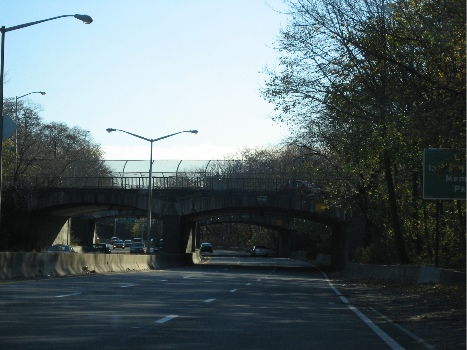
We didn’t get into the city during this trip. Next time I go back, I’ll take some photos. But you might have to wait a few years. Once in Queens, we hopped on the Cross Island Parkway to go to Mike’s Mom’s apartment. I took this shot out the front window of the car. It’s an interesting example of one of Robert Moses’s parkways. He built them all over Long Island — Queens is on the eastern end of Long Island — and this was probably one of his first. One of the trademarks of his roadways was his stone overpasses. They all look pretty much the same, but they’re really nicely executed. When you look at this photo, it’s hard to imagine that tens of thousands of people live within a mile of where it was taken.

Photo

This stretch of roadway is sunken in and surrounded by trees. Mike and I had our first apartment together about 5 miles further down this road, in Bayside. We had a wonderful view of Littleneck Bay (you’ve heard, perhaps, of Littleneck clams?), but had to listen to a never-ending stream of cars going by far beneath our terrace.

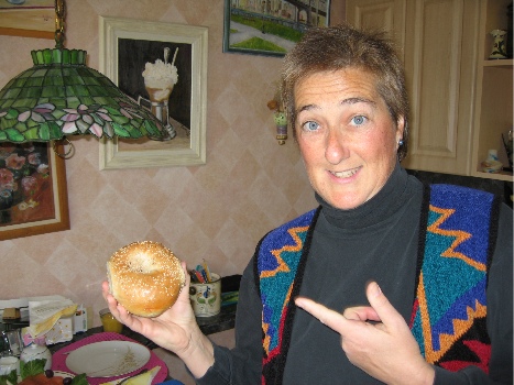
At Mike’s mom’s place, we had bagels for breakfast. This is a photo of me holding a real New York bagel. Notice that it is large and plump. The outside is crusty and the inside is moist and almost doughy. It doesn’t have blueberries or cranberries or any other type of berry in it. This one has sesame seeds (my personal favorite), but they also come plain, egg, poppy seed, salt, pumpernickel, onion, cinnamon raisin, or everything. Everything means seeds, onion, and salt and is a real assault to the taste buds. A common way for a New Yorker to eat a bagel is to slice it open and toast it, then cover each half with cream cheese and slices of lox (smoked salmon). Some people add red onions, capers, and/or tomatoes. (I don’t like tomatoes on my bagels.) A quick spread of cream cheese is referred to as a “schmear” in New York; I prefer a more generous helping. You can’t get a good bagel anywhere outside of the New York metro area, although you can get decent ones here and there. Einstein Brothers makes a decent bagel. Bagels do not come in the grocery freezer section; anything you find there that is labeled a bagel is a mere imitation.

Photo

The next time you go to New York, have a bagel as described above. It’s part of the New York experience and should be required for all serious visitors. And, while you’re at it, take a ride down to the Lower East Side and have a corned beef, pastrami, and tongue on rye sandwich at Katz’s Deli. Get that with mustard. Do not ask for it with mayonnaise; you will be forcibly removed from the premises and publicly laughed at out on the street. A Dr. Brown’s Creme soda is a nice accompaniment — and don’t forget the kosher pickle. Leave the Carnegie Deli for the tourists. What you’ll learn — among other things — is how to properly make a sandwich. There should be more meat than bread. That’s something they just don’t get outside the New York metro area.

But I digress, again. This is a photo of the Throgs Neck Bridge, taken from Mike’s mom’s patio. She’s on the 7th floor and has a nice view out this way. Beyond the bridge is the Long Island Sound. Imagine it with lots of sailboats and you’re imagining the view on a summer Sunday afternoon. Put some green leaves in the tree in the foreground to complete the picture.

Photo

As you can see, it isn’t always grey in New York in the winter. Friday was a very nice day, although it was still bitter cold, with temperatures in the 30s and enough wind to make it feel a lot colder. Of course, it did get gray again on the next day.

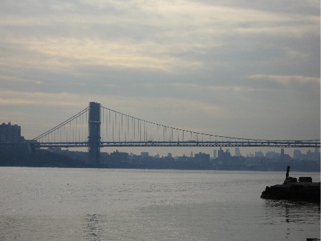
Here’s a look at the George Washington Bridge from the foot of the Palisades. The Palisades, in case you’re wondering, are a line of cliffs along the Hudson River in New Jersey. This photo was taken from a boat basin/park area almost directly across the river from the northernmost end of Manhattan. The view is to the southeast.

Photo

The GW Bridge has two decks — upper and lower — and is a major route between New Jersey and eastern New York. It’s actually the first bridge you get to if you sail up the river from New York Harbor. The next bridge is the Tappan Zee, which is at least 20 miles further upriver. To cross the river closer to downtown Manhattan, you can use one of two tunnels: the Lincoln (midtown at around 30th Street) and the Holland (downtown at around Houston).

When I was growing up in New Jersey, my family had a small boat that we used to take out in the river. I’ve been around Manhattan by boat more times than I can count. It’s a neat trip that you can do on the Circle Line tour boats. We also took a few perilous trips into New York Harbor and around the Statue of Liberty. I say perilous because our boat was really small and the water can get rough out in the harbor. I also remember going past Ellis Island long before it was fixed up and opened to the public. I’ve never been on the island, though.

Anyway, all those boat trips started at the base of the George Washington Bridge, on the New Jersey side. I can still remember the smell of the water at low tide, and the look of all those exposed barnacles. And the way the boat floated up and down as it was loosely tied at the boarding area. We didn’t swim in the river back in those days — it was too polluted south of the Tappan Zee — but we did fish in it, although we never ate any of the fish we caught.

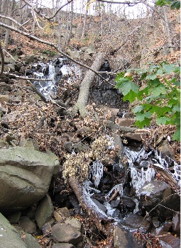
Here’s a shot of one of the “waterfalls” coming down the Palisades to the Hudson River. It’s really probably just runoff from a storm drain, but when we were kids, it was a waterfall and it was one of the most beautiful things we’d ever seen. My family often drove along the river’s shore road on Sunday outings. That’s back in the days when taking a drive in the family car was a cheap and fun day out. There were no malls, no computer games, no cell phones. We’d get in the car and go for a drive and drink up everything we saw out the window. If it was autumn, we’d go to a place called Tices Farms, which had apples and doughnuts (note the spelling) and cider and pumpkins for sale. When I got out of the car to take this photo, the smell of wet leaves brought me back to a time when we would rake them into huge piles and take turns jumping in them. Leave stems would stick in our sweaters and hair and we’d be breathless in the cool autumn sun. I don’t know if you can see it clearly, but there’s ice in the water in this photo. We’re talking cold enough to make a waterfall freeze. Cold.

Photo

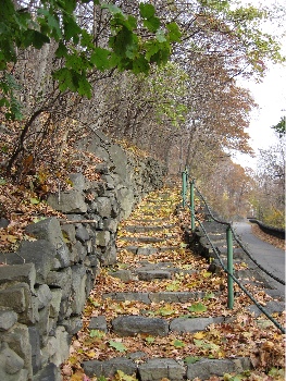
The Palisades area of Bergen County in New Jersey is one of its more historic areas. Originally settled by the Dutch in the 1600s, it was a hotbed of activity during the Revolutionary War. Posted alongside roads all over the area are “Washington’s Retreat Route” signs. Yes. This is the area George Washington retreated from when we weren’t doing very well in the first war with the Brits. Why we need that on signs is beyond me. But the area is also full of walking trails that were probably built during the depression. In more than a few places, you can find stairways and paths that climb the Palisades. This is one example, that follows the road for a short distance before cutting right up the cliff. We did a lot of hiking in the area when we lived there. The views from the top of the Palisades are magnificent.

Photo

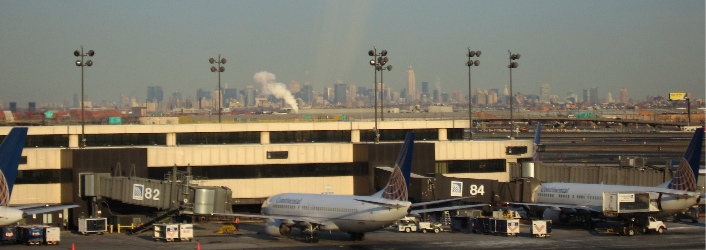
I took the shot that appears below from the AirTrain that travels around Newark Airport. That’s New York in the background.
Photo

This photo reminds me of a visit by one of my editors when we still lived in New Jersey. I picked him up at the airport and was driving north along the New Jersey turnpike toward our house. He looked off to the right as we climbed a bit of highway that passed over the marshes at the Meadowlands and said, “What city is that?” He was looking at New York. That’s when I realized that the skyline I’d grown up with wasn’t nearly as familiar to everyone else.

Am I homesick? Maybe a bit. Would I go back to live there again? Nope.

Been there, done that.

Flying for Food

Mike tries to arrange a group outing for lunch.

We were at Stan’s house on Saturday afternoon when Mike said, “Let’s go fly together somewhere tomorrow.”

Stan’s wife, Rosemarie, and Dave, another local pilot, were there. Stan flies a Cessna 182 and Dave just got a second plane, an RV-4, that he needed to build time in before he could take up passengers. Mike is half owner of a Grumman Tiger.

What followed was a discussion of various responsibilities the next day. We finally decided to meet at the airport at 1 PM and fly somewhere for lunch. The “somewhere” wasn’t decided.

On Sunday morning, during breakfast, Mike and I started to discuss where we could fly. We brainstormed and came up with a list of airports within flying distance that had restaurants nearby:

Restaurants on Field:
– Prescott
– Falcon Field (2!)
– Payson
– Kingman
– Deer Valley
– Glendale
– Scottsdale
– Chandler
– Winslow (weird hours)

Restaurants within walking distance:
– Seligman
– Valle
– Chiriaco Summit (CA)

Restaurants within free shuttle distance:
– Parker (restaurant at the casino)
– Bullhead City (restaurants across river in Laughlin)

Quite a selection. (Note that Wickenburg isn’t on this list. Why someone with a few bucks doesn’t build a restaurant on the field is beyond me. I know why I don’t do it: I’ve already been through the employer nightmare in Wickenburg and have learned my lesson.)

Sunday morning progressed. We had chores to do around the house. We even cleaned a small part of the garage! Then Mike made the fatal error of attacking the mistletoe that had begun killing some of our mesquite trees. (Mistletoe is a parasitic plant and, if not periodically cut out of the trees it infests, it’ll kill the trees.) It was hard work that required him to stand in awkward positions with a heavy saw over his head. After 45 minutes of that, he was too tired to do anything. Including fly.

That didn’t bother me. I wanted to fly anyway. I felt pretty confident that I could get to the destination around the same time as the two planes. Zero-Mike-Lima cruises at 110 knots, but I could easily push it to 120 knots with only two people on board. I’d already called Jim to invite him to join us with his Hughes 500c. Although he wasn’t sure he would, it would be nice to have two helicopters with the two airplanes. I was hoping we’d go to Falcon Field; I really love the Italian restaurant, Anzio’s Landing, on the southeast end of the runway. And there’s plenty of parking right out front.

By the time we got to the airport at 12:40 PM, the wind had kicked up a bit. It was blowing across the runway at about 8 to 10 knots. Airplane pilots don’t like crosswinds. When no one had arrived by 12:55, I got the feeling that Mike’s plan wasn’t going to become a reality.

Jim was already there, working on his Beech 18. He bought the Beech a few months ago in Florida and managed to leak 10 gallons of oil from one of its engines on the ferry flight back to Arizona. Since then, he’d been working on finding and fixing the leaks. He thought he had it taken care of when he flew out to Blythe for some touch-and-goes the other day, but the left engine was still oozing. A bad O-ring on one of the cylinders. He has to pull the cylinder to fix it. In the meantime, he’s begun pulling just about everything else. Last month, he pulled out the floor and replaced it. He’s now waiting for new runners on which to mount the rear seats. Yesterday, when we arrived, he was pulling instruments out of the panel and rearranging them in more logical positions. His helicopter was not at the airport. His wife, Judith, had already said she didn’t want to come with us, so Jim had decided to work on the Beech — something he could probably do for the rest of his life if he wanted to.

Stan and Rosemarie drove up right around 1 PM. I was talking to Jim when they pulled up, so I missed the beginning of their conversation with Mike. But the end result was that they’d come with us in the helicopter. Dave wasn’t coming. So a flight that started with potentially four aircraft ended up with just one.

Of course, with the helicopter, the list of dining opportunities increases. Helicopters don’t need no stinkin’ runway. There were at least five more places we could eat:
The Wayside Inn, near Alamo Lake, is the destination for Flying M Air‘s “Hamburger in the Middle of Nowhere.”
Robson’s Mining World, in Aguila, has a nice little cafe.
– Wild Horse West, near Lake Pleasant, has great burgers.
– The Kofa Cafe, out in Vicksburg Junction, used to be very good, but I haven’t been back since
my first experience with the new owner.
– A truckstop on I-10 south of Vicksburg has a dirt strip out back where you can land and not dust the truckers.

Mike wanted to go to the Wayside Inn, so that’s where we went. You can read all about it in another blog entry. The food ain’t bad and the atmosphere is definitely different, especially if you live in a big city and don’t have much exposure to an off-the-grid lifestyle.

We flew by way of Robson’s, which was pretty quiet that afternoon. Robson’s big anniversary celebration is coming up on the first Saturday in January, and I think they get more visitors in that one day than they get all year long. I do helicopter rides out there during the event and it’s always a lot of fun. Then we followed Ballard Wash (I think) from its narrow start almost all the way to Alamo Lake. I circled the Wayside once, trying to find a flag to judge the wind, then realized there wasn’t much wind there and just set down in my usual spot near the intersection of two dirt roads and the old, unmaintained dirt strip. (If you ever fly out there in a small plane, I recommend landing on the road rather than the strip; it’s a lot smoother and better maintained.) I kicked up a huge cloud of dust that drifted to the east as I cooled down the engine and shut down.

We crossed the road and went into the restaurant. Everyone at the bar looked at us. “I knew it was you,” the waitress said.

“Yeah, well…” I said. Everyone laughed.

We had lunch among the fish photos and trophies. The place was relatively quiet. The last time we’d been in there with helicopters, a crowd had gathered and the restaurant was completely full. I guess having four helicopters and a plane parked outside is a bit of a draw to the locals. But that day it was just us and a man eating at the bar. A few people came and went.

We paid up and left. As I started up, a few people in ATVs parked at the end of the dirt strip, facing us, ready for a show. They were not rocket scientists. Not only had they parked right in front of me, forcing me to depart in a different direction so as not to overfly them, but they were close enough to get seriously dusted when I took off. I took off to the northwest, along the road to Alamo Lake.

We did a tour of Alamo Lake, then the Santa Maria River, and then Date Creek before heading into Wickenburg. It had been a nice little outing — even if we were the only aircraft to participate.

A Trip to Sedona

I spend the day in Sedona, waiting for some passengers.

Yesterday, I had the pleasure of flying two very nice people from Canada from Wickenburg to Sedona for the day. We arrived at Sedona Airport, after a scenic flight around Wickenburg, Prescott, and Sedona’s red rocks, around 11:30 AM — just in time for the Pink Jeep Tour shuttle to pick us up and bring us down to the town. My passengers were taking a Jeep Tour; I planned on just hanging around downtown until they were ready to return at 3 or 4 PM. I escorted them to the Jeep Tour desk, reminded them that they could change their reservation, and watched them reserve a Jeep and driver all to themselves for departure at 1 PM. Then I left them to walk around town on my own.

The Pink Jeep Tour company’s offices are in “uptown” Sedona. That’s the heart of the tourist district in the northwest corner of town at the mouth of Oak Creek Canyon. The tourist shops that line both sides of the street there are dwarfed by the massive red rock formations behind them. But all attention in uptown Sedona is concentrated on those shops. I admit that mine was, too.

I hadn’t been to the town of Sedona for years. I’ve been flying in quite regularly with passengers, but I seldom come down off the mesa where the airport is located. There’s a restaurant up there and I usually have breakfast or lunch or whatever while my passengers explore the town on their own. They’re usually gone about 2 hours at the most, so I busy myself with a book while I’m waiting. It’s a nice, relaxing place.

But yesterday, my passengers wanted a longer stay in town. And since the Pink Jeep people offered me a lift in the shuttle, too, I went down the hill with them.

I walked the few blocks of uptown Sedona at a leisurely pace. I saw lots of T-shirt shops and lots of souvenir shops. The usual collection of real and fake Indian crafts and jewelry. Imported Mexican rugs. Jeep tour companies. Reservation centers. The wonderful map and bookstore that had been in one of the shopping areas was gone and I was sorely disappointed. I’d depended on that shop for reading material while I waited and it didn’t appear, at first, as if there were another bookstore in town. I finally found one across the street from the Pink Jeep storefront, the last shop on my walking tour.

My Sedona passengers from last week’s flight had spent only 90 minutes in town before returning to the airport. They called Sedona a “tourist trap.” And frankly, as I walked the streets, I couldn’t argue with them. But I hadn’t really expected it to be any different. I don’t know what they expected. After all, take a beautiful place, make its beauty well-known, and people will flock there. When enough people flock there, the tourist shops will start springing up like mold on old bread. After a while, those shops (like mold) completely cover the area, masking what people found so beautiful in the first place.

Now I don’t want to give you the idea that Sedona is “ruined.” It isn’t. There are still plenty of beautiful sights around town. Sadly, there are so many people there to view those sites, you’re always part of a crowd. You need to come to Sedona with your own Jeep and a trail map to get away from the herd. Bring a picnic lunch and your camera. And, for heaven’s sake, don’t come on a weekend!

I ran into my passengers on the street just before they went to lunch. They invited me to join them, but I felt as if I would be intruding, so I declined. I had lunch at a tea shop across from the Pink Jeep place and sat outside on a narrow balcony to eat and read the book I’d bought in the bookstore down below. It was windy and rather cold up there, so I didn’t last long.

Afterwards, I went for a walk back the way I’d come. That’s when I saw the Hummer tour sign. They had a 1-hour tour leaving immediately. It was the “Jeep Eater” Tour. Supposedly, this tour took passengers places were Jeeps couldn’t go. I pulled out my credit card and, minutes later, was seated in the front passenger seat of a Hummer, about 6 feet away from its driver. (Okay, so maybe it wasn’t that wide, but it sure seemed like it.) There were two passengers, a couple from Baton Rouge, in the open-air seating behind us. That was it.

The road that Jeeps can’t drive on isn’t in Sedona. It’s halfway back to Cottonwood, off of 89A. It’s a power line road — that’s a road built to maintain a power line — and frankly, there were only about 4 places on the whole ride that I would have been uncomfortable about taking my Jeep. That’s not to say that my Jeep couldn’t have done it. But I’m not sure that it could have done it with me at the wheel. During the whole ride, the driver kept pointing out other roads that the couple from Baton Rouge could explore on their own with the ATV’s they’d trailered up from home. The driver was obviously working hard to add value to the ride and maximize his tip potential. Whatever. It managed to stretch the tour out to 90 minutes, bringing us back to Sedona just when my passengers were due back. In case couldn’t read between the lines in this paragraph, I don’t recommend this tour. It wasn’t worth the $100 I spent on the tour plus tip. But at least I know what it’s like to ride in a real Hummer.

I hurried back toward the Pink Jeep place and found one of my passengers outside a gift shop. His wife was inside, shopping. They’d had a great time and had looked for me to join them before they left. I didn’t tell them about the Hummer.

I left them for a short while to pick up a gift for a friend of mine and a piece of apple pie that was really good. Then we got back on the shuttle, rode up to the airport, and flew home.

I’m glad I got to go to Sedona for the day. I feel all caught up with things down there. And I’m sure I’ll be back soon — not only by helicopter, but perhaps by Jeep to see just what my Jeep can do.

Flight Planning

A quick review of my Part 135 Flight Planning Routine

My company, Flying M Air, is an FAA Part 135 operator. What that means is that I had to go through a lot of paperwork and testing with the FAA to be allowed to take paying passengers more than 25 miles from my starting point or to land with paying passengers on board.

As a Part 135 operator, I have the FAA looking over my shoulder to make sure I do everything “by the book.” The book, in this case, is my Statement of Compliance, a 50+ page document I wrote that explains how I’ll follow the Federal Aviation Regulations (FARs) that pertain to my Part 135 operations. The FAA reviewed this document in painstaking detail and it took about three months to fine-tune it to the FAA’s satisfaction. Of course, the FAA also conducts surprise and scheduled inspections of my aircraft and my base of operations (my hangar) to make sure everything is just right. And because I’m required to be on a drug testing program, I’ve been told that I can expect a visit from the FAA’s “drug-testing police” one day in the future.

For the record, I have no problem following FAA’s requirements for my operation. They’re not asking for anything unreasonable and everything they require is in the interest of safety for me, my passengers, and my aircraft.

Anyway, one of the requirements for Part 135 operations is flight planning. And, at this point, I have it down to a science.

I start by getting the names and approximate weights of the passengers I’ll be carrying, along with our destination, expected time on the ground, and any special route requests.

Today’s a good example. My two passengers want to fly from Wickenburg to Sedona and back. They want a scenic route both ways so they can see as much of the area as possible. At Sedona, they want to take a Jeep tour at least 2 hours long. I’ll have to line that up for them so the Jeep folks meet them at Sedona Airport when we arrive. With lunch and other activities on the ground, I expect to be there 4-5 hours. I expect to depart Wickenburg at 10 AM and depart Sedona by about 4 PM. My route will take them past some of the area’s mining areas, over Prescott, near Sycamore Canyon, and past Sedona’s red rocks before landing. On departure, we’ll swing past Jerome and follow the Bradshaws down to Lake Pleasant, where I can show them some Indian ruins and the house on Sheep Mountain. A final swing around Vulture Peak and over the ranch where they’re staying will get us back to Wickenburg. Total time enroute: about an hour each way.

With this information in mind, I fire up my Web browser and visit the Duats Web site. Duats is a free flight planning service for pilots. I log in and enter my flight plan for a weather briefing that includes current conditions at airports on or near my route (Prescott and Flagstaff) as well as NOTAMs. Today I learned that we’ll have typically clear Arizona weather with the possibility of some high cirrus clouds. It’s windy right now in Flagstaff, with gusts up to 34 knots, but the wind is expected to calm a little bit as the day wears on. Still, I can expect some very light turbulence as the winds pass over the mountains we have to cross or fly around: the Weavers, the Bradshaws, and Mingus Mountain.

Duats also has a flight planning feature and I use this next. It takes the information I’ve already entered to get the weather and uses it to calculate the route and enroute time for the flight. Since I can’t put as much detail into Duats as I need to, its flight plan is much simpler than my scenic route. It says it’ll take 45 minutes to get there and 40 minutes to return. I file both of those flight plans, each with their own times (10 am and 4 pm) with the FAA. They’ll sit in the FAA’s computers until I either activate them (one at a time, of course) or they expire.

Next, I whip out my Manifest form. This is an Excel spreadsheet I designed that automatically calculates weight and balance for my helicopter. I enter all the flight plan information, as well as my starting fuel load and the names and weights of my passengers in the seats I expect to put them. For weights, I add 20 lbs. I used to add 10 lbs, but the folks who book these flights don’t seem to have a clue about weights. It’s always better to overestimate than underestimate. And since it’s nearly impossible to load an R44 out of CG, it doesn’t matter if the two passengers sit somewhere other than the seats I expect to put them in. When my passengers are light — as these two are — I usually put them both on the same side of the helicopter so they have the same basic view. I then fly so that the most interesting views are on their side. But if they both want to sit in back, that’ll work, too. Or any combination they want.

The Manifest form is also designed to be used when I don’t have access to the Internet. It creates the same flight plan that I file with the FAA. So if I have to get the weather from a telephone briefer, I can file my flight plan over the phone at the same time rather than via the Internet.

If I have access to a printer, which I usually do during flight planning, I print out my manifest form for each leg of the trip, my flight plans for each leg of the trip, and my weight and balance for each leg of the trip. If I plan to start each leg of the trip with the same amount of fuel and take the same amount of time, I only print one weight and balance sheet. No sense wasting paper. But today I printed two sheets — I plan to fill up in Sedona since my passenger load is light and fuel is currently cheaper there than in Wickenburg.

I usually give a copy of my manifest — that’s the form with the passenger names and flight plan — to Mike. He’s my backup flight following. I call Mike when I depart and arrive each leg of the trip. If I don’t call in on time and he can’t get me on my cell phone, he takes the next steps with Flight Service.

Of course, I also open my filed flight plans with the local Flight Service Station (FSS). Although I prefer to do this on the ground before I start up, the FSS prefers that pilots do this on departure. My problem is that as a helicopter, I don’t always get enough altitude to access one of the radio frequencies the FSS uses. So I sometimes can’t activate a flight plan until I’m 10 minute into my flight. I close the flight plan by phone when I land, then call Mike to let him know I’ve arrived safely.

All the paperwork that’s generated for the flight is left on my desk in my hangar. After the flight is done, I file it. The FAA likes to look at these papers when they do their base inspection, even though I’m not required to save them.

And that’s about it. As you can see, the whole routine is designed to make sure I properly plan the flight and have at least one form of flight following to make sure a search is conducted promptly if I do not arrive at my destination. It sounds like a lot of work, but I can normally do it in less than 20 minutes with my computer and an Internet connection. To do it manually would take about twice the amount of time.

So I’m flying to Sedona today. I’d better bring a book; I have a feeling I’ll be spending a lot of time at the airport there.