Summer 2016 Road Trip, Day 7: Hozomeen to Copper Creek

A few short hikes and a sweet creekside campsite.

I slept with the camper’s door open (and screen door closed, of course) for the first time. Unlike my other overnight stops, I suspected it would stay warm enough overnight and it did.

I slept really well until around midnight when I woke up with a weird allergy attack. I read until the faucet in my nose turned itself off. Even then, it wasn’t easy to get back to sleep. The frogs were really croaking! I didn’t mind being kept up for that, though. It’s desertlike where I live and there aren’t any frogs.

It was getting light when I woke up. I worked on a blog post, getting it ready to publish, while I had my coffee with some cereal and the last of the blueberries I’d picked a full week before. (It’s amazing how long they stay fresh when you pick them yourself.) By the time I was ready to emerge from the Turtleback for the day, the lake was glassy smooth. I grabbed my camera and shot a few photos of the reflections with the morning sun shining on the opposite shore.

Hozomeen Dock at Ross Lake
One of the boat docks at Winebago Flats. Ross Lake was glassy smooth in the morning.

Meanwhile, the folks who had held my campsite for me were packing up to leave. I thought that odd — they had a canoe on the roof of their car. Surely they didn’t drive all the way down to Hozomeen to just to camp for one night. I said goodbye and thanked them again as they climbed into their car. They turned right instead of left when they left — maybe they were going to put that canoe in the water after all.

I’d already packed up my campsite the night before — it’s important to keep a clean campsite when there are bears in the area — so there wasn’t anything else to do before leaving.

Except take a hike, of course.

The Lakeside Trail

Penny and I set off on the same trail we’d taken to the campground the afternoon before, this time heading downlake. It was wonderfully cool — even the shoreline was in the shade — and quiet. I walked at a good pace, stopping every now and then to look around me and maybe take a photo. I admit that I spent more than my fair share of time wondering if the local bear would put in an appearance; I did see some relatively fresh bear scat along the lake.

Ross Lake near Hozomeen
Along the trail from Winnebago Flats to the Hozomeen Campground boat ramp.

Fork in the Trail
A fork in the lakeside trail at Hozomeen.

I could hear the rushing of Hozomeen Creek long before I got to where the trail split. I knew from the previous day’s hike that the left fork would take us up to the road near Ranger Housing. Where would the right fork take us? To the lake, I assumed. But would there be a bridge across the creek?

Log Bridge
The shorter of two split log bridges across Hozomeen Creek near Ross Lake.

The answer was yes. There were actually two bridges, each of which were created by splitting a log so it had a flat walking surface and then attaching a handrail to it. I was impressed by the first one, but the second one, which had to be close to 100 feet long, blew me away. Had the logs fallen there naturally and then been turned into bridges? Or did someone actually put them in place? I couldn’t imagine getting any heavy equipment in there.

After the bridges, the trail wound down to the boat ramp. And that’s where I saw my two camping neighbors. They were at the ramp with their canoe upside down. The woman was fanning the bottom of the canoe with a foam pad while the man stood by, waiting. Their gear, in dry bags, was neatly organized nearby.

We got to talking (of course). It seems that when they launched the canoe, it began taking on water. They were repairing the bottom with duct tape. Neither of these things surprised me. The canoe looked old and very well used. It had other signs of patches in its fiberglas bottom. And duct tape — well, you use what you’ve got. They were cleaning and drying each area before applying the tape and putting multiple layers on. They seemed pretty confident that their repairs would hold. Then they’d be out for an overnight camping trip along the lake.

We chatted while the woman made the repairs. We talked about the north and south ends of the lake and how Americans had to come all the way up to Canada to launch a boat. We talked about hiking trails in the North Cascades National Park and how US parks had better trails than Canadian parks (their opinion; I didn’t have enough data to come to any conclusion). The conversation inevitably turned to politics. Seriously: Canadians are very worried about Donald Trump becoming president. Even when I tried to steer the conversation somewhere else, it led back. I learned a little more about Canadian politics, too.

Finally, their boat was patched sufficiently and we were all ready to move on. We said our goodbyes and I continued hiking, now up the road to the boat ramp. The previous day, I’d noticed a trail that continued down toward the lake. Maps showed that it went down to a point of land — you can see it in the photo above. So Penny and I plunged back into the forest, in the strip of land between the campground we’d first parked in and the lake.

Pissed Off Squirrel
This was one very pissed off squirrel.

At one point, Penny saw a squirrel and chased it up a tree. It ran up 20 or more feet, then turned and started making really weird little noises at us. I had to record a video. (I just played it and Penny went nuts.)


I’ve never heard a sound like this out of an animal.

We went off the trail briefly to walk down to the lake’s edge. The water was deep right off the shore there with a series of rock shelves that would make a great point for getting in and out of the water. A perfect swimming hole on a hot day.

In the distance, I could see my canoeing friends paddling toward us on the glassy smooth water. I envied them, in a way. It was an absolutely perfect day for paddling and I wished I could be out there, too. I expected them to continue right past me with a wave and final goodbye, but they paddled right up to where I was standing. Then they proceeded to tell me about other places along my route of travel that might interest me: the Othello Tunnels, the wildflower meadow at Manning Park, and the mine tour at Hedley. I committed all of this to memory (somehow), including driving directions and other tips.

Canoeing on Ross Lake
Nice day for a paddle, eh?

At one point, the woman reached down into the water and exclaimed “It’s so warm! Like bathwater! Feel it!” I had my doubts — after all, this was a mountain lake on the Canadian border — but I did as she asked and dipped a hand in. She was right: it was very warm. Seeing people in the water at Winnebago Flats the previous afternoon no longer surprised me.

We chatted a while longer, then all got on our way.

The trail ended at a bench overlooking the lake. Well, kind of overlooking the lake — there were enough trees in front of the bench that sitting at it wouldn’t give you much of a view. I got a last look at my canoeing friends far down the lake, paddling a few hundred feet out from the shoreline.

Penny and I turned around and headed back the way we’d come. Total distance hiked was 2.8 miles. Not bad for an easy morning hike. Interested in a track log with photos? Here you go: Hozomeen Lakeside.

The Othello Tunnels

The Border
The border between the US and Canada is easily visible as a clearing between the two countries. It’s all ready for Donald Trump’s northern wall. Or, more likely, the wall the Canadians would put up to keep out Americans if Trump were elected.

Since we were already all packed up, all I had to do was visit my tiny bathroom — the pit toilets at Winnebago Flats were not something I was willing to face — and close up the Turtleback’s slide. Then we were back in the truck and heading north. I made one stop at the border and that was to take two photos. One was the border sign I showed in the previous day’s blog post. The other was of the actual border, which you can see as a clearing that stretches as far as the eye can see in either direction.

The road north started out smooth and became progressively rougher as I continued north. The more use it got for Canadian parks along its length, the rougher it became. I was glad to reach that sorry excuse for pavement and even gladder to reach the main road in Hope an hour after leaving the park.

I stopped alongside the road and uploaded two blog posts and a handful of track logs. I didn’t bother checking email — nothing of interest had arrived the last time I’d checked. Besides, I was rather enjoying the illusion of being off-the-grid even when I technically wasn’t. Like most connected people, I spend far too much time looking at a computer.

I eventually got on the main road and found my way to Route 3. Then I took the exit for Route 5, looking for the Othello Tunnels. It wasn’t far off my route. I steered my way along a side road and into a very tight parking lot. I was immediately glad again that I’d shed my Mobile Mansion for the Turtleback — I could park in a regular spot. There’s no way I could have parked anywhere nearby towing a virtual house behind me.

The place was crowded with families and people walking dogs — it was a Saturday, after all. It was after noon and I was hungry and not at all in a hurry so Penny and I climbed into the Turtleback and I made myself a nice lunch: sardines I’d bought at Trader Joe’s the previous week with some diced onion on some of that multigrain bread I’d bought my first day in Canada. (It never seemed to go stale.) Then I gathered together my camera and a water bottle and climbed back down into the parking lot with Penny on a leash and headed for the trailhead.

Othello Tunnels Map
Here’s a map of the trail. It actually extended quite a bit past Tunnel 5. You can download the entire map from the park website.

The Othello Tunnels are a series of five old railroad tunnels built into the side of Coquihalla Canyon, a 300-foot deep channel cut in solid granite by the Coquihalla River. They were (and are) an engineering marvel that combined tunnels and bridges, making it possible for the railroad to get through a difficult area instead of having to go around it.

First Othello Tunnel
Penny looked eager to go into the first of the five tunnels.

Although there were a lot of people on the trail, it was plenty wide. It descended at a gentle grade — after all, it had been a train route once — through the woods with plenty of places to look down at the roaring river beside it. The first tunnel began not long after the river entered the gorge it had created. The longest of the tunnels, it got very dark in the middle. A few hikers had flashlights. Penny walked along with me, a tiny shadow at the end of her leash.

On the other end, it was bright and sunny and the river roared through the gorge beside us. The next tunnel started almost immediately. It was a lot shorter and never got very dark. Then there was a bridge and tunnels 3 and 4, which really didn’t have any space between them. Another bridge over the river and then the final tunnel, which had a bend to it.

We walked along at a good pace, stopping between tunnels to look out over the river and gorge. It was a really beautiful place and I tried to imagine what it must have been like to be on a train going along this route. Terrifying, likely, to a passenger.

Between the Tunnels A look into the Gorge
I stopped to take photos between the tunnels — it made no sense to take photos inside them. The gorge was actually quite beautiful. The water gets its color from glacial “flour” — silt in melting glaciers.

Railroad Trail
The trail beyond the last tunnel is mostly in a cut in the granite walls.

We kept walking past the last tunnel. The trail continues on, mostly in a cut that’s canopied, in some places, by fallen, moss-covered trees. Fewer people were on this part of the trail; most seemed to walk through the tunnels and back. We walked as far as another gate, which was also open, and then turned back. The tunnels were darker on the way back because of the direction of the sun, especially that long first tunnel.

Want a track log for this little hike? My GPS said we did more than 3 miles, but I’m not sure how accurate that is since it likely lost contact with satellites inside the tunnels and there are some odd-looking elevation spikes in the track log graph. But here’s what I uploaded, with photos: Othello Tunnels.

In Manning Park

Back in the truck, I headed out, taking a few minutes to chat with my sister (via the trucks’s bluetooth audio) along the way. I like to check in periodically to make sure I’m not missing anything important. I wasn’t.

I lost the cell connection as I headed eastbound on Route 3, the so-called Crowsnest Highway. This road runs a zigzag course through the south end of British Columbia, winding around heavily trees mountains and through valleys. It wasn’t long before the road passed into EC Manning Provincial Park, which must be one of the larger parks in British Columbia. It has lots of trails and campgrounds, and points of interest. It even has a ski resort.

I saw the sign for the Wildflower Meadow and turned left. The narrow road immediately began climbing steeply up the side of a mountain. It went on for a few miles before there was a view point. I was one of about five vehicles that turned in. I let Penny out, leashless, and she immediately began chasing chipmunks that hid in the drainage openings of the curb. It was pretty entertaining for onlookers. The view from up there, at least 2,000 feet above the valley floor, was amazing. A sign pointed out the names of various peaks, including Hozomeen Mountain (which looked very close) and Mount Winthrop, both of which are in the US. Far below us, I could see the resort area for the park, with its restaurant, lodging, and other amenities.

From Manning Park
The view from the overlook on the road to the Wildflower Meadow at Manning Park.

Penny and I continued the climb. There was a trailhead parking area and we kept going. Then the road ended at another trailhead. Parking was tough, but I found a spot alongside the road. I put Penny on a leash and we set out to explore the Paintbrush Trail.

Wildflower Meadow Sans Wildflowers
There weren’t many wildflowers at Wildflower Meadow, but there was a massive antenna installation and an even better view. This is looking southeast.

The trail likely gets its name from the only flower still blooming: Indian Paintbrush. But even those had already faded. Between the cold nights at that elevation — over 6,000 feet — and the lack of rainfall, the flowers were already gone. I imagine it must be something in spring or early summer, but at the end of the first week in August, it’s a bust. (My canoeing friends warned me that it might be too late in the season for flowers.) We did a short hike anyway — maybe a mile — and admired both the view and the massive antenna array that guaranteed me a cell signal. Then we went back to the truck and retraced our route down the mountain.

Copper Creek

By this time, it was after 5 PM and I was starting to think about a place to spend the night. My trip planning had pretty much ended the day before and now I was making up everything as I went along. So I started by driving into the resort area, following a sign to Lightning Lake campground. That was full, but there was a ranger at the booth and I asked her about camping possibilities. She told me that camping in the park is only allowed in designated sites and that there might be a few available in other campgrounds. She gave me a map and circled three of them, two of which were on my route east. I thanked her, turned around, and headed back out to Route 3.

I skipped the first campground, mostly because it was right on the main road, and pulled into the second one, which was about 10 kilometers from the resort turn. This one was almost full. There were two sites that weren’t reserved or taken and both were on the main road. The idea of paying $25 to camp in such a full campground so close to a highway really bugged me. So I left and we continued on our way.

We passed out of the park. I looked for camping possibilities. I suspected I’d have to go off on a side road, but I had no idea where to try. A bunch of signs warned about road work and flagmen up ahead so I slowed down. I got to a bend in the road where a woman was turning around a truck at an intersection where a gravel road went off to the right. There were lots of road work signs. I stopped beside her and rolled down my window. “Are you a pilot car?” I asked.

She looked surprised. “No,” she replied.

I pointed down the road beside us. “Where does that go?”

She gave me a huge shrug. “I don’t know, but Copper Creek is down there.”

“Any camping?”

“I don’t know,” she said.

I thanked her and let her pull away. Then I turned right down the road toward Copper Creek.

The road was obviously a logging road — signs at the beginning provided information about radio calls and warned, “No seatbelt, no job.” I proceeded cautiously. I didn’t have far to go. About a quarter mile down the road was a bridge over a creek. And right before the bridge was a clearing with a picnic table and fire pit. No, two picnic tables with firepits. I slowed to a stop and looked at the sign: Copper Creek Recreation Area. I turned in.

It was a tiny campground with 5 sites, three of which were right on the creek, and a pit toilet. No one else was there. The $12 fee would be collected by “an attendant.”

At Copper Creek
My campsite at Copper Creek. The creek is right beyond the trees to the right of the Turtleback.

After scouting the area — including some minor road damage from erosion — I chose a campsite and backed into it. I had trouble getting the Turtleback level and wound up backing up almost all the way to the picnic table. When I was satisfied with what the level said, I put the truck in park and shut it off. (Unfortunately, I misread the level and we were camped on a bit of an angle for the night. I have since ordered leveling blocks.) I let Penny out and went about setting up my grill to make dinner: sausages with salad and garden tomatoes.

The site, which was about 10 feet from the creek, was extremely pleasant with the sound of flowing water. If the road was for logging, either the loggers were done for the day or had the weekend off. No other campers showed up. No attendant showed up, either. I had dinner outside at the picnic table, and then, when the sun dipped below the trees, I went in for the evening.

I didn’t realize it then, but it would be my last night on vacation.

The Sun Shades

A solution to a “problem” I’d hoped I wouldn’t have.

On May 20, 2014, I began blogging about the construction of my new home in Malaga, WA. You can read all of these posts — and see the time-lapse movies that go with many them — by clicking the new home construction tag.

Earlier in June, I finally broke down and ordered sun shades for my home.

My living space has 15 windows, 11 of which are 4 feet wide by 5 feet tall and, as positioned, offer a nearly unobstructed view of what’s outside. (The others 4 are 6 feet wide and 3 feet tall up near the ceiling facing south.) Because I have no close neighbors and no worries about people looking in, I don’t have any curtains or shades. The result: my home is very bright with natural light during daylight hours.

Great Room at First Light
My great room, looking west northwest, shot from my desk at first light. The number and placement of windows offers an almost unobstructed view of what’s outside beyond my deck.

This isn’t perfect, however. (What is?) While the 7 north-facing windows are shaded by the roof over my deck on that side, the 3 east-facing and 1 west-facing windows are not. This time of year, I get a lot of direct sun into the east windows in the morning and into the west window in the afternoon. Although this tends to raise the temperature in my living room (morning) and bedroom (afternoon), that’s not really a problem — my air conditioning and ceiling fans can handle that. What is a problem is that I can’t work comfortably at my desk in the morning with the sun shining in my face. I’m also slightly concerned about the affect of direct sun on my living room’s red leather sofa and bedroom’s brown leather sofa and the various antique and heirloom items I own.

Solution: sun shades: shades that offer some filtering of the sun without completely blocking out the view. These are extremely popular in Arizona, where the sun can be brutally strong, especially in the summertime. I had a set at my home there for afternoon relief on the west-facing downstairs patio. Those were off-the-shelf roll-up shades from Home Depot that were admittedly cheap and ill-fitting but did the job. I’d want something a lot nicer for my new home.

In the past, I’ve ordered blinds from Select Blinds, a great source of blinds, shades, and other window treatments. This is where I ordered faux wood blinds for the little windows in my Howard Mesa cabin in Arizona and cloth vertical blinds for the sliding glass doors on the Phoenix condo. These folks do great work at a good price. There’s always a sale or special deal.

This time around, I ordered inside mount sun shades that filtered out only 14% of sunlight, thus letting a lot of light through. I’d be able to see through them, even when they’re down. I figured I’d put them on the 3 east and 1 west windows and use them in the summer. If they were easy to remove from the mounting hardware, I’ll likely remove them for the rest of the year. I don’t want anything blocking my view.

What I liked a lot about the blinds I chose is that they didn’t have to be wound up or down with a cord. They were spring-loaded, just like the blinds my parents had in our house for privacy back in the 1960s. You could pull them down in any position and with a tug, let them retract back up. No cord to worry about getting sucked into my Roomba or tangled into the power cord for my router or TV.

As usual, there was a special deal. (Deals aren’t really “special” if they’re always available, but I’m not complaining.) This time it was 35% off plus an additional 10%, 15%, or 20% off depending on the order total. My order of four custom-sized blinds — each window opening is a little different, thanks to the slap dash nature of the window framing — qualified for the extra 15% off, bringing the order total to just $370, including shipping. I sincerely doubt I could have gotten a better deal locally

Weeks went by. I was out working in my garden when the FedEx Ground truck came and dropped off a long box. My blinds.

I got to work the next day. The first chore was to finish the seal between the window and drywall. Although the drywall guys had done a great job hanging a lot of drywall in my home and fitting it around windows to create the box-like effect I have, they did a crappy job of finishing. I had to buy paintable caulk, run beads in the joints, and smooth it with a neat little caulking tool I have just for that purpose. A bit of paint once the caulk had dried finished the job.

Bad Finish Better Finish
Left: typical bad joint between drywall and window frame. Most of my windows were like this. (Apparently, the general contractor (me), was supposed to hire a finish guy. Who knew? I guess I’m that guy.) Right: joint between window and frame after applying and smoothing caulk. A bit of paint made it perfect.

Drywall Anchor and Screw
An example of a drywall anchor and screw.

Installation of the blinds was easy. Although I used the mounting brackets they came with, I could not use the screws. I needed drywall anchors, since the screw positioning did not connect with any of the studs. No problem — I had suitable drywall anchors with corresponding screws leftover from another project that didn’t need the anchors. I measured and marked, drilled holes, tapped in anchors, positioned brackets, and screwed in fasteners. (Any job is easy when you’ve got the right tools.) Using the tags in each blind bag, I matched the blinds to the windows. There was a bit of a challenge getting the middle east blind in — they were all a tight fit — but some creative use of a hammer resolved the problem.

Blinds Down
With the blinds down, plenty of light comes through and I can still see what’s outside. Although the blinds are long enough to go down to the windowsill, I typically only lower them to the part that opens so air flow is not restricted.

Blinds Open
When the blinds are open, the roller at the top of the window frame is nearly invisible, so I don’t have to look at them at all.

The result was perfect — exactly what I wanted. Actually, even a little better, as these two photos of two east side windows illustrate.

When the blinds are down, the light is filtered just enough. I can sit at my desk and work comfortably to get things done, but there’s still plenty of that morning light to illuminate the room. And I can see right through the shades for a sort of gauzy view of what lies beyond.

When the blinds are up, they roll tightly to the top of the window. Because I chose a neutral color — a sort of linen white — they are nearly invisible. No need to remove them in the winter months — which is good because the hardware would be very noticeable without them. This is a total win-win for me because I really don’t want to see any window coverings on any of my windows unless they are in use. I don’t believe in “dressing” a window when the real beauty is outside.

Of course, I only need the blinds down on the east side in the early morning — say before 10 AM — starting about a month before the summer solstice and ending about a month afterwards. The same goes for the one west side window in my bedroom for the afternoon — say after 4 PM — although I tend to keep that one down all day long because I’m not usually in that room during the day.

In all, I think I found the perfect solution to a “problem” I was hoping I wouldn’t have. The sun shades do the job, look great, and weren’t outrageously expensive.

This is only one of the challenges I’m facing and working through as I put the finishing touches on my home. The loft rails, which I finished this past winter, was another. Coming up is a big one: the stairs to the loft. Now that I have all the materials I need to start working on them, I hope to be blogging about that soon.

Creating Defensible Space

Fire season is serious business in the west.

Every fire season seems to get a little worse in the west — particularly in the Pacific Northwest where I now live. For the past four summers, we’ve had widespread wildfires, most of which were started by lightning strikes. Fires have been particularly threatening, if not downright damaging, near my new home:

  • In September 2012, lightning strikes started over 100 wildfires from Blewett Pass to Lake Chelan. Visibility dropped down to less than 1/2 mile in smoke and mandatory evacuations affected the Wenatchee Heights area that was my temporary home not long after I left for Arizona.
  • August Fire
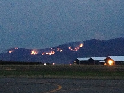
    I was at a party at the airport on the evening of August 10 while Jumpoff Ridge was burning.

    In August 2013, lightning strikes started a handful of fires on Jumpoff Ridge, the cliffs that tower behind my current home. Although I’d just purchased the land and didn’t have anything on it, I was as alarmed as my neighbors when my road was put on mandatory evacuation, mostly because firefighters feared that burning debris would tumble down the cliffs and start new fires on our level. (Fortunately, that didn’t happen.)

  • In July 2014, more than 300 homes were destroyed when a fire hit the community of Pateros, about 45 miles upriver from Wenatchee. Other fires up the Methow River near there destroyed forests, orchards, and a few more homes.
  • Sleepy Hollow Fire at Night
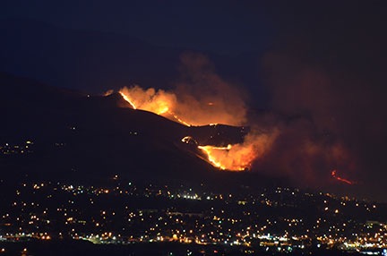
    I shot this photo of the Sleepy Hollow Fire on the night of June 28, 2015 from my deck using a 300 mm lens. It isn’t cropped. Although the fire was more than 8 miles from my home, I found it terrifying and could not sleep that night. A pair of heavy rainstorms the next day put the fire out — and started the Wolverine Fire up near Lake Chelan that’s still burning today.

    In June 2015, the Sleepy Hollow fire destroyed more than 20 homes in a Wenatchee subdivision overlooking the town. Burning embers from the fire traveled on the wind and touched off fires a half mile away, destroying 3 warehouses and fruit packing and storage facilities.

As I write this, there are dozens of fires all over Washington, Idaho, and Oregon. These fires are growing at alarming rates. The Okanogan Complex Fire, for example, started on Saturday, August 15 — that’s just 8 days ago — and has already grown to 227,206 acres. That’s 355 square miles — larger than the entire city of New York (all five boroughs).

Can you imagine all of New York City burning in a week?

And that’s just one of the monster fires. Chelan Complex has burned 87,412 acres in the Chelan area, North Star has burned 132,000 acres on the Colville Indian Reservation, and Grizzly Bear Complex has burned 59,150 acres in the Umatilla National Forest. The Interagency Inciweb website is currently tracking 26 fires in Washington State alone. The President has declared Washington a disaster area. This is some serious shit.

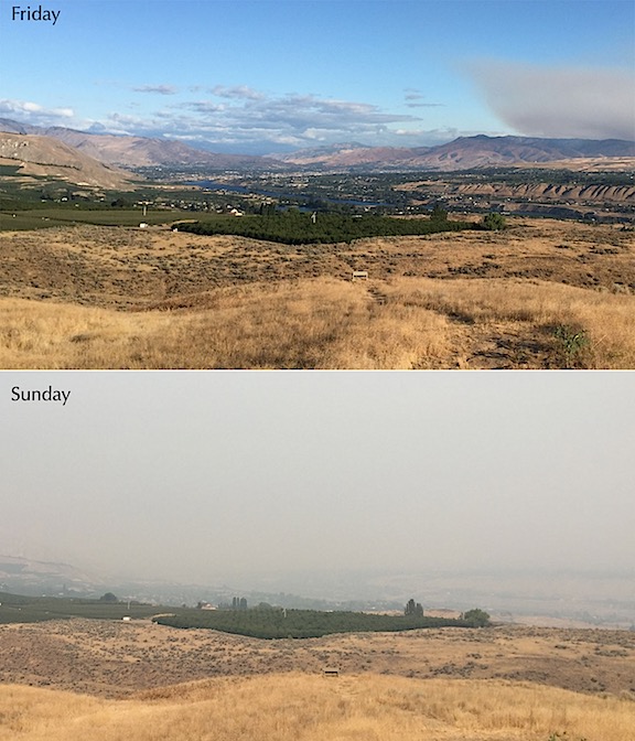
Although the closest fire is at least 20 miles from here, a wind shift has brought smoke into the valley. Visibility is less than 3 miles — I can’t even see the airport from my home. The smell of smoke is in the air. I spent much of yesterday outdoors doing light work and wound up with a sore throat from breathing smoke.
Visibility.jpg
On Friday, the air was very clear, although I could see the smoke cloud coming our way. This morning, the air is thick with smoke. I can barely see the buildings at the airport just 3 miles away.

The scariest part of fire season for those of us who live on the outskirts of town, surrounded by natural vegetation, is the fact that it doesn’t take much to start one of these crazy fires. Lightning is the most common cause, but fires have also been started by cigarette ash, sparks from chainsaws or mowers or ATVs, and even cars with hot engines parking on tall, dry grass. If Mother Nature doesn’t start a fire, some careless idiot might.

As you might imagine, the idea of “defensible space” is on many people’s minds. In theory, it means keeping enough clear area around your home so that firefighters can defend it from wildfire. That usually means cutting down trees and bushes and trimming long grass, surrounding your home with heavily irrigated vegetation such as green lawns or orchard trees, and removing any firewood or scrap wood piles near your home. If your home does not have defensible space, not only is it more likely to burn in a wildfire, but firefighters may not even try to defend it because of the danger it could put them in.

I did much of this over a month ago when I used my string mower to cut back the tall, dry grass on the side and back of my home. I debated cutting a few of the small sagebrush in the area — they burn hot and fast when ignited — but left them. The other two sides of my house have concrete and gravel and a small lawn.

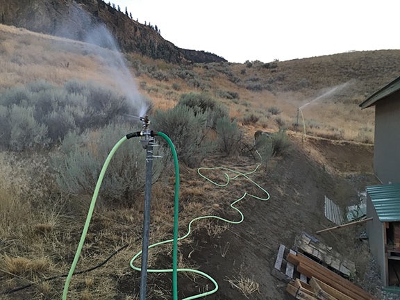
Of course, some of us take it the next step by installing sprinkler systems that can be turned on, when needed, to soak the area. I did that the other day. I drove two 6-foot T-posts into the ground, one at each corner on the road side of my home. Then I fixed 50-foot sprinkler heads to the top of each one. I ran hose from my shed — which has extremely high water pressure — to the first sprinkler and another hose from that one to the second one. When I turned them on, they provided coverage along the entire road-side of the building, as well as about 50 feet down the front and back.
Sprinklers
Here’s my sprinkler setup on the road side of my home. I do need to move some of the scrap wood there, or cover it with some of the metal panels I have.

I want to add a third sprinkler to the roof of my shed, which would protect the shed and chicken coop. A fourth sprinkler head can be mounted on my deck in the other back corner of the building to provide some protection there.

My friends have been asking me whether I have a generator for the water pump. They assume I have a well. I don’t. I have city water which should keep flowing as long as the water company keeps it coming. I guess I should hope that they have generators.

Yes, I know it isn’t perfect, but it’s better than nothing.

The good thing is, my building is made of metal. So flying embers landing on the roof or against a wall should not be able to start a fire. There are some exposed wood beams, however, and I’m not fooling myself into thinking the building is fireproof. As too many folks around here have learned over the past few years, even metal buildings can burn if they’re subjected to enough heat. My goal is to prevent that heat from getting close enough.

I’m not the only one thinking about fire. Kirk has moved his vehicles into his orchard, which is far less likely to catch fire if fires come through the canyon where he lives.

Anyone who lives in an area prone to wildfire damage who doesn’t create defensible space around their home is an idiot, plain and simple. As we’ve seen this year, even homes in subdivisions that are normally safe from wildfire danger can be completely and utterly destroyed. Why would anyone fail to take steps to protect their home before such protection was absolutely necessary?

When the fires come, you often don’t have time to act before evacuation. I feel a bit of comfort knowing that I can get my sprinklers going in a matter of minutes now because they’re already in place. This might mean the difference between keeping my home standing and losing everything I own.