A Few Desert Gigs

I spend two Saturdays doing rides in remote desert locations.

One of the things I like to do to earn a little money with the helicopter is short rides at outdoor events. We did great at the Thunderbird Balloon Classic back in October, but that was held down near Phoenix and attended by people with money to burn. Up here on the edge of nowhere, people are a little tighter with their hard-earned money. As a result, I have to price the rides affordably and give each passenger a lot of bang for the buck. The margins are lower at these outdoor events, but I get a lot of satisfaction giving people their first helicopter ride or showing them something they can only see from the air.

The past two Saturdays each had gigs like that.

On December 30, I flew at the ghost town of Stanton. Stanton was a mining town established in the 1800s. At one point, it was a thriving community, with an opera house, hotel, and stage stop. Situated at the foot of the Weaver Mountains alongside Antelope Creek, it was a gold mining community. Legend has it that a man looking for a lost burro climbed to the top of what would later be known as Rich Hill and found gold nuggets the size of potatoes. Like any idiot from that time, he couldn’t keep quiet about his find and, before long, miners were flocking to the area to cash in. The town grew. It was named after a man named Stanton who, I believe, was involved somehow in the Wickenburg Massacre. (More on that another time.) The town was eventually abandoned when it became too difficult or costly to pull out more gold. Later, a group called the Lost Dutchman’s Mining Association bought the townsite. They installed caretakers, which prevented the town from being vandalized like most ghost towns in Arizona were. (For example, there’s really nothing left of nearby Octave, another ghost town.) As a result, the Saloon/Opera House, hotel, and stage stop still stand. They’re actually in use to this very day, maintained by the Lost Dutchmen group. And a campground has sprung up around the property, giving the group members a place to camp out during the winter months.

I’d flown at Stanton before and although it wasn’t a lucrative gig, it made a small profit and was a lot of fun. The Lost Dutchman have “outings” at Stanton a few times a year. The year-end outing is the big one. Everyone wants to see the “Potato Patch” at the top of Rich Hill but no one wants the all-day hike to get up there. I can get them up there and back in 8 minutes, so that’s what I did.

Flying at Stanton
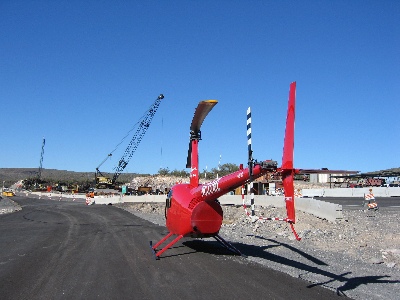
So on December 30, at 12:30 PM, I arrived at Stanton as scheduled and landed on a seldom-used road near the campground. My ground crew — Mike, John, and Lorna — got out and set up a little table. I shut down and waited for the crowd to gather. They came in pairs and trios and when I had at least 4 people waiting, I started up again. Lorna took the money — $30, including tax, per person. Mike and John gave the safety briefings and loaded up the passengers. Then I took off toward Wickenburg, climbing, climbing, climbing. I rounded the south end of Rich Hill and climbed up its east side. The passengers had excellent views of what was left of Octave and the mining activity going on in that canyon. Finally, 2000 feet above Stantons’ elevation, I rounded the north end of Rich Hill, still climbing. We were over the next valley, with Stanton far below us in the mouth of the canyon. I pointed out the Potato Patch and the miner types oohed and aahed. I started the descent, coming down at a rate of more than 1,000 feet per minute. On the way down, I pointed out Wickenburg, far to the south, and Congress, to the west. Also, North Ranch (which, you may recall, the management claims occupants are too old for helicopter rides) and the dairy farm. Even at a 1,200 feet per minute descent rate, I can’t get to Stanton without overflying it and turning back, making an elongated spiral to my landing zone.

We flew 22 people that day. Not bad for a gig less than 15 miles from Wickenburg. Even with a side trip to Lake Pleasant before the flight, we made some money.

On January 7, I was back in the desert with my ground crew. This time, we went to Robson’s Mining World in Aguila. This was my third gig out there for their anniversary celebration. Every year was a little better and this year, I’d dropped my price from $35 per person to only $30. I think that made a big difference. We gave about 50 rides.

The setup for this event was a little more deluxe. Robson’s was having its annual Anniversary celebration and they had lots of activities and food and vendors inside their “town.” John and Lorna took their truck out there, so we were able to bring a long a lot of extra supplies. Flags, banners, a table, some extra fuel. Our setup, alongside the road, was very noticable, especially since we got there early enough to keep the space in front of our table clear of cars.

Flying at Robson's Mining WorldI flew for a few hours, taking a break for lunch before starting up again and flying some more. The route started from our desert clearing, which was just big enough for Zero-Mike-Lima to fit comfortably, to the east alongside the base of the mountain behind Robson’s. I climbed as I flew, pointing out where Wickenburg would be if we could see it (we couldn’t), Vulture Peak, Congress, and Alamo Lake if we could see it (we couldn’t). Then I came along the back side of the mountain, crossing over a saddle on the west side. (There were a couple of guys and a dog working an old mine shaft up there and I wonder what they think of the helicopter flying over them every 10 to 12 minutes or so.) I came through the canyon where Robson’s is nestled, pointing out the trail to the petroglyphs along the way. I flew jsut to the east of town, where everyone could see me but not be bothered by the sound of the helicopter, before circling around to land back in my LZ.

The passengers were all thrilled. They always are. It’s a rewarding job.

When it seemed as if we were done and the event was winding down, I shut down and took a walk with Mike, John, and Lorna to enjoy the event. The crowds were gone and it was pleasant. We bought $1 ice cream cones (brings back memories, doesn’t it?) and watched the old engines run out back.

Later, when we were ready to leave, there were a few people gathered around the helicopter taking photos. Two men who were part of a party of three people wanted rides. Since they were going back to Wickenburg, I offered to take them there for the same $30 each. (That’s where being a Part 135 operator really pays off; I can do that kind of stuff.) They agreed and while their friend drove to Wickenburg, we took off, overflying Robson’s one more time as we headed back to Wickenburg.

I should be doing similar events like this down in Buckeye and up in Yarnell over the next few months. I’m hoping to pick up a few new gigs in the meantime.

If you’re reading this in Arizona and think you have at least a dozen people interested in taking rides at $30 to $40 per person (prices depend on distance to the gig), give me a call. You can learn more at the Flying M Air Web site.

Two Interesting Charters

I find that there’s more to flying helicopters than giving tours.

Lately, I’ve been getting calls from folks who want to use my helicopter for more than just transportation or tourism.

The first good assignment I got came a few months ago, when I flew a camera crew around the a carmaker’s test track in Arizona. I wrote about it in another blog entry. This past week, I did two more.

The first, on Tuesday, was for a professional photographer hired to take aerial and ground photographs of the new bridge being built over Burro Creek on state route 93. There’s already a beautiful bridge there and the construction crew is building a twin on the north side of it (the road runs pretty much east-west there). Burro Creek runs in a deep canyon there and the Sonoran desert landscape is breathtaking. The site is also far from civilization — about 55 miles north of Wickenburg and perhaps 20 miles south of Wickiup.

It was a cold morning when we left Wickenburg, so I left the helicopter’s doors on. It took us about 30 minutes at my top cruise speed (110-115 knots with two on board and full fuel) to reach the site. I set down in a fenced-in area where the construction folks were storing cactus to be replanted after work was done. I took the passenger door off while my client got his camera equipment out — a pair of Hasselblad medium format cameras with three different lenses. A construction truck pulled up and my client got out to talk to the driver. He came back and told me that the next time I landed, I could land on the new road right near the bridge. It was closed to traffic and was smoothly paved. We took off and began circling the bridges from various altitudes. My client snapped away, cranking the camera’s advance do-dad after each shot. He was perfectly at ease leaning out the door; he’d flown in many helicopters before. After about ten of fifteen minutes of that, I set down on the road near the bridge and shut down. (I had to set down on the edge of the road, as shown in the photo below, because the road was banked for a curve and the only real level spot I could find was at the very edge of the road.) My client climbed out, filled a smaller camera bag with equipment, and walked off to take his ground shots.

I pulled out my iPod and a book and settled down on the side of the road to read. Cars and trucks drove by and I wondered how many of them were headed to or from Wickenburg.

He was gone about 90 minutes. When he returned and finished fiddling around with his equipment, we climbed back on board and I fired the helicopter back up. The light had changed, so we did another 10 or 15 minutes of circles around the bridge at all different altitudes. Then he told me to head back and I broke off circling and headed back.He took some more photos on the way back — using up extra film on shots he thought he might be able to sell the construction folks. Then we set down on Eric Barnes’s dirt strip, on route 93 near the Santa Maria River, so I could put the door back on. With the door off, it was loud and my speed was limited to 100 knots. With it on, it was quieter and I could get it up to 120 knots. When we got back to Wickenburg, I’d put 1.4 hours on the Hobbs. My client paid for that, as well as for some waiting time.

Two days later, I was in Aguila, doing a job for the maker of a “breadcrumb” communications system. Breadcrumb systems, as they were explained to me, create a wireless network that can be used for voice, data, or video communications. The folks who hired me had an impressive system they wanted to mount in the helicopter. The idea was to have me fly around with the system and a few techs on board to see how well the system stayed connected to other breadcrumbs on the ground and how well video that one of my passengers shot could be seen at ground-based stations.

As the photo here shows, I had to remove both doors on the pilot side so they could mount the unit’s antenna. The breadcrumb box itself was positioned at the feet of the passenger behind me; you can barely see it in this photo because it’s just a flat box standing on one end. Although the unit can be powered by batteries, my helicopter has a 28 volt DC port that looks like a cigarette lighter port. The breadcrumb had a cable that could take this voltage, filter it, and step it down to the 12 volts it needed. So they just plugged it into my DC port. The boss of the operation wasn’t happy about the positioning of the antenna — he wanted to dangle it somehow under the helicopter’s body — but we soon proved that it was fine.

One of the techs also had a GPS and, at first, they wanted to mount it on my tailcone. They claimed that in the work they’d done with RC helicopters, they’d found that there was too much interference from the main rotor disk for the GPS to get a good signal. When I told them that my handheld GPS worked in the cockpit cabin, they decided (to my relief) to give it a try. (For the record, I would not have let them mount it on my tailcone. That’s much too close to the tail rotor! We might have mounted it on a skid if we had to.)

My passengers climbed aboard and we took off, flying circles around their base of operations at Robson’s Mining World. One guy in the back did the video while the guy beside him kept reporting on the status of the breadcrumb: green, blinking green, green, green, etc. We kept in touch with other breadcrumbs on the system at all altitudes and even when we flew behind a mountain. We only lost touch once, and that was for only a few seconds. The video went down to the guys on the ground, who clustered around a laptop set up on the hood of a car in the parking area. We did this for about 20 minutes, then landed.

I didn’t realize it then, but I was done with my assignment. What followed was about an hour spent giving everyone there a ride. I took them three at a time and did a 4-minute ride around the base, climbing up the mountain behind Robson’s and descending back into the desert for landing in my designated landing zone. When everyone had their ride, they told me to shut down and have lunch with them. Some other folks would be taking photos of the setup while I was eating.

I ate outside, with the guys from Rotomotion. They build RC helicopter systems to be used for surveillance and unmanned observation. The company founder started the company when he got frustrated that he couldn’t fly an RC helicopter. (Having owned one for a while, I know exactly how he feels; I couldn’t fly mine, either.) He wrote a computer program that would fly the helicopter for him. His company now builds helicopters that work with his Linux-based software system. They had three helicopters with them: a small electric model (on the table in this photo), a medium diesel model, and a large model powered by a chain saw engine.

The software is extremely cool. Once the helicopter is airborne, the software takes over and can hold it in an absolutely perfect out of ground effect hover. You can also tell it to go to certain coordinates at a certain altitude and it’ll go. It uses wireless communications to control an onboard camera or other equipment. If it loses its radio control signal, it’s programmed to return to its home base. Although they have a routine for software-controlled take off, they need a reliable but small altimeter to judge distance from the ground before a good landing program can be written. I have no doubt that they’ll add this feature soon. These guys definitely know what they’re doing.

While the rest of the group went off to go shooting out in the desert, a small group of us remained to watch the RC helicopters fly. A police officer from Chandler had come up to get a demonstration and we just watched. He said that the system has many applications in law enforcement and he seemed excited about it.

I went home a while later and put my dusty helicopter away. I’d logged 1.6 hours for the assignment — not much, but enough to make it worthwhile. And the technology I’d seen while I was out there was well worth the time spent.

A Trip Back East

Some photos from a trip back to New Jersey and New York for the Thanksgiving Holidays.

I didn’t want to go, but Mike talked me into it. Then we made flight reservations before I could change my mind. It would be a short trip. I’d fly out on Wednesday and return on Saturday. Only three nights, and those would be made comfortable with a room at the Glenpointe Marriott in Teaneck, NJ. Dinner with my family at my brother’s house in New Jersey on Thursday, dinner with Mike’s family at a restaurant in Queens on Friday, Dim Sum with family and friends in Ft. Lee, NJ on Saturday morning.

The New York/New Jersey metro area where I grew up and lived most of my life is very different from Wickenburg, AZ, where I live now. So different that I decided to take some photos to try to document some of the differences. I could have done better, but this is what I’ve got to share. This is the view from our hotel room in Teaneck, NJ, on Thursday morning. It had snowed and rained during the night and it was bitter cold that day.

This looks out to the southwest. As you can see, there are lots of tall trees, but they’re pretty much bare in late November. The overall effect is gray. A gray day with gray skies, gray trees, and gray pavement. I hated the gray of the New York metro area in the winter months. But it was the cold that finally chased me out of the area.

Photo

Here’s another look from our hotel room window. This view looks toward the southeast. The highway in the foreground is I-95, which stretches from Maine to Florida. The body of water is some marshland that might just be close enough to the Meadowlands to be considered part of it. The gray buildings poking into the gray sky are the skyscrapers of New York City off in the distance. The pointy one on the left is the Empire State Building, which is now the tallest building in New York again. It formerly held that title from 1934 to 1977, when the World Trade Center was completed. With the WTC gone, this depression-era building is once again the tallest in the city.

Photo

On Friday, we drove to Queens. Here’s a snapshot taken on the Cross Bronx Expressway, which goes from the George Washington Bridge (on the Hudson River), across the top of Manhattan and the middle of the Bronx, to two of the bridges to Long Island: the Whitestone and the Throgs Neck. When I was growing up, this area of the Bronx was filled with burned-out building shells, and we’d often see broken-down or abandoned cars being stripped on the side of the road as we drove through. But the buildings have they’ve since been renovated and people live there once again. Don’t get the idea that this is an up-and-coming area of New York, though. It’s still a poor, crime-ridden area. Ever read Bright Lights, Big City?

Photo

I forgot to take photos the day before, on the way to my brother’s house. We took the New Jersey Turnpike (I-95 down) and there are lots of weird scenic things along that, like the big gas tanks that appeared in a scene of Stephen King’s The Stand and Newark Liberty International Airport. Next time.

Here’s a pretty poor photo of the roadway on the Whitestone Bridge.

Photo

There are three bridges that’ll get you from the Bronx to Queens and Long Island and they’re all pretty similar in appearance: single-span suspension bridges. The Triboro Bridge has some nice art deco touches that make it my favorite of the three bridges, but that one’s much closer to Manhattan, which was out of our way. The Throgs Neck bridge has great views of the Long Island Sound which, in the summer, is full of sailboats and very picturesque. Of course, the Whitestone Bridge does offer the best long-distance views of Manhattan. I took a bunch of photos and this one was the best. It really gives you the flavor of new York from a distance. The tugboat with barge in the foreground, the plane departing La Guardia Airport (out of this shot on the left), and the huge cluster of buildings in midtown Manhattan. You can clearly see the Empire State Building almost dead center and CitiCorp Center (look for the slanted roof to the right). Astoria, Queens is in the foreground, on the other side of the water. And you can just about see the heavy black bridge of the train trestle that parallels the Triboro Bridge. If the World Trade Center were still standing, its towers would appear to the far left in this photo.

Photo

If you’ve never been to New York and you have the opportunity to visit, don’t pass it up. New York is like no other place on earth. As I was telling a Phoenix cab driver just the other day, it’s one of the few U.S. cities that blend old and new in a way that leaves you breathless. Go downtown, to the Wall Street area, and see exactly what they mean by the “Canyons of Wall Street.” The streets are so narrow and the buildings are so tall that light rarely gets down to the street. Although midtown has more tall buildings, the streets are a bit wider. You won’t believe the crowds walking the streets during a weekday lunch hour, the sea of yellow cabs, the bicycle messengers, the street vendors. This time of year, they’re roasting chestnuts near Rockefeller Center and steam is rising from manhole covers and vents on the street.

I do love New York, but I don’t have enough money to live there the way I want to. And New York is one of the grayest places I know.

We didn’t get into the city during this trip. Next time I go back, I’ll take some photos. But you might have to wait a few years. Once in Queens, we hopped on the Cross Island Parkway to go to Mike’s Mom’s apartment. I took this shot out the front window of the car. It’s an interesting example of one of Robert Moses’s parkways. He built them all over Long Island — Queens is on the eastern end of Long Island — and this was probably one of his first. One of the trademarks of his roadways was his stone overpasses. They all look pretty much the same, but they’re really nicely executed. When you look at this photo, it’s hard to imagine that tens of thousands of people live within a mile of where it was taken.

Photo

This stretch of roadway is sunken in and surrounded by trees. Mike and I had our first apartment together about 5 miles further down this road, in Bayside. We had a wonderful view of Littleneck Bay (you’ve heard, perhaps, of Littleneck clams?), but had to listen to a never-ending stream of cars going by far beneath our terrace.

At Mike’s mom’s place, we had bagels for breakfast. This is a photo of me holding a real New York bagel. Notice that it is large and plump. The outside is crusty and the inside is moist and almost doughy. It doesn’t have blueberries or cranberries or any other type of berry in it. This one has sesame seeds (my personal favorite), but they also come plain, egg, poppy seed, salt, pumpernickel, onion, cinnamon raisin, or everything. Everything means seeds, onion, and salt and is a real assault to the taste buds. A common way for a New Yorker to eat a bagel is to slice it open and toast it, then cover each half with cream cheese and slices of lox (smoked salmon). Some people add red onions, capers, and/or tomatoes. (I don’t like tomatoes on my bagels.) A quick spread of cream cheese is referred to as a “schmear” in New York; I prefer a more generous helping. You can’t get a good bagel anywhere outside of the New York metro area, although you can get decent ones here and there. Einstein Brothers makes a decent bagel. Bagels do not come in the grocery freezer section; anything you find there that is labeled a bagel is a mere imitation.

Photo

The next time you go to New York, have a bagel as described above. It’s part of the New York experience and should be required for all serious visitors. And, while you’re at it, take a ride down to the Lower East Side and have a corned beef, pastrami, and tongue on rye sandwich at Katz’s Deli. Get that with mustard. Do not ask for it with mayonnaise; you will be forcibly removed from the premises and publicly laughed at out on the street. A Dr. Brown’s Creme soda is a nice accompaniment — and don’t forget the kosher pickle. Leave the Carnegie Deli for the tourists. What you’ll learn — among other things — is how to properly make a sandwich. There should be more meat than bread. That’s something they just don’t get outside the New York metro area.

But I digress, again. This is a photo of the Throgs Neck Bridge, taken from Mike’s mom’s patio. She’s on the 7th floor and has a nice view out this way. Beyond the bridge is the Long Island Sound. Imagine it with lots of sailboats and you’re imagining the view on a summer Sunday afternoon. Put some green leaves in the tree in the foreground to complete the picture.

Photo

As you can see, it isn’t always grey in New York in the winter. Friday was a very nice day, although it was still bitter cold, with temperatures in the 30s and enough wind to make it feel a lot colder. Of course, it did get gray again on the next day.

Here’s a look at the George Washington Bridge from the foot of the Palisades. The Palisades, in case you’re wondering, are a line of cliffs along the Hudson River in New Jersey. This photo was taken from a boat basin/park area almost directly across the river from the northernmost end of Manhattan. The view is to the southeast.

Photo

The GW Bridge has two decks — upper and lower — and is a major route between New Jersey and eastern New York. It’s actually the first bridge you get to if you sail up the river from New York Harbor. The next bridge is the Tappan Zee, which is at least 20 miles further upriver. To cross the river closer to downtown Manhattan, you can use one of two tunnels: the Lincoln (midtown at around 30th Street) and the Holland (downtown at around Houston).

When I was growing up in New Jersey, my family had a small boat that we used to take out in the river. I’ve been around Manhattan by boat more times than I can count. It’s a neat trip that you can do on the Circle Line tour boats. We also took a few perilous trips into New York Harbor and around the Statue of Liberty. I say perilous because our boat was really small and the water can get rough out in the harbor. I also remember going past Ellis Island long before it was fixed up and opened to the public. I’ve never been on the island, though.

Anyway, all those boat trips started at the base of the George Washington Bridge, on the New Jersey side. I can still remember the smell of the water at low tide, and the look of all those exposed barnacles. And the way the boat floated up and down as it was loosely tied at the boarding area. We didn’t swim in the river back in those days — it was too polluted south of the Tappan Zee — but we did fish in it, although we never ate any of the fish we caught.

Here’s a shot of one of the “waterfalls” coming down the Palisades to the Hudson River. It’s really probably just runoff from a storm drain, but when we were kids, it was a waterfall and it was one of the most beautiful things we’d ever seen. My family often drove along the river’s shore road on Sunday outings. That’s back in the days when taking a drive in the family car was a cheap and fun day out. There were no malls, no computer games, no cell phones. We’d get in the car and go for a drive and drink up everything we saw out the window. If it was autumn, we’d go to a place called Tices Farms, which had apples and doughnuts (note the spelling) and cider and pumpkins for sale. When I got out of the car to take this photo, the smell of wet leaves brought me back to a time when we would rake them into huge piles and take turns jumping in them. Leave stems would stick in our sweaters and hair and we’d be breathless in the cool autumn sun. I don’t know if you can see it clearly, but there’s ice in the water in this photo. We’re talking cold enough to make a waterfall freeze. Cold.

Photo

The Palisades area of Bergen County in New Jersey is one of its more historic areas. Originally settled by the Dutch in the 1600s, it was a hotbed of activity during the Revolutionary War. Posted alongside roads all over the area are “Washington’s Retreat Route” signs. Yes. This is the area George Washington retreated from when we weren’t doing very well in the first war with the Brits. Why we need that on signs is beyond me. But the area is also full of walking trails that were probably built during the depression. In more than a few places, you can find stairways and paths that climb the Palisades. This is one example, that follows the road for a short distance before cutting right up the cliff. We did a lot of hiking in the area when we lived there. The views from the top of the Palisades are magnificent.

Photo

I took the shot that appears below from the AirTrain that travels around Newark Airport. That’s New York in the background.
Photo

This photo reminds me of a visit by one of my editors when we still lived in New Jersey. I picked him up at the airport and was driving north along the New Jersey turnpike toward our house. He looked off to the right as we climbed a bit of highway that passed over the marshes at the Meadowlands and said, “What city is that?” He was looking at New York. That’s when I realized that the skyline I’d grown up with wasn’t nearly as familiar to everyone else.

Am I homesick? Maybe a bit. Would I go back to live there again? Nope.

Been there, done that.

131 Passengers

Maria Speaks Episode 16: 131 Passengers.

This episode is straight from my blog, Maria’s WebLog. It discusses how I spent the last weekend in October. It wasn’t a typical weekend.

Transcript:

It all started during a conversation with Tom at Gold Coast Helicopters in Glendale about 10 days ago. He mentioned that they were going to be giving helicopter rides at the Thunderbird Balloon and Air Classic. That’s a huge annual event that includes balloons, warbirds, aerobatics, rides for the kids, and all kind of vendors. The event usually draws over 100,000 people and it lasts from Friday afternoon through Sunday afternoon.

“You flying the JetRanger?” I asked.

“No, just the R22.”

An R22, as you may know, is a 2-place helicopter. I owned one for about four years. It’s a great little helicopter, but it has one big drawback: it can only accommodate one passenger. That’s the main reason I sold mine and bought an R44, which can accommodate three passengers.

“You’re going to lose a lot of business to couples and families who want to ride together,” I warned, knowing this firsthand. It was a frustration I used to deal with regularly.

What followed was me suggesting that I bring my R44 down and fly with them to take groups of 2 or 3 passengers. I had already tentatively planned to spend Saturday of that weekend in Congress, doing rides at the Trading Post there. But that was tentative and could be easily changed. Tom and I talked money and decided on a reasonable number. Then he told me he’d ask Bill (the owner) and get back to me.

He called the next day. I was up at Howard Mesa, waiting for the gas guys to arrive, and my cell phone battery was getting low. So we kept it short. Bill had said yes. I should come down and meet with them Thursday before the show.

I flew down to Glendale on Thursday and met Tom face to face for the first time. He let me fly their R22 to the other side of the ramp to reposition it — the first time I was at the controls of an R22 in nearly a year. (I didn’t embarrass myself.) We talked business. We talked people in the business. We knew a lot of the same people and a lot of the same stories that went with them.

He told me to come back on Friday for a meeting at 1 PM. The air show was starting that afternoon. I should tell the controller I was with the show. Otherwise, he probably wouldn’t let me land on the ramp.

I was back the next day with my banners and signs and scale. I wasn’t sure what the GC guys had, so I brought along some of my gear. I had two yellow banners that said “Helicopter Rides” in big letters and some plastic signs that said “Helicopter Rides Today.” I also had my original A-frame sign that said “Helicopter Rides” with an arrow on both sides. I didn’t bring the flags.

I didn’t need the flags. GC had an excellent location for selling tickets. Their JetRanger and their other R22 was parked right in front of the terminal on the ramp. They had an EZ-Up set up between them with a table. My yellow banners decorated two sides of the EZ-UP and my A-frame sign went out in the aisle between booths, pointing in. It was a nice setup.

The airport was packed with other static displays of aircraft, as well as booths for food, aviation-related items, and a few simple rides for the kids. On the north end of the ramp was a parking area for the warbirds that would be participating in the air show. Beyond that was a ramp where 2 F-16s waited for their turn to fly.

There was some confusion, at first, over where we would base the helicopters. The place we thought we’d use was inside “the box” — the area set aside for aerobatics use. But we hopped in Tom’s car and drove around the airport, looking for another place. We found four. The best of the possibilities was right next to the F-16s. We went back and asked all the necessary people — five of them, I think — if it was okay to operate there. Then we talked to the Air Boss, who would be running the show while the airport was closed to traffic, and told him what we’d do. He assigned us call signs of Ride-Hopper-One (me) and Ride-Hopper-Two (the R22) and told us all he wanted to know was when we were departing and when we were returning. “Otherwise, I don’t want to hear anything from you.”

F-16sWe had no problem with that. I repositioned my helicopter to the north end of the ramp and set it down beside the two F-16s.

Heritage Flight
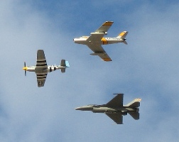
The airport closed at 3 PM and the Air Boss took over. A bunch of the performers took turns practicing their routines. It was mostly aerobatic stuff. The kind of flying that makes you wonder why people think helicopter pilots are crazy. These guys, purposely inverting their aircraft and letting it go out of control in tumbling dives are the ones who are crazy. But it was pretty cool to watch, as long as you didn’t try to think yourself into the cockpit. There was also a bunch of tight formation flying, including a flight with the F-16 and two other fighters: the Heritage Flight. (Not a bad shot with my new camera, huh?)

The gates opened to the public at 4 PM.

I did two flights that afternoon with 2 passengers each. The route was about 12 miles round trip. I’d take off from the ramp and follow the power lines between the Glendale and Luke airspaces. Then I’d either go northwest along Grand Avenue to Bell Road or continue north toward Sun City (which is laid out in a bunch of circles that look pretty cool from the air). Then I’d loop around to the right or left and come back pretty much the same way I’d left. The ride ranged from 8 to 12 minutes. GC helicopters was selling them for $45 per person, which I thought was a little high. (I was eventually proved wrong.)

We did rides while the air show was going on. Since we never crossed into the performance area, there was no danger. It was really weird to see a performer’s smoke trail on the return flight to the airport. We also did rides during the brief period when they reopened the airport to regular traffic. One time, on the second day, the Spitfire, which had to make a right traffic pattern during performances, flew over us. My passengers loved it. Late that afternoon, the GC guys brought their R22 over and I think they did a bunch of rides, too.

Balloon GlowThen the sun set and the balloon pilots started setting up for the big evening event: the desert glow. By 6:30, 19 balloons were floating right over the taxiway, using their burners to light up the night. The ramp was open to the public and thousands of people were wandering around right beneath the massive envelopes. It was magic.

I flew home in the dark, disappointed by the amount of work I’d done. Four passengers was not enough to even cover my transportation costs.

The next day — Saturday, October 29 — was distinctly different. Mike and I blew out of Wickenburg at 5:30 AM to arrive at the airport by 6 AM. It was dark in Wickenburg — especially dark since a power outage had affected the airport and none of the lights there worked. But I took off into the dark and soon saw the glow of Phoenix ahead. At 6 AM, I was three miles outside of Glendale. I made a radio call, which was answered by airport management. They told me the airport was closed. I told them I was part of the show. They told me to use caution when I landed.

I set down between the R22 and 2 F-16s again. The rent-a-cop the Air Force had hired to watch their birds overnight was standing exactly where he’d been the night before.

The balloons were already inflating for their morning flights. This was when the balloon owners actually made money — they sold hour-long rides as part of the show. Mike and I had taken a balloon ride back in New Jersey at an event like this years ago. It was expensive but something everyone should experience at least once.

Balloon ClassicI started flying at 7 AM, when the balloons were just lifting off. They drifted to the west-northwest, toward Luke Air Force Base. My pattern was a bit more north, so although I flew between a few of them, most of them were to my south. The view on the return part of our loop was incredible — dozens of balloons hanging in the early morning sky.

I flew on and off throughout the morning. The R22 did, too. Then somewhere around the middle of the day, things got busy. I flew nonstop for several hours, taking a break for fuel and another break when the F-16s flew. (For some reason, they didn’t want us in the air while the F-16 were flying.) Just after sunset, after finishing my last ride for the day, I consulted the tiny notebook where I’d been ticking off the passengers. 84 passengers. Wow.

I had a little excitement just after that last ride. The show had included a pair of rocket powered cars that sped down the runway, drag-strip style. I was still in the helicopter, listening to the radio, when someone told the Air Boss that one of the rocket cars had gone off the runway. The Air Boss acknowledged his words, but said nothing else. The other guy came back and said, “Well, can’t you send someone down there to make sure he’s alright?”

“I have no one to send,” the Air Boss replied.

“Ride-Hopper-One is spinning with no passengers,” I said. “Do you want me to go down and take a look?”

“Could you do that?” the Air Boss replied.

“Will do.”

I took off and sped down the taxiway while thousands of spectators watched me. It was dark and my navigation lights and landing lights were on. I probably looked like a blur of lights to them. I got down to the end of the runway around the same time as a pickup truck. The rocket car was pointed on an angle to the extended centerline, about 100 feet past the end of the runway. It was upright. Someone who looked like he could have been the driver was walking around. I reported all this to the Air Boss, along with the information that the pickup truck was there to help.

“We’re sending a fire truck down there,” the Air Boss said over the radio.

I started back along the runway. “The car is upright and there’s no smoke or flames,” I added.

I came back to my parking space on the ramp, set down, and shut down.

Mike and I watched the balloon glow together, walking among the balloons. It was still going on when we climbed back into Zero-Mike-Lima and went home. The next day, we arrived at the airport at 7 AM. Some of the balloons were already lifting off. The day got off to a slow start for us. But by 11 AM, we were cranking. I flew nonstop for several hours, then sent in the word that I was getting seriously tired and that they should stop selling tickets. By the time I finished at about 2 PM, I’d flown another 43 passengers.

I should say here that two things really amazed me. One was that folks thought nothing of spending $45 per person to take every member of the family for a ride. Mike thinks at least a dozen of the people I flew were kids under the age of 5. How many of those kids will remember the ride? A bunch of them were really excited and happy. One little red-headed boy had a smile bigger than the Cheshire Cat’s. I’m so accustomed to people balking at $30 or $32 per person for a flight that the idea of them lining up to spend $45 on multiple family members really surprised me.

The other thing that amazed me is how good kids are at buckling their seat belts. I don’t have kids and never had. I don’t spend much time at all with kids. But every once in a while, Mike would sit a kid in the front seat beside me for a flight. I’d tell him (they were mostly boys) to reach over and get his seat belt. He’d immediately locate the buckle (not just the strap), adjust it in the strap, and fasten it. Kids did this better than adults! I even watched one sharp 6-year-old untwist the belt before buckling it. Mike says it’s because kids that age are geniuses. They absorb everything they’re taught. I wish they could stay that way.

We managed to escape from Glendale right before one of the F-16s fired up for its part of the show. I called the Air Boss as I hovered into position for departure. “Ride-Hopper-One departing to the northwest.”

“Ride-Hopper-One, proceed as requested. This will probably be your last flight until the F-16 lands.”

“This is my last flight for the day,” I told him. “I’m going home. You guys have been great. Thanks.”

“My pleasure,” the Air Boss replied.

On my way back to Wickenburg, I pointed out the small herd of bison I’d spotted in a pasture less than a mile from Glendale Airport.