But which one?
I put off writing about this photo because I wasn’t sure exactly where I snapped it. I know it’s in Maine and I know I took in in October, when Mike and I went to spend a week with John and Lorna at their place in Winterport. I wrote about the trip in my old blog, but it hasn’t made it to this blog yet. (I still have about 60 entries to import; I did about 12 yesterday.)
 There’s no place in the world that looks as much like New England as some of these New England coastal towns. It’s the harbors, I think, filled with all kinds of boats, and the typical New England style architecture all around. And the colors, too.
I took this photo late in the afternoon from a park overlooking the harbor. We’d just spent a while walking around the town, browsing shops. It had been a foggy morning — every morning was foggy while we were there — and if you have really sharp eyes, you can see the fog bank way out to sea in this photo. (It may be easier to see in the larger header version of this image, which should eventually rotate to the top of this page if it isn’t already showing.)
I’m not sure what town this is. We did a lot of driving up and down the coast. It might be Searsport, Belfast (my vote), Camden, Rockport, or Rockland. (I admit that I’m looking at a map right now, trying to figure it out.) I’m hoping Lorna or Larry read this soon and use the comment link to tell us.
One more thing: there can’t be anyplace else in the country that’s more different from central Arizona than the coast of Maine. It was a great trip, refreshing to be back in a place where rain and fog were relatively common weather phenomena and where I could smell the salt air almost everywhere I went.
 One of the great things about digital cameras is that you can snap as many stupid pictures as you like. You can then just delete them all without any money or film or paper wasted. But once in a while, one of those stupid pictures is a keeper. That’s what I think about this photo I took while Mike was driving us across the Whitestone Bridge, from the Bronx to Queens, the day after Thanksgiving, 2005.
 We had a rim-view room that overlooked some of the most beautiful rock formations Sedona has to offer. We spent the late afternoon on the room’s back patio, sipping wine and watching the setting sun change the shadows on formations like the Coffee Pot shown here.
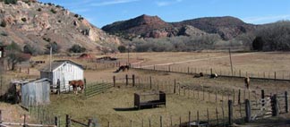 The ride ends at Perkinsville, where the canyon opens up to a broader valley. There’s a ranch there and the train stops literally in front of the ranch house. The place appeared occupied — there were horses and cattle there — but there wasn’t a person in sight. The conductor guy told us the story. Years and years ago, when the railroad was built, the land at the ranch was needed as a station to take on water and fuel for the steam engines. The railroad had offered the land owners a lump sum or a royalty for the use of the land. The Perkins family had taken the lump sum, giving up their control of the right of way. Today, under new ownership, the tour train had control of the land. The people who live in the house make themselves scarce when the train stops there on every run.
 Why does the train stop at all? Well, this is the place the engines are moved from the front of the train to the back for the return ride. There’s a siding there and while we’re waiting, enjoying the scenery and feeling kind of bad for the people who have to deal with 130 tourists a day looking into their windows, the engineer takes the two engines and moves them. The task takes about 20 minutes and they sell ice cream sandwiches to us while we wait. Then we’re on our way back to Clarkdale at a slightly faster speed, leaving Perkinsville behind.
 The very first image I created for this site’s rotating headers — in fact, the only image that appeared before I even installed and activated the rotating header feature — is this shot taken from our vacation property at Howard Mesa.