Something I’d prefer not to repeat any time soon.
If you follow me on Twitter or read this blog regularly, you know that I spent last weekend in Las Vegas doing a multi-day charter flight for two women from Prescott. The job was to fly them by helicopter to Vegas, where they’d spend two nights as part of a family get-together, and then take them home on Sunday afternoon. It was just the kind of gig a pilot looks forward to: an all expense paid weekend in Las Vegas. As an added bonus: the weather would be perfect.
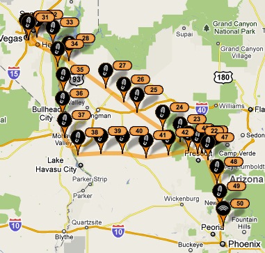
I picked them up at Prescott Airport (PRC) on Friday afternoon. My passengers were great people, although they seem to have packed enough luggage for two weeks instead of two days. (Honestly, how many changes of clothes does a person need in less than 48 hours?) I took off from Prescott at about 3:15 PM and made a beeline for the Hoover Dam 140 nautical miles away. My goal was to be on the ground in Las Vegas before dark.
Strike 1: Fuel Pump Failure
We were about 60 NM short of the dam, not far from Hackberry, AZ on old Route 66, when the Aux Fuel warning light illuminated. I remember thinking to myself: Oh no, not again. I checked the circuit breaker for the pump and sure enough, it had popped out. I pushed it back in. It popped right back out. So there I was, in the middle of nowhere, with an auxiliary fuel pump failure.
As I’ve written elsewhere in this blog, the auxiliary fuel pump is a redundant piece of equipment on a Robinson R44 helicopter. Although it’s required for operation on launch — in other words, I can’t legally take off if it isn’t working — it doesn’t do anything in flight except wait around for the engine-driven fuel pump to fail. Fortunately, that fuel pump is apparently much better designed and built because it doesn’t seem to fail at all. This particular auxiliary fuel pump was the third one that had failed on my helicopter since it was new 5 years (about 1100 hours) before.
As a pilot, I had a decision to make. I could:

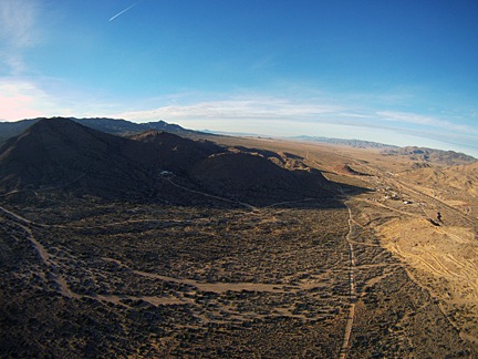
We were right about here when the auxiliary fuel pump failed. That group of buildings on the right is Hackberry.
Land there in the middle of nowhere where it would be extremely difficult to get help. Not only would this ruin my passengers’ weekend by delaying them at least 5 hours, but it would be extremely costly for me to get them (and me) transportation anywhere else. This was something I considered for only a moment. The helicopter was running fine and the emergency procedure says land as soon as practical. Hackberry, AZ was not a practical place to land.
- Detour to Kingman. Kingman, AZ was about 12 NM southwest. It was marginally better than Hackberry and the same arguments against it apply. But given a choice between Hackberry or Kingman, I would have gone to Kingman.
- Return to base. The Robinson guy I spoke to yesterday said that on an auxiliary fuel pump failure I should go back to base, but since I was much closer to my destination than base (Deer Valley Airport in Phoenix), going back to base seemed pretty silly. Frankly, I didn’t even consider it.
- Continue the flight to Las Vegas. This seemed to make the most sense. Again, the helicopter was flying fine. There were several small communities and one or two small airports along the way. If I started experiencing any problems, I could set down there.
I chose the last option.
Again, everything was running smoothly so I wasn’t really worried. Just a little more alert than usual, listening hard for an engine hiccup that might indicate a fuel flow problem.
Problem-Solving
As we flew, the back of my mind worked on the problem I now had to deal with: getting the pump replaced before 1 PM on Sunday. It was actually a two-part problem:
- Getting a fuel pump. The last time the pump had failed, I’d tried unsuccessfully to find a replacement locally. The Robinson Helicopter Company had them in stock, but they’d shortly be closed for the weekend and I’d missed their shipping window anyway.
- Finding a mechanic to install the fuel pump. The last time I’d had mechanical problems in Las Vegas, Silver State Helicopters had still been in business there. Their mechanic had come to McCarren and made a ramp repair. But Silver State was gone and I had no connections in Vegas for repairs. Especially on a weekend.
Understand that if I didn’t get it fixed by midday Sunday, I’d have to:
- Provide alternative transportation for my clients back to Prescott. That meant two plane tickets from Las Vegas to Phoenix followed by a 160-mile round trip car service ride.
- Refund at least part of the money my clients had paid me to fly them up to Vegas or provide them with a 2-hour flight somewhere else in the future.
- Spend additional time in Las Vegas, incurring more costs while I remained unproductive.
That would cost more than a repair — and I’d still need the repair.
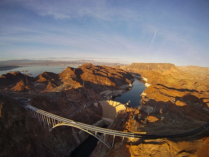
One of my favorite photos from our Prescott to Las Vegas flight on Friday.
The answer came to me not long after crossing over the Hoover Dam and its new bridge. My Seattle mechanic had made a “hangar call” in Phoenix for another one of his customers in October. Maybe he’d come to Vegas. And since he had a bunch of R44s, if he didn’t have the pump on a shelf, he could pull one out of a helicopter temporarily as a loaner. It seemed like a good bet. After all, who would turn down a free trip to Vegas?
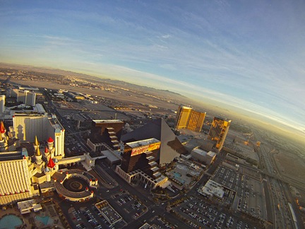
Only in Las Vegas can a pilot fly between a glass pyramid and a garishly painted medieval castle.
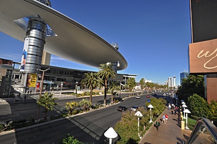
My route took us up the west shore of Lake Mead to Lake Las Vegas, then west into the sinking sun toward the Stratosphere. We crossed over the Strip as tourists in the tower beside us took photos of us, then headed south along I-15 on the west side of the Strip. I turned base leg between Luxor’s pyramid and Excalibur’s medieval castle, then came in for landing on the Atlantic Aviation ramp on the northwest corner of McCarren Airport (LAS).
While my passengers visited the ladies room in the FBO, I was on the phone with Rich, my mechanic. Within 10 minutes, we had a solution. He’d fly to Vegas that weekend and replace the pump.
While this seems like a happy ending, it would also be an expensive one. I’d have to cover Rich’s round trip airfare to Vegas — with tickets bought at the last minute — and pay a weekend labor rate about three times his normal rate that would also apply to the four hours of travel time. And the pump would cost another $1,600. Plus, in order to facilitate transportation for Rich and any needs he might have, I rented a car at the FBO for $85/day. My free trip to Vegas had suddenly become very expensive.
Strike 2: Rio “All Suites” Hotel
My reservations were at the Rio, an off-the-strip hotel that markets itself as having all suites. I wanted to be comfortable for my stay, so I’d looked into it. Vegas is hurting in this economy and deals are everywhere. I got an upgraded “Strip-view suite” for $80/night.
They put me on the 23rd floor of the tower. I looked out the window, expecting to see the Strip. I didn’t. I called the desk. After speaking with three different people, they agreed that my room was not Strip-view. Since I’d paid for Strip view, they moved me to a room on the 26th floor. They’d send a bellman up with my new keys.

The view from my room around sunset. Okay, so it doesn’t suck, but it isn’t what I expected, either.
I waited 30 minutes for the bellman. When I got to my new room, I found that it was on the same side of the hotel. But because the hotel was curved, it had a partial view of the Strip. That’s the best they were willing to do.
As far as the “suite” part of the room’s description goes, the folks at the Rio obviously have a different idea of what a suite is. To me, a suite is either two rooms or one room with a divider between living and sleeping areas. Embassy Suites has suites. What I had at the Rio was a big room with a bed, sofa, desk, and TV that faced neither the bed nor the sofa. It was not, by any stretch of my imagination, a suite.
There was nothing very appealing about the room at all. It was rather run down, although the bed was comfortable and there were plenty of pillows. The business part of the bathroom — shower and toilet — was small, although the outer area was quite large. The climate control system clanked every time it kicked on, so I left it turned off at night so I could sleep.
I won’t be staying at the Rio again and I don’t recommend it to anyone.
My advice to anyone who wants a nice room in Las Vegas: stay in a hotel less than 5 years old — there are plenty to choose from — on the Strip.
Strike 3: Buffet Dinner
I was meeting friends who were in Vegas for National Finals Rodeo (NFR), which was finishing up on Saturday. I’d invited them to join me for dinner. To compromise on our food choices, I picked the Rio’s buffet, which I’d heard was very good.
As usual with Las Vegas and so many American things, quantity seems more valued than quality. Yes, the buffet had over 300 items to choose from. But none of them were outstanding. In fact, unless you like to stuff yourself with mediocre food — which I don’t — it was a huge disappointment.
But they did have a good bread pudding for desert, and my friends seemed happy enough. Still, I won’t be eating there again.
Hit 1: Sleep
I slept remarkably well. Although the room was right next to the elevators and vending area, it was quiet. There was a bit of noise when my next door neighbors came in — the room had a connecting door — but they got quiet pretty quickly. And, thankfully, I didn’t have to listen to them having sex.
I did wake for the day at 4 AM, but that was to be expected. I was on Arizona time, and I usually wake around 5 AM there. I got a blog post written and posted using Bluetooth tethering on my BlackBerry to access the Internet, then showered and started my day.
Hit 2: Walking/Shopping Las Vegas
I am not a gambler. I don’t see the point. To me, the people parked on stools in front of slot machines like zombies are missing out on the finer points of life. The people at gaming tables are at least getting some social interaction — but at what cost?
Las Vegas is one of the freakishly weird places on earth and there’s nothing more interesting to me than to explore it on foot.
So after visiting my friends at the Cowboy Christmas market they were participating in at the Hilton’s convention center, I headed over to the Las Vegas Fashion Mall on the Strip. I got a great parking spot under the mall and went up on a mission: Buy a Verizon MiFi.
You see, back when I bought my iPad, I made a conscious decision to go with the WiFi only version. I was already paying for Internet three ways and couldn’t see adding a fourth. Besides — silly me — I thought Apple might enable Bluetooth tethering, like I could use with my MacBook Pro and Verizon BlackBerry Storm.
Two things happened:

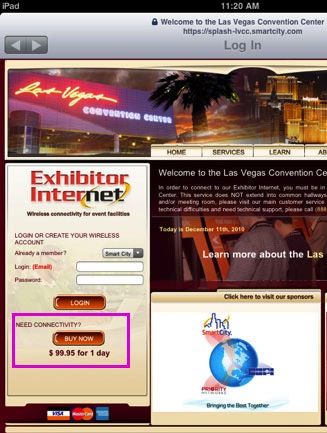
Yes, the Las Vegas Convention Center wanted $99 a day to access their WiFi.
I started traveling with my iPad only. Without my MacBook Pro, I couldn’t set up an Airport Network to share my Internet connection with my iPad. If WiFi wasn’t available, I couldn’t use Internet features on my iPad. And I was certainly not going to spend $9 to $99 a day to access the Internet at a hotel without free WiFi. (I’m addicted, but not that badly.)
- I began using Square. Square is this great system for accepting payment by credit card. It requires an iOS or Android device. I use it on my iPad. Problem: it requires Internet access. No WiFi, no chargie.
I’m due for a new phone after December 23. I’d already decided to buy an Android phone — probably the Motorola Droid 2 — so it would work with Square. I’d done extensive price calculations to see which would be better: using the phone as a hotspot (it has that capability) or getting a MiFi. The cost was about equal, but having the MiFi would give me greater flexibility in that I’d get more bandwidth for less money and the additional bandwidth cost was cheaper. Plus, as I later learned, I’d be able to continue using the Internet while I was on the phone.

Smaller than a pack of cards, this MiFi will connect me to the Internet just about anywhere I go.
Verizon has a special deal on the MiFi 2200 right now. The device is free with a 2 year plan. I decided to go for it and that’s why I went to the mall.
I found a Verizon kiosk, picked the brains of the very knowledgable and friendly but not pushy sales guy, and signed up. I walked out with a MiFi, stowed it in the car, and went out the mall’s main entrance on foot to explore that area of the strip.
The front of the Fashion Mall from the overpass at the Wynn across the street.
I crossed over to Wynn, where I had lunch in Red 8, a Chinese restaurant. I’ve been really hungry for good Chinese food lately — there isn’t any in Arizona — and had a bunch of it in Las Vegas.
Yes, this is completely indoors. Why have a real sky when you can have a prettier fake one?
From there, I walked down the strip past the new (to me) Palazzo and into the Venetian’s indoor shopping mall. The Venetian was built in the tail end of the wacky phase that demanded rides in every hotel and, because of this, it has an indoor “canal” with gondola rides. I bought a very unsatisfactory tiramisu in a “bakery” and wandered back out onto the strip.
I got about as far as Harrah’s when I started feeling hot and tired and figured it was time to head back. So I crossed the street and walked along the strip past the Mirage and Treasure Island. They were doing work on the sidewalk there and they detoured all traffic into the casino (how convenient), but I found the walkway over the road to the mall. I wandered up to the Apple Store to see what kind of iPad cases they have — I’m actually looking for a purse-like case — and then wandered out empty-handed. Three hours after I’d started my walk, I was back in my rental car, exhausted.
Hit 3: Dinner at the Burger Bar
During my walk, I’d decided to cheer myself up from my helicopter maintenance woes by going to a show. I’d heard a lot about Chris Angel as the big up-and-coming magician. He had a show at the Luxor that was somehow connected to Circue du Soleil. I called and, as a party of one, got a third-row seat to see the 7:00 PM show.
So after taking a nap and configuring my new MiFi, I headed out to the Luxor to pick up my tickets and grab a bite to eat before the show. I wound up in the Burger Bar, which is on the overpass between Luxor and Mandalay Bay. I’ve eaten there before. It’s basically a pricey burger joint, but it’s easy and there’s aways a seat at the bar.
I wound up sitting beside a woman in her early 30s who was also alone. Only moments after I arrived, she struck up a conversation. Within minutes, we were chatting like old friends. She was from a small border town in Canada and was on exactly the same page as I was regarding politics and the role of religion in society. She was an outdoorsy person who was out of place in the zaniness of Las Vegas, but was determined to explore it. She’d read about the Burger Bar in a tour book and had asked her friends to join her there for dinner. But they’d rather shop so she’d hopped on a bus from Planet Hollywood (up the strip) and had made the trek alone.
It’s always interesting to me to see how people from other countries similar to the United States think of us. At one point, we were discussing the tax situation in the United States and she said, “I can’t believe you people want tax cuts when you have such a huge deficit and you don’t even have universal healthcare yet.”
I consider that meal a high point of my weekend. It wasn’t the food — I had the sliders and they were pretty good but nothing special — it was the conversation. It’s always great to meet someone who has the same basic ideas you have. Just when I think I must be nuts because of what everyone else is thinking and doing, I meet someone who thinks the same way I do. It confirms that I’m not nuts after all.
Strike 4: Chris Angel Believe
I’ll start by saying this: Do not waste your money on this show.

Interesting that the letters LIE should be bold in the logo. The show’s description was certainly a lie.
Chris Angel has built a show to stroke his ego and feed his narcissism. A big video screen shows photos and videos of Chris in action throughout his life at various points in the show. (Apparently, I’d come to watch TV.) His comedic sidekicks shared immature bathroom joke humor that served primarily to get cheap laughs and stretch out the show’s length to 90 minutes.
Every once in a while, Chris would do a magic trick. Most tricks were some version of the transposition illusion, where Chris and an assistant or sidekick exchange places using a teleportation illusion. I think he did at least five of these and, after the third one, I felt like saying, Okay, I get it. You can switch places with someone. Let’s move on.
He also escaped from a straight jacket while hanging upside down — a trick my cousin was doing when he was in his teens.
He apparently swallowed razor blades and string and pulled the string out with the razor blades tied to it. Teller of Penn and Teller does the same trick with sewing needles and is a lot more entertaining as he does it.
He put on a big, bulky stage coat and then proceeded to produce birds. (Gee, where did they come from?)
He cut an assistant in half in a relatively gory version of the usual trick.
He defied gravity, but in each instance, it was pretty easy to see an assistant releasing the invisible wires attached to his back. In fact, I’m not even sure if we were supposed to be impressed by that; it was pretty transparent.
There were other tricks, too, but not enough to fill 90 minutes — hence the chatty fill and stupid jokes. Every break in the action seemed to be an opportunity for Chris Angel to brag about himself or promote his TV show or products for sale in the gift shop. It was probably this aspect of the show that turned me off so much. I think that if he’d had a more likable personality and wasn’t so damn full of himself, I could be more forgiving of his performance. But to brag about how great you are and then deliver such a mediocre performance was unforgivable.
When the show ended, it did so abruptly, leaving the audience wondering if it was really over.
I cannot believe how much money I spent on this show and how absolutely ripped off I felt when it was done. I would have better spent the same amount of money feeding into slot machines. At least I would have seen something different at every spin.
Oddly enough, my passengers saw the next show that night — the 1,000th performance. They were equally disappointed. I’m really surprised that this show was so well attended. In my opinion, it sucked.
Strike 5: Stomach Problems
Despite the fact that two doctors have told me that there’s nothing seriously wrong with my stomach, I was up in the middle of the night with severe acid reflux and nausea. I had no medicine — not even Tums or Rolaids — to take. I prepared the bathroom for the expected second act where I’d lose those tasty sliders and fries, then went back to bed. Propping myself up on all the pillows so I was nearly sitting up really helped. I was even able to get back to sleep without losing my dinner.
From now on, I travel with Tums.
Hit 4: Rich to the Rescue
Parked on the ramp at LAS. The 747 behind me is a private jet belonging to the owner of the Venetian.
My mechanic, Rich, arrived at LAS on time at 8:20 AM on Sunday with a remarkably small duffle bag. I picked him up at the main terminal and drove him over to the Atlantic Aviation terminal. The drove us out to the far reaches of the ramp, where they’d had me parked. Rich got right to work. Within minutes, the side panel was off and he was pulling the old pump. Once the new pump was in, we ran it to check for leaks. Then I ran up the helicopter while he slid underneath to make sure everything was okay.
By 9:30 AM, we were walking back to the terminal. He decided to try to catch an earlier flight back, so I drove him around to the main terminal and let him off. Mission accomplished.
I’ll get the bill in the mail.
Strike 6: The $8.54 Smoothie
I had 3 hours to kill before departure time. I decided to kill it at Mandalay Bay, which has a bunch of really great restaurants. It was too early for lunch, so I figured I’d pick up a smoothie, which would help keep my stomach settled. All I’d had to eat that day was a cup of green tea and half a toasted bagel with cream cheese.
There was a yogurt place on the north side of the casino that had make-your-own smoothies. You’d fill up a cup with your choice of frozen yogurt flavors and some fresh fruit, then hand it off to the girl behind the counter. She’d toss it in a blender with some 2% milk.
It wasn’t until after my mix was in the blender that I was told it would cost $8.54. Ouch. Well, at least it was tasty.
Hit 5: Lunch at the Noodle Shop
I went for Chinese food for lunch again. This time, I had congee, which is a Chinese rice gruel. It sounds gross and most American folks probably would think it is. But I like it.
Back in the 1980s, when I worked for the City of New York, my partner was Chinese, originally from Hong Kong. On payday, after picking up our checks at the our office in the Municipal Building, we’d head over to Chinatown for lunch. She’d take me to the restaurants where the Chinese people ate. I’d be the only Caucasian in the place. She’d order in Chinese and I’d eat whatever she ordered for me. I think that at first she was trying to see what I’d eat. She soon learned that I’d eat anything. Congee at Big Wong was one of our favorites; she’d order it with tripe sometimes or with little meatballs made of god-knows-what.
At the Noodle Shop in Mandalay Bay, I had congee with abalone and chicken. I’d never had abalone before and I figured it was worth a try. It was good, but not worth the extra money. I would have been just as happy with pork. But at least I know what abalone is like now.
Return Flight
I got back to the helicopter at 12:30 PM and preflighted it. I settled my bill at the Atlantic desk for fuel, parking, and “security” fee. I then went into the pilot lounge to wait for my passengers. They had WiFi there and I spent some time Tweeting and Facebooking. My passengers showed up right on time at 1:30 PM and we got a lift out to the helicopter.
Bummer. They made me fly up the west side of I-15 instead of up the Strip.
On departure, I asked to fly up the Strip but was told I couldn’t. I have a feeling security concerns have made that off-limits to pilots now. (I was able to do it about two years ago for my husband and his mom.) Instead, I was allowed to fly up the west side of I-15 as two tour helicopters came down the east side. Disappointing, mostly because I couldn’t give my passengers the Strip tour I’d hoped to — and I couldn’t get the incredible pictures I’d expected to get from the helicopter’s nose cam.
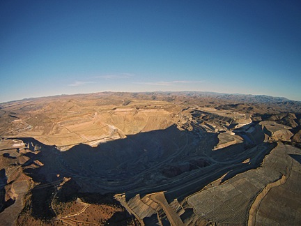
The relatively small open pit copper mine at Bagdad, AZ.
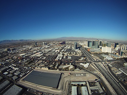
After retracing my route back to Hoover Dam, we followed the Colorado River south, past Lake Mohave, Laughlin, and Topock Gorge. At the north end of Havasu City, I turned east and beelined it for Bagdad. We flew over the mine and could see Granite Mountain just northwest of Prescott in the distance. We set down at the FBO in Prescott at 4:45 PM local time. My passengers thanked me as I walked them into the FBO. We talked about other flights. Then they left.
After fueling up and visiting the ladies room, I climbed back on board and headed back to Phoenix. I landed about 15 minutes after sunset, exhausted and glad to be back.
I’m in no hurry to go back to Las Vegas.

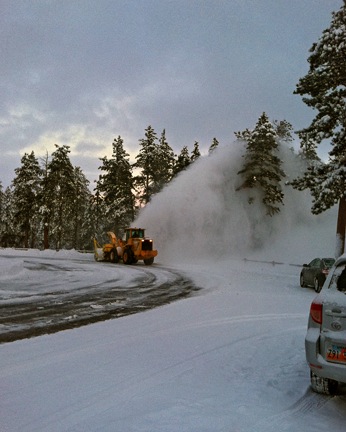 My client steered us to Sunset Point. Two very large snow throwers were at work in the parking area where only two cars were parked. We parked behind one of them, got our gear together, and headed out to the lookout point.
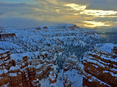 The first hint that things might improve came a while later when the sun started breaking through the clouds. I snapped this photo using the HDR function of my iPhone and then fixed it up a bit more in Photoshop to bring out the shadows. Not too impressive. The light faded again right after that and I started thinking about how warm the car might be. But I decided to stick it out a bit longer.
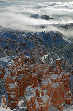 Snowy Bryce Dawn 1
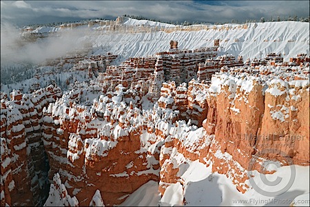 Snowy Bryce Dawn 2
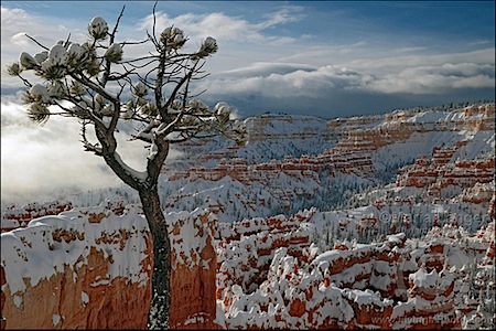 Bryce Canyon Lone Pine
 At 7:30, after getting no answer at the airport again, I got dressed in my best effort at winter gear. That meant a cotton turtleneck shirt with a cotton long sleeved shirt over that, a pair of nylon/spandex leggings with a pair of denim jeans over that, cotton socks, sneakers (I left from Phoenix where I don’t keep a pair of boots), my wool scarf, my leather jacket (with lamb fleece collar removed so as not to gather snow), ear warmer head band, baseball cap, and wooly gloves. The only pieces of clothing from my suitcase that I wasn’t wearing were my pajamas, the shirt I’d worn the day before, and one extra shirt I’d brought along. I looked ridiculous (see photo; I don’t think putting this photo on Craig’s List would get me in as much trouble as
  I had a plastic shopping bag with me and I used it to cover one arm. (The goal was to keep as dry as possible.) I then used sweeping motions to get the snow off the car. It didn’t take long. The snow was a bit wet but moved easily. Not very heavy. But there was at least 8 inches of it accumulated. What would that weigh on my blades? I was starting to get very nervous about it.
 In slow motion, the car skidded nose first into the snow bank on the right side of the road.
 I admit I wasn’t looking forward to the gig. The two photographers claimed to weigh 242 pounds (converted from kilos) and I knew they likely weighed more fully dressed and carrying camera equipment. I calculated the weight and balance as soon as I had this information and discovered that I’d have to strip all non-essential equipment out of the helicopter to lighten it up so we could take enough fuel for 2 hour flight segments (plus FAA-required reserves). Anything that was left on board would have to be shifted from under my seat to under the seat behind me, just to shift weight backwards. Having two fatties — yes, including me — up front would make us front-heavy. Having two fatties on the left side would make us heavy on that side. But even after adding 15 pounds of weight for each of them, I confirmed that’d be in balance with 2/3 fuel or less on board.
 Using
Using  What fascinated me was the way the light changed throughout the flight. At first, it was partly cloudy. Then the sun slipped behind the clouds and it was cloudy. Then the sun began to break through, speckling the mountainsides with light. This still image, captured from the video, gives you an idea of what I mean. The light changed numerous times over the two-hour period of the flight — at one point, clouding over completely only 1,000 feet above me — giving the illusion that the flight was conducted over multiple days.
 One of the highlights of the flight was crossing the red rock cliffs west of
  When I got to the empty expanse of the Navajo Reservation, I dropped down and flew low over the ground. There were few homes in the hundreds of square miles and only a handful showed signs of life. In the video, my helicopter’s shadow is clearly visible: small when I’m flying higher and larger when I’m flying lower. The video makes it seem as if I’m going much faster during this portion of the flight, but I’m not. I managed to keep a steady 100-110 ground speed for most of the flight. It’s just an illusion: the closer the camera is to the ground, the faster I seem to be flying.
 I’m working on an itinerary for a Flying M Air excursion client. They’ve decided to customize their Southwest Circle Helicopter Adventure to add another day at Page, AZ, as well as an overnight stay at Bullfrog Basin about halfway up Lake Powell.
 Over time, the water has carved a series of narrow slot canyons through the red rock sandstone. Two of these slots are open to the public. Upper Antelope Canyon is south of route 98 (see top satellite photo); Lower Antelope Canyon is north of route 98 (see bottom satellite photo). Examination of satellite images of the area show additional slot canyons along Antelope Creek, but they are not open to the public.
 Upper Antelope Canyon is, by far, the more visited of the two. I think there are two reasons for this:
 Lower Antelope Canyon has far fewer visitors than Upper. Unlike Upper, no tour companies — at least none to my knowledge — visit it. In addition, the canyon itself requires a decent amount of physical fitness. There are ladders, narrow passages, and various places where scrambling on the smooth sandstone is necessary. Heck, even the opening of the canyon, where you descend into a crack in the rock (shown here) seems designed to keep certain folks out: a fatty simply wouldn’t fit through it.
 The great thing about Lower Antelope Canyon, however, is that you have up to four hours to explore it pretty much on your own. This gives you plenty of time to shoot photos or lose yourself in thought between the smooth sandstone walls. Because there are far fewer visitors, it’s a more relaxed and pleasant place to visit. You can probably guess that I prefer it.