One of Sedona’s little secrets.
When we have out-of-town guests, we sometimes take them to the usual tourist spots in Arizona. (I can’t tell you how many times I’ve taken people to the South Rim of the Grand Canyon.) This past week, Mike’s mother has been in town. And over the weekend, we took her to Sedona for an overnight stay.
Sedona is a beautiful place. It has also become a bit of a tourist trap. “Uptown” Sedona is full off gift shops and counters for booking tours. Its sidewalks are roamed by people trying to get you to come see their timeshare opportunities. (I never could understand the attraction of timeshares.) If you’re looking for a t-shirt or a piece of Indian jewelry or some junky souvenir of red rock country, this is the place to come.
Uptown Sedona is right at the mouth of Oak Creek Canyon, a beautiful spot with a year-round creek, shady trees, and towering cliffs. A drive up through the canyon is the nicest way to reach Flagstaff, especially in the fall when the leaves on the trees along the creek are changing color.
So right before you reach the beauty of Oak Creek Canyon, you have to drive through the most touristy cluster of shops in Arizona. The same shops that block the views of some of the incredible red rocks that people have supposedly come to Sedona to see.
To be fair, Sedona’s local government has enacted certain zoning laws that require new construction to blend in with the environment. That’s why you’ll see a lot of reddish buildings. It’s also one of the few places I’ve seen dozens of homes painted a dark sage green–to match the scrubby desert pine trees that grow in the area. Unfortunately, those laws were not passed before Uptown Sedona was developed, so most of that area is pretty ugly.
We planned to spend the night in Sedona and needed a place to stay. We wanted to stay at a nice place–the last time we’d taken his mother on a trip in Arizona, we’d stayed at a weird place down near Tubac that had been built on top of an old missle silo. (I can’t make this stuff up.) Mike surfed the Web and came up with a place that included the word “Spa” in its name. The pictures looked good, but it was supposedly in West Sedona. I was worried that it would be too far away from the things his mom wanted to see–primarily shops–or tucked away in some back corner without any views. So I suggested a place where I knew there were good views: Sedona Sky Ranch.
Sedona Sky Ranch is Sedona’s airport motel. And that’s why so few people consider it as a place to stay. I consider it one of Sedona’s little secrets.
Sedona Airport is on a mesa just south of town. For those of you who didn’t pay attention during geology lessons in school, a mesa is a flat-topped mountain. There are a lot of them in Arizona and the rest of the southwest. Sedona’s airport sits on one of them. (The St. George, UT and Bagdad, AZ airports also sit on mesas.) It’s kind of neat because as you approach the runway in a plane, it’s a lot like landing on an aircraft carrier.
Sedona Sky Ranch is on the northwest side of the mesa, walking distance from the airport’s little terminal. It sits on the edge of the mesa and has about a dozen rooms that look right out over the town. And the red rocks beyond it.
 We’d reserved two Red Rock View rooms for the night. The rooms included 2 queen beds, a deck overlooking the views, and a kitchenette with a small fridge, microwave, and sink. And a bathroom, of course. Not what I’d call luxurious, but certainly very comfortable. And the views! At about 500 feet above the town, we didn’t have to look at any ugly commercial buildings. Sedona’s famous red rocks were right there. The photo here shows the view from our deck. The rock formation in the left center is called the Coffee Pot. (Think percolator.)
Mike and I shared a bottle of wine on the deck while the sun dropped down on the horizon, making the red rocks even redder. (Mike’s mom watched television in her room.) In the overlook parking area, which was a few hundred yards away, a native American musician played the drum and flute while tourists looked on. The sun set, the flute stopped abruptly, and the tourists got into their cars to go down to their hotels far below us. The full moon rose above the buttes in the east.
The next morning, when we checked out, we made reservations for October. We chose the cabin next door, which is slightly larger that our room, has a larger deck, and a slightly better view. We’ll drive up in the Jeep with Jack the Dog (they allow pets) and spend a few days exploring the back roads of the area while the autumn leaf show is in progress.
It’ll be a nice escape.
Oh, and that “spa” Mike found online? It was on the main road in West Sedona, right next to the Safeway shopping center. How’s that for atmosphere?
 There’s no place in the world that looks as much like New England as some of these New England coastal towns. It’s the harbors, I think, filled with all kinds of boats, and the typical New England style architecture all around. And the colors, too.
 One of the great things about digital cameras is that you can snap as many stupid pictures as you like. You can then just delete them all without any money or film or paper wasted. But once in a while, one of those stupid pictures is a keeper. That’s what I think about this photo I took while Mike was driving us across the Whitestone Bridge, from the Bronx to Queens, the day after Thanksgiving, 2005.
 We had a rim-view room that overlooked some of the most beautiful rock formations Sedona has to offer. We spent the late afternoon on the room’s back patio, sipping wine and watching the setting sun change the shadows on formations like the Coffee Pot shown here.
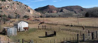 The ride ends at Perkinsville, where the canyon opens up to a broader valley. There’s a ranch there and the train stops literally in front of the ranch house. The place appeared occupied — there were horses and cattle there — but there wasn’t a person in sight. The conductor guy told us the story. Years and years ago, when the railroad was built, the land at the ranch was needed as a station to take on water and fuel for the steam engines. The railroad had offered the land owners a lump sum or a royalty for the use of the land. The Perkins family had taken the lump sum, giving up their control of the right of way. Today, under new ownership, the tour train had control of the land. The people who live in the house make themselves scarce when the train stops there on every run.
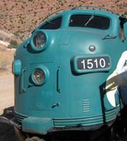 Why does the train stop at all? Well, this is the place the engines are moved from the front of the train to the back for the return ride. There’s a siding there and while we’re waiting, enjoying the scenery and feeling kind of bad for the people who have to deal with 130 tourists a day looking into their windows, the engineer takes the two engines and moves them. The task takes about 20 minutes and they sell ice cream sandwiches to us while we wait. Then we’re on our way back to Clarkdale at a slightly faster speed, leaving Perkinsville behind.
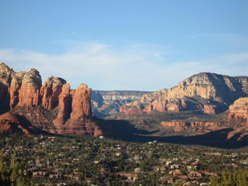 We’d reserved two Red Rock View rooms for the night. The rooms included 2 queen beds, a deck overlooking the views, and a kitchenette with a small fridge, microwave, and sink. And a bathroom, of course. Not what I’d call luxurious, but certainly very comfortable. And the views! At about 500 feet above the town, we didn’t have to look at any ugly commercial buildings. Sedona’s famous red rocks were right there. The photo here shows the view from our deck. The rock formation in the left center is called the Coffee Pot. (Think percolator.)