Just Say No to Traffic Patterns

Why waste time flying around the airport or hogging up the runway when you just want to get on the ground?

Note: A version of this post originally appeared in AOPA’s Hover Power blog. If you’re a helicopter pilot, you owe it to yourself to check in there regularly to read great articles written by experienced helicopter pilots.

Over the past nine or so years, I’ve done more than my fair share of long cross-country flights with newly minted commercial pilots or CFIs. In most cases, the purpose of the flight was to reposition my helicopter at a temporary base of operations 500 or more miles away and the typically 300-hour pilot on board with me was interested in building R44 time. I was on board as a passenger and got a chance to observe the things these pilots did — or didn’t do. I think the fact that I’ve never been a flight instructor gives me a unique perspective on what I observed.

One thing I’ve come to realize is that typical flight training does very little to prepare students for a commercial flying career. Instead, students are taught to perform maneuvers “by the book,” often so they can teach those maneuvers to their own students in the future. While it’s obviously important to know how to perform maneuvers properly, there are other concerns that are important to commercial pilots. In my upcoming posts for Hover Power, I’ll tackle a few of them, starting with traffic patterns.

I can tell lots of stories about new commercial pilots and CFIs entering traffic patterns to land for fuel at nontowered airports in the middle of nowhere. I can even tell you about the pilot who landed on the numbers of an empty airport’s runway, hover-taxied to the taxiway, and then hover-taxied a half mile down the taxiway to reach the midfield fuel island. They did this because that’s what they had been trained to do. That’s all they knew about landing at airports.

Our flight training teaches us a few things about airport operations, most of which are school-established routines at the handful of airports where we train. There’s a procedure for departing flight school helipads and there may be a procedure for traveling to a practice field nearby. Once there, it’s traffic patterns, over and over. Normal landing and takeoff, steep approach, maximum performance takeoff, run-on landing, quick stop, autorotation–all of these standard maneuvers are taught as part of a traffic pattern. It gets ingrained into our minds that any time we want to land at an airport, we need to enter a traffic pattern.

The reality is very different. Remember, FAR Part 91.129 (f)(2) states, “Avoid the flow of fixed-wing aircraft, if operating a helicopter.” Your flight school may have complied with this requirement by doing a modified traffic pattern at the airport, operating at a lower altitude than the typical airplane traffic pattern altitude of 1,000 feet, or landing on a taxiway rather than a runway. But despite any modifications, it’s still a traffic pattern.

But is a traffic pattern required for landing? No.

Experienced commercial pilots — and their savvier clients — know that traffic patterns waste time. And while the pilot might not be concerned about an extra few minutes to make a landing, the person paying for the flight will be. Why waste time flying around the airport before landing at it? Instead, fly directly to or near your destination and land there.

Before I go on, take a moment to consider why airplanes use traffic patterns. They enter on a 45-degree angle to the pattern to help them see other traffic already in the pattern. They then follow the same course as the other planes so there are no surprises. This is especially important at nontowered airports that don’t have controllers keeping an eye out for traffic conflicts.

But helicopters are avoiding this flow, normally by flying beneath the airplane TPA. As long as they stay away from areas where airplanes might be flying — remember, avoid the flow — they don’t need to worry much about airplane traffic. Instead, they need to look out for other helicopters and obstacles closer to the ground. If a runway crossing is required, special vigilance is needed to make sure an airplane (or helicopter) isn’t using the runway to take off or land. Obviously, communication is important, especially at a busy airport when a runway crossing is involved.

Now you might be thinking that this advice only applies to nontowered airports, where the pilot is free to do what he thinks is best for the flight. But this can also apply to towered airports.

Airport controllers who are accustomed to helicopter traffic and understand helicopter capabilities may instruct you to fly to and land at your destination on the field. You must be prepared to do this, even at an airport you’ve never been to before. That’s part of what your preflight planning is all about. Consult airport diagrams or even satellite images of the airport. Know where you’ll be flying from and where you need to park. Imagine the route to that spot. Be sure to take note of where the tower is–it’s often a great landmark for navigating while close to the ground. Never assume the controller will put you in a traffic pattern. And don’t be afraid to admit you’re unfamiliar if you didn’t do your homework or if things in real life look different from how they looked on paper or a computer screen.

What if a controller does instruct you to enter a traffic pattern and you don’t want to? As amazing as this might seem to new pilots, you can ask the controller to allow you to go direct to your airport destination.

PRC
The airport diagram for Prescott. The X marks the location of the restaurant and we were coming in from the west. Runways 21L and 21R were active. The tower instructed us to fly all the way around the south end of the airport, at least three miles out, to get into a pattern for Runway 21.

I’ll never forget the flight I had one day as a passenger on my friend Jim’s Hughes 500c. Jim was a retired airline pilot who had been flying helicopters for at least 10 years. We were flying into Prescott Airport (PRC) in Arizona for lunch. When Jim called the tower, he asked for landing at the restaurant. The controller told Jim to enter a traffic pattern that would have required him to fly all the way around the airport, taking him at least 10 minutes out of his way. “Negative,” Jim barked into his microphone. “One-Two-Three-Alpha-Bravo is a helicopter. We want to land direct at the restaurant.” A new pilot at the time, I was shocked by his tone of voice. There was an uncomfortable silence and then the controller came back on and told him he could fly direct to restaurant parking.

Will the tower always grant your request? It depends on the situation. If a runway crossing is involved and the airport is busy with traffic, they might not. It might be safer or more convenient for them to keep you in a pattern with the airplanes. But it can’t hurt to ask, although I don’t think I’d be as aggressive as Jim was that day.

One of the big challenges of becoming a commercial helicopter pilot is thinking like a commercial helicopter pilot. There are things we can do that seem to conflict with what we were taught. Landing at airports without the formality of a traffic pattern is one of them.

Golden Hour at the Aerie

Two shots showcasing my home.

Even amateur photographers — or at least serious amateur photographers like me — know that the best time for landscape photography is during the so-called “Golden Hour.” This is the time of day roughly one hour after sunrise and roughly one hour before sunset when the sun’s light is soft and often golden in color. Long shadows provide depth which adds texture and highlights contours in land forms. Colors are skewed reddish, which can make everything look just better.

Construction on my home has been mostly done — I still have a few things to do inside like finishing trim and building a set of stairs to the loft — for a few months now. I got my official certificate of occupancy about two months ago. I recently did some outside work to clean up “the yard” and make it look presentable. I have ten acres but I really only maintain about an acre of it — the rest is natural vegetation: bunch grass, sagebrush, and wildflowers. It gets really green here in spring but starts to brown up by late May. This year, we’ve had just enough rainfall to really turn on the wildflowers and keep the grass green and gold. Really pretty.

Perfect for capturing some shots of my home to share with friends and family.

I got the first shot the other day. I happened to be down at my Lookout Point bench late in the afternoon when I looked back up at my home. The light was just right to illuminate the multitude of wildflowers that had grown between the bench and my building. Unfortunately, I’d left my Jeep and truck in front of their garage doors and that made the place look less than perfect. By the time I moved them and came back, the light would be gone. I decided to do it another day.

Afternoon Home
I like this shot the best, mostly because you can also see the nearly full moon in the sky above the cliffs.

That day came a few days later. I was inside, resting up from some minor surgery I’d had earlier in the day when I realized that the light was perfect. I grabbed my phone and ran down the stairs with Penny at my heels. We hurried down the path to Lookout Point and I turned around. Perfect!

I shot about 10 photos from different angles. This is the one I like the best.

I very seldom share this view of my home. The reason: it only photographs well in the afternoon in late spring, summer or early autumn. Other times, the cliffs to the south are in shadows.

This shot really shows off the beauty of the cliffs behind my home. They rise about 1,000 feet above my road and consist of basalt columns of rock laid down during Washington’s prehistoric volcanic past and carved away by ice age floods. My home sits on a shelf of tightly packed silt; the land drops away again toward the river to the north.

The vegetation up there, by the way, is ponderosa pine with the occasional aspen grove. I’ll be planting some of those on my property in the years to come. The irrigation lines to get them started are already laid.

This morning, the light and clouds were perfect again for a golden hour shot of the front of my home, which faces east. I didn’t mind the truck being parked on the concrete apron by the big RV garage door — although the truck does manage to make the 14 feet tall by 20 feet wide door look small. I grabbed my phone again and hiked up my driveway and partially up the road behind my home. I took just three shots from different angles. This was the middle one and I like it best.

Morning at Home
This shot, taken this morning, shows off the front and north side of my home, as well as the view beyond. The view, privacy, and quiet is what sold me on this building site when I first saw it back in 2012.

Every time I look at my home, I realize that none of it would have been possible if I’d stayed married to the sad sack old man who was living in a rut in Arizona. I’m sad for him — he would have really liked it here, maybe as much as I do — but I’m thrilled to have had the freedom to build the home I wanted and to live the lifestyle I’ve come to cherish.

Life is what you make it. If you want something badly enough, you need to make it happen. There’s nothing that says that more to me than my home here at the Aerie.

Two Years Ago Today

A photo reminds me of a personal milestone.

Two years ago today, on May 19, 2014, the builders broke ground on the construction of the home I’d designed for myself on 10 acres of view property in Malaga, WA. I’d bought the land the summer before, the day after my divorce decree was [finally] handed down from the judge. The building would utilize post and beam construction, commonly known as a pole building, to give me a 2,880 square foot garage/shop area and 1,200 square feet of living space with a 600 square foot deck. The goal: all my possessions under one roof with a comfortable, modern home that would showcase the amazing view.

After doing some prep work — bringing in temporary power, putting in a septic system, finalizing plans with the builder, and getting the building site prepped for construction — the four-man team that did 90% of the building construction work arrived with equipment and started digging. They dug 44 post holes that first day and had the posts set in concrete by the end of the next day.

This photo, which I stumbled upon this past weekend while digging up photos for another blog post, shows the workers digging that first hole. The auger did most of the work, but they did hit rocks that had to be removed by hand. Miraculously, this was the only hole with large rocks in it.

First Hole
X marks the spots where the holes needed to be dug. They only hit rocks on the first hole. The trusses for the RV garage roof are leaned up against the hill in this shot.

I was living onsite at the time, in my RV parked near the building site. I had a GoPro camera set up on top of it and made daily time-lapse videos of the work, which I shared on my blog starting on May 20, 2013. It was an exciting time — I was watching something I’d designed be built right before my eyes. I kept out of the way but took lots of photos. In the evening, after the crew left, I’d wander around the site and play with the equipment, sometimes using it to move dirt or easily climb to the second floor once it had been built.

Now, two years later, I’m living in that home with a Certificate of Occupancy as the County’s approval for not only my design and Western Ranch’s construction, but the hours of labor it took to turn a metal building shell into a home.

When I look at these old pictures of the place before my building existed, I find it hard to believe that I’ve come so far in such a short period of time. It’s amazing how much I can get done when there’s nothing holding me back.

This photo — and the blog posts and videos and other photos that document the work done — marks a milestone in my life, proof that I can move forward and make things happen — better than ever on my own.

It’s hard to believe that this photo was shot only two years ago.

May Morel Mushrooms

I find and bag my first morel mushrooms.

Science Friday, an NPR radio show (also available as a podcast), did a show last Friday about mushroom hunting. It got me interested in mushrooms all over again.

Last October, I attended a weekend-long seminar at the North Cascades Environmental Learning Center about mushrooms. We learned about mushrooms, hunted for mushrooms, identified mushrooms, and ate mushrooms. It was a fun weekend.

About a week later, I went mushroom hunting in the Leavenworth area with one of the other seminar attendees. We didn’t do too well, but didn’t come back empty handed, either: two chanterelles, some oyster mushrooms, and something else I can’t remember. I took home the chanterelles; my companion took the rest. I returned to the area several times since then but haven’t had any success.

I’d pretty much given up on doing any serious mushroom hunting.

And then Science Friday did their story, “Mushrooms: On the Hunt for Edibles.” And I started thinking about foraging for mushrooms all over again. After all, it was the right season for them and I knew places where the conditions might be right. So I emailed my hiking buddy Susan, who also has some mushroom foraging experience, and asked her if she was interested. Of course she was! We went out around 9 AM Monday morning.

We took the Jeep up into the mountains. That’s about as specific as I’ll get for the location. As any serious mushroom hunter will tell you, locations are never divulged. Morel mushroom hunting is serious business in Washington state; hordes of hunters cross the Cascades every weekend this time of year. Some are commercial hunters; Susan says morels are worth about $30/pound. Others are hobbyists like us who use a mushroom hunt as an excuse to get outdoors and walk around in the woods.

Although we were unable to take the Jeep as far as I’d hoped, we parked at a familiar parking area, grabbed our bags, and headed into the woods. Penny ran ahead. For the next three hours, we wandered around the underbrush on either side of trails or roads, looking for just the right environmental conditions.

Trouble was, I didn’t know the right environmental conditions. I’d never hunted for morels. The only thing I’d every heard was that they grew in areas damaged by forest fires. The Science Friday story said they grew under oak and apple trees, but we don’t have oak trees here and there aren’t any apple trees other than in orchards.

After wandering around the woods off to one side of the road, Susan climbed back down to the road. “I think there’s an easier way down over here,” she called back from up ahead.

Morel Mushrooms
From my first find. Aren’t they gorgeous?

Morel Mushrooms
Can you see all five mushrooms here? Hint: two of them are together.

Morel Mushroom
Here’s a closeup of one of the last morels I found. As you might imagine, from a distance, pinecones look similar.

I made my way through the underbrush. I was about halfway down the steep slope when I looked down and saw it: a very large morel mushroom. Within seconds, I’d seen three more.

They were beautiful — I mean, really beautiful. Perfectly shaped, popping up through the dirt looking clean and brown and exactly the way a morel should. I took photos. I marked GPS coordinates on my phone. And then I cut them and put them into my canvas bag.

Susan found the next batch not far away and packed them away in a paper bag she’d brought for the purpose.

We talked about the conditions they were growing in. Plants growing nearby. Moistness. Amount of sunlight. We found things in common between the two patches. We began getting a real idea of what to look for.

We continued wandering around, on and off the road, for the next two hours. We took turns finding mushrooms. At one point, Susan found a huge one about three inches from my foot and I spotted a smaller one nearby. At another point, I found five of them within a square foot of space. Much later, the two of us, working within 15 feet of each other, found several patches of them.

Now I don’t want you to think that the mushrooms were all over the place. Well, mushrooms were all over the place — mostly shiny brown round ones — but the morels were elusive. One of us would find a patch and then twenty minutes might go by before the other found a patch. We were out there for three hours and we each brought back maybe enough for a meal. I weighed mine when I got home: 9 ounces.

It was fun and, because we weren’t getting skunked, it never got frustrating.

It was nearly 1 PM when we called it quits. We’d only walked a little more than a mile according to my GPS tracker.

I drove us back to Susan’s place and took a quick tour of her backyard rose bushes and gardens. We talked about the mushrooms we’d found and how we each planned to double-check that we’d found morels and not false morels, which were not recommended for consumption. Then I headed home.

Later, I laid out the mushrooms I’d brought home to take a photo. I also weighted them on my postal scale: 9 ounces even. Good thing we weren’t hunting mushrooms for a living.

Morel Mushrooms
Not bad for a first time out, eh?

Dinner tonight or tomorrow: Pizza with Ramps, Morels, and Eggs. I might also try one of the recipes I found for fried morels.

And since mushrooms grow so quickly, there’s a pretty good chance there will be more to pick later this week in the same places we found them today. I’m game for another outing on Friday. I hope Susan is, too.

Cross Country Flight: Sacramento to Seattle and Wenatchee

A look back at a memorable flight.

Since the winter/spring of 2013, my helicopter has spent two months each year in the Sacramento area of California on a frost control contract. I fly the helicopter down in late February and fly back in late April. I usually take along a fellow pilot who does most of the flying to build R44 time and shares the cost of the flight. Most of these people are relative strangers and although they’re usually nice guys or gals that I stay friends with after the flight, I admit that I prefer flying with people I already know pretty well. So this spring, when it came time to start thinking about that return flight, I started thinking about who I could invite to join me.

The answer hit me like a lightning bolt: of course I should invite my friend Don.

Don’s been a pilot for much of his life and has flown airplanes and helicopters. I don’t know how much time he’s logged, but I’m certain it’s more than my 3,300 hours. I also know he has tons of cross-country experience, including helicopter flights between the Seattle area and Alaska.

Why Don?

You might be wondering why I’d invite such an experienced pilot when there were so many low-time pilots who’d likely jump at the chance to fly with me on a six to eight hour cross-country flight. There are three reasons.

First, Don is a good friend I’ve known for years. He and his wife were very supportive during my crazy divorce, and you know what they say about a friend in need. He’s easy going and has a good sense of humor. I knew I’d enjoy spending time with him.

Don't Helicopter at PHX
Don’s helicopter on the T3 Helistop at Sky Harbor Airport in Phoenix in 2009. After I shared my experience approaching and landing at the helistop, he often picked up and dropped off visitors there. Later, in October 2012, he dropped me off there when I was off on one of my many trips.

Second, Don had owned a helicopter very much like mine — in fact, it was only six months newer — which he’d kept in his garage at his Seattle area home. About two years ago, he sold it. I knew he hadn’t flown much since and probably missed it. He would appreciate the flight; surprisingly, not everyone I’ve invited to fly with me on a long flight has.

Third, because Don already had so much flight time, he’d actually share the flight with me. After all, I like to fly. When I fly with other pilots, they’re paying for the privilege of every minute of stick time they can get. They don’t want to share the stick with me and I don’t feel comfortable asking them to.

So I texted Don to see if he was interested. The response came almost immediately. Hell, yes!

Getting to the Helicopter

Don has two homes, one in the Phoenix area and one in the Seattle area. He made arrangements to be in the Seattle area on the day we’d go south to fetch the helicopter.

I booked my flight from Wenatchee to Sacramento, which included a plane change in Seattle. Don booked his flight from Seattle to Sacramento on the same flight. Since Don always flies First Class, I bought a First Class ticket, too. When he booked his flight, he got the seat right next to mine.

We met at the gate for the Seattle to Sacramento flight. I’d been at the airport for two hours and had treated myself to a breakfast of trout and eggs at Anthony’s. Don had also been at the airport for a while and had breakfast.

I had Penny with me, of course. She’s always excited when she sees me take out her airline travel bag. She’d gotten back into the bag at the gate before Don arrived and he didn’t even realize I had her with me until we boarded.

There wasn’t supposed to be breakfast on our flight, but there was; a nice yogurt and granola bowl with fresh fruit that would have gone nicely with the Bloody Mary I couldn’t have. (First Class on Alaska Air really is worth the extra cost. Can’t say the same for all airlines.)

On the flight, we chatted, ate, read. Time passed quickly. We were on the ground by 10:45 AM. With no bags checked and a quick exit from the plane, we were at the curb waiting for our Uber driver by 11 AM. Penny seemed happy enough to be out of the bag, sniffing around someplace she was pretty familiar with. After all, we’d flown to Sacramento quite a few times over the past four years.

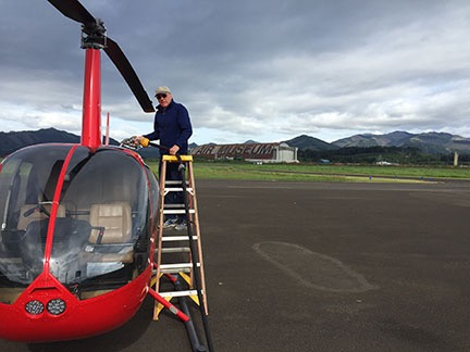
It was about a 30 minute ride to the airport where my helicopter had been parked on the grass for two months. I settled up my bill for parking and said goodbye to the staff there. Don preflighted and installed the dual controls while I folded up the cockpit cover and tie downs and went to work setting up my GoPro. That’s when I realized that I’d left the Mini SD card for the camera at home. Duh-oh! There would be no video from the flight.

California to Washington

We’d discussed our route briefly on the flight down. Neither of us was in a hurry and both of us leaned toward a flight up the coast, which would add about an hour to the flight time.

Marine Layer
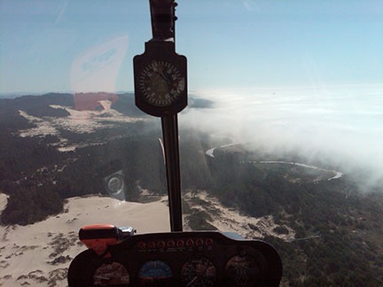
Here’s a shot of the marine layer on the coast of Oregon that forced us inland during a flight from Seattle to Wickenburg with my wasband in 2009.

My experience with flying the coast was varied. What I’d learned was that if I could get to the coast, I probably wouldn’t be able to follow it all the way up. The California and Oregon coasts are well known for their “marine layer” clouds. Although I’d flown the coast many times in the past, from Los Angeles to the Columbia River between Oregon and Washington, those damn clouds always made an appearance, forcing me inland so I’d never covered more than one or two hundred miles at a stretch. Last year, when I’d flown north by myself, planning on a coastal route, clouds with rain moved in not long after I hit the coast, forcing me inland for a dreary flight with more scud running than I like to do.

But nothing ventured, nothing gained, eh?

We followed Cache Creek west into the hills. I did the flying. I’d been wanting to fly Cache Creek all winter, but truck troubles had messed up my March plans and I wound up spending most of the month home instead of with the helicopter. I hadn’t flown nearly as much as I wanted to. This was my chance to get flying out of my system, flying a familiar and loved route. Somewhere in the hills, I turned the controls over to Don and he steered us over Clear Lake. Although the weather was clear where we were, there were clouds to the west (of course) and neither of us were sure whether they came into the coast or were off over the Pacific.

After flying up Highway 101 for a while, we decided to try heading west to see if we could make the coast. So we followed one of the canyons — I’m not sure, but I suspect it was the one the Noyo River flows in — concentrating on the path ahead of us. As expected, we were moving right in toward the clouds, which forced us lower and lower. But ahead of us, to the northwest, the sky was bright. Maybe it was clearing up?

We were flying about 300 feet over the road, stretching our necks to peer ahead of us and ready to turn around as the road went around a bend at a high point in the hills. We followed the bend and the road dropped away. We kept going.

Low clouds kept us flying low in the hillsides near Fort Bragg. We turned north, heading for our first fuel stop at Eureka. The coast was to our left and we occasionally caught glimpses of it as we flew over tree-covered hills with the clouds only a few hundred feet above us. I don’t think either of us wanted a trip up the coast in such conditions — I know I didn’t. But I also didn’t want to fly the I-5 corridor, which is painfully boring, especially once you get north of Eugene. We’d make a decision at Eureka.

The ceilings were much higher when we stopped for fuel at Eureka. We gassed up; Don bought the first tank. Then we went inside for a potty break. There wasn’t much else to do there — although the airport has a nice little pilot shop, there was no restaurant and nothing was within walking distance. So we climbed back on board and continued on our way, this time following the coast.

Cloudy Coast
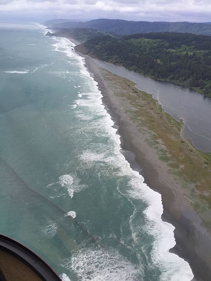
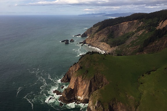
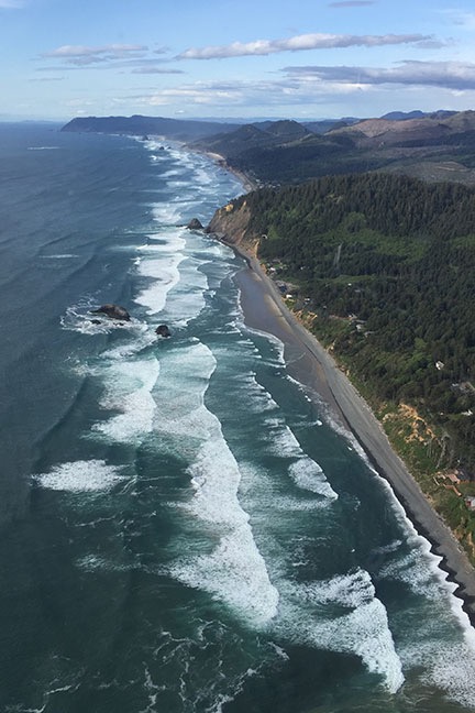
Despite the clouds, it was beautiful on the coast.

Brookings Bridge
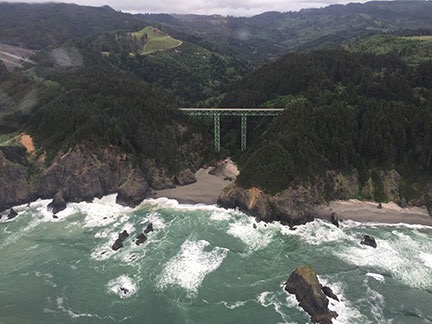
If you’ve driven on the Pacific Coast Highway — Route 101 — through Brookings, CA, you’ve driven over this bridge.

Near Newport
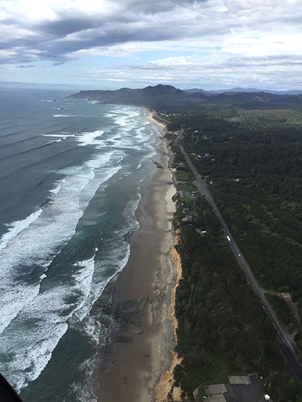
The coast near Newport, OR. I love the way the breakers line up when you see them at just the right angle.

Lincoln City, OR
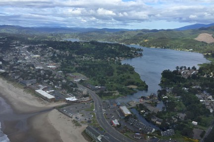
A look down into Lincoln City, OR.

By this time, the scenery around us was interesting enough to take some pictures while Don flew. The doors were on, of course, so most of my photos have reflections and glare and even window dirt. But they give you a feel for what the weather was like and show a little of how beautiful the California and Oregon coasts can be from about 500 to 1000 feet up.

The coast was very rugged at the beginning, where the Redwoods National and State Parks come right up to the rocky shoreline. There were no roads in many places — just trees right up to the cliffs with lots of small waterfalls dropping down into the ocean. This is a view few people see, a view that can only be seen from the air off the coast. Don steered us along its left, over the ocean, just within gliding distance of land.

In some places, we saw sea lions stretched out on rocky beaches. I took pictures, but they didn’t come out good enough to share.

The Pacific Coast Highway hit the coast and then went inland several times. Finally, just before we hit the Oregon state line, it came out to the coast and stayed there for quite a while.

The weather got a little worse at first, with light rain pelting the cockpit bubble in more than a few places, then started to get better. By the time we got into Oregon, we saw patches of blue sky. The sun was shifting ever lower toward the horizon to the west and the light started getting kind of good.

Good Light on the Coast
Light is 90% of photography.

Waterfall
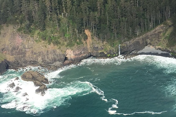
Waterfall near Otis, OR. Yes, I cropped this image; we weren’t that close.

Cloverdale
Cloverdale, OR looks like a pleasant place to live, eh?

Tillamook, OR
Don fueling up at Tillamook. The huge hangar behind him was used for airships years ago. I think there’s a chance it might be an air museum now.

We made our second fuel stop at Tillamook, OR. Don pumped while I paid. It was just after 5 PM and the airport office (and restrooms) were closed. It was also chilly. I let Penny loose to do her business, then called her back to get back on board. We didn’t hang around.

Oregon Coast at Seaside
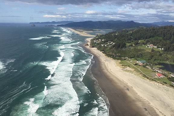
The Oregon Coast near Seaside.

By now, we were hungry. Two breakfasts had filled us before noon, but skipping lunch hadn’t gone unnoticed. Don had been texting back and forth with his wife who would have a hot dinner waiting when we arrived at their Seattle area home.

We continued up the coast a bit more before heading inland not far from Astoria, where the Columbia River meets the Pacific Ocean. This was, by far, the longest stretch of the Pacific Coast I’d flown in one day: more than 400 miles.

Don navigated northeast toward his house. It was all familiar territory to him — I didn’t fly much west of the Cascades. We flew east of Olympia and right over the top of the airport at Puyallup. From there, it was only a few minutes to Don’s place.

My iPad, with Periscope running, broadcast the approach in typical low-def quality.

Don let me take the controls and guided me in. I’d flown to his house before a few times but honestly couldn’t remember much about the approach. He had to keep pointing out landmarks and reminding me to slow down. It is tight — that’s for sure — with a steep approach between tall trees into a clearing beside his garage. I had Periscope running on my iPad in its cradle and recorded the whole thing.

And then we were on the ground, the long part of my journey over.

Resting Up

We went in and had something to drink while Don’s wife, Johnie, finished making dinner. Penny played with their new dog and ran around their grassy yard occasionally taking a detour to terrorize their chickens through the fence.

After dinner and a nice dessert, I went out to the barn with Don to see the two cows they’d “rescued.” They were huge. I really wish I’d had the presence of mind to take a photo, but I was so shocked by what I was looking at that I simply didn’t think of it.

I hit the sack in the guest room pretty early. I was still fighting a cold I’d had for at least three weeks and was exhausted. I slept well with Penny at the foot of the bed.

Seattle Area to Wenatchee

In the morning, after letting Penny out and then taking a quick shower, I dressed and met my hosts for breakfast. It was overcast and questionable (as usual) as to whether I’d make it across Snoqualmie or Stampede Pass. The automated weather station at Stampede was reporting half-mile visibility, which was enough to get through legally. But what about the rest of the flight? There was no accurate weather reporting in other places in the mountains. The only way to find out whether I’d make it was to give it a try. If I couldn’t get through, it was a long flight around the Washington Cascades to the Columbia River Gorge. I was hoping I wouldn’t have to go that way.

Don's Heliport
Another cloudy morning at Don’s place.

After thanking my guests and saying goodbye, I did a quick preflight, added some oil, and climbed on board with Penny. Then I started up and warmed the engine, setting up my iPad and iPhone with weather resources and Firelight maps to guide me while I waited. When the helicopter was ready to go, I picked up into a hover, turned 180 degrees over the driveway, and climbed out through the trees the way I’d come.

I had ForeFlight’s track log feature enabled during the flight, so I know exactly how I went. Originally, I thought I’d hook up with I-90 and follow that through the mountains at Snoqualmie Pass, which is at 3004 feet. But that would require me to head north quite a bit before heading southeast. It didn’t make sense to go out of my way. So instead, I followed the course of the Green River up into the mountains, aiming for Stampede Pass, which is higher at 3800 feet, but had that handy ASOS weather station. The weather there was reported at 1/4 mile visibility with mist, but I knew that could change at any time.

My Route
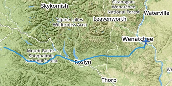
An overview of my route from the Seattle area to Wenatchee. Not exactly a straight line.

In the meantime, the flight was pleasant, even under the clouds, taking me over the Howard A Hanson Reservoir and a few communities that were no more than named points on the map. The area below me was thick forest, for the most part, with a road following the river for part of the way. I wish I could have taken pictures, but I’m a terrible photographer when I’m flying. I really missed my GoPro on that flight.

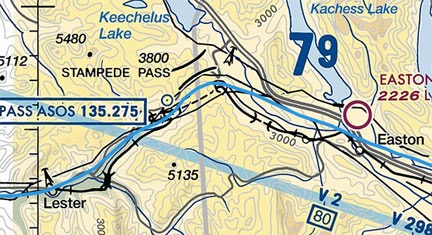
I steered up another canyon to the left just past Lester, heading for Stampede. The only roads were forest roads now as I climbed with the hills, getting ever closer to the cloud bottoms. Soon, I could see Stampede Pass ahead of me. I’d forgotten all about the wires that crossed through the lowest (and clearest) spot. I’d have to cross at a higher point a bit east where the clouds seemed to touch the ridge line. I could tune into the ASOS by that point; it was still reporting 1/4 mile visibility with mist.

My route over the pass
Here’s a closeup of my route (the blue line) through the Stampede Pass area on a Sectional Chart. I crossed the mountains just southeast of the pass, not at all interested in crossing over all those wires.

I slowed to 40 knots and creeped up to the ridge. I knew the rules I’d set for myself, rules that had never failed me when dealing with weather flying: if I could peek over the ridge and see the ground and my path ahead, I’d cross the ridge. Otherwise, I’d have to backtrack or find another place to cross.

I peeked, I saw. The ground dropped away ahead of me as I crossed the ridge near the pass and descended down into the valley beyond. Soon I was flying over I-90, past the lakes near Roslyn and Cle Elum. I steered east northeast, then due east, then northeast, direct toward home.

I crossed the mountains south of Wenatchee at Mission Ridge and made a slight detour to check out the slide damage areas at Whispering Ridge and Joe Miller Road. Then I made a beeline for the airport to get some fuel and take care of some paperwork with my mechanic.

A short while later, I was landing on my platform, which I’d left outside before heading down to Sacramento the previous day. It was good to get the helicopter put away.