One last photo flight and the long flight home.
Day One: Rushing to Russians
Day Two: Page, the windy city — and more
Day Three: Lots of flying
Day Four: Night flight on the Rez, rain, rest
Day Five: Rest, a great ferry flight, and a tall ship in the desert
Day Six: One last photo flight and the long flight home (this article)
I was ready to go in the lobby with my luggage at 6 AM the next morning. The motel — like most “standard” motels these days — offered a free breakfast. It was the usual collection of high-carb breakfast junk food and juice from concentrate. I was nursing a cup of weak coffee at 6:30 AM when Mike appeared. After loading the SUV with luggage and waiting while the two of them had a cigarette, we headed back to the airport.
We pulled the left side doors off the helicopter and stowed them in their SUV, which they parked alongside a hangar nearby. Then I fired up the helicopter and started the warmup process. It was cold that morning — 37° F — and my papered aircraft usually doesn’t like starting on cold mornings after spending the night outdoors. But that morning it started right up, ready for more.
The Flight
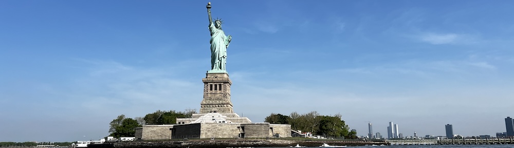
Dawn broke through a layer of haze as we started off toward Shiprock. Suddenly, my passengers were in a hurry. With doors off, my speed was limited to 100 knots, but I used it all and got out there just as the light was getting good.
We made several slow flights over the north-south ridge line, as close to the ridge as I dared, so they could shoot up the ridge with Shiprock in the background. With each pass, we got closer to the peak. The shadows from the ridge and peak were long but got shorter with every pass.
As Mike snapped photos, he made lots of ooh and aah sounds, punctuated occasionally with a soft wow. At one point, he showed me the image in the LCD panel of his camera. Wow was an understatement. I’m hoping he shares a lo-res copy of the image with me so I can put it here.
We kept at it for quite some time. Then they told me to head on back to Farmington. As we neared the airport, they shot a few more images of the town — mostly fields alongside the river. The tower cleared me to land and I set down on the pad. Then it was over.
Getting Ready for Departure
We put the doors back on and loaded in my luggage. We said some parting words, and shared hugs. I handed over the piece of paper I’d been using to keep track of all the flight times. Mike passes my costs along to his passengers based on the amount of time each of them flew and I’d been keeping meticulous records for him for the past six days.
They drove off and I placed my fuel order with the FBO girl, who was still on duty. She gave me a lift back to the FBO office so I could use the facilities and settle my bill. When she dropped me off at the helicopter again, I handed over a pair of tens: one for her and one for the previous day’s FBO guy.
A while later, I was in the air, heading southwest.
If you look at a Denver sectional — which is where you’ll find Farmington and the area around it — and you trace a route that’ll bring you toward the Phoenix area (on the Phoenix sectional), you’ll soon find that there isn’t much in the way of airports between the two points. I estimated the flight at just under 3 hours which I should be able to do with the full tanks of fuel I had on board. But having come close to running out of fuel on long trips across open desert before, I wasn’t planning on doing it in one shot. I wanted a fuel stop. That meant stopping at Winslow.
But how to get there? I wasn’t interested in overflying the Chuska Mountains. It was getting windy and I simply didn’t feel like being tossed around while I climbed over 8,000 foot peaks. If I went around to the north, I’d overfly Chinle. If I went around to the south, I’d overfly Window Rock. I chose south.
 I don’t remember too much about the flight. I know that the first 40 to 50 minutes was spent flying first across some half-neglected farmland and then over relatively flat open and deserted desert. One highlight was seeing a pretty large herd of sheep being tended by a single dog; when he heard me coming, he rounded all the sheep up into a frantic group. After that, I got my camera ready for other photo ops. But the only interesting things I passed were the remains of old hogans or corrals.
 Yes, I was still on the Rez. The Navajo reservation, as I’ve said earlier in this narrative, is huge. I was flying from near its most northeastern point (Farmington) to near its most southwestern point (near Flagstaff). It would take me about an hour and a half just to make that flight.
 I rounded the southern end of the Chuska Mountains and adjusted my course slightly to the west to overfly Window Rock. I started to climb. The terrain below me was rising with tall pines all around. The few homes I flew over looked more like winter residences than year-round homes.
A few very interesting rock formations appeared just outside of Window Rock. I tried to get photos but discovered that my camera’s card was filled. (I’d left photos on it from a previous trip when I started this one and didn’t even know it.) I managed to delete a photo (while I was flying!) so I could take one as I came into town.

Then I was over Window Rock, which is named for a huge hole in a rock on the north side of town. The government offices are built nearby it and there’s a park so you can walk right up to the formation. I’d been there on the ground when visiting the Navajo Nation County Fair in previous years. This time, I saw it but couldn’t snap a photo. How annoying!
I reprogrammed my GPS for my next waypoint: Winslow and made a slight course adjustment. For a while, I continued flying over tall pines. Then the terrain started to slope down and the pines faded away. I fumbled with my charts to switch to the right area on the Phoenix sectional. Although I was using a GPS for navigation, it’s always a good idea to know where you are on a sectional. I used landmarks such as powerlines and roads to track my route. Soon I was in the painted desert, flying between low buttes in an almost barren terrain.
As I neared Winslow, I tuned into its frequency. A helicopter was just departing to the south. An airplane was on its way in. I saw the Little Colorado River’s green belt and the town beyond it. A while later, I was landing on the ramp.
Oil Leak and a Long Walk
The first thing I noticed after shutting down were the spots of oil all over the ground under the helicopter. Oil from the helicopter.
Now I’d been noticing a higher-than-usual oil consumption during the past few days. I’d also been noticing more oil than usual in the engine compartment, which I try to keep clean. I’d been at a complete loss as to exactly where the oil was coming from. There wasn’t so much oil that it was a serious problem. It was more of an annoyance. Something to get looked at but not something to stop flying over. After all, it was holding enough oil to keep gauges in the green.
I called Ed, my Wickenburg (engine) mechanic and talked to him about it. Could he look at it as soon as I came in? I had a 6-day excursion coming up on Sunday (four days away) and would be in deep doo-doo if I couldn’t do it. He promised to check it out when I flew in.
I went with the FBO guy to the FBO office and put in a fuel order to top off the tanks. The girl at the counter ordered a cab to take me into town. The cab dispatcher said it would be 15 minutes.
I plugged my iPod’s charger into an outlet at the FBO office. (Guess I didn’t mention that I’d been listening to music during the entire flight. The iPod connects to the helicopter’s intercom system so it automatically cuts out when someone comes on the radio.) Then I used the restroom and stepped outside to wait. It was 9:45 AM, back on MST. (I was off the Rez.) A beautiful day with light winds. I waited.
And waited.
After about 15 minutes, I called the cab company to see what the status was.
“I told her it would be a while,” the woman snapped at me.
“Well, it’s a nice day so I’m going to start walking,” I told her. “So if you see someone walking on the side of the road toward town, it’s me. You can pick me up where you find me and take me the rest of the way.”
“I have two other people in front of you,” she said.
“Fine,” I replied.
We hung up and I started walking.
You can probably figure out the rest. I walked all the way into town. It’s about a 2-mile walk and I can’t say it’s very interesting. But the weather was nice and I can use the exercise. I just wish I was wearing my walking shoes instead of those damn Keds. They’re simply not designed for long distance walking.
By the time I got to La Posada — 45 minutes after I’d started walking — I was hot and a bit cranky. They sat me at a table near the window so I could look out over the gardens and the train tracks. I ordered eggs on polenta with green sauce — my favorite breakfast there — and started tanking up on iced tea. Then I paid my bill and went to the hotel desk to see if they could call a different cab company to pick me up.
The girl at the desk offered to run me over to the airport. We had a nice drive and, at the end, I gave her the money I would have given the cab driver. “Lunch on me,” I told her. That was two fares the cab company lost that day.
The Last Leg
I settled my bill with the FBO and walked out to the helicopter. The oil problem didn’t seem any worse, so it evidently leaked only when the engine was running. I added a quart of oil, did a quick preflight to make sure I wasn’t missing anything obvious, and climbed on board. Then I started up, warmed up, and headed southeast toward Sedona.
Although a straight-line route would have taken me south of Sedona, it also would have kept me away from any airport that I could have used if the oil leak started giving me bad indications — like loss in oil pressure or increase in oil temperature. So I chose a route that put several airports within range: Flagstaff, Sedona, Cottonwood, Prescott. I didn’t actually overfly any of these places. I just kept them within a short flight distance in case I felt a need to land. Sure, you can land a helicopter almost anywhere, but landing in the middle of nowhere, miles from help, isn’t exactly the best situation to put yourself into.
But everything was fine. I completed the flight in just under an hour and a half, flying a route I’d taken many, many times. It felt good to see familiar mountains and roads again. And it even felt good to see Wickenburg Airport in the haze as I descended from the Bradshaw Mountains.
Oil Leak Investigated
I was still cooling down the engine on the ramp when Ed came out of his hangar. He stood patiently nearby until the blades stopped spinning. I opened up the side panel, where he could clearly see oil splattered all over the top of the battery box. He’d cleaned the box cover when he’d done an oil change before the trip. I’d cleaned it at least twice during the trip.
His main concern was that the oil leak was coming from the filter — which would mean he’d screwed up on the oil change. But that was not the problem and I knew it wasn’t. Ed is extremely conscientious about his work. Heck, the man won’t even give you a bill for work done until he knows he’s done it right.
I offloaded my luggage and towed the helicopter into one of Ed’s hangars. He went to work on it. I was still at the airport a while later when he came up with his verdict: the oil was leaking from one of the engine’s connections to a magneto. All he had to do was tighten a bolt.
We pulled the helicopter out onto the ramp between two rows of hangars and let it down off its towing equipment so its skids were flat on the ground. Although I hardly ever run it up near the hangars, there was no one around other than Ed, his assistant Kenny, and me. All the hangars were closed. So I fired it up while Ed sat a safe distance away, looking at the affected area through a pair of binoculars. I ran it at idle speed (55% RPM) and then at warm-up speed (68% RPM) for about five minutes before Ed signaled that it was okay to shut down. The leak had been fixed.
I put the helicopter away and headed home for some well-deserved rest.
 Elizabeth arrived at 7 AM and I was ready to go. We started off with a little tour of Howard Mesa. Elizabeth used my camera to take a photo of her house (see photo). I pointed out all the little cabins and sheds and trailers that you can’t see from the road. Then we went up to Valle and followed 180 east. She showed me where some friends of hers had just bought some land and I showed her Red Mountain. From there, we headed north. It had rained the day before and I was interested in seeing if there was water in the Little Colorado River. There wasn’t. I took her to the Little Colorado Gorge lookout, just outside the Grand Canyon SUA, and was disappointed to see the canyon bottom just as dry as it had been the last time I flew over.
 As we flew along the cliffs near The Gap, she admitted that she’d never been to Page. I told her a little about it. I figured we’d land at the airport, then take the free shuttle to the marina where there was a restaurant. But when I pointed out the Vermillion Cliffs in the distance ahead of us, I got a better idea. Marble Canyon. The runway is right across the street from the lodge and restaurant. Elizabeth was game. Actually, I don’t think she cared where we went. I didn’t really care either, for that matter. Elizabeth took a few photos of the landscape we flew over, including this shot in the Cedar Ridge area. She was fascinated by the geology of the land, especially the tilted layers of multi-colored rock. I explained how some of the more obvious formations were made and told her I had a book about Grand Canyon geology that probably explained a lot more. We were flying over the Navajo Reservation and, when we were away from the main road, we saw lots of ruins of old hogans and animal pens. That’s the kind of stuff that interests me. I especially liked the animal pens that had been built into natural rock formations — like a box canyon with its open side fenced off or animal pens built entirely of stone.
 We crossed the Colorado River at Marble Canyon and landed at Marble Canyon’s airstrip. I set down on the dirt ramp area and shut down. It was about 8 AM and the morning sun was still low enough to make the Vermillion Cliffs behind us…well, vermillion. In my opinion this is the most scenic spot anyone can use as a backdrop for a photo of their aircraft. In fact, it’s enough of an excuse to fly in to Marble Canyon. Just be advised: the runway is very narrow.
 We had breakfast at the lodge restaurant. It wasn’t anything special. I think our waitress may have been more interested in listening to her MP3 player than serving us. Afterwards, we climbed back on board and took off to the north. A plane had just taken off from Marble Canyon’s runway, so I had to stay a bit low until it passed over us. (I didn’t use the runway.) Our flight path gave us great views of Navajo Bridge and the river at Lees Ferry, as well as Horseshoe Bend further upstream. Elizabeth kept snapping photos, like this one, which kind of gives you an idea of the visibility in a helicopter. Don’t mind the reflections in the bubble; I was wearing my loud white pants again. And yes, that’s my hand on the cyclic.
 I check out a few points of interest from the air.
 I headed northeast, right into the sun. Not good. I’d forgotten to put my hat on and the sun was shining right in my face, flickering through the blades. (I hate when that happens.) So I moved my headset down around my neck, put my hat on, and then put my headset back over my ears. Doesn’t sound like a big deal, does it? Well, you try to do it with one hand — your left hand. It was worth the struggle, though. The hat shaded my eyes nicely. I hit route 180 and followed it east, toward Flagstaff. I wanted an aerial view of Red Mountain, which I wrote about in another blog entry a few weeks ago. I had my camera and managed to snap two photos. Here’s one of them. Neither really shows the mountain well, but it’s hard to take pictures left-handed while flying a helicopter right toward a mountainside.
 This was my second trip along the Little Colorado River. It isn’t a very exciting flight, but it is mildly interesting. There are a few remains of Navajo homesteads and something that looked like an old mine. The highlight, of course, is usually the Grand Falls of the Little Colorado. But without any water falling over the big cliff, it was extremely disappointing. From that point, I headed pretty much straight toward Winslow cutting across the high desert, 300 feet above the ground at 100 knots.
 I headed west along I-40 for a short while, then spotted the “mountain” formed around Meteor Crater and headed straight toward it. I’d tried to get a summer gig at the Crater and they wanted me, but they also wanted $15 million in insurance, which I cannot get. (I don’t know anyone who can, either.) I like to fly over the crater when I’m in the area. I think it’s the best view; about 400 feet above the rim. I circled it once (D) and took a few pictures, then headed back toward I-40 again. I followed I-40 for a while, then decided to follow the traces of old Route 66. I did that past Twin Arrows, Winona, Flagstaff, Belmont, and Parks. It’s interesting the way the road fades in and out of existence along the way.
 When I got close to Williams, I caught sight of the black smoke spit out by the Grand Canyon Railroad’s steam engine. I caught up with it just short of Howard Mesa and managed to take a halfway decent photo of it from the air. (Remember, I’m doing this left-handed, and, in this case, through the passenger side window, while flying a helicopter. So cut me some slack.) Back at Howard Mesa, I followed the state road up to my property. I flew low and slow, trying to check out the road work they’d been doing. They were still working on it. I probably gave the road grader guy a mini heart attack when I passed him 50 feet off the deck about 100 feet to his left at 60 knots. (He’ll have something to tell his wife tonight.) I set down on my pad and shut down. I’d logged 2.1 Hobbs hours and had gotten a good fix.
 The hotel wasn’t very impressive from the outside. But step inside and WOW. The restoration work was incredible. Although I didn’t much care for the weird paintings that adorned the walls — paintings that probably have architect and designer Mary Jane Colter spinning in her grave — the place was beautiful.
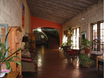 Afterwards, I explored the place, checking out the various public rooms on the main floor. I had my camera with me and snapped about a dozen photos so I could show Mike what the place was like. Beautifully decorated, beautifully restored. There was a garden in a courtyard out front and a lawn with covered patio in back facing the tracks. It was easy to imagine what staying at this place had been like years ago. I grabbed a brochure, noted the moderate room rates, and decided to talk Mike into making the trip for a weekend stay sometime in the future.