I fly from one gig to the next.
I had two long distance flying jobs this past week: one in Page, AZ and the the next in Lake Havasu City, AZ. Although the two cities are on the Colorado River, they’re 200 miles apart by air.
My Page job ended at around 6:30 PM on Thursday. With sunset less than an hour away and dark clouds on the southern horizon, flying home was not an option. That didn’t matter; I was prepared for an overnight stay.
The FBO guy at Classic Aviation gave me the courtesy van for the night and I drove into town. A while later, I was checked into a comfortable first-floor room at the Best Western Hotel, with a “Manager’s Special” rate of only $65. Dinner was across the street at the Lake Powell Steakhouse, one of those small-town restaurants that features a soup and salad bar no one would miss if it weren’t there. They had a wine list and I ordered a half bottle of Clois du Bois cabernet — which actually came in a little bottle with a real cork — to go with my prime rib. I couldn’t finish the wine with dinner, so I corked it back up and took it back to my room, where I finished it off out of a styrofoam coffee cup.
I watched a little television before passing out at around 9 PM. I was awake at 3 AM. I’ve been having trouble sleeping lately — have a lot on my mind. I spent some time writing about the day before. Then, at 5 AM, I washed up, dressed, and packed up. I was getting back into the van at 5:30 AM.
 I dropped off the van at the airport, leaving the keys tucked inside the van’s logbook under the seat with a $10 contribution for fuel. It took five tries to get the combination right on the locked gate to the ramp. There was no one around. I walked out to the helicopter just as the sun was rising over Tower Butte and Navajo Mountain to the east. The air, which had been completely still, now stirred to life with a gentle breeze. There was enough light for a good preflight and I took some time stowing my bags and the life jackets so I’d be organized when I arrived at Havasu.
 I started the engine and warmed it up, giving the engine plenty of time to get to temperature. (Take care of your engine and it’ll take care of you.) At exactly 6 AM — right on schedule — I raised the collective, made a radio call, and took off toward the lake. I swung over the dam for a look and a photo before heading down the Colorado River, over Glen Canyon.
I had a long flight ahead of me.
 My flight path would take me south along the eastern edge of the restricted Grand Canyon airspace. In a way, it was ironic — less than two years ago, I’d earned part of my living as a pilot flying over the canyon every day, but now I can’t fly past the imaginary line that separates that sacred space from the not-so-sacred space I was allowed to fly. That didn’t mean I didn’t have anything to see. As I flew past Horseshoe Bend and over the narrow canyon, I could see reflections of the canyon wall on the slow moving river below. To the west were the Vermilion Cliffs with Marble Canyon at their base.
The air was wonderfully smooth — as it usually is early in the morning. I could fly at dawn every day. It’s cool and crisp and clear. The sun hasn’t warmed the desert yet so there are no thermals to bump you around. The helicopter goes exactly where you tell it to. Sometimes, it’s like sitting on a lawn chair in an enclosed bubble, guiding yourself over the landscape with gentle pressure on the stick in your right hand. My iPod was connected and turned on with hours of classic rock music to keep me entertained while the radio remained quiet.
 I detoured slightly to the east, keeping to the left of the green line on my GPS that marked Grand Canyon’s airspace. The red rock terrain gave way to rolling hills studded with rock outcroppings and remote Navajo homesteads. I flew low — only a few hundred feet up — enjoying the view and the feeling of speed as I zipped over the ground, steering clear of homes so as not to disturb residents. I saw cattle and horses and the remains of older homesteads that were not much more than rock foundations on the high desert landscape.
Ahead of me, past the Little Colorado River Gorge and route 64, were the cliffs that marked the southern boundary of the reservation. I’d have to climb 2,000 feet to clear them. But above them was a layer of low clouds. From my position near the ground, it almost looked like a fog bank sat on top of the higher plateau. That would be bad news and mean a course change. I started to climb, leaving the earth behind.
Once I was level with the cliff’s edge, I could see that there was some clearance between the plateau and the clouds above it. I reached the southeastern corner of Grand Canyon’s airspace and programmed my GPS for a direct course to Lake Havasu City airport. I turned to the desired course, putting the little airplane on the pink line, and crossed onto the plateau about 300 feet over the top of the cliff. The clouds closed in above me. I split the distance between them and the high desert terrain, flying at about 8,000 feet MSL.
I knew the terrain below me well. Coming from the south, the terrain rose gradually to its highest point at the edge of the cliff. Now, coming from the north, it would descend. I was moving southwest, over tall pines and meadows just like the ones I flew over when I flew at the Grand Canyon. My handheld GPS showed a maze of forest roads and I was surprised to see a handful of ranches I’d never noticed before. But I was on a different course now, not heading toward Howard Mesa or Wickenburg.
The air remained smooth, despite the clouds. The weather was worse to the south. It was cold in the cockpit — although I’d worn long pants, I’d neglected to put a sweatshirt on over my polo shirt. I pulled the heat on.
I switched to Grand Canyon airport’s ATIS frequency. It was still early and the tower hadn’t opened yet. The automated system gave me the winds (light out of the south) and altimeter setting. Then I switched to the tower frequency. I was just passing between Valle and Tusayan when I heard a Scenic Airlines plane make a CTAF radio call. I’d hear him three more times before he finally landed and I was miles away.
The cloud bank ended abruptly, leaving me in the sunshine of a beautiful day. The ponderosa pines were gone and I was flying at about 6500 feet now, over remote ranch land. I’d set my sights on a mountain in the distance to keep on course and the mountain was getting ever closer.
 Then there were more homes beneath me and pinon and juniper pines. Wisps of low clouds clung to the mountains at my altitude. Past the mountain I’d been aiming for was the town of Seligman on Route 66 and I-40. I crossed over with a quick radio call to the airport and kept going.
Now I was flying over completely new terrain. It was a pleasant mix of tall pines, rocky outcroppings, and rugged mountain peaks. There were a number of nice but mostly small custom homes on large lots below me. They looked, for the most part, deserted — like vacation homes. A sort of Howard Mesa where they actually cared about what people built.
I followed the pink line over a mountain range, flying at about 6,000 feet MSL. Then came a familiar valley — the one route 93 follows up to Kingman. The Big Sandy River was below me and the Hualapai Mountains were in front of me. Rather than dropping down to the valley floor, I kept high, crossing at at least 3,000 feet above the ground so I wouldn’t have to climb again to cross the mountains. At that altitude, I seemed to move at a snail’s pace, although my GPS indicated 120 knots groundspeed. I still had to climb to clear the mountains.
All the time I flew, I kept checking my clock with my GPS’s ETE. Throughout the flight, it appeared that I’d make it to Havasu with about 5 minutes to spare. My airspeed was limited by my altitude — I couldn’t pull as much power or fly as fast at 6,000 feet as I could at 3,000 feet. With that last mountain range behind me, I descended quickly toward the valley floor, bringing my airspeed up to 120 knots with only a slight reduction in power. When I was about 500 feet above the valley, I brought power back in and kept my airspeed at 120 knots.
I switched to Havasu’s frequency and heard a plane call in. I was almost there. Then I passed between two small peaks and followed a wash to the east side of the airport. After two radio calls, I crossed the runway and set down on the ramp.
It was exactly 8 AM.
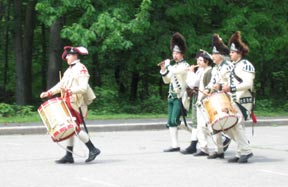 The first treat was the re-enactment stuff going on. I don’t know if they do this every Sunday or if we just happened to stop by on the right day, but there were men in revolutionary war uniforms doing the kinds of things the soldiers did back then. Like marching around with a drum and fife. Or with guns. Or setting up a camp near the mortar lobbing area. Or building a shelter without any modern tools.
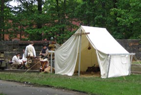 I don’t know why these guys were there, but they were definitely into it. Their outfits looked great — but a lot cleaner than they would have been 230 years ago. Sadly, there weren’t many spectators. The park was pretty empty. It was as if they were performing for themselves. Maybe something was going to start later on. We didn’t hang around. We had dim sum to eat.
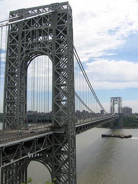 We also spent some time at one of the lookouts, watching the bridge and the river flowing beneath it. I took some pictures (of course). And I can recall some of the facts that I’d read about the bridge while in my hotel room.
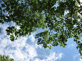 Anyway, I also took some time to lay back on the bench and look up at the sky through the leaves of an oak tree. It was nice to be among trees that were a good deal taller than I am. The area is lush with vegetation, like a jungle waiting to reclaim the land.
 I’d woken that morning in Montana, at a friend’s house, and had taken the scenic route south, through Yellowstone National Park. South of that park, I reached Jackson Lake with this late afternoon view of the Grand Tetons.
 I couldn’t remember where this photo was taken, either. I knew it was in Maine and I knew I’d taken it on one of our outings with John and Lorna. So I e-mailed Lorna a copy of the image and asked her. The response came back almost immediately: Samoset Resort in Rockland, ME.
 You also can’t see the building at the end of breakwater about a mile from where this photo was taken. Here it is. It was a lighthouse and apparently still functions as one. But it’s closed to the public, so you can just walk around it or onto its stone steps. We spent some time sitting out in the sun, watching the boats go by. It was a peaceful, relaxing place. There was some fog in the trees on the other side of the channel — the same fog we’d walked through earlier in the day when visiting the Owl’s Head Lighthouse. (Did I get that one right, Lorna?)
 I took this photo of John and Lorna on the way back to the car. John’s not an easy guy to get a picture of. It seem like every time you tell him to stand still and pose for a picture, he acts like he doesn’t believe someone’s really going to take his picture. So you have to take a few of them in a row for one of them to come out natural enough to use. This one gets them both.
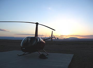 I dropped off the van at the airport, leaving the keys tucked inside the van’s logbook under the seat with a $10 contribution for fuel. It took five tries to get the combination right on the locked gate to the ramp. There was no one around. I walked out to the helicopter just as the sun was rising over Tower Butte and Navajo Mountain to the east. The air, which had been completely still, now stirred to life with a gentle breeze. There was enough light for a good preflight and I took some time stowing my bags and the life jackets so I’d be organized when I arrived at Havasu.
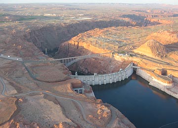 I started the engine and warmed it up, giving the engine plenty of time to get to temperature. (Take care of your engine and it’ll take care of you.) At exactly 6 AM — right on schedule — I raised the collective, made a radio call, and took off toward the lake. I swung over the dam for a look and a photo before heading down the Colorado River, over Glen Canyon.
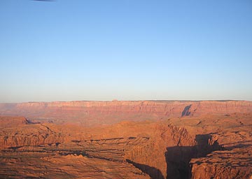 My flight path would take me south along the eastern edge of the restricted Grand Canyon airspace. In a way, it was ironic — less than two years ago, I’d earned part of my living as a pilot flying over the canyon every day, but now I can’t fly past the imaginary line that separates that sacred space from the not-so-sacred space I was allowed to fly. That didn’t mean I didn’t have anything to see. As I flew past Horseshoe Bend and over the narrow canyon, I could see reflections of the canyon wall on the slow moving river below. To the west were the Vermilion Cliffs with Marble Canyon at their base.
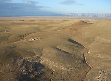 I detoured slightly to the east, keeping to the left of the green line on my GPS that marked Grand Canyon’s airspace. The red rock terrain gave way to rolling hills studded with rock outcroppings and remote Navajo homesteads. I flew low — only a few hundred feet up — enjoying the view and the feeling of speed as I zipped over the ground, steering clear of homes so as not to disturb residents. I saw cattle and horses and the remains of older homesteads that were not much more than rock foundations on the high desert landscape.
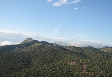 Then there were more homes beneath me and pinon and juniper pines. Wisps of low clouds clung to the mountains at my altitude. Past the mountain I’d been aiming for was the town of Seligman on Route 66 and I-40. I crossed over with a quick radio call to the airport and kept going.