I take Jack the Dog and my Jeep on some more back roads south of the Grand Canyon.
I started off with the idea of taking a photo of the Grand Canyon Railway’s steam engine on its way from Williams to the Grand Canyon. But rather than wait at one of the places where the train runs close to Route 64 or crosses a road nearby, I wanted to photograph the train in a more remote area.
At least that’s the excuse I used for the drive.
I started by taking the back windows off the Jeep. If I was going to have Jack in the back, I wanted all his dog hair to fly out the windows — not stick to the seat. Besides, he likes to stick his head out the window while we drive and I didn’t want him up front.
I also packed up a small picnic lunch of brie cheese, crackers, salami, apple, orange, and two biscotti. I put all this food in a plastic container with a napkin and knife and sealed it up. Then I stowed it in my big red cooler with three small bottles of water. I grabbed Jack’s water dish — he’d rather drink from a dirty puddle than a strange water bowl — and packed everything in the Jeep.
On the electronics side, I brought a camera and my video camera. I also brought along my aviation radio. I knew that where I was going, my cell phone would be useless and this radio would provide emergency communication if I got stranded somewhere too far to walk out. If I needed to, I could tune into the Grand Canyon Airport’s frequency and talk to an incoming or outgoing plane. That plane could relay my message to the Tower and they could relay it to someone who could help.
Of course, I also brought my GPS and my Kaibab National Forest map.
Jack and I headed north from Howard Mesa on Route 64, stopping for gas, ice, and a gallon jug of water at Valle. We continued north, making a left just past the high tension power lines onto the Willaha Road. This partially maintained, east-west road crosses the high desert from Route 64 to a place known as Havasu Hilltop — a parking area with a trailhead and helipad for access to the Havasupai indian village of Supai in Havasu Canyon. According to my 1995 map, the road was not complete. The map was wrong; the road was not only complete but in excellent condition from Route 64 to the Grand Canyon Railway’s tracks and beyond.
 The road crossed the tracks at a place called Willaha. Formerly a train station, the site has the ruins of a building, foundations of at least one other building, and a huge cattle holding pen overgrown with grass and weeds. I could imagine ranchers moving their cattle to this spot, putting them into the pens until the train with cattle cars stopped at the station. Then the cattle would be moved up onto the train and brought to market. Nowadays, the only train that uses the tracks is the Grand Canyon Railway, which runs one or two trains a day on scenic rides between Williams and Grand Canyon. I don’t think any cattle have passed through the corral in years, if not decades.
We crossed the tracks and headed west. I had a crazy idea that we’d go out to Hilltop and see what was going on out there. I checked my GPS to see how far it was — it was beyond the range of my map. It was more than 20 miles. I’d gone less than five miles when I decided to go back and stick with my original plan.
 Back at the tracks, I took a left, heading northbound on a two-track road on the west side of the tracks. This road was not on my map, but it was on my GPS. It was easy enough to follow, although it did have quite a few gates to pass through. Most of them were drag gates, like the three-way gate shown here. You may have heard this type of gate referred to as a “cowboy gate” because they’re relatively common out on the range where only the cowboys go.
A drag gate is basically a continuation of a barbed-wire fence, but with a moveable fence post. Each time I approached one, I’d pull right up to the gate and get out of the Jeep. I’d approach the side of the gate with the moveable post, lift a loop of smooth wire off the top of the post, life the post out of a similar loop out the bottom, and drag the gate to the opposite side, opening it wide enough to get my Jeep through. I’d drop the post there, walk back to the Jeep, drive through the gap, and then get back out of the Jeep. Then I’d pull the post back to close the opening, stick the bottom of the post into the fixed loop, and pull the top of the post to make the gate wires taut. I’d pull the top loop of wire over the top of the post, thus locking it in place.
This particular gate was the most difficult I’d ever had to close. I put all my weight against it — you’d think that would be enough — to pull it taut, and still couldn’t get the top loop over it. I had to fiddle around with the position of the loop at the bottom. Still, I barely got the top loop over.
The road followed the tracks north. In most places, it was both smooth and dry. But in some places, water had gathered in the wheel ruts and that water was muddy. I drove through the first spot like that and managed to get mud all over the Jeep as I slid around in the muck. The next muddy spot I reached showed evidence that someone else had driven around it, so I did the same. In other places, the road climbed up a rocky outcropping and got rough with broken rocks, forcing me to slow down. I certainly didn’t want to break a tie rod or something out there.
During the entire ride, Jack the Dog stood in the back seat, sticking his head out one window or the other. When we went through mud and it started flinging up, he’d pull back into the Jeep until the mud stopped flying. He was a having a great time. For him, it was almost as good as riding in the back of the pickup truck!
We reached Anita Station, where several roads intersected at the remnants of another cattle pen. Jack and I got out and walked around a bit. I saw the remains of several other buildings, reduced to mere concrete slabs. It was already close to 11 AM and I expected the train soon. But I couldn’t hear it coming, nor see its black smoke on the horizon. I decided to continue up the two-track road.
I gave Jack some water and we climbed back into the Jeep, continuing on our way. The road forked and I chose the fork closer to the tracks. It got very rough, with lots of broken rock on the road. The terrain was changing, with more rocky outcroppings and hills. We were less than 15 miles from the South Rim of the Grand Canyon, due south of Dripping Springs. The terrain would climb with hills and valleys all the way to the Rim.
By around 11:30, I had enough of the road. I pulled to the left side, as far from the tracks as I could. We were less than 20 feet from the tracks here, on a rise of land. I thought it would be a good place to take a photo of the train. I gave Jack some more water and told him to stay in the Jeep. I got out, scouted what I thought would be a good place for the photo, and waited.
The minutes ticked away slowly. No sign of the train. I remembered, from my days as a pilot at the canyon, that the train would go past the airport at about 11:30. It hadn’t passed us yet. Where was it?
I spent some time examining the map on my GPS. I discovered that the two-track we were on wasn’t on either the GPS or the map. No wonder it was in such bad shape. It was probably a maintenance road for the tracks.
 I heard the train coming and returned to my photo spot. As the train came puffing into view, I realized I’d picked a terrible spot for photos. I was too close to the tracks and there were too many trees in the way. For some reason, I’d imagined the train being bigger. It wasn’t. I offer this photo as an example of a good plan gone bad. I laughed at myself as the train passed and I walked back to the Jeep.
But I’m not giving up! I’ll try again, perhaps one day next week.
We backtracked to Anita Station, then turned left and crossed the tracks. We were on FR 347 now, heading east. If we followed that road for about seven miles, we’d end up at Route 64. So I turned left again, at FR 306, heading northeast. This road, like FR 347, was maintained — the grader had been parked near Anita Station — so it was easy going. But the mile markers indicated that I’d soon be back at Route 64, this time near Grand Canyon Airport. I made another left on FR 2615A and followed that to the intersection with FR 2615, which was on my map. At that point, to continue north on FR 2615, I’d have to go through a gate at an enormous mud puddle. I was tired from the bumpy road and didn’t feel like dealing with puddles or drag gates. So I stayed right and followed FR 2615 back to FR 306.
A few miles down the road, I found another forest road that headed north. Although it was not on my map, I think it was numbered 634. I turned left and followed it. A few moments later, we passed through an open drag gate with what looked like coyote pelts draped over the fence posts at each side. Creepy.
I steered us down a narrow road that wound through the forest, then dropped into a small canyon. I could imagine the water gushing though this place in a heavy rainfall and was glad it was only partly cloudy. Sometimes the road was so scrubbed by flooding that it didn’t even look like a road. It looked like I was driving down a rocky canyon.
The canyon and road ended at an intersection: FR 2615 again. I wanted to go north, to the other side of the tracks. So I turned left. I realized about two miles down the road that left was wrong — it would just bring me back to the mud puddle — and backtracked yet again. I headed northeast on FR 2615, following it up Rain Tank Wash. The open meadow-like area closed up to another canyon and I followed the road through it. Although my map showed that the road ended not far after I’d gotten on it, I had become accustomed to roads continuing beyond their map ends. This one continued for a good two miles up the wash while steep walls and pine trees closed around us.
After a while, I realized that the road was getting fainter and tougher to follow. Then, suddenly, it ended, with huge blocks of stone in the way. I got out of the Jeep and went to investigate. The rocks looked natural, but I couldn’t imagine where they’d come from. They must have been placed there. But by what? Heavy equipment could not have traveled down the road I’d been on — it was just too narrow in some places. It must have been a natural end.
I checked my GPS. We were less than a half mile from Rain Tank, which was at the southwest edge of the Grand Canyon Airport property.
This was not good news for me. It meant I had to backtrack to the intersection and go back up the washed out canyon road. It was about five or six rough miles to FR 306. And I wouldn’t be any closer to where I wanted to be — at the railroad tracks northwest of the airport.
It was nearly 1 PM by this time and I was hungry. So I turned the Jeep around and started back down the road. I parked in the shade of a big pine tree, let Jack out, and set up a picnic lunch. I had a folding chair in the back of the Jeep and I used the cooler for a table. I poured out a generous helping of water for Jack. I settled down for lunch while he chased some kind of critter around the underbrush nearby.
While I ate, I consulted the map. According to the map, I wasn’t anywhere near a road. I checked the GPS. It told me I was on a road that went passed the rocks to Rain Tank. There were no other roads.
I finished up lunch and packed up. Jack and I got back in the Jeep. And I started back to Coyote Pelt Gate.
I was nearly all the way back to the gate when I saw an unmarked road heading northeast. It wasn’t on my map, but it was on my GPS. I made a left and followed it.
The road was lightly used and, in some places, extremely difficult to follow. But it wasn’t too rough. I was energized after my lunch and ready for adventure again.
The road followed a fence line for some time. There were bright pink surveyors’ ribbons tied to branches on some trees on the other side of the fence. The ribbons were relatively new — certainly not older than a month or so. There was no road on the other side, though, and I wondered whether people had come through on foot to place the ribbons. The barbed wire fence was in good shape and the ribbons were sometimes placed too far from the fence to be done by someone simply reaching over.
The road reached a clearing where the earth dropped away in front of us. There, in the near distance, was the approach end of Runway 3 at Grand Canyon Airport.
I continued along the road I was on, winding up outside the airport fence at the end of the runway. I reached an intersection. A right turn would have brought me back to FR 306 and, not long afterward, pavement. A left turn would take me back into the forest at the other side of the airport. I turned left.
The road wound near Rain Tank and forked. The left fork seemed to descend down into a small canyon. Could it be? I took the left fork. A few minutes later, I reached a point where the road was blocked off by big rocks. A sign said the road was closed to vehicles but open to hikers. I left the Jeep behind and took a short walk down the hiking trail. It looked familiar. I confirmed what I suspected with my GPS: I was 1/10 mile from the point I’d been stopped when I drove up FR 2615. The blocks had indeed been placed, most likely from this end of the canyon — just to place a 1/10 mile long hiking trail in Rain Tank Wash.
I backtracked up to the fork, then followed a series of roads through the forest on the northwest side of the airport. By this time, it was after 2:30 PM and I was tired enough to end my off-pavement explorations. I was still about five miles from pavement when I passed the only other vehicle I’d seen on my trip: a Forest Service pickup truck parked on the side of the road. Its driver was nowhere in sight.
The road I was on eventually dumped me on a back road in Tusayan. I turned right on Route 64 and headed south. I was tired and dusty. But I had one more bit of exploration to do.
More on that in another entry.
[composed on top of a mesa in the middle of nowhere with ecto]
train, off-road, explore, Grand Canyon, Jeep

 I won’t go into details about the roads I tried and the wrong turns I took. Suffice it to say that I finally homed in on it. After driving down a two-track road that cut diagonally across the main runway, I parked my Jeep right in front of the gaping hangar door.
 One thing is for sure: visiting the old airport and looking up at the faded paint over the door spelling out “Grand Canyon Airlines” has given me a real thirst for knowledge about the place. When I’m finished with my road trip book project and trip to Canada (for work), I might start doing a little research.
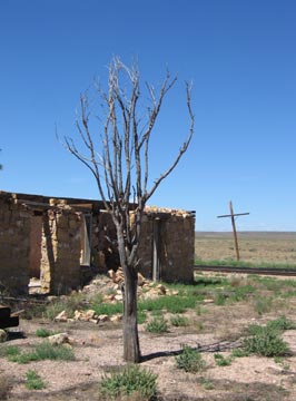 The road crossed the tracks at a place called Willaha. Formerly a train station, the site has the ruins of a building, foundations of at least one other building, and a huge cattle holding pen overgrown with grass and weeds. I could imagine ranchers moving their cattle to this spot, putting them into the pens until the train with cattle cars stopped at the station. Then the cattle would be moved up onto the train and brought to market. Nowadays, the only train that uses the tracks is the Grand Canyon Railway, which runs one or two trains a day on scenic rides between Williams and Grand Canyon. I don’t think any cattle have passed through the corral in years, if not decades.
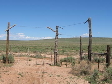 Back at the tracks, I took a left, heading northbound on a two-track road on the west side of the tracks. This road was not on my map, but it was on my GPS. It was easy enough to follow, although it did have quite a few gates to pass through. Most of them were drag gates, like the three-way gate shown here. You may have heard this type of gate referred to as a “cowboy gate” because they’re relatively common out on the range where only the cowboys go.
 The road followed the tracks north. In most places, it was both smooth and dry. But in some places, water had gathered in the wheel ruts and that water was muddy. I drove through the first spot like that and managed to get mud all over the Jeep as I slid around in the muck. The next muddy spot I reached showed evidence that someone else had driven around it, so I did the same. In other places, the road climbed up a rocky outcropping and got rough with broken rocks, forcing me to slow down. I certainly didn’t want to break a tie rod or something out there.
 We reached Anita Station, where several roads intersected at the remnants of another cattle pen. Jack and I got out and walked around a bit. I saw the remains of several other buildings, reduced to mere concrete slabs. It was already close to 11 AM and I expected the train soon. But I couldn’t hear it coming, nor see its black smoke on the horizon. I decided to continue up the two-track road.
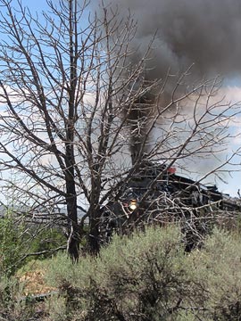 I heard the train coming and returned to my photo spot. As the train came puffing into view, I realized I’d picked a terrible spot for photos. I was too close to the tracks and there were too many trees in the way. For some reason, I’d imagined the train being bigger. It wasn’t. I offer this photo as an example of a good plan gone bad. I laughed at myself as the train passed and I walked back to the Jeep.
 The canyon and road ended at an intersection: FR 2615 again. I wanted to go north, to the other side of the tracks. So I turned left. I realized about two miles down the road that left was wrong — it would just bring me back to the mud puddle — and backtracked yet again. I headed northeast on FR 2615, following it up Rain Tank Wash. The open meadow-like area closed up to another canyon and I followed the road through it. Although my map showed that the road ended not far after I’d gotten on it, I had become accustomed to roads continuing beyond their map ends. This one continued for a good two miles up the wash while steep walls and pine trees closed around us.
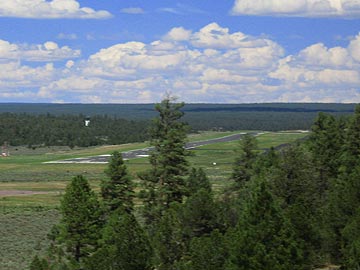 The road reached a clearing where the earth dropped away in front of us. There, in the near distance, was the approach end of Runway 3 at Grand Canyon Airport.
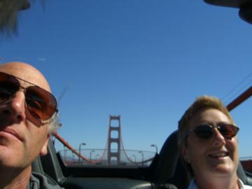 Mike snapped this photo as we were driving over the Golden Gate Bridge last week. He just e-mailed it to me with the subject line “Two Kids Having Fun.” I think that says it all.