A slow start to the day, a great flight to a beautiful place.
• On Someone Else’s Vacation (Again)
• Photos from My Trip: Day 1
• Photos from My Trip: Day 1, Part 2
• Sedona to Grand Canyon
• Grand Canyon to Lake Powell
• Lake Powell to Monument Valley
• About Goulding’s Lodge
I slept great at Page. I think it was the combination of a comfortable bed, good climate control (no need to run any heater or air conditioner), and a completely exhausted body.
I walked over to the Safeway supermarket, where there was a Starbucks, to get my morning coffee. It was a great day: clear, calm winds, blue skies, nice temperature. Or maybe it just seemed great because I’d slept so well. There’s nothing like a good night’s sleep to get you off on the right track for the day.
I had a bunch of chores to do before picking up my passengers at 10:45 at their hotel. One of them was a meeting with the Chief Pilot of a Page-based tour operator. I’m doing a custom video for them based on our Lake Powell footage and we needed to iron out details regarding the narration script and footage to be used. I also wanted to preflight the helicopter and remove the tie-downs. And pick up a book about the ill-fated San Juan Marina on Lake Powell. And do some networking around town.
I got all of this done — and more — before picking up my passengers and while they were out on their tour of Antelope Canyon. I also checked them out of their hotel, checked myself out of mine, and stowed all of our luggage in the helicopter.

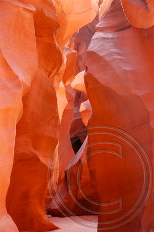
This is actually Lower Antelope Canyon. I made this photo on another trip. My passengers went to Upper Antelope Canyon, which is more accessible and looks a lot like this shot.
One of my passengers had eaten something the day before that didn’t agree with her and was feeling a bit under the weather when I picked them up. Fortunately, the symptoms had subsided by the time they went on their Antelope Canyon tour. When they returned, they were in high spirits and she was hungry for lunch. Since there was no rush getting to our next destination, I recommended a restaurant near the tour operator office and they went in for a meal. I spent the next hour doing some last-minute networking with a Hummer tour operator nearby.
By the time we got to Page Airport, it was well after 2 PM. Although winds had been forecasted out of the southwest at 20 mph, there was barely a breeze out on the ramp. We loaded up and took off uplake. We were the only aircraft out there — the radio was dead quiet.
The lake water was a mixture of glassy smooth areas punctuated with ripples caused by surface winds. Our ride, 500 to 1000 feet above the lake’s surface, was remarkably smooth. I pointed out all the buttes and bays and canyons I knew by name, then swung us past Rainbow Bridge for just about the best view you can get from the air.
From there, it was on to the Confluence of the San Juan River. We followed that arm of the lake up a bit, then turned toward No Man’s Mesa, crossed it, and descended into the valley west of Monument Valley. There are a bunch of dark red sandstone formations out there that few people ever see; an old hogan at the base of one formation provides some scale to its huge size.

The Goulding’s airstrip, photographed from my room at the lodge. Can you see my helicopter parked there?
We approached Monument Valley from the west and made a loop around the famous monuments on that side of the park. Then we went back for landing at Goulding’s airstrip. We spooked a herd of horses as we came in low across the runway. I set us down gently on one of the two helipads.
A van was down from the lodge before I had a chance to call. We were checked into our rooms, overlooking Monument Valley, by 4 PM local time. (The Navajo Reservation is on Daylight Savings Time; we were in Utah at that point.)
I took the rest of the afternoon off, shooting a few photos from the lodge property. The drawback of flying into Monument Valley is that once you get there, you’re pretty much stuck. There’s no mass transit, no rental cars, no taxis. The only way off the lodge property is to hitchhike or take a ground tour of Monument Valley Tribal Park. But there are plenty of nice views from Goulding’s Lodge, so it wasn’t difficult to get a few good shots. And everything you need is within walking distance: restaurant, shops, grocery story, gas station, laundry. So it’s not as if staying there is a hardship. It’s not.
Later that evening, I went up to the little theater on the property and saw a short video about the history of the Lodge. The night was dark and the sky was full of stars. As my fellow travelers settled down for the night, a deep silence surrounded me. In the distance, now out of sight, the ancient stone monuments loomed in the darkness.


 The writer is sitting up front beside me, taking notes and using my Nikon D80 to shoot images of what she sees. Although a good portion of the shots have some unfortunate glare — not much you can do about that when shooting through Plexiglas — many of them are really good. Like this shot she took of a herd of wild horses we overflew on the Navajo Reservation two days ago.
 I’m treating myself to a few of the activities my excursion guests get to enjoy. For example, on Tuesday, I joined the crew for a boat ride on Lake Powell that visited the “business side” of the Glen Canyon Dam before squeezing about a mile up Antelope Canyon (see photo) and gliding up Navajo Canyon for a look at the “tapestry” of desert varnish on some cliff walls. I skipped the Sedona Jeep tour and Monument Valley tour to work with one of the video guys or just rest up. Normally, while my guest are touring, I’m scrambling to get the luggage into their hotel room and confirming reservations for the next day. You might imagine how tired I am after 6 days of playing pilot and baggage handler.

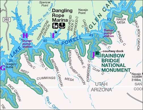
 The first point isn’t even on the lake. Horseshoe Bend (A) is a horseshoe-shaped curve in the river a few miles downstream from the dam. It’s often photographed from the viewpoint at the outside “top” of the bend, which you can walk to from a parking area right off Route 89. Here’s a photo I took today from the overlook.
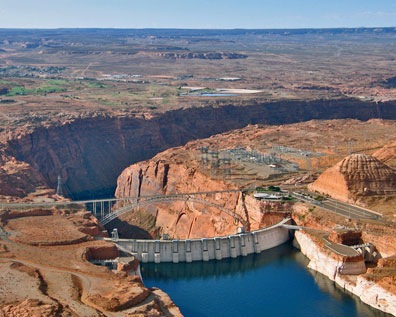
 The Glen Canyon Dam (B) is the dam that keeps all the water in the lake. It’s accompanied by a bridge a few hundred feet downstream that crosses Glen Canyon. From the air, you can get good views of both.
 Gregory Butte (G) stands out in my mind primarily because of its photogenic qualities. If you’re flying uplake early in the day and take a photo up Last Chance Canyon with Gregory Butte in the foreground…well, you get the photo you see here. It’s one of my favorite views of the lake. This shot was taken by my husband on one of our first helicopter trips to the lake together. The water level is a bit higher right now. If it rises some more, Gregory will become an island.
 Everyone wants to see Rainbow Bridge (J) from the air. Everyone, that is, except those who know better.
 I have a lot more to say about this day trip, but I can’t stop to write about it now. I’m terribly behind on a book project — partially because I took yesterday off — and I need to get the darn book done already.
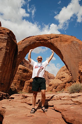
 Bob, who recently sent a photo of himself holding up the