Snowbirding 2017 Postcards: Grand Falls

The Grand Falls of the Little Colorado River is a waterfall that formed where the Little Colorado River cuts through layers of sandstone where that rock meets ancient lava flows. The fall are indeed “grand” — when the river is flowing. But more often than not, when I’ve flown over in the past, the water was just a trickle and the falls weren’t very Grand at all. 

Located about ten miles from pavement on a gravel road that switches from washboard to mud to the crushed volcanic rock used so often for road beds here and back to washboard more times than I can count, the Falls are within the Navajo Reservation in Northen Arizona. The are not easy to find without directions or the help of a GPS; there are no signs. GoogleMaps got me there and even then I almost missed the turn for the parking area. It was only because I knew what I what I was looking for — the shaded lookouts and pit toilet building — that I was able to navigate the final quarter mile and avoid Google’s misdirection.

The sky was overcast — I’d actually driven through thick fog for the first five or so miles from pavement — and the day was gray. But the Falls were flowing — no surprise considering the rain overnight — and putting on quite a show for the handful of intrepid tourists who had made their way to the site. Reddish brown water, heavy with silt, cascaded over the wide rock shelves, filling the air with thunderous sound. It’s no wonder the Grand Falls are nicknamed the “chocolate falls”; as one friend who saw the photo I posted on Facebook said, “It looks like chocolate milk.” 

I took photos from several angles, walking right up to the edge of the cliff more than a few times. These shots were from my iPhone and include a panorama image, but I also had my Nikon with me and made use of my 10-24mm lens to fit the whole Falls in. We stayed for about an hour. At one point, I thought the sun might break through — it was shining down canyon — but the clouds moved quickly to close the gap. It was just starting to rain when we left.

I need to note here that the Falls are a lot grander in the spring, when runoff fills the river with water. On those days, you can see mist rising from the Falls long before you reach them. Don’t be disappointed if you come and find them nearly dry.

Grand FallsGrand FallsGrand Falls

My Tree of Life

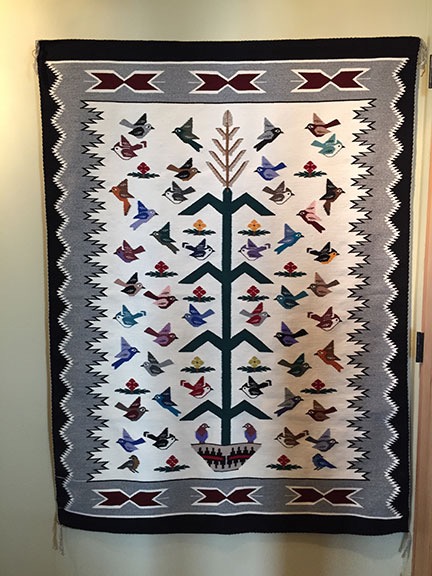
A Navajo rug with a story behind it.

One of my few prized possessions — indeed, one of the very first things I packed when I returned to Arizona in September 2012, expecting the quick divorce my wasband claimed he wanted — is my Navajo rug. This is the real deal, woven by a woman named Rena Mountain who lives on the Navajo Reservation at Cedar Ridge, AZ. Ms. Mountain is known for her pictorial rugs and seems to be an expert on the Tree of Life design.

Re-Hanging My Rug

I unpacked the rug about a week ago to show Kirk. I’d been thinking about it for a while, wondering where I could hang it, and I didn’t want to pull it out until I was ready. But I also wanted to show off this prized possession to someone I thought might appreciate its beauty. (I’m not sure how impressed Kirk was.) I knew that finding a place to hang it would take some thought.

One of the great things about my new home is the windows that line most of the walls. But those windows leave very little room to hang art. They also let in a lot of sunlight — much of it direct at certain times of the day and year — that can fade colors and cause sun damage. Where could I hang it where I’d enjoy its beauty while protecting it from direct sunlight?

And if you’re wondering why I don’t just put it on the floor — after all, it is a rug — you’ve probably never owned something so beautiful and relatively valuable. Simply said, this isn’t something I could imagine walking on. Ever.

I finally decided to hang it in the hallway across from the bathroom door. There’s a little stretch of hallway there and the walls of the hall perfectly frame the rug’s 45 x 60 inch size.

Back in Arizona, I’d hung it in the living room near the fireplace with velcro on a piece of wood that fastened directly to the wall with screws. I’d sewn the soft side of the wide velcro strip to the back of the rug using big, fat, easy-to-remove stitches. I’d stapled the rough side of the velcro strip to the wood using a staple gun. Then my wasband had drilled holes in the wood and, using molly bolts for extra support in the drywall, screwed the wood strip onto the wall. When I’d taken down the rug, I’d taken down the wood strip, too. I’d even, by some miracle, kept the molly bolts and screws. So I had everything I needed to re-hang it in my new home.

Tree of Life by Rena Mountain
My Navajo rug, hung in its new home.

I did this yesterday afternoon, using my stud finder to confirm that a stud was not available and a level to make sure I mounted the wood strip properly on the wall. The whole job, including fastening the rug to the wood strip, took just 10 minutes.

And it looks great. I can even reposition the track lights in the hallway to shine directly on it if I’d like to.

I posted this photo on Facebook when I was done. Almost immediately, my friend Jeremy asked for the story behind the rug.

How did he know there was a story? There is and it’s a pretty good one. I promised a blog post — this one — to tell it.

The Story behind the Rug

It was in September of 2000 or 2001. Or possibly 2002. I’d been living in Arizona for a few years. My writing career was building momentum and I’d finished my Quicken book, which ruined ever summer, a few weeks before. I had free time and was eager to get away for a while after working too many 12-hour days at my desk to get the book done on time.

I don’t remember who came up with the idea — it might have been me — but I decided to take a road trip with two friends to the Navajo Nation Fair in Window Rock. This is an annual event, like a county fair, but its held on the reservation and has a definite Navajo flavor, with lots of Navajo arts and crafts, food, and dancing. Along the way, we’d go exploring on the Reservation, visit the Hopi Reservation (which is completely surrounded by the Navajo Reservation), and do whatever struck our fancy. In other words, we make things up as we went along. I love traveling like that.

My two companions for the trip were Shorty and Martin.

Shorty was about 10-15 years older than me, a real cowgirl who spoke with a Texas drawl and had been married four or five times. She was short (hence the name), lean, and kind of gnarly, with skin browned and somewhat wrinkled from too much time in the sun. She was currently between husbands, living in her pickup camper in a friend’s yard, with her horse staying in a pen there. Over the two or more years we were friends, she’d move from place to place — even spending a few weeks camped out in my yard and housesitting for me — work at a local dude ranch, and train my rather difficult paint horse. I’d also be the maid of honor at her Las Vegas wedding — and that’s one hell of a crazy story — spend an evening catching Colorado River toads at an off the grid adobe house she lived in for a while, and dog sit for her three dogs while she went to England with what she hoped would be her next husband — another long story.

Martin was a young — maybe 35 years old? — good-looking guy from Germany. Like so many Europeans, he’d fallen in love with the west and dreamed of being a cowboy with a Fresian horse. (Not exactly a practical choice with all that hair to keep neat and brushed.) He was in the U.S. on a visa and was friends with the man who owned the local German restaurant. He tagged along with us, smoking whenever we stopped for a break. Shorty insisted on pronouncing his name mar-TEEN, claiming that it was the German pronunciation. Since he never corrected her, I got into the habit of doing the same.

The three of us headed north in my Jeep from Wickenburg, AZ. Martin sat in the back with the luggage in the tiny space behind him.

We pretty much bee-lined it up to the Hopi Reservation. Shorty wanted to send a friend a postcard from Old Orabi, which was founded back in 1100, making it one of the oldest continuously inhabited settlements within the United States. We got there and I don’t recall there being much to see. That has a lot to do with the simple fact that the Hopi people do not generally welcome visitors and many of them prefer to continue their traditional lifestyles. We walked around among a lot of seemingly deserted pueblo style homes — the Hopi are a Pueblo tribe — and then moved on to a Post Office where Shorty could mail her card. I’m pretty sure that was Hotevilla-Bacavi, also on Third Mesa.

The post office had a bulletin board and there was a card on it advertising fresh ground cornmeal. We found a payphone — back in those days, we didn’t all have cell phones — and called the number. We then got directions to a Hopi woman’s house nearby. We drove over and were welcomed in. The house was simple but modern, sparsely furnished but clean and comfortable. I clearly remember there being a bunch of kittens playing together in one of the rooms. The cornmeal, we were told, was leftover from a wedding ceremony. (Corn is an important crop to the Hopi people and plays a big role in their traditions.) It was stored in a big galvanized trashcan, lined with a plastic bag. The woman used a tin can to scoop out the cornmeal — did I mention that it was blue? — and put it into a Bluebird Flour bag (which I still have). Shorty paid for the cornmeal — I can’t remember how much, but it wasn’t much. The woman, likely seeing the opportunity of spreading tourist dollars to friends, told us about another woman who made dance shawls. Before you could say Kykotsmovi Village, we were off to another home. Shorty wound up buying two or three of the shawls. They weren’t my style, so I declined.

I totally enjoyed this side trip — cornmeal and dance shawls — because it gave me an opportunity to see the modern culture of these very private people.

Afterwards, we stopped by the Hopi Cultural Center, where I bought a “Grandmother” cradle Kachina, thus starting my limited Kachina collection. Our last stop in the Hopi land was Tsakurshovi, a native crafts shop in Shongopovi. That’s where I was introduced to Hopi Tea. I’d later come back to this wonderful shop several times to add to my Kachina collection.

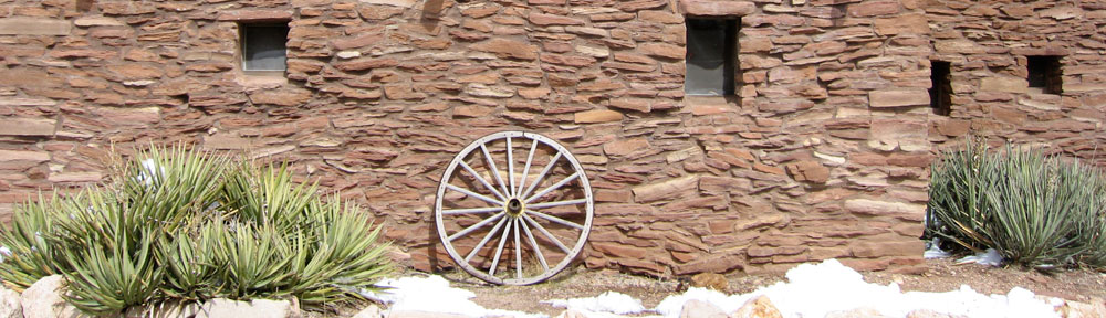
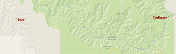
We continued on our way, leaving the Hopi Reservation and continuing through the Navajo Reservation. We stopped at the Hubbell Trading Post in Ganado, which is a National Historic Site and still a trading post. I wandered into the Rug Room and that’s when I saw it: the most beautiful rug I’d ever laid eyes on. Rena Mountain’s Tree of Life.

I fully admit that when I looked at the price tag I had a serious case of sticker shock. I’d never spent that kind of money on anything that couldn’t be driven or slept in.

I left the room and continued wandering around the Trading Post. But I kept thinking about it.

I wanted the rug. In fact, I don’t think I’ve ever wanted anything as utterly impractical as that rug as badly as I wanted that rug.

I grabbed Shorty and brought her into the room to see it. I was hoping she’d talk me out of buying it. But how could she? It was beautiful. And we both knew that I could afford it.

Yes, I could afford it. As I said earlier, my writing career was booming and I was bringing in more in royalties every year. I’d been investing in real estate and, in October 2000, bought my first helicopter. But my mind was stuck in budget mode and the idea of spending that kind of money on a rug I couldn’t even walk on was outrageous.

But I could afford it. And Shorty wasn’t going to talk me out of it.

So I got a sales person and brought her over to the rug. I timidly asked if they could do anything for me on the price. She cut it by $500. The next thing I knew, I was at the cash register with my American Express card out.

The cashier had to call American Express. They wanted to talk to me. I’d never spent this much on my card before and they wanted to make sure it was me.

The clerk folded up the rug and they put it in a plastic bag that looked remarkably like a garbage bag. I put it in the Jeep, way under the seat. For the next few days, I’d take it into the motel room at night and worry about someone stealing it out of the Jeep during the day.

We continued the trip. The Navajo Nation Fair was an amazing event. We saw more rugs on display — if I hadn’t already bought one, I would have bought one at the fair — ate mutton, saw traditional dancing and costumes, and watched the country’s only all-Indian rodeo, which was announced in both English and Navajo.

After two days of that — staying in a Gallup Hotel because Window Rock’s were booked — we headed out to Canyon de Chelly near Chinle, AZ. This is a National Monument with limited access. Because we had a 4WD vehicle, we hired a Navajo guide who rode with us in the Jeep and told us about what we were seeing. I loved the sound of his voice and the way he phrased things and repeated certain things in almost a sing-songy way. It was there that I learned about the brutality of Custer and his soldiers and got an idea of how mistreated Native Americans were in the 1800s. When I saw a point of interest — some rock formation — and asked him about it, he was strangely quiet. I asked him if there was some significance to the place that they didn’t share with visitors and he nodded. I asked him if there were many places in the canyon like that and he nodded again. I didn’t ask any more. I respect the culture and privacy of these people. Not everything needs to be a tourist attraction or photo opportunity.

I don’t remember getting into Monument Valley on that trip. I suspect we went home right after Canyon de Chelly. I do recall exploring a road back near Tuba City with views down from a mesa top and seeing petroglyphs that weren’t on any map. Real exploring — not following tourist guidebooks — that’s how I like to travel.

Certificate of Authenticity
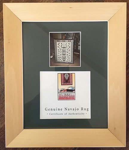
The Certificate of Authenticity, with a photo of the weaver, hung beside the rug for years.

I got home with the rug and, with my wasband’s assistance, hung it on the wall as described above. I took the tag, which featured a photo of Ms. Mountain holding up the rug, and asked my friend Janet’s partner to mat and frame it for me. It hung on the wall beside the rug. (I just spent about 30 minutes looking for a photo of how they hung together but can’t find one — all the photos I have of my house’s interior are either of damage/neglect by my wasband while I was in Washington or after I’d begun packing. As I mentioned earlier, the rug was one of the first things to be packed.)

Postscript

Time marched on. Although that was one of the most memorable trips of my life, it was not to be repeated. Shorty married Martin to keep him from getting booted out of the country. I was maid of honor/witness at the crazy Las Vegas wedding. Later, Shorty met her “soulmate,” a retiree from Britain who stayed at the dude ranch where she worked. Their courtship lasted a few months, during which time I assume she and Martin were divorced. But the wedding plans fell through and it wasn’t long before both she and Martin fell out of my life.

I went back to the Navajo Nation Fair the following year. It was a non-event. The Navajo young people were wearing the same falling-down pants as the rest of the brain-dead youth in our country and much of the charm I’d experienced the year before was gone. You know what they say: you can never go back. This is a perfect example.

But the rug remains and now it hangs in my new home to be part of my new life.

I’m glad to have it and the memories that go with it.

Stirring Emotions with Misleading Headlines and Photos

I’m sick of people sharing misleading information on social media.

The other day, one of my Facebook friends posted a link to an online petition on a site called Sum of Us. I won’t share the link, but here’s the top of the page:

Petition
This petition’s page is over the top when it comes to using misleading information to stir emotions.

When I saw the image at the top of the page, my immediate reaction was, “The Havasupai are building a mall?”

You see, the photo shows Havasu Falls, which is just down Havasu Creek from Supai, a tiny village on the Havasupai reservation inside the Grand Canyon. Supai is so remote that you can only get there three ways: on foot, by horse/mule, or by helicopter. There are no roads leading down to Supai. Because of this, it gets relatively few visitors — perhaps a 100 a day during peak summer tourism months. It’s widely known for it beautiful blue waters, waterfalls, and travertine rock formations. I’ve been down there three times and feel very privileged.

The idea of Supai having a “super mall” is absurd, so I clicked through to see what it was all about.

Apparently, I’m the only one seeing this post on Facebook who doubted the veracity of the headline/photo combination. Most of the people who saw it shared comments voicing their outrage that such a beautiful place should be ruined and assured the rest of us that they’d signed the petition.

Of course, the real story didn’t have anything to do with the Havasupai land in the Grand Canyon — which, by the way, is outside park boundaries. It was about the Navajo land on the east side of the Grand Canyon and a proposal to build a tourist attraction near the confluence of the Little Colorado River and Colorado River. These two sites are a full 50 miles apart as the crow flies.

Locations
The beautiful waterfall in the photo is 50 miles away from the actual confluence of the two rivers. On this map, green represents actual park land.

The leading paragraph spread more misleading information; they added the emphasis, not me:

Property developers want to build a super-mall smack dab in the middle of one of America’s most breath-taking world heritage sites, the Grand Canyon. The mall would include an IMAX, shops, hotels and fast food cafes. The National Park Service has called the plans ‘a travesty’.

I don’t know about you, but “smack, dab in the middle” should be somewhere near the middle of something — not on the far east end of it. As the map above shows, this development won’t be anywhere near the middle of the Grand Canyon. The Grand Canyon is mind-bogglingly huge: 1.2 million acres or 1,904 square miles — that’s bigger than the entire state of Rhode Island. A development at the Confluence won’t be visible from the South Rim, which hosts at least 90% of the park’s visitors — many of whom spend less than an hour looking at the canyon — or the North Rim.

Grand Canyon Map
Here’s the big picture. Grand Canyon National Park is pink; Native American reservations are purple. You can download the whole map as a PDF. Note that there is a dispute over the exact location of the border between park and Navajo lands that would affect the ability of developers to move forward.

The truth about this story is that developers want to build a tourist attraction on the rim of the Grand Canyon inside the Navajo reservation. It would include shops, hotels, and a tram to the bottom of the canyon so people could actually access a part of the canyon that’s currently limited to hearty hikers, river runners, and mule riders — a tiny fraction of the park’s visitors. This isn’t too different from what the Hualapai have done on the west end with their Grand Canyon Skywalk or what the Navajo have done in Monument Valley with The View Hotel.

And maybe I should remind people that National Park Service concessionaires already manage six hotels (El Tovar Hotel, Bright Angel Lodge, Maswick Lodge, Yavapai Lodge, Katchina Lodge, and Grand Canyon Lodge) and well over a dozen gift shops on the rim of the Grand Canyon, inside the park. And a hotel at the bottom of the Grand Canyon (Phantom Ranch).

So what this petition page has done is used a photo of a beautiful waterfall that was shot 50 miles away, coupled it with a headline referring to a super mall, and led with an untrue statement regarding development in the middle of the Grand Canyon. Someone who doesn’t know the facts and relies on the information on this page might think there’s going to be a giant mall ruining the vistas at one of the world’s natural wonders.

So people sign. They provide their names and email addresses. Those addresses are likely harvested for use in other slactivism efforts. They’re likely followed up with pleas for donations to support the cause.

And people share the link to the misleading information, getting their friends to sign up, too.

And people talk about the “problem,” using the misleading information they read — if they bothered to get past the photo and first paragraph.

And this pisses me off to no end.

Now please don’t think that I’m in favor of more development at the Grand Canyon. I’m not. But I am in favor of Native American people being able to develop their land in ways that economically benefit them. I’m very familiar with the Navajo people, having spent quite a bit of time on and over the reservation. There are social problems including poverty, obesity (and related health issues), and alcohol abuse. Young people are leaving the reservation for better opportunities elsewhere. The native language — which was instrumental in our World War II communication efforts — and culture are being lost. If the Navajo people vote in favor of a project like this on their own land, I don’t see any reason why we should stop them. It would give them jobs, bring more tourists and tourism dollars to their part of the canyon, and help their economy.

Again, the Hualapai did this at Grand Canyon West and no one seemed to care. Why care about this now?

Oh, yeah. “Smack dab in the middle.”

My advice to people reading petitions like this: get informed before you let the authors manipulate your emotions to get the response they want. Don’t share misleading information.

We all know how difficult it is to find the truth on the Internet — and the problem is getting worse every day. Don’t be part of the problem. Don’t share information unless you know it’s accurate.

Homeless in Page, AZ

A true story.

“Can you help me…with some food?”

The query came from a Navajo woman with a cane in the Safeway supermarket parking lot in Page, AZ. I was just walking up to my rental car when she came up to me.

I thought for only a moment. “Sure. What would you like?”

“Taco Bell.”

The Taco Bell was just down the street. “I’ll take you there,” I told her. “Hop in.”

She walked around to the other side of the car while I climbed in my side. I put my Starbucks latte in the cup holder and tossed the lemon coffee cake I’d bought onto the dashboard. I had some things on the passenger seat and moved them for her. Then she climbed in, putting her cane between her legs and shut the door. She was conservatively dressed, looked clean, and didn’t appear (or smell) drunk. She had a round face with flattened features and half-opened eyelids. She looked almost Asian. I remembered that the Navajo were descended from the people who had crossed the Bering Strait into North America in prehistoric times. She looked to be in her sixties.

I started toward Taco Bell. It was 9:40 AM. “It’s not even 10 o’clock. Do you think it’s open?” I asked.

“No. I don’t think so,” she replied thoughtfully. “It’s open until 11 at night.”

“How about McDonald’s?” I suggested. “They make a good breakfast.”

“Okay.”

McDonalds was down off the mesa on Route 89, about 2 miles away. I started down the hill.

“Do you work for a hotel?” she asked me. She’d obviously seen my rack cards, which I’d be bringing to the airport the next day.

“No,” I replied. “I work for a tour company.”

“Where are you from?”

“The Phoenix area,” I told her. “Wickenburg.”

“Oh, I know Wickenburg,” she replied. “I used to live in Glendale. Peoria, El Mirage.” She thought for little while and added, “I moved there when my husband died. Now I’m just homeless.”

I steered us down the hill. Lake Powell and the Glen Canyon Dam came into view.

“Can’t they help you at the Chapter House?” I asked. It didn’t seem right that the Navajo people would let one of their own remain homeless on the streets of Page.

“No, they can’t help me.”

The conversation died as we rolled down the hill. I suspected she wasn’t telling me everything. She was too clean and well kept to be truly homeless. She must be going somewhere at night.

“Do you have family in Page?” I asked her as I made the left turn onto Route 89.

“I have a son in Salt Lake City and another one in Phoenix,” she replied.

The conversation died again. This time she revived it.

“I heard that Chinatown got wiped out.”

I made her repeat what she said; I didn’t think I’d heard it right the first time. But I had.

“Chinatown?” I repeated. There was no Chinatown within 500 miles of Page, AZ. “I don’t know what you mean.”

“I heard it on the news.”

It came to me suddenly. “Oh, you mean Japan. The earthquake and tsunami.”

“Yeah, that’s it.”

By this time, McDonald’s was in sight.

“Can we go to Burger King instead?” she asked.

I saw the Burger King logo just up ahead. “Sure. You like that better?”

“Yes. They have a good deal. Two hamburgers for three dollars.”

I pulled up to the drive through at Burger King. The menu was on a board beside the talking box. “What do you want?”

“Two hamburgers,” she said. I think she was trying to save me money.

“Some orange juice to go with that?” I asked. I was thinking about getting something healthy into her.

“Yeah.”

“Anything else? Some fries?”

“No fries.” She was reading the menu board. “Maybe the sausage, egg, and biscuit,” she said suddenly.

“Okay. And two hamburgers for later?”

“Yeah.”

After what seemed like eternity, a voice came through the speaker. I ordered the sausage, egg, and biscuit breakfast meal and two hamburgers. The order taker asked if I wanted coffee or orange juice with that. I asked my companion.

“Orange juice.”

The order taker read back our order. It came to seven dollars and change. She told us to pull up to the second window.

At the window, the order taker took my money and gave us the orange juice and a straw. Then she asked us to pull up and wait in the parking lot while they made the burgers. Because it was so early, they’d have to be made special. So I pulled around to the parking lot.

While we were waiting there, I asked, “Why did you come back here from Phoenix?”

“I wanted to come back to my reservation,” she said. After a while, she added, “My mother and father live here.”

“Do they live far from Page?”

“Yes. Very far. Thirty-six miles. You go down Haul Road and then you keep going.” She added the name of the town but I didn’t catch it. Later, I found Kaibito on Route 98 36.9 miles from Page in the right general direction.

“Maybe you should go live with them for a while,” I suggested.

“I been thinking about it.”

“I think it’s a good idea,” I said honestly. I hesitated, then asked: “Do you need someone to drive you there?” I would have done it to get her off the street. My morning was wide open.

“No,” she replied. “I can hitchhike.”

I knew that hitchhiking was a popular means of transportation among Navajo people on the Reservation. I’d picked up a hitchhiker once myself, when I was driving through the Rez with some friends. She’d be okay.

The order taker came out with her food and I handed it over. I backed out of my parking space and prepared to take her back up into town.

“Can you drop me off at McDonald’s?” she asked.

McDonalds was just down the road, near the Wal-Mart. “Sure.” I drove over and made the turn. “Where? Here or near Wal-Mart?”

“Here,” she said. “By the tables.” McDonald’s had some outdoor tables in the sun. “I can sit and eat here.”

“Okay.” I drove over to the tables and stopped. For a moment, she struggled with her bag of food, orange juice, and cane. Then she managed to get the door open.

“Do you think you can help me with some money?”

I was wondering if she’d ask and was prepared. I handed her a $10 bill. “Here you go. Use it to get something good for yourself.” I still wasn’t convinced that she didn’t have a drinking problem — alcohol is a major problem on the Rez. But I couldn’t say no. I have so much; she had to ask strangers for food.

She took the money. “Thank you.”

She got out of the car, closed the door, and stood still behind it. I shifted into drive and pulled away slowly. When I’d gone around the McDonald’s to the exit, I saw her sitting at the table with her breakfast and lunch.

I drove back to my hotel, just down the road.

Phoenix to Lake Powell by Helicopter

Again, but this time with video.

The initial call about the January photo gig at Lake Powell came in December through one of my Russian connections. Apparently, two Russian businessmen who were attending the Consumer Electronics Show (CES) in Las Vegas wanted to photograph the Lake Powell area from the air. They were willing to pay me to fly up to Lake Powell from Phoenix and make at least two flights totaling 3 to 5 hours.

Trips like this are extremely costly — after all, the client has to pay for 4 hours of flight time just to get me up there and back — and I honestly didn’t expect it to happen. But a week before the chosen dates — January 12-13 — I got the green light and the all-important credit card number I needed to get paid for that 4 hour repositioning flight plus a standard overnight fee to cover my expenses and compensate me for my time away from home.

The Gig

Weight and BalanceI admit I wasn’t looking forward to the gig. The two photographers claimed to weigh 242 pounds (converted from kilos) and I knew they likely weighed more fully dressed and carrying camera equipment. I calculated the weight and balance as soon as I had this information and discovered that I’d have to strip all non-essential equipment out of the helicopter to lighten it up so we could take enough fuel for 2 hour flight segments (plus FAA-required reserves). Anything that was left on board would have to be shifted from under my seat to under the seat behind me, just to shift weight backwards. Having two fatties — yes, including me — up front would make us front-heavy. Having two fatties on the left side would make us heavy on that side. But even after adding 15 pounds of weight for each of them, I confirmed that’d be in balance with 2/3 fuel or less on board.

The other thing that bothered me was weather. Page, AZ was having unseasonably cold weather with daytime highs barely getting above freezing. Flying a helicopter with two doors off guarantees plenty of outside air inside the cabin and no amount of heat is going to win against 30°F outside air. So not only did I have a bit of a challenge ahead of me with a listing (but still within acceptable CG) aircraft to fly, I’d likely be freezing my ass off.

As far as the helicopter goes, I wasn’t worried about the cold weather affecting operations. My R44 Raven II is fuel injected, so carburetor ice is not an issue. I’d flown it in cold weather before and it was always peppy — once I got it started. In fact, that was my only real concern: Lake Powell photographers usually want to get off the ground at dawn for morning flights and with overnight temperatures under 20°F, I worried a bit about getting the helicopter started for its morning flight.

But the gig did have one big thing going for it: at least 4 hours of revenue time. And if there’s one thing I’m interested in, it’s getting paid to fly.

The Flight Up

Lake Powell is about 200 nautical miles north of the Phoenix area. Since my clients were paying for a 2-hour flight, my goal was to make it there in two hours. That meant flying as close to a straight line as I could.

CourseUsing Sky Vector, I plotted a course from Phoenix Deer Valley Airport (KDVT) to Page Municipal Airport (KPGA) with only one waypoint in between: the Little Colorado River Gorge (LCRG) on the east side of Grand Canyon’s Special Use Airspace. I wrote down the coordinates for the LCRG to punch them into my GPS — a recent GPS battery change had wiped my user waypoint list clean. The flight path would take me north along the east side of I-17, crossing it just before it dips down to Camp Verde. I’d cut across the Verde Valley between Sedona and Cottonwood, then climb the Mogollon Rim west of Sedona, pass east of the restricted area for the Navajo Army Depot, west of Flagstaff, and west of the San Francisco Peaks, the tallest mountain in Arizona. From there, I’d drop back down into the Navajo Reservation, flying over its western edge, hop the Echo Cliffs, and drop back down to Page, AZ.

And that’s mostly how it all came off.

I departed Deer Valley at about 8:45 AM under partly cloudy skies with little or no wind. It was a cool morning, with temperatures just climbing through the 50s. I crossed Deer Valley’s runways at 2000 feet MSL as required by the Tower there and got right on course, aiming for the LCRG waypoint I’d added to my GPS.

It was interesting and different to fly a straight line route through an area I knew so well. After all, I’ve been flying from the Phoenix area to Sedona, the Grand Canyon, Flagstaff, and Lake Powell for years, so it’s not as if the area I’d be flying over was new to me. But I usually fly with passengers on board and, to make the flight more interesting, I fly over or past various points of interest, such as towns, highways, mine sites, and canyons. On this flight, speed was the goal — I wasn’t interested in scenery. But I got scenery anyway — how can you fly a helicopter through Arizona without seeing something spectacular every mile?

As I flew, my GoPro Hero camera recorded a 720p widescreen video of the flight. Mounted up front, it offered an unobstructed view of everything ahead of me. The wide angle lens brought in details of what was close while pushing back distant points. Later that night, I’d watch much of the 2 hours of video and remember the various points of the flight.

Mountains north of PhoenixWhat fascinated me was the way the light changed throughout the flight. At first, it was partly cloudy. Then the sun slipped behind the clouds and it was cloudy. Then the sun began to break through, speckling the mountainsides with light. This still image, captured from the video, gives you an idea of what I mean. The light changed numerous times over the two-hour period of the flight — at one point, clouding over completely only 1,000 feet above me — giving the illusion that the flight was conducted over multiple days.

It wasn’t just the light that changed, of course. It was also the terrain. Flat desert in the Phoenix area, soft mountains studded with saguaro cacti as I headed north, flat mesas with steep basalt sides, deeply carved canyons, wide valleys, red rock cliffs and hoodoos, alpine forests blanketed with snow, tall mountains, ancient cinder cones, flat “painted” desert, deep gorges, buttes, uplifted cliff faces, slot canyons. I saw it all over the course of my two hour flight — all without trying to see it. My nearly straight line course simply put me over the top of all these things. I sat comfortable and warm in my seat, admiring the view as I glided over it.

Glided is definitely a good word. There was hardly a breath of wind during the entire flight so it was amazingly smooth. A pilot’s dream. And although outside temperatures dipped as low as -5°C, I was cosy and warm with the heat up only about halfway.

SedonaOne of the highlights of the flight was crossing the red rock cliffs west of Sedona and climbing up over the Mogollon Rim. The light was absolutely perfect, breaking through light scattered clouds to illuminate the rocks with a soft golden light. Absolutely breathtaking and the GoPro camera captured the whole thing.

Beyond that was a surprising amount of snow and a light overcast layer that shrouded the top of the San Francisco Peaks. The temperature there was around 0°C, but the Flagstaff ATIS reported -5°C — a real thermal inversion only 10 miles east. The low cloud layer and dimly lighted snowfields made me feel claustrophobic. Ahead of me, it looked as if some precipitation could be falling from the clouds. That got me a bit worried about icing, but I continued on. By the time I got to the point I thought I’d seen rain or snow falling, it had stopped — and so did my worries.

The only surprise on my flight was upon reaching the GPS coordinates for the LCRG. Simply said: it wasn’t there. It was about 10 miles northwest of where I’d plotted it to be. I can only assume that I’d punched in a wrong digit when I entered the waypoint into my helicopter’s GPS. So rather than fly over its most dramatic point, I crossed a bit to the east and kept going. I deleted that waypoint so I wouldn’t depend on it again. Oddly if I’d made a serious mistake in the entry, I would have noticed it a lot sooner. But because it was only off by a little bit, it wasn’t until I passed the waypoint that I realized the error. I’ll definitely be more careful in the future.

Over the RezWhen I got to the empty expanse of the Navajo Reservation, I dropped down and flew low over the ground. There were few homes in the hundreds of square miles and only a handful showed signs of life. In the video, my helicopter’s shadow is clearly visible: small when I’m flying higher and larger when I’m flying lower. The video makes it seem as if I’m going much faster during this portion of the flight, but I’m not. I managed to keep a steady 100-110 ground speed for most of the flight. It’s just an illusion: the closer the camera is to the ground, the faster I seem to be flying.

I crossed over the Echo Cliffs at Cedar Ridge — at least I think that’s where I was — and sped across more of the Navajo Reservation north. In all, I think about 45 minutes of the flight was spent over the Rez. It’s an amazing land of stark beauty, sprinkled with traditional homesteads, more modern yet simple homes, and, on its far western reaches, the ruins of abandoned homesites clearly visible as rock rings and corrals. The traditional Navajo home is a round or octagonal building called a hogan and they are clearly visible from the air. Also visible on most days are livestock such as cattle and sheep and wild horses.

I descended down toward the lake, flying at a low enough level that I didn’t actually see its clear blue water until I was about 15 miles out. Of course, I could see other landmarks — notably the bulk of Navajo Mountain about 50 miles to the east of Page and the Navajo Power Plant, with tall stacks belching ugly smoke into the air just outside of town. The radio frequency was silent as I descended toward the airport. I lined up with the taxiway and set down on one of the helipads.

The Video

Later, after doing 3.4 hours of photo flying around the lake and points east, I watched the video shot by my GoPro Hero. It was probably some of the best footage I’d ever captured with the camera. My only regret was that I hadn’t shot in in 1080p.

Over the course of two days, I assembled a movie from seven-second clips shot during that two hour flight. Last night I added titles and music. I exported it for my iPad and uploaded it to YouTube. Here it is. Enjoy.