
One of those days when you wish there was a “do-over” button.
Yesterday wasn’t an especially good day as far as productivity is concerned.
Shooting Trouble
I started the day with a computer problem. Simply said, I was locked out of all my blogs. It was impossible for me to download entries into ecto (which is how I first discovered the problem) and impossible to make any changes to my blogs.
The error message I got said my IP address was blacklisted.
I spent the next 3 hours troubleshooting the problem, with calls and e-mails to my Internet connection ISP, my Web host ISP, the maker of ecto, and one of the blacklist maintenance company. The cause of the problem turned out to be a change in the server used by one of my plugins, Bad Behavior. When I upgraded all my blogs to Bad Behavior 2.0.11, the problem went away. I wrote about it in Maria’s Guides, since I suspect there were many Bad Behavior users in the same situation yesterday morning.
But that was 3 hours wasted.
Costco Visit
Next, I was scheduled to attend a 2-hour seminar given by SCORE’s Phoenix Chapter. The seminar was in the Phoenix area, so I had to make a 40-mile drive to get there. I jumped in the shower, washed up, got dressed, and even put some makeup on. Then Ihopped in my little Honda and took off down Grand Avenue, stopping only long enough to pick up some “breakfast” at Filibertos — a pollo asado buritto. It was 10:30 AM.
I needed to hit Costco, near Bell Road and the Loop 101. I’m putting together care packages for U.S. troops deployed in the Gulf area and have 8 more packages to put together to meet my self-imposed quota of 10. Since the kinds of things these men and women were looking for were snacks and toiletries best bought in bulk, I figured Costco would be a good place to shop and perhaps save a few bucks.
When I got to Costco, I realized that I not only didn’t have my Costco membership card, but I also didn’t have my driver’s license for ID. I didn’t want to drive back the next day, so I tried to get some kind of temporary pass so I could shop. I was able to do so, but with the line I had to wait on at the membership desk and the amount of time they took to look up my husband’s business account, I was soon out of time for shopping. I needed to get to the seminar.
Girlfriends Helping Girlfriends
The SCORE event was held at the very nice Glendale Aquatic and Recreation Center. I guess having a facility like this is one of the perks of living in a place where more than 50% of the population is under the age of 65. It was a big meeting facility attached to an indoor pool. I assume that there were other facilities in there for recreation, but I didn’t wander around. I checked in and went right inside.
For some reason, I thought my seat at one of the two dozen round tables was in the back corner of the room. It turned out to be in the front corner. I soon got into a conversation with another female business owner, Marcy, who sells electrical components for commercial construction.
I should mention here that the topic of this free seminar was “Women Helping Women.” Four “successful” business women would each give a 10-minute presentation. Afterward, they’d sit together on a panel where one of the women acted as a moderator to ask them questions. We were supposed to be able to ask them questions, too, but that never happened.
I won’t go into detail on the speakers. I will say that the first one, a “self-made woman,” was primarily a motivational speaker with a big booming voice and a “you can do it” attitude and message. I agree with that entirely, although she was a little too self-promotional for my taste. The next few simply couldn’t compete, with their relatively tiny voices, flat stories, and failed attempts at humor. They should have ended with the big woman. It would have done more to keep us awake than the Hershey’s kisses they put in front of us. (My sugar buzz hit just after the last speaker.)
They talked about networking and helping your “girlfriends.” This is an attitude I just can’t tolerate — pointedly making a distinction between men and women in the workplace and going out of your way to help one gender over the other. I’m of the school that says if you can’t make it in a field, get out and make room for someone else. (This could be a result of working in the highly competitive New York job market, where I had my first career.) I don’t care if you’re a man or a woman. If you can do it, do it. If you can’t, don’t expect help just because you pee sitting down. In fact, I think the attitude of women insinuating that they’re different and need help is part of what keeps them from achieving what they could achieve. They’re holding themselves back with gender-related excuses.
Which may make you wonder what I was doing there. Frankly, as the third speaker started on her “help your girlfriends” spiel, I was wondering that myself.
Time crawled. By the time they were finished, I was ready to go. While the other women “networked,” I bolted.
Back to Costco
This was probably the only productive part of my day. I spent nearly an hour in Costco, gathering up snacks, toiletries, and a few personal clothing items to send the troops. I also bought a case of my current favorite wine, a king-sized bottle of Ketel One, some Pine Sol, flannel sheets for our camper, and two pairs of men’s lounge pants, for me to wear to work in my home office.
I won’t say how much I spent. I will say that I spent too much.
These things filled my car’s trunk. I had to put the case of wine on the front passenger seat.
The Wasted Meeting
By then, it was 4 PM and I still had one stop to make: at the helicopter flight school where I’m planning to get my instrument rating. I called to make sure they were still open and expecting me. They were and they were. I told my contact I’d be there within 30 minutes and hit the road.
I made it in 20 minutes. I went into an office filled almost to overflowing with men in tan flight suits. I found the one I was looking for and he brought me into the new Chief Pilot’s office.
I saw “new” because the organization had undergone a major shakeup less than two weeks before. The man I’d negotiated pricing, etc. with was gone. His replacement was a small, young man who was evidently enjoying his position of power. He produced the rate document that had been drawn up by his predecessor for me. He said that with the other guy gone, I’d have to meet with his boss to verify the rates. His boss worked at Mesa, where I get my helicopter maintained. He’d sent me to Glendale for training, since it was closer to where I lived. But he was in Las Vegas right now, so we couldn’t call him. We’d have the meeting on the next day.
He didn’t seem to give a shit that I’d driven down from Wickenburg — a distance of about 50 miles — for the meeting and that I might have to drive down again for another meeting the next day. I held my temper. It wasn’t easy. I don’t like having my time wasted, especially at the end of a long, frustrating day with a long drive ahead of me.
They wouldn’t even put me in the system or get me on the schedule. The meeting was a complete waste of time.
And I know what’s coming. They’re going to try to go back on the rates we tentatively agreed upon. I suspect that they’ll raise them by about $20 to $50 per hour. Since I need 30 hours, this will make my instrument rating even more costly than the $8K I’d budgeted for it.
I’m already thinking about looking for another flight school. The only problem is, all the flight schools in Arizona — including this one — use the “program” approach: pay one price and get all your ratings and the pseudo promise of a job. I was lucky to find this place so “close” to home. That means I might need to go out of state — which would be more costly — at my busiest flying time of the year if I want the rating by spring. So I’m in a pickle.
But what bothered me most is attending a meeting for no reason other than to tell me that I’d have to attend another meeting. Hell, isn’t that what a telephone is for? Why the hell do people think I wear that damn thing on my belt?
The Drive Home
It took an hour to get home from there. I went west on Glendale Road, then drove around Luke Air Force Base. I got to see some F-16s landing right over my head. (I had the top down.) Then I took route 303 back up to Grand Avenue.
Along the way, I took a phone call from a guy in Montana. A friend of his had flown with me on a tour and told him I might be a good contact for information about R-44 helicopters. I answered his questions. He wants the helicopter to commute back and forth to work, which is about 60 air miles each way. I told him to think of me if he needed a ferry pilot to bring the aircraft from the factory to Montana. That’s a flight I’d love to make.
The drive was nearly traffic-free once I got on Route 303. Between podcasts on my iPod and the telephone conversation, I was kept entertained. So it really wasn’t so bad. I suppose I should get used to it if I’m going to get flight training at Glendale.
It was nearly dark when I got home at about 6 PM. Mike was already home, feeding the horses. As I made dinner, I kept thinking about how much precious time had been wasted that day.
 Sitting on our hilltop, we were treated to a beautiful sunset, just before the second storm rolled in.
 I played a bit with my new camera and managed to get some outstanding lightning shots by placing my camera on a snack table with its lens propped up, setting it to shutter speed priority, and setting the shutter speed to 30 seconds. I pushed the shutter release by hand and waited. 15 of the 20 shots I took included lightning. I think this one is the best.
 On our way home, we had a bit of an off-pavement adventure, driving out to Sycamore Point, which overlooks Sycamore Canyon, west of Sedona. The road is usually passable by any vehicle, but it was pretty muddy yesterday and a storm passed though while we where there. There was a great view of the canyon, which is a wilderness area and off-limits to motor vehicles. The light wasn’t favorable for photography, but I took a few shots anyway.
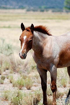 Just past Peeple’s Valley, we stopped for a while to photograph a herd of semi-wild horses. The horses are owned by the Maughan Ranch folks, who turn them out into a 40- to 80 acre pasture. While out there, the mares and the stallions get together. Eleven months later, there are foals. The foals have never been handled by people and are about as close to wild horses as you can get in a fenced-in area. There were about 40 horses out there when we stopped and at least a dozen of them were babies, not much more than 6 months old.
 I wanted to photograph horses in a natural setting, with desert mountains in the distance. But being the time of day it was — nap-time for a horse — they just stood around half asleep on their feet. The babies were curious about us and one, whose mother actually came up to the fence to say hello and get an ear rub, came close enough to touch. But, in general, it wasn’t the scene I was thinking about for photos. The 20 or so shots I took with various lenses were very disappointing. These shots, however, can give you a pretty good idea of the scene.
 The first windmill, the Orofino Windmill, was a non-functioning relic. Its blades were badly damaged, the bar from the windmill to the pump was half gone, and its vane was damaged by shotgun fire. It stood nearly motionless, like an aging sentinel for the empty cattle pens and dry water tanks around it. Beyond it, the monsoon season clouds blossomed and drifted in the otherwise blue sky. Just before we left, a breeze blew the vane, rewarding me with a satisfying squeal as the windmill’s head shifted 10° to the left.
 The next windmill, which was on the right, was in better condition and still functioning. It has no name on my map, but lies at the intersection of our dirt road with a much less-used road. There was a young black cow standing at the concrete water tank when we pulled up, but as soon as we opened the Jeep’s doors, it fled and we didn’t see it again. The windmill spun lazily in the breeze, not making a sound. It was obviously well greased and well cared-for.
 We were probably on that road for at least 45 minutes, always climbing. There wasn’t anything interesting along the way, although there were one or two spots where we could get a view back toward the river. After a particularly narrow spot, we emerged at the top of the ridge where the road we were on intersected with another dirt road, labeled 667 on my map. We turned left, then stopped to consult the GPS map. The photo you see here is looking back toward the road we’d come up on (on the right) and the road we were now on (to the left).
 The vegetation all around us was mostly holly and manzanita. The manzanita have dark red bark and small leaves. It’s a hard wood and is commonly used for perches in parrot bird cages because even hookbills have a hard time chewing through it. Although the bark is normally very smooth, I did find a bunch of trees with peeled, curling bark. There were also some pines, although I didn’t pay attention to what kind. Probably juniper — they were short like the rest of the bushes.
 Although the road we were on curved to the left where it would dead-end just past the remains of the Jersey Lily mine, we turned right onto road 97B, which continued climbing up into the mountains. We made a brief stop at the site of the Big Chief Mine. The access road had long been overgrown with bushes and weeds, but we made our way forward on foot for a few hundred feet. Off to the right, on the side of a hill, we spotted the remains of an old wooden shack. The path to reach it was overgrown and we didn’t dare attempt it in shorts.
 Finally, when it seemed as if we’d reach more well-traveled roads soon, Mike agreed to stop for lunch. It was 1:30 PM. Although it was still raining, we found a spot under a juniper tree where we settled down on the ground and opened the cooler. We don’t picnic with sandwiches, like a lot of people do. We picnic with deli department treats. That day, it was fresh mozzarella “medallions,” thinly sliced prosciutto, marinated whole artichoke hearts, green olives with garlic, and dry salami. Yum. While we ate, we watched the weather all around us. I took this photo of the area to the north; you can see the rain coming down in the vicinity of downtown Prescott, just beyond the hills.


 It’s Friday morning and, as usual, I was up at about 5:30 AM. Our hotel is weird. It was probably an old hotel that was recently gutted and renovated. Our room has nice (fake) hardwood floors, clean white walls, and a king-sized bed. But not much else. Really. There’s no dresser, no chairs (other than on the little balcony), no table, no sofa. There are two night tables and one lamp. No clock. The TV is a 17 or 19 inch flat screen, mounted on the wall. There’s a 3 cubic foot refrigerator and a wire clothes rack on wheels as a closet. The place is trying to be “trendy minimalistic,” and although the effect is pleasant, it isn’t comfortable. We have views of the ocean from our windows, but no access to the beach. And the two lanes (in each direction) of the Pacific Coast Highway run right past the place. Cars, trucks, and motorcycles drive by throughout the day and night.