Getting Even Closer

I take (and pass) my Part 135 check ride

I spent most of yesterday with an FAA inspector named Bill. Bill is my POI for Part 135 operations. Frankly, I can’t remember what those letters stand for. But what they mean is that he’s my main man at the FAA in all Part 135 matters.

Yesterday was the second day this week I spent time with Bill. On Wednesday, I’d gone down to Scottsdale (again) to set up my Operating Specifications document on the FAA’s computer system. The FAA has been using this system for years for the airlines and decided to make it mandatory for the smaller operators, including Part 135 operators like me. Rather than put me on the old system and convert me over to the new one, they just set me up on the new one. That’s what we did Wednesday. It took about two hours that morning. Then Bill and I spend another hour reviewing my Statement of Compliance, which still needed a little work, and my MEL, which needed a lot of work.

I had lunch with Paul, my very first flight instructor, and headed back up to Wickenburg, stopping at a mall in a vain attempt to purchase a quality handbag. (Too much junk in stores these days, but I’ll whine about that in another entry.) I stopped at my office and my hangar to pick up a few things, then went home. By 4:00 PM, I was washing Alex the Bird’s cage and my car. (I figured that if I had the hose out for one, I may as well use it on both.) After dinner with Mike, I hit the keyboard to update my Statement of Compliance so it would be ready for Bill in the morning. I added about eight pages in four hours.

A word here about the Statement of Compliance. This required document explains, in detail, how my company, Flying M Air, LLC, will comply with all of the requirements of FARs part 119 and 135. In order to write this, I had to read every single paragraph in each of those parts, make a heading for it, and write up how I’d comply or, if it didn’t apply to my operation, why it didn’t apply. (I wrote “Not applicable: Flying M Air, LLC does not operate multi-engine aircraft” or “Not applicable: Flying M Air, LLC does not provide scheduled service under Part 121” more times than I’d like to count.) Wednesday evening was my third pass at the document. In each revision, I’d been asked to add more detail. So the document kept getting fatter and fatter. Obviously, writing a document like this isn’t a big deal for me — I write for a living. But I could imagine some people really struggling. And it does take time, something that is extremely precious to me.

I was pretty sure my appointment with Bill was for 10:00 AM yesterday. But I figured I’d better be at the hangar at 9:00 AM, just in case I’d gotten that wrong. That wasn’t a big problem, since nervousness about the impending check ride had me up half the night. By 4:00 AM I was ready to climb out of bed and start my day.

Bill’s trip to Wickenburg would include my base inspection as well as my check ride. That means I had to get certain documents required to be at my base of operations, all filed neatly in my hangar. Since none of them were currently there, I had some paperwork to do at the office. I went there first and spent some time photocopying documents and filing the originals in a nice file box I’d bought to store in my new storage closet in the hangar. I used hanging folders with tabs. Very neat and orderly.

I also printed out the Statement of Compliance v3.0 and put it in a binder. I got together copies of my LLC organization documents, too. Those would go to Bill.

I stopped at Screamer’s for a breakfast burrito on the way to the airport. Screamer’s makes the best breakfast burrito I’ve ever had.

I was at the airport by 8:45 AM. I pulled open the hangar door so the sun would come in and warm it up a bit, then stood around, eating my burrito, chatting with Chris as he pulled out his Piper Cub and prepared it for a flight. He taxied away while I began organizing the hangar. By 9:00 AM, I’d pulled Zero-Mike-Lima out onto the ramp. At 9:10 AM, when I was about 1/3 through my preflight, Bill rolled up in his government-issued car.

“I thought you were coming at 10,” I told him.

“I’m always early,” he said. “Well, not always,” he amended after a moment.

Fifty minutes early is very early, at least in my book.

He did the base inspection first. He came into the hangar and I showed him where everything was. But because I didn’t have a desk or table or chairs in there (although I have plenty of room, now that the stagecoach is finally gone), we adjourned to his car to review everything. That required me to make more than a few trips from his car to the hangar to retrieve paperwork, books, and other documents. He was parked pretty close to the hangar door on my side, so getting in and out of his car was a bit of a pain, but not a big deal.

“You need a desk in there,” he said to me.

I told him that I had a desk all ready to be put in there but it was in storage and I needed help getting it out. I told him that my husband was procrastinating about it. I also said that I’d have a better chance at getting the desk out of storage now that an FAA official had told me I needed it. (Of course, when I relayed this to Mike that evening, Mike didn’t believe Bill had said I needed the desk.)

Chris returned with the Cub and tucked it away in Ed’s hangar before Bill could get a look at it. Some people are just FAA-shy. I think Chris is one of them.

Bill and I made a list of the things I still needed to get together. He reviewed my Statement of Compliance, spot-checking a few problem areas. We found one typo and one paragraph that needed changing. He said I could probably finalize it for next week.

My ramp check came next. I asked him if it were true that the FAA could only ramp check commercial operators. (This is something that someone had claimed in a comment to one of my blog entries.) He laughed and said an FAA inspector could ramp check anyone he wanted to. And he proceeded to request all kinds of documents to prove airworthiness. The logbook entry for the last inspection was a sticky point, since the helicopter didn’t really have a last “inspection.” It had been inspected for airworthiness at 5.0 hours. It only had 27.4 hours on its Hobbs. Also, for some reason neither of us knew, the airworthiness certificate had an exception for the hydraulic controls.

Then we took a break so he could make some calls about the airworthiness certificate exemption and log book inspection entry. He spent some time returning phone calls while I finished my preflight.

Next came the check ride, oral part first. We sat in his car while he quizzed me about FAA regulations regarding Part 135 operations, FARs in general, aircraft-specific systems, and helicopter aerodynamics. It went on for about an hour and a half. I knew most of what he asked, although I did have some trouble with time-related items. For example, how many days you have before you have to report an aircraft malfunction (3) and how many days you have before you have to report an aircraft accident (10). I asked him why the FAA didn’t make all the times the same so they’d be easier to remember. He agreed (unofficially, of course) that the differences were stupid, but he said it was because the regulations had been drafted by different people.

That done, we went out to fly. I pulled Zero-Mike-Lima out onto the ramp and removed the ground handling gear. Bill did a thorough walk-around, peaking under the hood. He pointed out that my gearbox oil level looked low. I told him that it had been fine when the helicopter was level by the hangar and that it just looked low because it was cold and because it was parked on a slight slope. Every aircraft has its quirks and I was beginning to learn Zero-Mike-Lima’s.

He asked me to do a safety briefing, just like the one I’d do for my passengers. I did my usual, with two Part 135 items added: location and use of the fire extinguisher and location of the first aid kit. When I tried to demonstrate the door, he said he was familiar with it. “I’m going to show you anyway,” I said. “This is a check ride.” I wasn’t about to get fooled into skipping something I wasn’t supposed to skip.

We climbed in and buckled up. I started it up in two tries — it seems to take a lot of priming on cold mornings — and we settled down to warm it up. Bill started playing with my GPS. The plan had been to fly to Bagdad (a mining town about 50 miles northwest of Wickenburg not to be confused with a Middle East hot spot), but when he realized that neither Wickenburg nor Bagdad had instrument approaches, he decided we should fly to Prescott. I told him that I’d never flown an instrument approach and he assured me it would be easy, especially with the GPS to guide me. So we took off to the north.

It had become a windy day while we were taking care of business in my hangar and the car. The winds on the ground were about 10 to 12 knots and the winds aloft were at least 20 knots. This did not bother me in the least and I have my time at Papillon at the Grand Canyon to thank for that. I’d always been wind-shy — flying that little R22 in windy conditions was too much like piloting a cork on stormy seas. But last spring at the Grand Canyon, flying Bell 206L1s in winds that often gusted to 40 mph or more, turned me into a wind lover. “The wind is your friend,” someone had once told me. And they were right — a good, steady headwind is exactly what you need to get off the ground at high density altitude with a heavy load. But even though gusty and shifting winds could be challenging, when you deal with them enough, flying in them becomes second nature. You come to expect all the little things that could screw you up and this anticipation enables you to react quickly when they do. Frankly, I think flying in an environment like the Grand Canyon should be required for all professional helicopter pilots.

Bill and I chatted a bit about this during part of the flight and he pretty much agreed. But when he told me to deviate around a mountaintop I’d planned to fly right over, I realized that he wasn’t comfortable about the wind. Perhaps he’d spent too much time flying with pilots with less wind experience. Or perhaps he’d had a bit of bad wind experience himself. So we flew south past Peeples Valley and Wilhoit before getting close enough to Prescott to pick up the ATIS at 7000 feet.

Bill made the radio calls, requesting an ILS approach. Prescott tower gave us a squawk code and Bill punched it in for me before I could reach for the buttons. Then Prescott told us to call outbound from Drake. That meant they wanted us on the localizer approach (at least according to Bill; I knew nothing about this stuff since I didn’t have more than the required amount of instrument training to get my commercial ticket). I think Bill realized that they weren’t going to give us vectors — Prescott is a very busy tower — so he punched the localizer approach into the GPS and I turned to the northwest toward the Drake VOR, following the vectors in the GPS. All the time, the GPS mapped our progress on its moving map, which really impressed Bill. At Drake, I turned toward Humpty and Bill called the tower. When they asked how we would terminate the approach, he told them we’d do a low pass over Runway 21L. I just followed the vectors on the GPS toward some unmarked spot in the high desert. We did a procedure turn and started inbound. Five miles out, the tower told us to break off the approach before reaching the runway and turn to a heading of 120. Traffic was using Runway 12, with winds 100 at 15 knots and the tower didn’t want us in the way. So I descended as if I was going to land, then turned to the left just before reaching the wash (which was running). Once we cleared Prescott’s airspace, we headed south, back toward Wickenburg.

We did some hood work over Wagoner. I hate hood work. It makes me sick. I did okay, but not great. Fortunately, I didn’t get sick. But I did need to open the vent a little.

Then we crossed over the Weavers, did a low rotor RPM recovery, and began our search for a confined space landing zone. Personally, I think the spot he picked was way too easy — I routinely land in tougher off-airport locations than that. Then we did an approach to a pinnacle. No problem. On the way back to the airport, we overflew the hospital because he wanted to see LifeNet’s new helipad there. He agreed with me that it was a pretty confined space.

Back at the airport I did an autorotation to a power recovery on Runway 5. It was a non-event. With a 15-knot quartering headwind, only two people on board, and light fuel, Zero-Mike-Lima floated to the ground. I did a hovering autorotation on the taxiway, then hover-taxied back to the ramp with an impressive tailwind and parked.

“Good check ride,” Bill said.

Whew.

After I shut down, we went back to his car, which we were now referring to as his mobile office, and he filled out all the official FAA forms he had to fill out to document that I’d passed the check ride. Then he endorsed my logbook. Then he left. It was 2:30 PM.

I fueled up Zero-Mike-Lima, topping it off in preparation for flying on Saturday, and put it away. I took the rest of the day off. I’d earned it.

Flying Isn’t Always Fun

About flying in the afternoon in the Arizona desert.

If you’ve been reading these blog entries, you may recall that about a month ago, I was supposed to fly up to the Grand Canyon early one morning for work and was prevented from doing so by a nasty t-storm over Wickenburg. I was forced to drive that day and was an hour late for work because of it. I promised my boss that from that point on, I’d come up to the area the day before I was due to start work.

Flying in the summer in Arizona — especially central Arizona, where Wickenburg is located — is not much fun. It isn’t bad early in the morning, before the sun has a chance to heat the desert up to its daily high of 100°F+. (When I say early, I mean early: sometime between dawn and 7:00 AM.) During monsoon season, even the morning can be hot and rather sticky, though. But by 10:00 AM, things are starting to get pretty awful. The sun is beating down on everything, heating up the earth and the air. The thermals start, caused by all that hot air wanting to rise. And, with a little bit of moisture in the air, clouds start to form and climb. By afternoon, you have some nice towering cumulonimbus clouds, dropping virga, rain, hail, and lightning in isolated storms all over the place.

What does this have to do with promising to get to the Grand Canyon area the day before I start work? This: Instead of flying up the day I start work, in the cool, calm, predawn air, I fly up the afternoon before I start work, in the hot, turbulent, t-storm-infested air.

Two weeks ago, I had to pick up Three-Niner-Lima from its annual inspection in Prescott. Mike drove me up and we had lunch before I left Prescott. It was after 1 PM when I got out of there and I could clearly see all the t-storms that I had to fly around to reach Howard Mesa. The nastiest was right over Bill Williams mountain and I had to detour to the east to keep out of the virga on its fringes. I landed without incident, tied everything down, and drove the Toyota down to Williams for my groceries. There was some rain on the mesa that night and other rain during the week.

Three-Niner-Lima in SmokeI flew my helicopter to work four of the six days that week and enjoyed calm air in the morning. Unfortunately, a controlled burn in the forest east of the airport filled the airport area with smoke every morning; one morning I needed a special VFR clearance to land because the smoke was so thick. (Photo shows Three-Niner-Lima parked on a transient helipad for the day; the building in the background on the far right is Papillon’s tower. That’s not fog; it’s smoke.) The afternoon is another story. One afternoon was particularly nasty, with a t-storm east of Valle that I had to steer clear of. A sudden gust of wind slapped me sideways and shot my airspeed from 85 knots to 100 knots in a flash. (I hate when that happens.) But I did see my first circular rainbow that afternoon, so I really can’t complain.

Today was no fun at all. The temperature in Wickenburg at 11:30 AM was already about 100�F when I fueled up. I was so hot as I waited for the engine to warm up that I took my shirt off, content to fly in my shorts and sport bra. (Heck, it isn’t like anyone can see into the cockpit while I’m airborne.) I also took my Keds off, trying to get the sun on the tops of my feet. Every summer I get a Keds tan on my feet that I really hate. The best way to get rid of it is to fly with my shoes off. The thermal updrafts started on me before I even crossed route 93 (about 3 miles north of the airport) and Three-Niner-Lima felt sluggish with its full tanks of fuel. I climbed at a mere 70 knots and felt no relief from the heat until I was in the Prescott area. There was a t-storm southeast of Prescott, in the Bradshaw Mountains, and another one west of Chino Valley, out toward Bagdad. I flew between them. I got bounced around a bit, but not too badly. Unfortunately, with my temperature (30�C) / altitude (6500 ft) combination, the never exceed speed was only 82 knots. That speed wasn’t limited by power, either. I’m sure I could have gotten it up to a steady 90 knots if I wanted to. But Robinson claims that flying above never exceed speed, especially at high altitudes or when heavy, can cause damage to main rotor blades. And believe me, the last thing in the world I want to damage is my main rotor blades. So I flew slowly.

I also flew high. Well, higher than usual. You see, on my flights from Wickenburg to Howard Mesa, I basically have two mountain ranges to cross. The first is the Weavers. I leave the airport and immediately start to climb so by the time I reach the Weavers I’m at around 5500 feet so I can cross them. There’s a high desert valley beyond it (Peeples Valley, Kirkland Junction, Kirkland, Skull Valley, etc.) but I don’t usually descend because I’ll have to be at at least 6500 to go around the north end of the Bradshaws, just west of Granite Mountain. Then there’s Chino Valley and Paulden. But beyond them is another mountain range — so to speak. It’s the Mogollon Rim, just south of Billl Williams Mountain, I-40, and the town of Williams. I have to climb to 7500 or thereabouts to cross through that area. So almost the whole time I’m flying to Howard Mesa, I’m climbing.

Today I had a scare. I was about 1500 feet AGL (above ground level, for you non-pilots) when I caught sight of a small plane at my altitude. It crossed in front of me about two miles away and, as I watched, it banked to the right and headed straight for me.

I don’t know what radio frequency he was on. There is no frequency for that area. So talking to him was not an option. I put on my landing light in an effort to make myself more visible. He leveled out on a collision course, less than a mile away. I did what any other helicopter pilot would do: I dumped the collective and started a 1500 foot per minute descent.

I think it was this sudden movement that caught his attention. He suddenly veered to the left. But I wasn’t taking any chances. I kept descending until I was a comfortable 500 feet AGL. Right where I should be. And right where most planes won’t fly.

He passed behind me. I switched to Prescott’s frequency and, a moment later, heard a Cessna call from Chino Valley. Obviously the pilot who’d shaken me up.

A few minutes later, I saw a helicopter cross my path, west to east. It was pretty far off in the distance — a few miles, perhaps. It looked like it might be a LifeNet helicopter. But if it was, I didn’t know where he was going. He seemed to be headed toward Sedona.

The rest of the flight was pretty uneventful. There was a t-storm to the east of Howard Mesa, still pretty far off. And a forest fire on the south rim, far to the east of where we fly in the canyon. I landed, cooled it down a good long time (I never saw the oil temperature get that hot on a flight, but it was still in the green), and shut down.

Tomorrow morning, I’ll fly to the Grand Canyon airport and report for work. It’ll be a nice flight.

Dripping Springs

Mike and I search for one of my in-flight landmarks and almost find it.

I got Sunday off.

It was a weird thing. I showed up for work and discovered I was the fifth of five spare pilots. And because maintenance had a bit of a backlog, there were only seven helicopters flying. There was no way in hell that I would fly that day. So I asked for the day off. After all, why should Papillon pay me to sit around and do nothing? And why should I waste the day in the pilot break room, watching the crap the guys usually watch on television, when I could be doing something with Mike?

Mike had come for the weekend and although he planned to spend the day horseback riding and cleaning mouse debris out of the trailer, my day off changed his plans. We went into the park for breakfast at El Tovar, visited the new Visitor Information Plaza, and decided to search out Dripping Springs.

Dripping Springs is one of my in-flight landmarks on my return from a North Canyon or Imperial Tour. I fly south across the Grand Canyon, toward Whites Butte, up the right side of Travertine Canyon. There’s an odd-looking meadow there, formed by a forest fire years ago. Dripping Springs. Nearby is a nice view of the canyon with plenty of roads.

We bought two maps that, when used together, provided enough information to get us started. Leaving the park, we made a right at the Moqui Lodge, which is closed for renovations. We followed that improved dirt road west for a few miles, making a right near the railroad tracks. We followed the tracks, then crossed them. Then made a left at a closed-off picnic area and followed a narrow dirt road west southwest into the forest.

Things got sketchy for a while. We wound up at a locked gate near a clearing. The place looked familiar. Mike and I climbed the fence and walked into the clearing. It was the ponds! Another one of my landmarks. After Dripping Springs, I turn left and follow the boundary road until it turns left, then head for the sewer ponds. Here were the ponds. It was weird to see them from the ground.

We backtracked and made a turn we’d missed. Suddenly, the boundary road was before us, with a sign that said, “No vehicular traffic. Foot traffic only.” Not what I wanted to see.

But there was another road on one of the maps, a road that paralleled this one. We found it easily. And Mike began driving on a road that was almost too narrow for his truck.

The road wound through the forest, sometimes barely wide enough for us to pass, especially on tight turns. The surface was rugged and, more than once, Mike had to shift into 4WD. We reached Horse Thieves Tank, where the road on the map ended and a trail began. According to the map, the trail crossed the boundary road, where it turned into a road again. Mike stopped the truck and we got out to scout ahead. It was very narrow in a few spots, but opened up suddenly. From that point forward, it was easy. And there was the intersection I’d seen on the map, less than a half mile away.

We went back to get the truck and drove carefully to that point. Then we joined up with the boundary road. There was no sign there. We continued west.

The map showed a road leading off to the right. The road would go to Dripping Springs Trail. We followed the boundary road, but couldn’t find a turnoff. It wasn’t until we realized that we’d gone too far and were on our way back that we found it. The road had been blocked off by logs, turned into a trail. We parked at the trailhead while helicopters flew over us.

We were getting close.

Photo

We got out, grabbed our picnic lunch and water bottles, and started hiking. If the map were right, it would be about a mile to Dripping Springs. We followed the trail, keeping to the right when it forked. It was relatively flat and very quiet — except for the helicopters flying over to the west of us. Suddenly, we came upon a wooden structure made of logs that had been arranged vertically in a circle. Mike and I explored it a bit and guessed that it had been a corral. But it was old — there were small trees and cacti growing inside it. It had obviously been abandoned a long time ago. Near the end of the old road, we found an old corral made of logs dug into the dirt.

The road ended shortly after that, turning into a narrow trail that began a descent. But we weren’t near the big clearing I knew as Dripping Springs. And we weren’t near the canyon rim. It was very disappointing. Here I am, at the end of the road. No Dripping Springs here.

At Dripping Springs

While I settled down in the shade and unpacked our lunches, Mike explored a bit down the path. He returned a short while later and reported that the trail started down a hill and crossed a little wash. He thought the springs might have been up the wash, but everything was dry. He didn’t seem too enthusiastic about continuing down that way. So we had lunch in the shade, listening to the helicopters pass by to the west of us every now and then.

We hiked back a while later. The hike back seemed shorter — it always does. Mike drove back on the boundary road — there was no sign about foot traffic in that direction and we weren’t prepared to do the other road again. When we hit pavement, we stopped for beverages in Tusayan, then headed back to the trailer.

The next day, I flew over the area again. I realized that we parked the truck in the clearing I know as “Hermits” when doing my first position report to Grand Canyon Tower. As I flew over the area again and again, I clearly saw a good portion of the road-turned-trail that we’d hiked down. But I still haven’t been able to see the corral or the end of the road.

But I’m not done with Dripping Springs. I’ll find it one of these days.

Life in the Middle of Nowhere

How I make the adjustment to living in a place even further from the the comforts of “civilization.”

Since my “Life on the Edge of Nowhere” blog got such widespread attention, I thought I’d update the folks who look forward to my blog entries about living conditions in the southwest with an even more extreme report.

First, some background.

In March, I accepted a job as a pilot with Papillon Grand Canyon Helicopters, the largest helicopter tour operator at the Grand Canyon’s South Rim. Papillon operates out of a very large heliport at the Grand Canyon Airport in Tusayan, AZ.

Tusayan (pronounced “Too-SAY-on”) is a true tourist town. It has a year-round population of about 400 people. Those people work for companies that cater to the millions of tourists who pass through the area annually. I’m talking about the IMAX theater, hotels/motels, fast food joints, a handful of gas stations, tour companies (like Papillon and the fixed wing operators), and gift shops. Some of the folks who live in Tusayan work in the park, but the lucky park workers have homes IN the park.

Tusayan doesn’t have much going for it as a place to live. There are a few restaurants, but none of the good ethnic food places you can find in a metropolitan area. (There are plenty of fast food joints, though: Wendy’s, McDonalds, Pizza Hut, etc.) There’s only one theater (IMAX) and it plays the same movie all the time. One of the hotels has a bowling alley in its basement (which I haven’t seen yet). There isn’t much night life, although one of the hotels (The Grand) seems to try hard with nightly specials in its bar. (Thursday is ladies night.) There’s no supermarket, but there is a grocery store where you can buy the necessities of life and not much else.

Housing is not a good thing. Most people live in trailers. Pull trailers, single-wide mobile homes, and, if they’re lucky, double-wide mobile homes. Now I don’t mean to knock mobile homes — I have a good friend who lives in a very nice double-wide — but THESE mobile homes bear little resemblance to modern ones. That’s because they’re old. Very old.

But the bigger problem with Tusayan is expense. Because tourists have money and don’t seem to mind spending it, everything in Tusayan is expensive. Expect to pay 20% to 100% more for items in Tusayan than you would in a place like Williams (60 miles south) or Phoenix (160 or so miles south). Fortunately, many of the businesses offer discounts to “locals,” realizing that the folks who work in town are paid so poorly that they can’t afford local prices.

A kind of nice thing about Tusayan is that the people who live and work there have a “we’re all in it together” attitude. When you whisper the secret password at checkout — “I’m a local” — the person at the register seems to soften a bit. Not only is she glad you speak English, but she now knows that you’re in the same boat she is: underpaid, living in questionable conditions, dealing with tourists all day long, and paying through the nose for the things you need to survive.

Now back to Papillon. Right before Papillon offered me the job, they handed me a three page summary of life in the Tusayan area. It pretty much says what I said above, but frankly, I was a lot kinder. Papillon wanted its job candidates to know in advance that living in the area would not be part of the fun. In fact, it probably wouldn’t be fun at all. They didn’t scare me off. I know how life on the edge of nowhere can be. How much worse could it be at the gateway to the Grand Canyon?Turns out, there isn’t enough housing in Tusayan for all of Papillon’s employees. With a fleet of more than a dozen helicopters, the company has well over a hundred full and part time employees — pilots, mechanics, customer service representatives, administrative staff, etc. — working at Tusayan. There just aren’t enough trailers to go around. So Papillon owns a bunch of double-wides in Valle, AZ, about 20 miles south. Employees are offered affordable housing in these units, with one person per bedroom. You have to hope you get good housemates.

Valle (pronounced “valley”) has even less going for it than Tusayan. It’s a crossroads, where the main roads from Williams (state route 64) and Flagstaff (state route 180) meet and continue together up to the Grand Canyon. There are two gas stations with outrageous fuel prices, a mini mart, a bunch of gift shops (why not?), a few motels, and two or three restaurants.

Valle does have two interesting features. The first is the Planes of Fame Museum, located on the airport. (Yes, Valle does have an airport.) This is an extremely impressive aviation museum with many aircraft and tons of aviation stuff on display. If you’re interested in aviation and are in the area, don’t miss this museum! It’s time and money well spent.

The second interesting feature is the Flintstones Bedrock City theme park and campground. Talk about weird. This holdover from the 60s or 70s features Fred’s Diner (where you can get a brontosaurus burger, which tastes remarkably like a hamburger), a gift shop (of course!), and the town of Bedrock. “Bring Your Camera!” a sign outside the place advises. If you’re into the kind of campy things you can find in tourist towns, stop in and check it out. I’ve flown over it a few times and what you can’t see from the road looks like something a Flintstones fanatic (if there is such a thing) wouldn’t want to miss.

When I came on board at Papillon, I was offered a room in a “gelco” in Tusayan. I’m not sure what a gelco is. I’m not even sure I’m spelling it right. I think it might be some kind of prefabricated housing that’s lower on the amenities scale than a 20-year-old single-wide. A friend of mine who works for Papillon lived in one for a while. He elected to live in a pull trailer in the forest beneath the helicopter flight path instead. That kind of gives me an idea of how a gelco might be.

Fortunately, I had another option. Several years ago, Mike and I had purchased 40 acres of land on top of Howard Mesa, nine miles south of Valle. Over the past few years, we’ve been improving the land. First a water tank (no wells here). Then a fence around the whole 40 acres (with thanks to Ty Grantham of Grantham Custom Fence in Wickenburg). Then a county-approved septic system. Each summer, we take our trailer up to the property, hook it up to what we’ve got, and use it as a weekend/vacation home. This year, we brought the trailer up early, in April, so I could live in it while I worked at Papillon.

Our Trailer
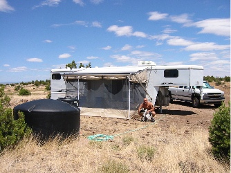
Let me take a moment to describe this trailer. It’s a horse trailer with living quarters. For those of you who don’t know much about the kinds of things horsey people know, imagine a very long (about 35-feet), gooseneck trailer (the kind you have to pull with a pickup), with a travel area in back for horses and a living area up front for people. Our trailer is a pretty nice one, as these things go. It has space in back for three horses and a separate tack closet (where you store the saddles, bridles, etc.). Its tiny bathroom has a shower, toilet, sink, and closet. The fridge is remarkably large (for a trailer) and the freezer can get cold enough to make ice. There’s a two-burner stove, a tiny kitchen sink, some counter space, and a lot of cabinets. There’s also a sofa that converts to a 1-person-under-5’8″-tall bed and a big, queen sized bed over the gooseneck. There’s a microwave and an air conditioner, but a powerful (and noisy) generator (which we don’t have) is required to make them work. I use the microwave to store bread and crackers and the air conditioner as a place to bash my head once a week (on average) when I climb out of bed.

Our property is off the grid. That means there are no utilities at all and not much of a chance of getting any. Fortunately, the trailer has very low energy needs (unless you want to heat leftovers in the microwave). There are two batteries that power the lights, the stereo/CD player, the fan for the heater, and the water pump. A solar panel, which we added after purchasing the trailer, does an excellent job of keeping the batteries charged. (Arizona has lots of sunshine!) The fridge, hot water heater, and heater run on propane. There are two good-sized tanks for that. We have 2100 gallons of water storage on the property and the trailer is hooked up to that, along with a pump to get the water pressure we need. And the trailer is currently parked right over the septic system inlet, so all the waste water (black and gray) goes down the pipe to a tank that we’ll never be able to fill.

So here’s the big picture.

I’m living in a trailer with approximately 20 square feet of usable floor space, parked on 40 acres of high desert land. To get to my place, it’s a 5-mile ride up a dirt road that requires 4WD in wet weather. Although the closest house is only a quarter mile away, it is unoccupied; my closest full-time neighbor is about 4-1/2 miles back down that dirt road. At this point, I’ve been here for more than two weeks straight and I haven’t seen a single car drive by. Remote? I’d say so.

There’s no television, Internet, or telephone here. I have a stereo/CD player that is on during my waking hours to mask the incredible silence of where I am. I listen to a lot of NPR and know all the current events in Iraq. My cell phone gets an unreliable reception. I can make calls when I sit or stand in a certain place and switch to Analog Only mode before I make the call. I can’t get calls. To use my laptop, I need to plug it into an inverter that uses a cigarette lighter jack to connect to the trailer’s electrical system. The power outlets generously scattered throughout my living space are dead without a generator or a VERY long cord. There’s no garbage pickup. I take my trash to Papillon’s parking lot dumpster every few days.

My bed is very comfortable and the shower water is nice and hot. The stove works well, but an oven would be a nice addition. I can’t run the heater all night because of the noise it makes and my fear of carbon monoxide poisoning (yes, there is a detector, but I don’t trust it). A few nights, it got down to the low 40s inside. I was warm in bed but did need the heater to warm things up before my morning shower.

The camper has an awning with a screened-in room. When set up, it triples the floor space and doubles the living area. We had it set up when I first came. Unfortunately, high winds beat the crap out of it (sorry, but there’s no delicate way to describe the abuse it took), pulling out stakes and tearing it away from the camper regularly. The sound of the wind beating against it and the resulting shaking of the camper kept me up at night. Helicopter pilots need sleep, so I took it down. I still have a picnic table out there.

Howard Mesa
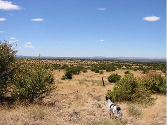
Outside, I have a 360° view of the area around me. To the east are the snow-capped San Francisco Peaks, the highest mountains in Arizona. To the south is Bill Williams Mountain, just south of Williams, AZ. To the west, my favorite view, is an unobstructed look at the high desert. On a clear day, when the wind hasn’t kicked up desert dust, I can see 100 miles or more, all the way out to Mount Trumbull on the Arizona-Utah border. To the north is Red Butte and, beyond it, the north rim of the Grand Canyon.

The terrain here is high desert, with long golden grass and short juniper and pinyon pine trees. It’s incredibly beautiful in the morning, when the golden early morning light first hits the gently waving grass and brings out the texture of the hills and mountains in the distance. There’s a lot of firewood — the rancher who previously owned this land thought he could grow more grass with less trees, so he bulldozed them here and there. We have a big fire pit and occasionally have campfires for cooking or camp ambiance. The wood smells terrific when burning. Unfortunately, I won’t light a fire when the winds are blowing and this spring they’re blowing almost all the time.

PhotoAlthough the property is fenced in, wildlife can still get in. There was a single deer, a doe, about 100 feet from my front door the other morning. Elk and antelope move through about once a week. Coyotes are always nearby, howling or barking or trotting past. There are some birds, but not as many as you’d expect. This is the first thing I saw when I woke up this morning. In case you’re wondering, its an elk yearling.

At night, it gets VERY dark. And I’m pretty sure that you can see more stars from here than anywhere else on the planet.

At Howard Mesa
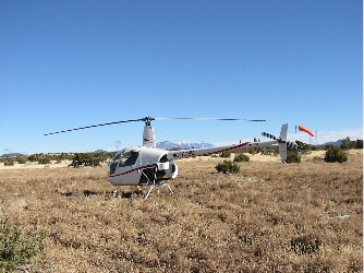
The camper is set up at the widest part of the property, which is also the highest point on the mesa. The area behind it is nice and flat and clear of trees. I have a windsock that we installed soon after buying the land. Last night, I flew my helicopter “home” from work at Papillon and landed it fifty yards from the trailer. No one complained. Who could? There’s no one here but me. Here’s Three-Niner-Lima in a typical parking spot. In the distance, you can see Mount Humphreys.

Oddly enough, I’m really enjoying the solitude up here. I spend the day flying tours over one of the seven wonders of the world, interacting with co-workers and tourists from all over. After five hours in the air and at least another two hours on the ground waiting for fuelers and loaders, I’m tired. I don’t want to interact with people anymore. I just want to relax someplace quiet. You can’t get much quieter than this.

The other day I came back to Wickenburg. Mike flew up to Grand Canyon airport in his Grumman Tiger and picked me up so I wouldn’t have to drive. We got into town and I looked around. And I realized that I really hadn’t missed it that much. After spending a hectic evening and early morning catching up on paperwork and other things, I flew my helicopter back to the Grand Canyon for a few more days of work.

And quiet solitude in the middle of nowhere.

Barnstorming in a Ghost Town

How Mike, John, Lorna, and I are surprised by a successful desert barnstorming gig.

It started about a month ago. Janet and I had done some desert barnstorming and had ended up in Congress, across from the Congress Trading Post. We’d talked to some of the locals and they’d suggested that we go out to Stanton, a ghost town about eight miles southeast, when they were having one of their “outings.”

Stanton, AZ was a huge mining community back in the 1800s. The story goes that a group of settlers were traveling through the area, led by some Indian guides. In their travels, they crossed a mountain that came to be known as Rich Hill. In a place that came to be known as Potato Patch, they found gold nuggets the size of — you guessed it — potatoes, right on the surface. The miners came and the town sprung up in a valley just west of the mountain.

Stanton was quite a community in its day. It boasted an opera house, hotel, and stage stop. These building still stand, preserved and protected from vandals by the town’s current owners, the Lost Dutchman’s Mining Association. (I can’t make this stuff up.)

The Lost Dutchman’s Mining Association is a club of people interested in looking for gold. The club owns several properties in the southwest. If you’re a member, you can camp on any of the properties for a very reasonable daily, weekly, or monthly fee. But best of all, you can dig on the club’s mining claims, like the ones around Stanton, where they’re still occasionally finding impressive gold nuggets.

The Lost Dutchman’s Mining Association has several outings at Stanton every year. I missed the one in December, which was supposed to be the big one. (Let’s hope I don’t miss it next year.) But I did make it to the one on February 21, 2004. And I brought Mike, John, Lorna, and Tristan’s R44.

I’d made arrangements two weeks before with Linda and Larry, the town’s caretakers. The rides would be $25 per person and would go up and around Rich Hill, with views of Potato Patch. I didn’t expect to do many rides. After all, the people who go to Stanton are an older crowd and older folks tend to be afraid of helicopters. But I was wrong.

We arrived five minutes late and there were so many people waiting around my landing zone that I couldn’t land there. Instead, I had to land on a nearby road and let Mike out with instructions to shoo them away. When I repositioned, Mike, John, and Lorna went into action. They loaded my first group of passengers before I could even think of getting out. When the crowd finally faded away more than two hours later, I’d taken 26 people on rides.

The ride itself is worth mentioning in some detail. Stanton is at about 3500 feet. To view the top of Rich Hill and Potato Patch, I had to climb to 5500 feet. I took off from my LZ, climbing carefully over some power lines, then turned toward the ruined ghost town of Octave, in the next valley. I flew up that valley, climbing at 800 to 1200 feet per minute (depending on my payload). At the end of that valley, I hopped over the mountain to the valley in which Stanton lies and headed toward Stanton, which looked like oh-so-many tiny trailers off in the distance. After a quick peek at Potato Patch — which is kind of a bowl at the top of the mountain — I began a steep 1000 feet per minute descent. Of course, that’s not steep enough to be at ground level by the time I reached Stanton, so I headed out over the desert about a half mile before looping back over Stanton and then looping back again to my LZ. I did this about 10 times and really had the hang of it by the time we were done.

I took my ground crew on the same tour before heading back to Wickenburg. I was tired. I’d flown nonstop for more than two hours and I’d never even gotten out of the helicopter. When we landed in Wickenburg, I checked the hobbs meter, which only runs when the helicopter’s collective is up. Exactly 2 hours. For the first time since starting my desert barnstorming, I made some serious money.

Best of all, Mike, John, Lorna, and I had had some fun.

And the Lost Dutchmen members? They’ll be talking about it for weeks to come.

One more thing…if you should happen to be watching the Outdoor Channel and see some aerial video of the Stanton area, you know who flew the camera around.