Four of us join Mike on his annual ride to Wickenburg Mountain.
Every winter, Mike takes Jake, his horse, on a ride to Wickenburg Mountain. Altough this mountain is only about 3 miles as the crow flies from our house, there’s no trail that goes right to it. Instead, you have to pick your way along a maze of trails that go up and over or around about a dozen ridges.
Wickenburg Mountain is not named Wickenburg Mountain on any map I have. I don’t know where Mike got that name for it. Someone probably called it that and Mike remembered the name. If you’re looking at a topo map for Wickenburg, it’s the 2977-foot peak at the north end of the Vulture Mountains, south of Turtleback Wash.
I don’t usually go with Mike on this ride. He’s out most of the day and he always brings back stories of bushwhacking through the desert. While there isn’t much bush to whack in the desert, riding off trails (which is what I mean here) can often take you to the edge of cliffs that even horses can’t climb down. I don’t enjoy putting my somewhat neurotic horse through that kind of experience, especially with me on his back.
But yesterday, he’d invited Janet and Steve, who were visiting from Colorado, and Hans, who has recently gotten over a broken ankle suffered when his horse fell on him. I thought it would be nice riding with a small group of friends, so I went along for the ride, too.
Also along for the ride were Jack the Dog and Janet and Steve’s two dogs, Tasha and Maggie. And when my neighbor’s dog, Trixie, saw us leaving, she decided to join us, too. Tasha wasn’t too happy about that and kept attacking her, but after a while, they calmed down and tolerated each other nicely.
We started out from our house, taking the trail beside my neighbor’s property that would take us into the state land south of our house. We rode familiar trails that dropped us into a tributary of Turtleback Wash, where a Jeep trail ran.
The ride up to that point had been pleasant, following trails we knew. It was a lightly overcast day, cool and comfortable. We saw some mule deer, which gave Jack something to chase. As I rode, I began stripping off a few outer layers. My horse was behaving well — which means he was behaving like most other horses, for a change. He was even trotting nicely when we trotted. And he hadn’t bitten the butt of the horse in front of us yet, either.
From the Jeep road, things got iffy. The road ran mostly northeast to southwest, but we needed to go southeast. But we followed the road southwest, looking for a trail or road that would branch off to the left. Steve was leading at that point and he led us right by a possible trail. I’d seen it but didn’t think it was a trail. It turned out to be an old mining road. We followed it in the right direction, climbing a steep hill. We paused near the top to rest the horses and give the dogs some water. Then we continued and, moments later, the road ended.
Dang.
Mike led and the bushwhacking began. We rode over steep, rocky terrain, past nasy cacti and thorny trees. We climbed, we descended. At one point, we reached what I thought was the edge of a cliff. But Mike steered Jake down it and Jake, the good horse that he is, just went. We followed.
Eventually, we ended up on another Jeep road in another wash. We could see Wickenburg Mountain and it was much closer. We even saw a string of four horses and riders coming down one of its old mining roads. But there were more hills to climb over or around. Fortunately, there were also a lot of roads. The trick was to pick the right ones.
We did pretty well. At one point, we rode up a steep piece of road and I heard Hans say, “Oh no. That looks like the kind of place we fell.” He was referring to his recent horse accident, when he tried to walk his horse up a steep hill and his horse slipped back and fell on him, breaking Hans’s angle and chipping numerous bones in the horse’s foot. We hurried up the hill and I was comforted to hear him right behind me.
 We reached the base of the mountain and climbed on another road. About two thirds of the way up, on a road that wound past the front of the mountain’s peak, we stopped for lunch. We tied the horses to bushes along the road; they were so tired, they didn’t seem interested in moving. Then we sat down on the rocky slope, opened up our lunch bags, and ate.
Tasha and Trixie had a huge fight right behind my back, nearly knocking me over, but they broke it up when Mike squirted them with his water bottle. Then they settled down and rested. Jack the dog was smart and hung out in the shade.
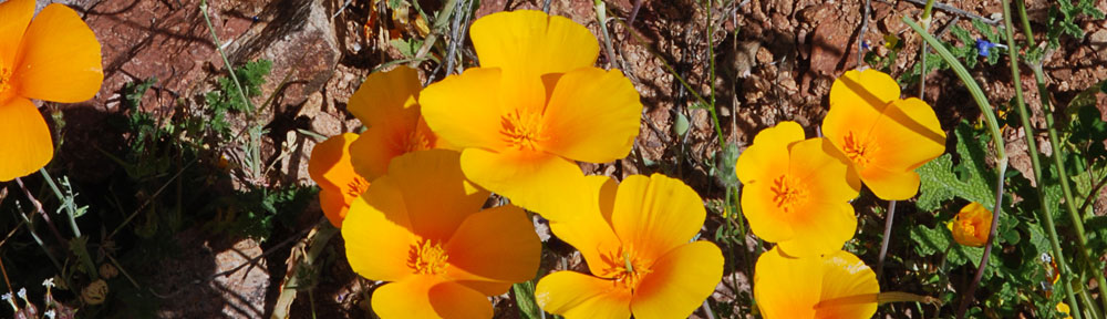
Our lunch spot had incredible views of Wickenburg several miles to the north and east of us. But for some reason, I didn’t take any of those pictures. I did get one of Jake with the town in the background, far in the distance. But most of the rest of the photos I took were for wickenburg-az.com, my so-called “labor of love,” which features random header images. To get just the right image, the photo needs to have something on the left and nothing much on the top right. Go to the site and keep refreshing the page to get an idea of what I’m looking for. The image changes on every page, every time it’s refreshed. There are about 20 images now and one blank image that I’m trying to remove.
(But Larry doesn’t want to read about this. I’m starting to talk too much about computers. Sorry, Larry.)
 After lunch, we mounted up again and continued on a trail that led to the back side of Wickenburg Mountain. The trail climbed up through beautiful Sonoran desert to a saddle between the mountain’s peak and a lesser outcropping. This is where I took my favorite photo of the day — this vertical shot of the peak’s side and some saguaro cacti. I was very surprised to see a fence and drag gate up there. Mike dismounted and handled the gate for us and we all squeezed through. On the other side of the fence was just a tiny bit of level ground before the land dropped off on a steep downhill slope. There was a trail and Mike led the way down it.
We wound around the back of the mountain and joined up on some old mining roads again. We followed those back toward the main Jeep road. And that’s where we made our wrong turn. If we’d gone right, we would have hooked back up with Turtleback Wash and, from there, we could have found easy trails back to our house. But we went left, following the Jeep road back toward where we’d bushwacked down the mountainside.
How do I know all this? It isn’t because I have an excellent sense of direction and keen eye for landmarks. My sense of direction is good but my eye for landmarks sucks. That’s one of the reasons I had my GPS with me. And my GPS has a moving map with the local topo maps loaded in. I could see exactly where we were and exactly where we needed to go to avoid bushwhacking.
But Mike wasn’t interested in any of that. “We’re not in a hurry,” he told me.
Well, I wasn’t in a hurry, but I was interested in getting home. Especially since most of our water was gone and I was worried about Janet’s dogs, who seemed to have some trouble keeping up.
So we went left down the road. There was a gate across the road and Mike opened it so we could all go through. And we continued along the wash while the hills rose ever taller on both sides of us. Soon, we were riding into a narrow canyon. And then the canyon ended with a steep rocky cliff carved out by the force of water over thousands of years.
Dead end.
We paused there to give the dogs more water and explore the cliff face. There was a neat shelf where you could imagine water gathering in a pool after coming down a flume. (This photo doesn’t do the place justice.) The horses got goofy in the narrow area and Steve’s horse almost ran off. So we mounted up and backtracked, looking for a place where we could — dare I say it? — bushwhack over the ridges to the north.
So the bushwhacking began again. This time, the hills were steeper and, for some reason I can’t comprehend, we managed to get separated. Steve was the first to get down to the wash on the other side. Hans made it soon afterward. Then Mike and I, together. Janet was trapped on top of the ridge, unable to find a safe way down. I think the problem was that none of the ways down looked safe and Janet just happened to be a lot more cautious than the rest of us. So Steve rode back up and she followed him back down.
More bushwhacking. I really don’t like it. Cherokee, my horse, managed to cut his nose on a tree or something, so he wound up with a bloody nose. Janet’s dogs were definitely trailing behind. We stopped to give them water again and pretty much finished off all the water. We’d been out for about five hours.
We finally climbed onto a ridge and saw a familiar Jeep trail ahead of us. A few moments later, we were on the trail. We took turns leading the way. Soon, we were coming back through the gate by my neighbor’s house.
We unsaddled the horses and hosed ours down. (Cherokee hates getting hosed, but he really needed it. Of course, he got us back by rolling in horse manure right after his “bath.”) Hans and his horse hurried home while Janet and Steve put their horses in one of our corrals and joined us up at the house for drinks. Trixie went home. Janet’s dogs were walking on very sore feet. They admitted to us that their dogs had become “couch potatoes.” Our dog, Jack, was obviously tired, but didn’t seem quite as sore.
According to my GPS, we’d travelled 10.6 miles in about 3-1/2 hours of riding with about 1-1/2 hours of non-movement time. (I figure that Jack the Dog and Trixie must have covered at least 50% more distance.) Our average speed was 3 MPH; our top speed (on a gallop, I suppose) was just over 10 MPH.
This morning, it was me who was sore. You don’t realize how many muscles you use when you ride a horse. I think I can feel every one of mine.
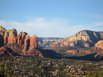 We’d reserved two Red Rock View rooms for the night. The rooms included 2 queen beds, a deck overlooking the views, and a kitchenette with a small fridge, microwave, and sink. And a bathroom, of course. Not what I’d call luxurious, but certainly very comfortable. And the views! At about 500 feet above the town, we didn’t have to look at any ugly commercial buildings. Sedona’s famous red rocks were right there. The photo here shows the view from our deck. The rock formation in the left center is called the Coffee Pot. (Think percolator.)
 We reached the base of the mountain and climbed on another road. About two thirds of the way up, on a road that wound past the front of the mountain’s peak, we stopped for lunch. We tied the horses to bushes along the road; they were so tired, they didn’t seem interested in moving. Then we sat down on the rocky slope, opened up our lunch bags, and ate.
 Our lunch spot had incredible views of Wickenburg several miles to the north and east of us. But for some reason, I didn’t take any of those pictures. I did get one of Jake with the town in the background, far in the distance. But most of the rest of the photos I took were for
  After lunch, we mounted up again and continued on a trail that led to the back side of Wickenburg Mountain. The trail climbed up through beautiful Sonoran desert to a saddle between the mountain’s peak and a lesser outcropping. This is where I took my favorite photo of the day — this vertical shot of the peak’s side and some saguaro cacti. I was very surprised to see a fence and drag gate up there. Mike dismounted and handled the gate for us and we all squeezed through. On the other side of the fence was just a tiny bit of level ground before the land dropped off on a steep downhill slope. There was a trail and Mike led the way down it.
 We paused there to give the dogs more water and explore the cliff face. There was a neat shelf where you could imagine water gathering in a pool after coming down a flume. (This photo doesn’t do the place justice.) The horses got goofy in the narrow area and Steve’s horse almost ran off. So we mounted up and backtracked, looking for a place where we could — dare I say it? — bushwhack over the ridges to the north.
 Mike already had Jack out of the helicopter as I was cooling the engine down when Robin came in for a landing. Although I thought there was enough space beside me, Robin didn’t think the spot looked level enough. He wound up parking a few dozen yards east, on the same side of the strip.
 After lunch, we took a short hike down to the river. It was rushing pretty good and the sound of the flowing water was great. There’s plenty of space down there to camp and we hope to come back in the spring, when it’s warmer at night, to camp out. I’m hoping Jason and his fiance, Becky, can join us. Jason still flies in with the Citabria that’s older than he is. But somehow, I don’t think we’ll camp by the river. I think we’ll be up by the runway, by that picnic table.
 After scouting around down by the river, we followed an old road up to a shack built high above the river. There were some cattle pens there and the place was pretty beat up. Supports for the porch roof had collapsed and the metal roof panels hung down against the side of the building. The concrete pad the place was built on had 1964 scratched into the cement. Inside, the building showed signs of recent use, including a new set of steps leading up to one of the bunks and a sleeping bag in decent condition.
 Jack spent most of the ride back lounging in the back of the helicopter, stretched out on both seats. He was tired after all his running around. Mike shot this photo of him looking out the window as we neared the airport. That’s Wickenburg down below — one of the motels and Denny’s, with the newly built apartments and condos below them. It almost looks as if Jack was enjoying the view. Almost.
 So on December 30, at 12:30 PM, I arrived at Stanton as scheduled and landed on a seldom-used road near the campground. My ground crew — Mike, John, and Lorna — got out and set up a little table. I shut down and waited for the crowd to gather. They came in pairs and trios and when I had at least 4 people waiting, I started up again. Lorna took the money — $30, including tax, per person. Mike and John gave the safety briefings and loaded up the passengers. Then I took off toward Wickenburg, climbing, climbing, climbing. I rounded the south end of Rich Hill and climbed up its east side. The passengers had excellent views of what was left of Octave and the mining activity going on in that canyon. Finally, 2000 feet above Stantons’ elevation, I rounded the north end of Rich Hill, still climbing. We were over the next valley, with Stanton far below us in the mouth of the canyon. I pointed out the Potato Patch and the miner types oohed and aahed. I started the descent, coming down at a rate of more than 1,000 feet per minute. On the way down, I pointed out Wickenburg, far to the south, and Congress, to the west. Also, North Ranch (which, you may recall, the management claims occupants are too old for helicopter rides) and the dairy farm. Even at a 1,200 feet per minute descent rate, I can’t get to Stanton without overflying it and turning back, making an elongated spiral to my landing zone.
 I flew for a few hours, taking a break for lunch before starting up again and flying some more. The route started from our desert clearing, which was just big enough for Zero-Mike-Lima to fit comfortably, to the east alongside the base of the mountain behind Robson’s. I climbed as I flew, pointing out where Wickenburg would be if we could see it (we couldn’t), Vulture Peak, Congress, and Alamo Lake if we could see it (we couldn’t). Then I came along the back side of the mountain, crossing over a saddle on the west side. (There were a couple of guys and a dog working an old mine shaft up there and I wonder what they think of the helicopter flying over them every 10 to 12 minutes or so.) I came through the canyon where Robson’s is nestled, pointing out the trail to the petroglyphs along the way. I flew jsut to the east of town, where everyone could see me but not be bothered by the sound of the helicopter, before circling around to land back in my LZ.