Highest Duty

A book review.

Highest DutyLast night, I stayed up late to finish reading Highest Duty by US Airways pilot Chelsey B. “Sully” Sullenberger. Captain Sullenberger was the pilot in command of US Airways Flight 1549, which landed with no loss of life in the Hudson River on January 15, 2009.

I’d been wanting to read the book for a while but I kept putting it off. I wanted it to be my first purchased ebook experience. I was supposed to get a Nook for Christmas, but the idiots at Barnes & Noble were completely clueless about customer service and timely order fulfillment, so I canceled the order. I wound up with an iPad in April. After weighing the benefits and drawbacks of ebook reader software — iBooks, Kindle Reader, and B&N Reader — I decided to go with the Kindle software and ordered the Kindle edition of the book from Amazon.com. From what I hear from Twitter friends, the iPad makes a better “Kindle” than Amazon’s Kindle.

On Heroes

I’ve always been intrigued by Captain Sullenberger’s modesty and apparent reluctance to bask in the limelight of his extraordinary experience. People call him a hero but he [rightly] refuses that title. He quotes from a letter he received after his Hudson River landing: “I see a hero as electing to enter a dangerous situation for a higher purpose, and you were not given a choice.”

I agree with this definition of a hero. Captain Sullenberger did what he had to do and was fortunate enough to have the knowledge, experience, demeanor, and team to carry it off successfully. His love and respect of life — including, of course, his own — is what motivated him to do everything he could to succeed.

In many ways, that’s better than being a hero. When a terrible situation was thrust upon him by circumstances he could not change, he rose to the occasion and emerged victorious, saving the lives of 105 people. Along the way, he gave the rest of us hope — after the terrorist attacks of 9/11, in the midst of a serious economic recession, with wars going on in the Mideast — he showed us what people can accomplish when put to the test. He gave us the happy ending we all needed.

It Wasn’t a “Miracle”

Another thing that intrigued — and, I’ll admit, pleased — me about Captain Sullenberger was his failure to credit his success to the intervention of some supernatural being. I’m talking about God.

I can’t tell you how sick I am of seeing famous athletes and celebrities and just plain people thank God for something good happening to them. Scored a record number of goals in a basketball game? Thank God! Won a Grammy? Praise Jesus! Tornado took out the house next to yours but left yours unscathed? God was watching out for you!

It makes me sick. People don’t want to give themselves credit where credit is due. They work hard, they train, they practice, but they give God credit for getting the ball through the hoop. They learn music, they practice singing, they get a great producer who helps package their material, but they give Jesus credit for winning that Grammy. They don’t want to admit that luck has a place in our lives — good luck preserves one house while bad luck takes the one next door away. What of the people who lost the basketball game or the Grammy or their home? Did God simply not like them as much? And what about when these winners get their own dose of bad luck — injury, illness, scandal, death? Did God change his mind about them?

Captain Sullenberger, however, did not thank God or any other supernatural being for the positive outcome of his Hudson landing. At least I didn’t hear him do so in any article, interview, or elsewhere. I wanted to read the book to be sure that he didn’t thank God within its pages. He didn’t.

And that just makes me respect him even more.

The Story

The book mingles autobiographical material with events from the day of the landing. The autobiographical material was presented in a roughly chronological order, but did bounce around a lot with side stories, including references to the Hudson landing. I’m not sure that was the best approach, but it did keep me reading.

Captain Sullenberger is clearly a true pilot. He entered aviation because of his love of flying. From his start as a teen, he took aviation seriously, learning what he could to be a better, safer pilot. He understands the importance of knowing an aircraft’s systems inside and out. He understands the value of studying past accidents to prevent future ones. He also understands that all the things that happen in our lives define who we are and how we will react in a given situation.

Flight 1549 from Wikipedia

This iconic photo of US Airways Flight 1549 in the Hudson River by GregL originally uploaded to Flickr can be found on Wikipedia under a Creative Commons 2.0 license.

A detailed discussion of the events of January 15, 2009 begin about 60% through the book. The story is riveting. He combines his narrative of what happened with references to his past that he believes influenced him to make certain decisions. For example, his knowledge of research into why military pilots sometimes ejected too late is part of why he decided not to worry about saving the airplane by attempting an airport landing and instead concentrate on saving the people by landing in the river. (There’s a lot more to his decision than that; this is just part of what went into it.)

Throughout this part of the book are bits and pieces of the cockpit transcript, recorded by microphones during the flight — the so-called “black box” data. Even though I knew how it would end — don’t we all? — I found the details fascinating. It was a great example of teamwork between Captain Sullenberger and his first officer, Jeff Skiles. Later in the narrative, it was clear that the flight attendants were also part of the team, helping passengers off the plane in as orderly a manner as possible.

The aftermath of the experience also made interesting reading. Getting an inside look at the mail Captain Sullenberger received from people on the plane — as well as many people who had no direct connection to the flight or its passengers at all — revealed the psychology of people. I’m not the only one who appreciated the happy ending to that seemingly doomed flight.

The Soapbox

One of the complaints people have had about the book is the soapbox aspect. Captain Sullenberger believes that airline pilots are not treated as well as they should be by their employers considering the hours and responsibilities of their work. He believes that pay cuts and pension cuts are making it ever more difficult to attract and retain quality pilots who actually care about their work. He suggests that airline pilots are like bus drivers of the sky.

Although I don’t have intimate knowledge of the airline industry, as a professional pilot who has worked for a large tour operator, I know exactly what he means. Aviation employers don’t care how good a pilot is. As long as the pilot meets insurance requirements and can do the job, all that matters is how much that pilot costs. In my experience, many employers would rather hire a cheap, entry level pilot than a seasoned professional who costs more. They don’t see the benefit of the experience. They’re gambling, of course, on the equipment and circumstances of flight — when something goes wrong, will the entry level pilot have the experience and knowledge to bring the aircraft and passengers back safely?

In the airline industry, pilots are locked into their employers for seniority. If they leave one airline, they lose all seniority and start at the bottom at their new employer. This prevents experienced pilots from looking for better jobs. It stagnates the employee pool. And although Captain Sullenberger didn’t mention this, it prevents good ideas from one airline from migrating to another.

Captain Sullenberger does discuss how many airline employees have simply stopped caring about anything other than what’s in their job description. As budget cuts reduce non-essential staff, customer service suffers. Captain Sullenberger talks about his personal experiences going the “extra mile” to help passengers who can’t get the help they need from other airline employees. He talks about how most airline employees are simply tired of doing other people’s jobs. He doesn’t blame them — he hints that they’re underpaid for what they’re supposed to do — but he does decry the system that results in this poor attitude.

He also believes that budget cuts have the potential to reduce safety. A good example of this is the emergency procedures book that his first officer needed to consult on the loss of both engines. In the past, the book had numbered tabs that made it easier to find content. The airline, in a cost-cutting measure, had stopped including the tabs, making it necessary to thumb through the book and look at individual page headings to find content. In the slightly more than three minutes the cockpit crew had to land the plane without engines, every second was valuable. Yes, this flight had a happy ending — but could other flights be lost due to cost cutting measures like this? It certainly makes you wonder.

My feelings about Captain Sullenberger’s soapbox are mixed. I didn’t like reading his complaints, but, at the same time, I knew they were valid. And I know that his experience and the interviews, articles, and books that come from it are the perfect way to get the message out.

While Captain Sullenberger was careful not to criticize his airline, it’s clear that US Airways is just as bad as the others when it comes to matters of pilot compensation and cost-cutting. Perhaps his insight will help make the situation better?

Sadly, it probably won’t.

Thumbs Up

In all, I give the book two thumbs up. While it’s especially good reading for pilots and others interested in aviation, I also think it makes a good guide for young people who want to make something of their lives. And for the rest of the world, it’s a great look at one of the most amazing emergency landings we’ll likely ever see.

Helicopters 101: Flight Planning

The basics of cross-country flight planning for helicopters.

Articles in the Helicopters 101 series:
Flight Planning
CG
Weight
Hover Charts
Ground School

Recently a reader of this blog wrote to suggest that I cover cross-country planning as a blog topic. I searched my archives and found that I already had. My post, “Flight Planning,” goes into a great deal of detail about the process I use to prepare for Part 135 charter flights, which require a complete flight plan. But that’s probably not what this reader was talking about. I think he was more interested in the nuts and bolts of creating a flight plan.

This weekend, I have to make three relatively long cross-country flights:

  • Wickenburg, AZ (E25) to Page, AZ (PGA) – 189 nm direct
  • Page, AZ (PGA) to Salt Lake City, UT (SLC) – 232 nm direct
  • Salt Lake City, UT (SLC) to Seattle, WA (BFI) – 601 nm direct

I’ve flown the route from Wickenburg to Page and back numerous times. I’ve done Salt Lake CIty to Page once and Seattle to Salt Lake City once. I figured I’d use the PGA to SLC flight, which I’ll be doing alone, as an example of how I plan a flight.

Weather

A few days before the scheduled flight, I start checking the weather along my route. I use the National Weather Service’s NOAA Web site for weather information. After all, the NWS is the source of all the weather data for the United States. That’s where the Weather channel and Duats and the FAA get raw weather data. Although each weather reporting organization may interpret it slightly differently, it’s all based on the same stuff. And the NWS site doesn’t bombard me with obnoxious advertising.

A lot of folks use the Aviation Weather link to get aviation weather information. I don’t — at least not a few days out. Remember, I’m flying a helicopter. I’m 500 – 1000 feet off the ground. I don’t care much about upper level disturbances, the jet stream,or icing in clouds. I’m not getting anywhere near that stuff.

Page Weather

The graphic weather forecast for Page on the morning this post was written.

What I’m interested in is forecasted conditions for the departure and arrival airports, as well as any cities in between. So, in this case, I would check out the weather forecast for Page, Salt Lake City, and possibly Richfield, which is roughly halfway between the two. I’ll pay close attention to the forecast for my day of travel, as well as the day before and after.

What I see today is relatively poor forecasted conditions for Saturday, the day of my flight, with chance of rain or snow at each location. Not what I want to see, but remember, it’s a forecast. It will probably change. I have to hope it gets better.

Route

Next, I plan out my route. Although I listed straight-line distances at the beginning of this piece, I seldom fly in a straight line. Instead, I try to find a route that’s a compromise between a straight line — which, out in the desert, usually means doing a lot of flying in the middle of nowhere — and following roads — which is where people will be if I need help.

Now I need to make it clear that unless there’s a road going the way I need to go, I’m not going to follow roads to get from Point A to Point B. I don’t want to go out of my way — at least not too far. Helicopters are expensive to fly and I’m not made of money. The time budget for this trip is 2 hours — that’s what the client paid for — and I’ll need all of it and then some. So what I want is a compromise that puts me near roads for part of my trip.

I plan my route with charts. World Aeronautical Charts (WACs) are very handy for long cross-country flight planning. But sectionals offer more detail.

Of course, I cheat. I use SkyVector.com. It puts the charts onscreen and enables me to do some very basic flight planning — mostly distances and directions. As the site warns — probably with the advice of lawyers — it’s not for navigation or preflight use. But I use it for preliminary planning. It really helps me get a good idea of where I need to go.

Options

The pink line at the bottom is the direct route from Page to Brice; the red and blue lines are my two options for continuing northbound without overflying 10,000 foot mountains.

In this case, I’m seeing that a direct flight from Page (PGA) to Bryce Canyon (BCE) would take me 57 nm mostly over remote, high desert terrain, climbing from about 4300 feet to over 7000 feet. No major mountain ranges to cross along the way — and that’s good.

From there, I can follow the East Fork of the Sever River and the road beside it northbound between a pair of mountain ranges topping out at over 10,000 and 11,000 feet, then follow a pass that’ll hook me up with Highway 89. This map shows it as the red route. That’s the way I flew last time and the only drawback I recall was the rough air in that pass.

The other option is to continue on almost the same heading to Panguitch (U55), which will hook me up with Highway 89. I can then follow that northbound between two mountain ranges topping out at 11000 feet, staying slightly lower in overall altitude and sticking with a well-traveled road. This map shows it as the blue route.

Completed Route

My planned route, roughed out on SkyVector.

I continue this process for the entire trip. This one’s pretty easy; I’ll be following Route 89 most of the way. When I get to the outskirts of Salt Lake City, I’ll be following I-15. This turns my 232 nm trip into a 259 nm trip and adds at least 15 minutes of flight time. But I’ve minimized my flying time over the middle of nowhere without detouring too much out of my way. The WAC charts I pasted together here from SkyVector screenshots give you an idea of what the entire route looks like. I can also see that my flight without wind could be as long as 2-1/2 hours. My helicopter’s endurance is just 3 hours, so I need to consider the possibility of needing a fuel stop if I hit headwinds. Fortunately, there are plenty of airports with fuel along the last 50 miles of my route.

By the way, the main benefit to following a road when you enter busy airspace and don’t know the local reporting points is that you can state your position to ATC in relation to the road. For example, “Helicopter Zero-Mike-Lima is ten miles south over I-15” is a very definite location.

Once I get a rough outline of the course, I go into detail with sectional charts. I buy them as needed for my cross-country flights. I’ll check to be sure there’s no special airspace or weird activity (think gliders and ultralights) along the way. I’ll also look for charted power lines — not that I’ll remember them when the flight time comes. I’ll make a cheat sheet of airport names, designators, elevations, and frequencies so they’re easy to enter into my GPS for added navigation assistance during flight.

Although I don’t usually mark up my local charts (Phoenix sectional and terminal area chart), I don’t mind taking a highlighter to the Las Vegas and Salt Lake City Sectionals I’ll use for this trip. I’ll also have a Salt Lake City terminal area chart on hand. Before I start my flight, I’ll fold them all neatly to expose the route. With just one hand to fiddle with charts, it’s much easier to prepare before lift off.

Destination Information

On this particular trip, I’ll be landing at Salt Lake City Airport, a Class Bravo airport I’ve never landed at before. I’ll need to know where on the airport I’ll be landing so I don’t sound like a complete idiot when I talk to the tower.

Airport Diagram

The airport diagram for SLC. General aviation is handled in the southeast corner, not far from the I-15 freeway.

I could pull out my Airport/Facilities Directory and look up the airport, but that green book is already stowed in the helicopter for the trip. So instead, I’ll hop online to the FAA’s AeroNav Services (formerly NACO) web site. Once there, I’ll click the link for Free Digital Products and then click d -TPP and Airport Diagrams on the page that appears. (Note that you can get a PDF of the page(s) for a specific airport from this site, too.) I’ll use links and search to get the Airport Diagram for SLC, which will be downloaded as a PDF. I can print it out for future reference and put it with my charts.

I’ll also go to AOPA Airports and get information for SLC. I’m interested mainly in FBOs. I was told to go to Million Air, so I want its location, frequency, and phone numbers. AOPA Aiports also shows a zoomed in satellite image of the FBO’s location, making it easy to mark on the airport diagram.

While I’m at the AOPA Airports site, I’ll also jot down the phone numbers for the AWOS or ASOS systems along my route. I’ll program these into my cell phone. This way, if I need up-to-date weather information for a specific airport, I can get it by simply calling. This has come in handy in the past in marginal weather conditions. I have quite a few airports stored in my computer and phone.

Note that I always get airport frequency information from FAA sources: up-to-date charts or the Airport/Facilities Directory. No online database that isn’t maintained by the FAA is guaranteed to be accurate. There’s nothing worse than trying to land at a towered airport and having the wrong frequency for it. I’ll also update my Garmin 420‘s database before this flight. I have an annual subscription, but I often skip updates because they’re such a pain in the butt to install.

Final Planning

I’ll keep watching the weather all week. If it starts to look like its getting worse, I’ll start thinking about rescheduling my trip. In all honesty, the only thing that would stop me from doing the flight would be winds in excess of 40 miles an hour (possible, but not likely), low clouds (definitely possible), or freezing rain (possible). Although I mostly fly in great weather here in the desert, I’ve flown in ugly weather, too. A fair weather pilot should not be flying for hire.

The day before the flight, I’ll call Million Air and tell them to expect me. I don’t have to do that, but it’s better than just dropping in. They’ll also give me some insight about where to land/park. I’ll note it on my airport diagram.

The day of the flight, I’ll check the weather again. This time, I’ll use Duats.com. I’ll punch in my flight plan airports and let Duats tell me the official aviation weather and notams and give me a more precise (official) flight plan that factors in the wind.

Could I do it by hand? Yes, if I had to. But I don’t so I don’t.

I’ll also make my fly/no fly decision.

I’ll file a flight plan via Duats. I might forget to open it when I take off, though. I often do when I fly by myself. But I have a Spot Messenger that broadcasts my location to a Web site that my husband monitors. I think that’s better flight following than I could get from the FAA without climbing to 12,000 feet. (Keep in mind that I don’t have oxygen and the R44 vibrates like a coin op motel bed at altitudes above 9500 feet.)

That’s About It

That’s all there is to it. The longer the flight, the more variables to consider. This is a pretty short one. The flight from Salt Lake City to Seattle is another story. Lots of variables there. My co-pilot on that trip will plan and fly the entire route. I’ve already looked at the route he suggested and it seems fine to me. I’ll just follow along on the chart.

The main thing that makes this different from planning for an airplane flight is the altitude issue. Airplanes climb several thousand feet over terrain. Mountains don’t get in their way; they’re above the mountains. Helicopters generally don’t fly that high, so we often look for routes that take us around obstacles like 11,000 foot mountain ranges. We also have the luxury of being able to land almost anywhere if we have a problem

Flight Planning Realities

It’s more than just drawing a straight line.

Every week I get at least one weird helicopter flight request. Yesterday’s was for a flight from Scottsdale to Four Corners and back.

Four Corners

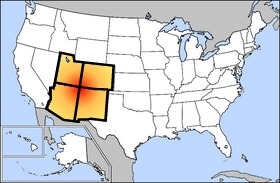
Four Corners, on a map. (Wikipedia image.)

When I say Four Corners, I’m talking about the place on the map where Arizona, Colorado, Utah, and New Mexico meet. In drawing their rather arbitrary state lines years ago, the mapmakers created this manmade point of interest: the only place in the United State where four state boundaries meet at one point. There’s a monument there that supposedly marks the exact point where the states meet. Tourists like to drive in and get down on all fours for photos with one limb in each state.

These days, the monument is managed by the Navajo Nation, which has land on three of the four states. The Colorado section is on Ute Indian land. I’m pretty sure there’s a fee to get in, but I could be wrong. I’ve driven past the point and flown over it, but have never stopped there.

So the passengers wanted to land at Four Corners, which is on Navajo land. That means I need permission from the Navajo Nation to land there. That’s the first hurdle the booking agent has to jump. (I won’t get permits for my passengers; I’ve wasted enough time trying for flights that didn’t happen.)

The booking agent evidently uses some kind of flight planning tool to estimate flight time. He estimated 2-1/2 hours each way. But the booking agent didn’t take into account the realities of endurance, refueling locations, weather, and FAA reserve fuel requirements.

I used SkyVector — highly recommended! — to come up with a basic flight plan — something I could use to estimate the cost of the flight. Its built-in aeronautical charts make it easy to identify places to stop for fuel if needed.

I learned that a direct flight from Scottsdale to Four Corners would take approximately 2-1/2 hours — just as he’d estimated. But this didn’t take into consideration the possibility of headwinds and my aircraft’s endurance. I roughly estimate 3 hours endurance on full tanks of fuel. But could I fill the tanks? I had no idea what the passengers weighed yet. And with my 20 minutes of required reserve fuel, planning a direct flight was not a good idea.

But what made it a really bad idea is that there is no fuel available between Winslow, AZ and Four Corners — a distance of 143 NM or 1-1/2 hour of flight time. Indeed, the closest fuel to Four Corners is 42 NM to the east — not on our way back — at Farmington.

My Flight Plan

SkyVector makes preliminary flight planning very quick and easy.

That meant I needed to plan three fuel stops: Winslow (INW) on the way up and Farmington (FMN) plus Winslow (INW) or Payson (PAN) on the way back. The resulting flight path is a narrow triangle totaling 549 NM and at least 5-1/2 hours of flight time. To be on the safe side, I’d estimate 6 hours.

This is what kills me about some of these booking agents. This particular one is based in Atlanta, GA. I can pretty much guarantee he’s never spent any time in an aircraft over the Navajo Reservation — which is where at least half this flight would be conducted. He has no concept of the vast distances and empty terrain a route like this would cover. He — and likely his passengers — can’t conceive of the utter boredom of six hours flying over this area. Sure, there are scenic parts, but not six hours worth. They’d be paying me close to $3,000 for this one-day adventure.

And all for what? A photo opportunity at a manmade “monument” in the middle of nowhere? Heck, look at it on GoogleMaps! There’s nothing there or anywhere near it!

Yet the booking agent will sell it to them if he can. And I’ll provide the service if it’s paid for.

I think the booking agent could do them a better service by selling them a Sedona tour or a trip up to the Grand Canyon. Or even Lake Powell, for Pete’s sake! Closer, cheaper to visit, and far more interesting.

Of course the weird requests of uninformed passengers or booking agents isn’t really my point.

My point is this: There’s a lot more to flight planning than simply measuring the distance between two points. The preliminary flight plan I cooked up here is just the first part of a lengthy planning process I have to go through if I get this job.

I have to admit that I find it a bit annoying when a booking agent oversimplifies the requirements of a flight — especially if he fails to inform his clients about what they’re getting into. In this case, it’s a long and expensive flight over the high desert of Arizona with very little of interest to see along the way.

Weight and Balance: A Primer for Passengers

Or why you shouldn’t lie to your pilot about your weight.

The other day, I booked a scenic flight for three passengers. At the time of the booking, I took the passenger names and weights — as I always do. Here’s what I was told:

Joe: 200 lbs
Bill: 200 lbs
Sally: 150 lbs

Why Pilots Ask for Weights

You might be wondering why a pilot needs the weight of passengers on a flight. After all, when you book a flight on United or US Airways, they don’t ask how much you weight. Why should a helicopter pilot care?

First of all, you should be aware that the airlines do care about weights. Weight information is required to calculate aircraft weight and balance (W&B) at takeoff and landing. The airlines are allowed, however, to use a blanket estimate for each person’s weight. This is set forth in an Advisory Circular issued by the FAA. (I found AC 120027C dated 1995, but I think this has been recently revised to account for heavier passengers; can’t find the new info, though.)

As a Part 135 operator of a small aircraft, I’m required to calculate an accurate weight and balance for each flight I conduct. The calculation is complex and customized to my aircraft. If I had to do it manually, it would take a good 15-20 minutes — with a calculator. Fortunately, I’ve created an Excel worksheet that does the number crunching and calculations for me, so the whole process, which I can do on my laptop, takes less than 5 minutes and spits out a required flight manifest and flight plan at the same time.

Weight and balance is important for safe flight. An aircraft is loaded out of CG (center of gravity) could fly erratically or have impaired controls. For example, if my helicopter is loaded too heavy up front, I might not be able to pull the cyclic back far enough to arrest forward movement in flight. That would make stopping and landing very difficult indeed.

Likewise, an aircraft loaded beyond maximum gross weight will not perform to specifications and could suffer structural damage. For example, if my helicopter is carrying a heavier load than what’s specified in my Pilot Operating Handbook (POH) and legally allowed, I might not be able to hover in ground effect or take off with a climb rate sufficient to avoid obstacles.

What a Weight and Balance Calculation Looks Like

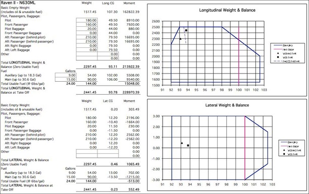
A weight and balance calculation includes a bunch of very large numbers that are subsequently divided to make much smaller numbers. The result is plotted on a graph surrounded by boundaries often called an envelope. The goal is for the plotted points and the line often drawn between them to be within the envelope.

Here’s what the W&B calculations and envelopes look like for the charter flight with Joe’s party with 1/2 tanks of fuel on board:

Weight & Balance

Note that the plotted square and triangle are within the envelope for both Longitudinal and Lateral Weight and Balance. I can look at these two graphs and see that based on how I’ve seated the passengers, we’ll be a little heavy in front and on the pilot’s side. But the weight distribution is within the range my aircraft and its controls can handle.

It’s Not a Time to Be Vain

Weight and age are the two things people are least likely to be truthful about. As a pilot, I don’t care how old you are — I’ve flown with passengers aged 6 months up to 95 years — but I do care how much you weigh. Lying is not in your best interest at all.

But because I assume people will lie, I automatically add 10 pounds to each passenger’s stated weight when calculating my W&B. So here’s the revised W&B looks like for Joe’s party:

Weight and Balance

Now we’re starting to get closer to the limits. The weight is way up front now — almost at my limit. Still okay to fly, still legal. But I know that there’s very little wiggle room.

I know from experience that I can make the situation better by putting a lighter person up front. So maybe I’d put Sally in the seat beside me. Here’s what that looks like:

Weight and Balance

That looks a lot better. See how the two boxes in the top graph have shifted to the right? That means the weight is shifted aft. More balanced.

But I also know from experience that some men are unlikely to take a back seat to their wives. And I know that big guys don’t fit very well in the back seat of my helicopter. There was a pretty good chance that the guy who’d booked the flight and was paying for it would not sit in the back.

Getting it Wrong Can Make it Dangerous

Unfortunately, not everyone underestimates weight by just a pound or two. Sometimes, they’re very wrong. Consider Joe’s party. Turns out that they’d underestimated weights by at about 20 pounds per person. Now my W&B calculation looks like this:

Weight and Balance

Ouch. As you can see here, the two plotted points on the top graph are just outside the envelope for forward CG. That means that the aircraft would be too nose-heavy for safe flight.

How could I fix the problem? Again, I could shuffle around the passengers, putting the lightest one up front. I could take the contents of the pilot’s baggage compartment and shift it to the baggage compartment for one of the back seats — or leave it behind. Loading less fuel would not help — although it would reduce the weight of the aircraft (and the endurance time), it wouldn’t resolve the CG issue.

How do I know all this? By playing what-if with my Excel spreadsheet and observing the results.

Don’t Lie to Your Pilot

What bothers me sometimes is the flippant attitude some passengers have about weight. These people were a good example. The man who booked the flight didn’t take any of it seriously. He just threw some numbers at me to answer my question. I could tell when I laid eyes on them that they were heavier than reported. One passenger confirmed his weight at 220; the other passenger’s wife confirmed his weight at 220. 20 pounds is not a small error. It’s 10%.

In this case, it was the difference between a safe flight and a potentially unsafe one.

What they don’t realize is that underestimating or just plain lying about weights can make a flight dangerous. They can put their lives at risk by providing incorrect information. Is it worth it? Just so a stranger thinks you weigh less than you really do?

I don’t think so.

[Another] Predawn Flight to Scottsdale

Flying before the day begins.

I had an early flight in Scottsdale yesterday. Three passengers wanted a custom tour of the Phoenix area.

The man who booked it kept asking to do it earlier and earlier. First 8 AM. Then 7:30 AM. Then 7:00 AM. And then 6:30 AM. “We’ll meet you at 6:15 AM,” he finally said. “Will the pilot be ready to fly right away?”

I assured him that the pilot would be ready to fly within 10 minutes of meeting them. I didn’t mention that the pilot would be me. I hung up, glad he hadn’t shifted the flight another fifteen minutes earlier.

The helicopter was in Wickenburg. Although I’ve been storing it in Deer Valley for most of this season, I took the month of March off. There were a few reasons for it, including two trips (that were eventually postponed). So I had to fly the helicopter down to Scottsdale from Wickenburg — a 35-minute flight — before meeting the clients. When I calculated my departure time, I realized I’d have to leave my house by 5:00 AM to make it on time.

I set my alarm for 4:20 AM. I woke up at 3:30 AM. I showered and thoroughly enjoyed a cup of coffee with Alex the Bird and Jack the Dog. Then I packed up my laptop and flight manifest, shut off the lights, and stepped out to start my day.

It was dark outside. The moon had set, but I could see stars. That meant it was clear. The weather forecast looked as good as it usually does, so I wasn’t expecting any difficulties on the flight. The only questions were about the client: Had he lied about the weights of the passengers? Would he really give me 90 minutes of flight time, making the trip worthwhile? (He wasn’t paying for my ferry time, so a short flight would make the trip a loss.) Would he really be at the airport by 6:15?

I drove to the airport in my Ford truck, passing just a few cars and trucks along the way. The green-white-green-white sweep of the rotating beacon cut through the night as I pulled into the drive. I paused long enough to enter a combination on a keypad and wait while the metal gate rolled aside with a beep-beep-beep. Then I steered the truck down the asphalt drive, turned into the first row of hangars, made a broad U-turn, and parked in front of my hangar’s left door, with my headlights facing out. Even though the motion-sensor lights we’d installed over the hangar door went on, I’d need my truck’s headlights to see the combination on the padlock that secured the hangar. Once unlocked, I rolled the right door all the way open on the track and flicked on the lights. The big box hangar filled with light and the steady hum of the overhead fluorescents. I killed the lights on my truck before they killed the battery.

I’d done most of my preflight the afternoon before, after washing the helicopter and putting it away. I’d debated leaving it out overnight, but decided against it in case the client cancelled at the last minute. If I’d left it out, it would have saved me 15 minutes of time that morning. Instead, I had to use the ground handling equipment — a golf cart, a tow bar, and a set of ground handling wheels — to get the helicopter out onto the ramp. I backed the golf cart out of the hangar, towing the helicopter out nose first. Then I turned off the lights in the hangar and rolled the big door shut, securing it with the padlock again.

It was quiet and dark as I backed the cart out onto the ramp. Some of the overhead lights out on the ramp don’t work. It didn’t matter much to me — I wouldn’t park under any of them anyway. I needed room for my rotors to spin; it simply didn’t make sense to park next to a pole. But the ramp was too dark to see what I was doing. I had to turn on the golf cart’s headlights to unhook the tow bar. I’d never used them before and was rather surprised to find that they worked.

With the ground handling equipment out of the way, I climbed into the cockpit and went through my startup procedure. It took two tries to start the engine; not enough priming the first time for the cold. The engine roared to life and I flicked the appropriate switches to get the blades turning, battery charging, and radios working. I clearly heard the relatively high-pitched whine the engine — or something else back there — makes when it’s cold out. I knew from experience that the sound would go away as the engine warmed up. I turned on the navigation lights, which also illuminated the instruments. The green position light beneath my door reflected in the dusty surface of my side window.

I plugged my iPod into the intercom system. I’d listen to music on the way down.

It took a long time for the engine to warm up. While I waited, the guy in the hangar across from mine drove up and parked in front of his hangar. It was 5:30 in the morning — a full hour before sunrise — and the guy didn’t have a plane. What the hell was he doing there? He spent more time at the airport than most aircraft owners did, usually just sitting in his truck and talking on the phone. It creeped me out.

When the cylinder head temperature had sufficiently warmed, I did my mag check and needle split. I loosened the frictions and brought the engine and rotor RPM up to 102%. I was ready to go.

It was still very dark.

I made my radio call: “Wickenburg traffic, helicopter Six-Three-Zero-Mike-Lima is on the ramp, departing to the southeast.” I flicked on my landing lights, surprised, as always, by the sudden glow and the brightness of the dust particles swirling around in my downwash. Then I lifted into a hover, used the pedals to point the nose at the taxiway, and eased forward, climbing gently. When I reached the taxiway, now eight feet off the ground, I banked right and followed the pavement on a heading of 50°.

Wickenburg at Night

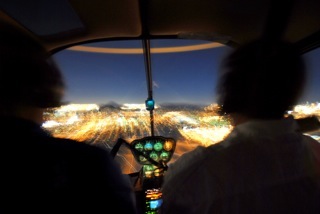
This photo by Jon Davison of us landing at Wickenburg at night gives you an idea of what the view from the cockpit looks like with the runway lights on.

The landing light shined down on the taxiway and out ahead of me as I gathered speed and altitude. I was about a quarter of the way down the taxiway when I realized I’d neglected to turn on the runway lights. I pressed the mic switch seven times. Nothing happened. I tried again, more slowly. The runway lights came to life: two strands of glistening white pearls turning to orange and then to red as they receded into the distance. The taxiway lights, glowed blue in a pair of light strings to their right beneath me. Beyond them was the dark void of empty desert and the greedy dreams of a failed real estate project. Aligning myself with the taxiway lights, I climbed out into the night. I flicked the switch to kill the landing lights.

The lights of Wickenburg spread out before me like a handful of gems cast into the desert by a giant. As I gained altitude to clear the invisible mountains just south of the town’s center, the distant glow of the Phoenix area came into view on the horizon, blocked here and there by the dark shapes of mountains that lay between me and the city beyond. I continued to climb. My goal would be to clear all those little mountains so I wouldn’t have to worry about hitting them in the dark.

I’ve flown the route between Wickenburg and Scottsdale many times. I even flew it at least one other time before dawn. But this time, I was tuned in to the darkness and silence of the night. I pressed the play switch on my iPod, letting some classic rock accompany the steady hum of my engine and the beat of my rotor blades. I climbed to 4,000 feet MSL — more than fifteen hundred feet over the desert below me — and leveled out. I was clear of all mountains between me and my destination.

Once away from Wickenburg, below me was only the darkness of the empty desert. With no moon, there was barely enough starlight to make out the meandering lines of dry washes and the occasional dirt road. Without visual landmarks, I realized I didn’t know where I was. Was that the Santo Dominguez Wash? Or one of the lesser washes in the area? And how about those lights to the left? Campers? Or that ranch off Constellation Road, viewed from a different angle? Only my GPS and the view of Phoenix’s lights spread out in the distance before me assured me that I was heading in the right direction.

The sky brightened ever so slightly as I glided southeast. The air was calm and smooth; my helicopter could have been a skiff floating on glassy water. I crossed over a well-defined dirt road that had to be Castle Hot Springs Road. Then I recognized the lights of the Quintero golf course and vehicles on Carefree Highway. The brightening sky reflected in Lake Pleasant, far to my left.

After ten minutes of flying over empty desert, I was returning to civilization: the northern reaches of Peoria.

I descended through 3500 feet, feeling ridiculously high above the ground as the glow from lights below me started reflecting in the inside of my cockpit bubble. I turned up the brightness on my instrument lights just a bit. Still descending, I flicked the radio to listen to the ATIS at Deer Valley. It was 5:50 AM and the tower was still closed. The automated weather observation system reported calm winds and an altimeter setting of 30.04. I adjusted my altimeter while listening to the recorded voice of the controller who’d closed the tower the night before. The tower would open at 6 AM. I wondered whether I’d reach the airport before then. I tuned the radio to the common traffic advisory frequency for Deer Valley, made a radio call with my position ten miles out, and continued on a course that would take me right over the top.

Lights at Night

The lights of the Phoenix area, at night. Photo by Jon Davison.

To the south, the brightness of lights on the ground intensified. The area was packed with new subdivisions, some completed before the housing bubble burst while others still had empty, weed-filled lots beneath their street lamps. It was a sharp contrast to the empty desert I’d been flying over for most of the trip. It amazed me that people wanted to live like that — packed like sardines into bulldozer-groomed lots — when there was so much beautiful desert, with rolling hills, cactus, and natural landscaping only a half mile away. The wide open spaces are what drew us to Wickenburg in 1997, but even that small town wasn’t immune to the greed of developers. Town planning restrictions were overturned on a case-by-case basis — often against voter’s wishes — for favored developers, resulting in smaller and smaller lots. Land zoned as horse property was rezoned to keep horses out and make lots too small to have them anyway. The retirees bought second homes in town to escape the cold of the midwest, doubling the population — for half the year, anyway. A friendly little western town turned into a retirement community right before our eyes. All of our young friends moved on to places like Colorado and New Mexico and California, leaving us with the retirees.

But I’m not ready to retire from life.

I descended to 2500 feet — a good 500 feet above where I normally flight during daylight hours — and leveled off. At five miles out, I made another call to Deer Valley traffic. I was now crossing into Deer Valley’s airspace; if the Tower had been occupied, I’d have to establish radio communication with the controller. I was the only one on the radio though — no one else spoke up. I crossed over the Central Arizona Project (CAP) canal where it meets the I-17 freeway. The sky, now quite bright, reflected in its smooth waters, drawing a bright line to the southeast.

Two miles from Deer Valley, I made another position call. No answer. I was close enough to see the tower; there was some light up there. Towers are normally kept dark so the controllers can see outside without bothersome reflections. A moment later, the airport’s two runways stretched out below me. I didn’t bother turning on the lights; I wasn’t landing and didn’t need them. But I could still see them quite clearly in the predawn light. It was about 5:58 AM and I expected the tower to open at any minute. I used the radio to announce that I was over the top and transitioning to Scottsdale. No answer. I glided on my way, descending down to 2300 feet.

Horizon

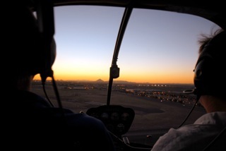
In this last shot by Jon Davison, you get an idea of how the horizon looks before dawn. (This shot was actually taken after sunset.)

Now the lights were bright below me as I flew over one subdivision after another. I crossed the Loop 101 freeway. Ahead of me, I could see the rotating beacon at Scottsdale Airport, about 12 miles away. The black bulk of the mountains on the horizon were well defined with sharp edges against the bright sky. Four Peaks was clearly identifiable by its four individual peaks.

I used my second radio to listen to Scottsdale’s ATIS while remaining tuned into Deer Valley. That airport was still closed, too. The automated weather system reported light winds and an altimeter setting just a few hundredths off from Deer Valley’s. The recorded controller’s voice warned of an unlighted 150-foot construction crane and advised that the tower would open at 6 AM. I flicked the recording off.

Now I was wondering about my client again, wondering whether he’d show up on time, whether he’d lied about his weight, whether he’d give me more than the 90 minutes of flight time he promised. I’d know soon enough.

The sound of a telephone dial tone came through the radio in three short bursts. Then the Deer Valley controller came on. He sounded tired and depressed, as if he’d just woken up to bad news, as he read the standard tower opening statement over the radio. It was long. I was still in his airspace, so I listened. At the end, he said, “Helicopter Zero-Mike-Lima, traffic ahead and to your left is a helicopter at twenty-five hundred feet. Frequency change approved.”

I’d already seen the helicopter flying west along the north side of the Loop 101. I replied: “Zero-Mike-Lima has that traffic in sight. Changing frequencies. Have a good day.”

I switched over to Scottsdale tower with the flick of a button. A female controller with a bright, bubbly voice was giving instructions to a jet preparing to take off.

I waited until she was finished and the pilot had replied, then made my call: “Scottsdale Tower, helicopter Six-Three-Zero-Mike-Lima is seven to the west off Deer Valley landing at the terminal.”

“Helicopter Zero-Mike-Lima, proceed inbound, report a half mile west.”

“Will report a half mile west, Zero-Mike-Lima.”

I continued inbound, crossing over Route 51. The sky was much brighter now; dawn was only 30 minutes off. I continued my descent to 2000 feet, roughly 500 feet over the ground. I listened to the tower talk with a female airplane pilot with the call sign “Traffic Watch” and wondered what kind of traffic she could watch from an airplane. Maybe I’d misheard them. She was using Runway 3.

Then I was less than a mile out and ready to start my final approach. I reported my position and was cleared to land on the ramp with the usual “use caution; ramp uncontrolled” and “remain west of the runway and taxiway at all times.” I repeated the “remain west” restriction as I steered to the south, descending. When I was abeam the approach end of runway 3, I swung northeast and lined up with the ramp, parallel to runway 3 and the taxiway beside it. I came in behind all the jets parked on the ramp and hover-taxied beyond them to transient parking for small airplanes. I set down at the end of the “Reserved” row and started my shutdown procedure.

In front of me, the terminal’s empty windows reflected the bright glow of the predawn sky, along with the flash of my helicopter’s strobe light. It wasn’t night anymore, but it wasn’t really day, either. It was that in-between time, the time of day when you put the secrets of the dark night behind you and prepare to embrace the day. It’s a special time, a time that’s always calm, always reflective. A time that makes me feel good to be alive.

I shut down and went inside the terminal. It was 6:10 AM.

And in case you’re wondering, the passengers did show up, they lied by a total of 50 pounds about their weights, and they flew with me for a full two hours.