…in a beautiful place.
If you’ve been following this blog, you may have read about a gig I did a few months ago for a group of photographers at Lake Powell. You may also have seen the photo one of the photographers sent from our flight together.
This past weekend I did it again — in a big way. I made a total of five flights (over two days) with two or three photographers on board to photograph the lake and the surrounding area. And this time, the conditions were perfect, with constantly varying light and clouds.
It was hard work in a beautiful place.

Lake Powell in the morning.
It was hard work to meet some of the photographers’ demands. I did a huge amount of out-of-ground effect hovering at altitudes as high as 7,000 feet with as many as four people on board. Although I don’t have my helicopter’s performance charts memorized, I do know approximately what’s possible when the helicopter is flown by a test pilot with thousands of hours. I am not a test pilot and I don’t have thousands of hours. So when I was able to hold those high hovers for a few minutes at a time — just long enough to take the shots — I was pretty surprised.

Rainbow Bridge.
I did get into settling with power conditions on three occasions. In two of them, I caught it quickly, said “Gotta go,” into the intercom, and pulled out of it before the descent rate got out of hand. But on one occasion, the descent rate got to 700 fpm before I attempted a recovery and it got all the way up to 1,500 fpm. (It was just like a training exercise, when you purposely let things get bad before you recover.) We were very high over the Colorado River at the time and there weren’t any other aircraft around, so it wasn’t a dangerous situation once I started recovery. But it was a bit unsettling, at least for me. My passengers had no clue that we were dropping out of the sky, despite those vibrations that tipped me off. On subsequent flights, I was a bit more careful not to get into that situation and I refused to hover in locations where we were too close to earth for a recovery if one was needed.
One of my passengers was extremely demanding and often required high hovers. He’d say “Stop in this place,” expecting me to somehow drop from 80 knots to a standstill 2,000 feet over the lake and turn the helicopter to the exact heading he needed to frame his shots. I say shots because this photographer liked to take multiple images that he could stitch together in his computer to make one big image. It was important that I didn’t move while he was snapping away. Unfortunately, he usually started snapping before I was at a complete stop. I’d be all set up for him to start when he was finished. Later this week, when he gets into his digital darkroom, he’ll see the movement in the shots because the stitching won’t work and he’ll blame me for moving. Go figure.
Fortunately, most of the others were satisfied with me slowing down and circling certain areas.
Reflection Canyon on Lake Powell.
Another challenge of these flights was the tour airplane traffic. On my last gig at the lake, we’d been the only aircraft over the lake. But this time, the tour planes were flying. And they didn’t fly alone. They’d take off in packs, following a set route I didn’t know, using reporting points that were only vaguely familiar. Worst of all, they were flying right around my altitude, 5500 to 6000 feet. After my first two flights, I chatted with one of the pilots to establish things like flight altitudes, route, and reporting frequency for uplake activities. I felt better about it then. But every time a pack of them would take off from Page, I’d do my best to be out of their way.
At one point, we were at the dam taking pictures at about 5200 feet when the planes launched. The dam was the first reporting point on their route and they usually were flying at about 5,000 feet when they got there. I listened as about five of them took off. My boss passenger was fine-tuning my position in the sky over the lake near the dam and all I could think about was the planes coming my way. They would pass me on their way to Horseshoe Bend and pass me again on their way from there to the Marina. That’s ten possible conflicts. I reported my position and kept a lookout, but when one plane reported that he saw me and I saw him take what looked like evasive action to avoid me, I told my passengers we were going to get out of the way until they were gone. I dropped down to 4,500 feet, which was only about 300 feet above the river’s cliff walls, and circled as they all headed to Horseshoe bend. Then I climbed through 6500 feet, which was above their altitude in that area and we resumed work. It was weird seeing one of the planes pass directly beneath me, about 700 feet down, as I slowly circled Horseshoe Bend.
Glen Canyon Dam.
All this time, my R44 Raven II performed flawlessly. I had climb rates of up to 800 fpm with four people on board. We were flying in the 5000+ feet neighborhood and it was about 80°F outside.
Each flight was about 90 minutes long. I’d load up enough fuel for a little over 2 hours to keep us as light as possible. On the one flight that I had only two passengers, I topped off the tanks. That flight went nearly 2 hours and was extremely strenuous — the boss passenger was the most demanding photographer. I didn’t realize it until after the flight, but I’d had a “death grip” around the cyclic and could barely open my hand when we landed. My whole right arm was stiff and my shoulder ached. I was so tensed up that it took a hot shower and good dose of ibuprofen to loosen me up.
The San Juan River near its confluence with the Colorado River on Lake Powell.
Mike, who’d accompanied me to Page for the weekend, spent the time hanging around the marina and hotel, walking around, swimming, and watching them put giant houseboats in the water. He couldn’t understand why I was so tired at the end of each pair of flights. To him, I was just flying around. But I really was working hard.
Wahweap Marina on Lake Powell.
At the end of the two days and five flights, I had over 11 hours of billable time. The resulting revenue stream is enough to cover all of Flying M Air’s fixed expenses for two months. So I’m not complaining about hard work. It was worth it and I’d certainly do it again.
But the most frustrating thing about the weekend was the missed opportunities for taking amazing photos. Although I don’t consider myself a great photographer, I don’t think I’m a bad one. But I was flying and needed both hands to do my job for most of each flight. Taking photos was out of the question. It was killing me to see all this great scenery and not be able to capture my own images.
So on Sunday morning, when we left Page, we flew uplake with Mike’s door off. He took the photos you see here in this entry. I’ll be using some of them to illustrate the area on Flying M Air’s Web site for the Southwest Circle Helicopter Adventure excursion.
I can’t wait until he gets his helicopter rating so he can fly while I snap the photos.
 It was autumn — third week in September, to be exact — and the aspen trees on the Kaibab Plateau were turning color. Aspens turn yellow in the fall and this shot shows them interspersed with the ponderosa pines that also grow there.


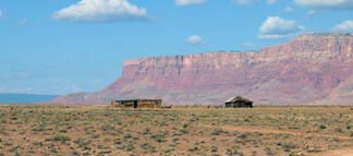 On the second day of the trip, I left Page and headed out toward Marble Canyon on the Colorado River, just downstream from the Glen Canyon Dam. It was early morning and the sun was casting a golden light over the landscape. I saw this abandoned Navajo homestead on the west side of the road with the Vermilion Cliffs in the background. It was a really beautiful sight, one certainly worth a photograph.
 Anyway, Havasu is famous for its waterfalls. The most famous is Havasu Falls, but there’s also Navajo Falls (upstream) and Mooney Falls (downstream, named for a guy who died trying to descend them). I don’t have pictures of any of the falls in the header of this site because falls are vertical and this header needs horizontal shots. So I have this shot, taken near our campsite on Havasu Creek.
 A few months ago, I started thinking about how cool it would be to have a computer conference here in Wickenburg, at my favorite guest ranch:
  So rather than give up the whole thing, I decided to restructure the event. I shortened it from five days to four. I cut the speakers from five to one. I cut the sessions from 12 to just two and made them more discussion based, giving all the participants a chance to share what they knew and ask everyone questions. I arranged the activities so all participants could go together, giving everyone an opportunity to network like crazy outside the meeting rooms. Then, with greatly reduced costs, I recalculated the per-person cost. The numbers I came up with were certainly within reason for a 4-day, all inclusive weekend at a luxury dude ranch.
 Mac Cowboys is a mini-vacation first: a four-day, three-night stay with luxury accommodations at a ranch that can only accommodate about a hundred and fifty people at once. You get yourself to Phoenix Sky Harbor airport or Wickenburg and just about everything else is paid for — ground transportation to and from the ranch, hotel room, three meals a day, horseback riding, golf, Jeep tour, helicopter tour, swimming, tennis, nature hikes — all kinds of activities. There’s even free wi-fi access in certain hotspots throughout the ranch. All you pay for is alcoholic beverages and extras like skeet shooting or golf cart or club rental.