A parting shot.
This short, unedited video clip was taken during departure from Marble Canyon Airport at the base of the Vermilion Cliffs in northern Arizona not long after sunrise.

A parting shot.
This short, unedited video clip was taken during departure from Marble Canyon Airport at the base of the Vermilion Cliffs in northern Arizona not long after sunrise.
And I thought February was bad.
March was likely the most hectic month I’ve had since I began freelancing back in 1990. It combined flying, travel, customer service, and the completion of a book in such a way that I was constantly busy and constantly thinking about what would come next. The month’s almost over now and I can look back at the craziness that was March 2011.
Those of you who know me or have been reading this blog for a while know that I wear two hats:
Juggling these two jobs has never been difficult. Writing gives me a huge amount of flexibility as far as time is concerned. I can usually put a writing project aside for a few hours or a day or even a few days to handle the demands of my flying business. After all, there never was much flying business — until recently.
And that brings us to March 2011.
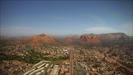
 The month started off with a bang. One, two, three: three days, three charters. I took a couple on a Moonlight Dinner Tour on Tuesday, took three people to the Las Vegas area and back on Wednesday, and took another couple to Sedona for a few hours on Thursday. That’s 8.9 hours of flight time in three days.
(Okay, so I know that I used to fly a lot more when I was a tour pilot at the Grand Canyon. But this is different. These flights are for my company, not some humongous tour operator serving busloads — no exaggeration there — of people daily.)
 I changed gears the following week and spent a good portion of the next two weeks conducting wildlife surveys for a client in various locations throughout Arizona and New Mexico. Not only did this require me to do about 40 hours of seriously intense flying in a relatively short period of time, but I also spent four nights away from home.
In the middle of all that, I had to arrange for some minor maintenance for the helicopter — I was quickly approaching my 50-hour required oil change. I’m still amazed that I managed to pull that together as quickly as I did. Many thanks to my now-retired local mechanic, Ed, for taking care of it for me.
Also on my calendar for the month — booked months ago — was a custom 8-day version of Flying M Air’s Southwest Circle Helicopter Adventure. I don’t do these trips very often — they’re costly and not everyone understands the value of what the package price includes — but it’s become almost routine, with me using the same hotels and tour operators and flying the same routes each time.
 The emphasis this time around was on “adventure” in that the weather really messed with us. Not only did we get snowed in at the Grand Canyon, but high winds made flying conditions less than ideal. It was extremely stressful for me; these folks had paid a lot of money for a trip and it was my job to make sure they were happy. Worse yet, to make up for scenery missed when I had to reposition the helicopter without my passengers on board, I had to fiddle around with the routes a bit to make sure we overflew certain terrain. And then there were doors-off photo flights as part of the trip; that wouldn’t have been so bad if it weren’t so darn cold.
In the end, I wound up flying more than 10 hours, driving more than six hours, and spending seven nights in various hotels all over northern Arizona. All while stressed out. Exhausting.
 I did, however, get a chance to fly down to Marble Canyon at dawn for breakfast with a friend. Shot some nice video along the way. I’m working on another video with the 10+ hours of “nosecam” footage I shot that week.
In case you’re wondering, I flew a total of 76 hours in March. To give you an idea of just how much that is for me and my business, for the past six years, I’ve flown only about 200 hours per year.
So in one month, I flew more than 1/3 of the hours I fly in an entire year.
That’s just the flying side of things. I was also chest deep in a new book for a publisher I haven’t worked with before.
I don’t want to go into details about the book. I’ll just say that the experience was not ideal for me — and likely not for the publisher, either. The trouble is, the book seemed to drag on and on. Normally, I can knock off a new book in a month or so with constant pressure and support from my editor. This book…well, we’ll just say that no one seemed to be too interested in me finishing it up.
Until March.
That’s when someone pulled the project off the back burner and turned up the heat. I had to finish writing a chapter or two, then start reviewing edits and proofs. And revising screenshots — let’s not go there, okay?
Trouble is, I needed to do this kind of work in my office and I was away from my office for about half the month. So the days I was in my office, I was working my butt off on this book.
Yesterday, I reviewed the last of the first-round proofs. The book looks remarkably good and I’m more proud of it than I should be. But they tell me there’s a second round of proofs to come. How can I politely tell them that I’m sick of looking at it? Answer: I can’t.
So far, my April calendar looks refreshingly open. I have another short wildlife survey, two moonlight dinner tours, and a multi-day photo flight with a regular client. I have two book projects to start — one brand new, one a revision. And that’s it.
In May, I have another wildlife survey flight that’ll likely go two or three days and then a week at Lynda.com to record a course revision. And then, at month end, I move up to the Pacific Northwest for the summer.
The month of March left me exhausted and I’m glad its over. I wish I’d been busy like this 5 or 10 years ago. Now that I’m getting older, I’m really feeling the impact of hard work and long hours flying or in front of a computer. It’s great for my businesses, but difficult for me.
Anyway, this should give you an idea of why my blog posts have been in short supply. I’ll try to start writing more regularly again soon.
A quickie video.
A helicopter flight from Page, AZ to Marble Canyon, AZ revealed first light on the aptly named Vermilion Cliffs. Excellent footage of Marble Canyon and the historic Navajo Bridge. Shot with a GoPro Hero video camera mounted on a Robinson R44 Raven II helicopter.
A true story.
“Can you help me…with some food?”
The query came from a Navajo woman with a cane in the Safeway supermarket parking lot in Page, AZ. I was just walking up to my rental car when she came up to me.
I thought for only a moment. “Sure. What would you like?”
“Taco Bell.”
The Taco Bell was just down the street. “I’ll take you there,” I told her. “Hop in.”
She walked around to the other side of the car while I climbed in my side. I put my Starbucks latte in the cup holder and tossed the lemon coffee cake I’d bought onto the dashboard. I had some things on the passenger seat and moved them for her. Then she climbed in, putting her cane between her legs and shut the door. She was conservatively dressed, looked clean, and didn’t appear (or smell) drunk. She had a round face with flattened features and half-opened eyelids. She looked almost Asian. I remembered that the Navajo were descended from the people who had crossed the Bering Strait into North America in prehistoric times. She looked to be in her sixties.
I started toward Taco Bell. It was 9:40 AM. “It’s not even 10 o’clock. Do you think it’s open?” I asked.
“No. I don’t think so,” she replied thoughtfully. “It’s open until 11 at night.”
“How about McDonald’s?” I suggested. “They make a good breakfast.”
“Okay.”
McDonalds was down off the mesa on Route 89, about 2 miles away. I started down the hill.
“Do you work for a hotel?” she asked me. She’d obviously seen my rack cards, which I’d be bringing to the airport the next day.
“No,” I replied. “I work for a tour company.”
“Where are you from?”
“The Phoenix area,” I told her. “Wickenburg.”
“Oh, I know Wickenburg,” she replied. “I used to live in Glendale. Peoria, El Mirage.” She thought for little while and added, “I moved there when my husband died. Now I’m just homeless.”
I steered us down the hill. Lake Powell and the Glen Canyon Dam came into view.
“Can’t they help you at the Chapter House?” I asked. It didn’t seem right that the Navajo people would let one of their own remain homeless on the streets of Page.
“No, they can’t help me.”
The conversation died as we rolled down the hill. I suspected she wasn’t telling me everything. She was too clean and well kept to be truly homeless. She must be going somewhere at night.
“Do you have family in Page?” I asked her as I made the left turn onto Route 89.
“I have a son in Salt Lake City and another one in Phoenix,” she replied.
The conversation died again. This time she revived it.
“I heard that Chinatown got wiped out.”
I made her repeat what she said; I didn’t think I’d heard it right the first time. But I had.
“Chinatown?” I repeated. There was no Chinatown within 500 miles of Page, AZ. “I don’t know what you mean.”
“I heard it on the news.”
It came to me suddenly. “Oh, you mean Japan. The earthquake and tsunami.”
“Yeah, that’s it.”
By this time, McDonald’s was in sight.
“Can we go to Burger King instead?” she asked.
I saw the Burger King logo just up ahead. “Sure. You like that better?”
“Yes. They have a good deal. Two hamburgers for three dollars.”
I pulled up to the drive through at Burger King. The menu was on a board beside the talking box. “What do you want?”
“Two hamburgers,” she said. I think she was trying to save me money.
“Some orange juice to go with that?” I asked. I was thinking about getting something healthy into her.
“Yeah.”
“Anything else? Some fries?”
“No fries.” She was reading the menu board. “Maybe the sausage, egg, and biscuit,” she said suddenly.
“Okay. And two hamburgers for later?”
“Yeah.”
After what seemed like eternity, a voice came through the speaker. I ordered the sausage, egg, and biscuit breakfast meal and two hamburgers. The order taker asked if I wanted coffee or orange juice with that. I asked my companion.
“Orange juice.”
The order taker read back our order. It came to seven dollars and change. She told us to pull up to the second window.
At the window, the order taker took my money and gave us the orange juice and a straw. Then she asked us to pull up and wait in the parking lot while they made the burgers. Because it was so early, they’d have to be made special. So I pulled around to the parking lot.
While we were waiting there, I asked, “Why did you come back here from Phoenix?”
“I wanted to come back to my reservation,” she said. After a while, she added, “My mother and father live here.”
“Do they live far from Page?”
“Yes. Very far. Thirty-six miles. You go down Haul Road and then you keep going.” She added the name of the town but I didn’t catch it. Later, I found Kaibito on Route 98 36.9 miles from Page in the right general direction.
“Maybe you should go live with them for a while,” I suggested.
“I been thinking about it.”
“I think it’s a good idea,” I said honestly. I hesitated, then asked: “Do you need someone to drive you there?” I would have done it to get her off the street. My morning was wide open.
“No,” she replied. “I can hitchhike.”
I knew that hitchhiking was a popular means of transportation among Navajo people on the Reservation. I’d picked up a hitchhiker once myself, when I was driving through the Rez with some friends. She’d be okay.
The order taker came out with her food and I handed it over. I backed out of my parking space and prepared to take her back up into town.
“Can you drop me off at McDonald’s?” she asked.
McDonalds was just down the road, near the Wal-Mart. “Sure.” I drove over and made the turn. “Where? Here or near Wal-Mart?”
“Here,” she said. “By the tables.” McDonald’s had some outdoor tables in the sun. “I can sit and eat here.”
“Okay.” I drove over to the tables and stopped. For a moment, she struggled with her bag of food, orange juice, and cane. Then she managed to get the door open.
“Do you think you can help me with some money?”
I was wondering if she’d ask and was prepared. I handed her a $10 bill. “Here you go. Use it to get something good for yourself.” I still wasn’t convinced that she didn’t have a drinking problem — alcohol is a major problem on the Rez. But I couldn’t say no. I have so much; she had to ask strangers for food.
She took the money. “Thank you.”
She got out of the car, closed the door, and stood still behind it. I shifted into drive and pulled away slowly. When I’d gone around the McDonald’s to the exit, I saw her sitting at the table with her breakfast and lunch.
I drove back to my hotel, just down the road.
Weather. Again.
This week, I’m on a Southwest Circle Helicopter Adventure with two very nice folks from California. Although this helicopter excursion normally runs 6 days and 5 nights, these folks expanded the trip to add 2 more days at Lake Powell.
The weather was an issue from Day 1, when we departed Phoenix Deer Valley Airport and headed north to Sedona. Although the forecast didn’t seem out of the ordinary — mild temperatures, light winds, clear skies — an odd white haze had settled over the Phoenix area, making visibility poor. It was like flying in Los Angeles. Ick.
 So instead of giving my guests their Phoenix Tour and heading up the Verde River on Day 1, we took a shorter route to Sedona that overflew Lake Pleasant and stayed within several miles of the I-17 corridor. I figured I’d save the scenic flight for when visibility was better. I also expected visibility to be better in the Sedona area and was very surprised that it was not.
Of course, I watch the weather closely on these trips. Heck, I seldom go for more than a few hours without checking the forecast for the next three days and destinations. That’s how I knew the wind would kick up at the Grand Canyon for Day 2 and likely keep blowing through Day 3.
 The flight to the Grand Canyon on Day 2 wasn’t anything special — except for that white haze that persisted, even up on the Coconino Plateau. Very odd for Arizona. It wasn’t blowing dust, either — the wind wasn’t strong enough for that. Just an ugly haze.
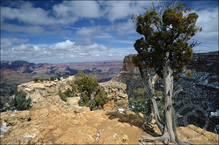
We got to the Grand Canyon in time for my guests’ helicopter tour with Maverick Helicopters. We then piled into my redneck truck, which lives at the Grand Canyon during the winter months, and went into the park. I set my guests free to enjoy their day at the South Rim and did my job: getting their luggage into their rooms. Then I relaxed in my own room. I’d been at the Grand Canyon so many times when the weather was so much better. I was tired and thought I’d take it easy for the rest of the day.
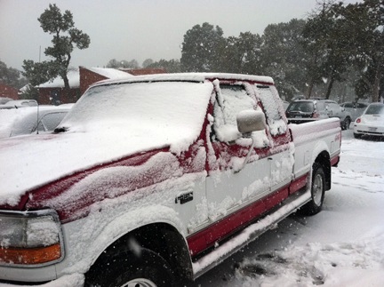
Of course, I still watched the weather. I wasn’t happy about what I saw for Day 3. Winds 25 gusting as high as 41 would make for a rough flight out of the area. And then there was the 90% chance of precipitation with 100% sky cover. The forecasters said to expect snow flurries with accumulations under 1 inch. This was a far call from the blizzard I’d experienced at Bryce Canyon the month before, so the snow didn’t worry me much. It was the cloud cover. I knew how low clouds could get at Grand Canyon Airport. If they came too low for a safe, VFR departure, we’d be stuck.
One of the drawbacks to scheduling a Southwest Circle excursion is that everything needs to be booked and paid for in advance. Last minute cancellations are not only costly, but they cause nightmares in merely making changes. For example, if we missed a Monument Valley date, we would likely not be able to stay there the next night — the place is booked months in advance. My guests were scheduled to take an Antelope Canyon Tour on Day 3 and a Lake Powell boat ride to Rainbow Bridge on Day 4. Although Antelope Canyon could likely be rescheduled, the boat trip could not. So weather delays cause nightmares for me during a trip. It’s for that reason that I usually can’t relax until we reach Monument Valley, normally on Day 4.
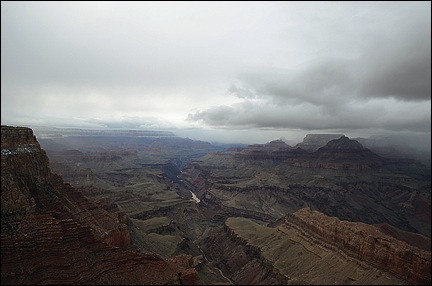
 Day 3 dawned gray but with plenty of visibility. I even got out and snapped a few photos when the sun poked through some clouds and illuminated one of the rock formations in the canyon near Bright Angel Lodge, where we were staying. I grabbed some coffee, went back to my room, and checked e-mail. An hour later, I peeked out the window and saw that it was snowing.
It was 7 AM. We were scheduled to leave at 9 AM.
Over the next hour, visibility dropped to near zero and the snow came down hard and fast.
After dealing with an almost flat tire on my redneck truck, I called my guests and told them we’d be delaying departure. I got their room checkout time extended to noon.
By 9 AM, it was pretty obvious that we weren’t going anywhere anytime soon. I shot this video outside the Bright Angel Lodge, right on the rim of the canyon. (I added the voiceover later that night.) Trouble was, I couldn’t extend our stay at the Canyon and I had all those other activities scheduled.
 I felt bad for my guests. They’d spent a lot of money on this trip and now they were stuck at a scenic place with no scenery and no helicopter flight to get them to their next destination. So I became their driver for the day. After realizing that the truck was not likely to make it to Desert View (on the east end of the park) before the roads were cleared, we stopped at the Visitor Center and the Geology Museum before heading into Tusayan (the tourist town outside the park) for lunch. The plan was for them to see the IMAX movie across the street next.
By 1 PM, the weather seemed to be clearing out. As we ate lunch at a “steakhouse,” I came up with a plan. While they were watching the movie, I’d prep the helicopter for departure. If the visibility held, we could escape to the east and arrive in Page before dark. (I’d already rescheduled their Antelope Canyon tour for Day 5.)
But that plan failed miserably. When I got to the airport, I found the helicopter’s right side — the side facing the weather — completely iced over. The main rotor hub, the tail cone, and the tail rotor were all coated with ice. Even the skids looked frozen to the ground. And, of course, there was a good helping of snow in the fan scroll (again!) and even some inside the air intake port. The temperature had dropped by 10°F and it was now below freezing. It would not warm up again that day. The helicopter was officially grounded.
 I wound up driving them to Page. The trip should have taken just over 2 hours, but since the weather was clearing enough to see into the canyon, we made several stops along the way. We arrived in Page at 8 PM. I checked them into their room, made sure they were set for the next day’s boat ride, and checked into my room at the Day’s Inn.
 Now what I needed was a thaw — temperatures above 32°F. I must have called the AWOS number for GCN a dozen times before 10:30 AM on Day 4. Then I climbed into my redneck truck and made the trek down to Grand Canyon Airport. It took 2 and a half hours with just one stop to snap pictures of a very different (from the previous day) view.
The temperature was about 36°F when I arrived at the airport. The sun — my friend! — was playing hide and seek with thick, layered clouds. But the tour operators were all flying — visibility was great! Even the wind was not a factor. Most of the ice on the outside of the helicopter had melted. I just had to resort to my hot water trick to melt all the snow out of the fan scroll. After a good preflight, I started it up. A little rough at first and it took a full 10 minutes to warm up. But then I was ready to go and, after getting clearance from Grand Canyon tower, took off and headed east.
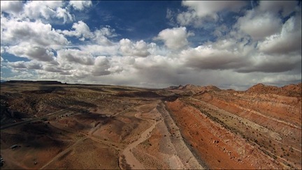 The flight was, for the most part, smooth. I ran the video camera (as you might expect) and captured some good footage over the Little Colorado River Gorge and along the Echo Cliffs. I set down on a helipad at Page Municipal Airport at 3 PM.
Today, the weather is clear with not a cloud in the sky. My guests are just finishing up their Antelope Canyon Tour. Tomorrow, we’ll continue on our way, winding up at Monument Valley in the early afternoon. So far, the forecast looks great.
Let’s hope it stays that way.