Remember the primary job of every pilot-in-command: fly the aircraft.
 Yesterday, I had a rather unusual charter for Flying M Air. I needed to take two men on an aerial survey of commercial properties throughout the Phoenix area.
A Full Workload
For two hours, we flew low (about 300 feet AGL) and slow (about 50 knots) over building rooftops. While this may have been too low to need to worry much about traffic, I did have to keep an eye out for obstacles, such as towers. And because some of these properties were within Class D and Class B airspace, I had a lot of radio work to do.
As you might imagine, I had a pretty serious workload.
Yet ten minutes into the flight, it appeared that my under-prepared clients expected me to know the street addresses of individual buildings that we flew over.
For those readers who are not pilots, I may need to point out that finding the street address of a building you’re flying over is not easy. The address is not painted on the roof. The street out front isn’t labeled on the pavement.
Yesterday, we covered an area 26 x 33 miles in size. That’s over 800 square miles. It would not be possible to know the names of every single street — and recognize them from the air! — in an area that size.
 Yet, believe it or not, I tried to accommodate them. I had my iPad with me and Foreflight software running. I had the Street Map displayed and was zoomed in far enough to read street names. When they asked, I attempted to read off the street name beneath us. I left it for them to try to get a number of the building. I did this for about 10 minutes.
And then I realized that what they wanted me to do was far beyond my duties as a pilot.
A Pilot’s Duty
Aviate, navigate, communicate. Those are my responsibilities, in the order of importance.
Aviate = Fly the aircraft. That means not only keep it in the air safely, but avoid hazards like other traffic and obstacles.
 Navigate = Go where you need to go. That means knowing where you are, where you need to go, and how to get there. It means following the instructions of air traffic control. In my situation, it also meant keeping track of the airspaces I needed to fly in: Deer Valley Class D, Scottsdale Class D, Phoenix Class B, Chandler Class D, Phoenix Class B (again), and Deer Valley Class D (again). Certain rules apply in these airspaces and I needed to abide by these rules so I needed to know when I was nearing or in these spaces.
Communicate = Talk to air traffic control or other aircraft. Communication is required in controlled airspaces. Not only did I have to talk to towers to legally enter their airspace, but I needed to tell them what I wanted to do while I was in there. I had to acknowledge and respond to their instructions and traffic advisories.
If any one or two of these duties had been light — for example, if we were cruising point to point at 100 knots 500 feet AGL instead of flying low and slow in an area with potential obstructions or if we were flying in the middle of nowhere where navigation and communication weren’t a factor — I may have been able to provide them with more of the information they wanted. But with the heavy workload I had to deal with, adding another complex task — one that clearly required me to remove a hand from the controls and eyes from outside the cockpit — was far more than I could handle safely.
Indeed, if I had continued to try to provide this additional information for them, I would have put our flight in danger.
I was smart enough to realize this and I simply stopped providing address information. Instead, I mentioned street names that I knew as we flew over them. I let them deal with figuring out where we were.
Pressure on the Pilot
You might wonder why I even tried to meet this client request. After all, it seems like a no brainer. I was pretty busy doing what had to be done. Why add more to my workload?
The answer is easy: pressure to please the client.
All pilots feel this pressure. The client is paying for a service. We feel a need to please that client by providing every bit of service he requests.
But this is wrong. So often, client requests are unreasonable or unsafe. The pilot-in-command is responsible for the safe operation of the flight. The pilot in command has the authority to say no to any request he or she thinks would jeopardize the safety of the flight — or, for that matter, get him or her in hot water with the FAA.
As the owner/operator of a charter business, I may feel more pressure than a pilot who has no real stake in the profitability of the business or the ability to get repeat customers. In other words, I may feel more pressure to make clients happy. But should I? Of course not! I need to be a pilot when I’m in the air. I can be a business owner when I’m on the ground.
Client Shortcomings
In all honesty, I was a bit peeved with the clients. These guys were almost completely unprepared. The only legible map they had of the survey areas was an image on an iPhone with limited scalability. They didn’t have a GPS. They didn’t even have a camera. Either tool would have helped them get the location information they needed on their own. I’ve taken plenty of survey clients out on flights in the past and they’ve always been very prepared to track their location and take notes along the way.
How could I have made the situation better? I could have told them point-blank that I would not be able to provide exact street addresses during the flight. I could have recommended that they get a street map that they could mark up while we flew. I could even have refused to depart unless they had the tools they needed to get locations on their own. But I didn’t do any of these things. I was on the ground, wearing my business owner hat after prepping the aircraft for a 2-hour charter that had already been paid for in full. I wanted to complete the flight.
To the clients’ credit, after I stopped providing street names, they didn’t press me for them. I think they realized that my hands were already full. They took some notes and spent a lot of time just looking. At the conclusion of the 2-hour flight, they seemed happy enough with the results.
But I know they could have gotten a lot more valuable information — and made the cost of the flight more worthwhile — if they’d been better prepared.
Two Points
There is a moral to this story. Two of them, in fact.
- A pilot needs to prioritize his workload in flight. The first three items must be aviate, navigate, and communicate. If doing all that doesn’t take up all of the pilot’s attention, additional tasks to meet passenger requests may be added.
- A client needs to be fully prepared for an aerial survey mission. That means coming with maps, GPSes, cameras, or any other equipment that will help him get his part of the mission done. In addition, he needs to communicate, in advance, with the pilot to learn about the limitations of the flight.
Sometimes, when I read accident reports, I wonder whether the accident was caused by a pilot doing something other than his primary duty of flying the aircraft. While it’s great to be able to meet all the needs of a paying passenger, conducting a safe flight and getting back to base in one piece is far more important.
I’d love to hear other stories about handling client requests beyond the call of duty. Use the comments link or form for this post.
 I admit I wasn’t looking forward to the gig. The two photographers claimed to weigh 242 pounds (converted from kilos) and I knew they likely weighed more fully dressed and carrying camera equipment. I calculated the weight and balance as soon as I had this information and discovered that I’d have to strip all non-essential equipment out of the helicopter to lighten it up so we could take enough fuel for 2 hour flight segments (plus FAA-required reserves). Anything that was left on board would have to be shifted from under my seat to under the seat behind me, just to shift weight backwards. Having two fatties — yes, including me — up front would make us front-heavy. Having two fatties on the left side would make us heavy on that side. But even after adding 15 pounds of weight for each of them, I confirmed that’d be in balance with 2/3 fuel or less on board.
 Using
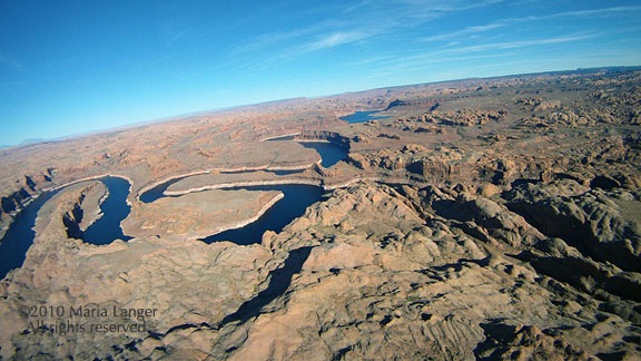
Using  What fascinated me was the way the light changed throughout the flight. At first, it was partly cloudy. Then the sun slipped behind the clouds and it was cloudy. Then the sun began to break through, speckling the mountainsides with light. This still image, captured from the video, gives you an idea of what I mean. The light changed numerous times over the two-hour period of the flight — at one point, clouding over completely only 1,000 feet above me — giving the illusion that the flight was conducted over multiple days.
 One of the highlights of the flight was crossing the red rock cliffs west of
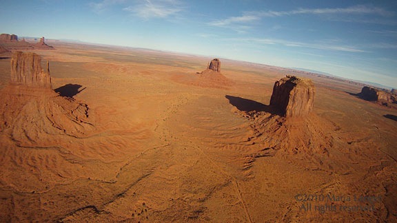
  When I got to the empty expanse of the Navajo Reservation, I dropped down and flew low over the ground. There were few homes in the hundreds of square miles and only a handful showed signs of life. In the video, my helicopter’s shadow is clearly visible: small when I’m flying higher and larger when I’m flying lower. The video makes it seem as if I’m going much faster during this portion of the flight, but I’m not. I managed to keep a steady 100-110 ground speed for most of the flight. It’s just an illusion: the closer the camera is to the ground, the faster I seem to be flying.