It’s included in the Track Progress service, so why not?
 I’ve been using a SPOT Personal Tracker for the past two years. It was recommended to me by a helicopter pilot friend. We both fly in remote areas — the kinds of places that if you go down, rescuers are probably not going to find you before it’s too late.
Think I’m kidding? Check out this Cessna, which was not located for 31 months. I was just one of dozens of local area pilots who looked for this plane whenever I was in the area where it disappeared.
And what pilot can forget the disappearance of Steve Fawcett? Millions of dollars and lots of high-tech search techniques were used to try to find his plane. Over a year passed before a hiker found Fawcett’s ID and the wreckage was eventually found.
I didn’t want to end up like either one of these unfortunate flights. Even if I suffered a fatal crash, I wanted to be found as soon as possible. And if I simply went down and needed help, I wanted help to be able to find me without relying on cell phone signals.
The SPOT Service
So I bought a SPOT Personal Tracker and subscribed to two services:
- Basic Service enables the SOS (AKA 911), Help, and Check-in/OK features of the unit. That requires a button push to send the message. This service costs $100/year and is required to use the device.
- Track Progress drops “breadcrumbs” of your location every 10 minutes so others can track you. The track progress feature automatically plots your location signals on a map that’s accessible online. You can create a shared page, give the URL to whoever you want, and let them track you. The benefit of this — as far as I’m concerned as a pilot — is that if I go down suddenly and am incapacitated, people tracking me will not only know where I was within the previous 10 minutes of my mishap, but they’ll likely know which way I was going. Plus, if the unit is intact, it will continue to broadcast my location every 10 minutes. This non-moving signal should help them pinpoint my location — even if I’m dead. This extra service costs $50/year. While I have another pilot friend with a SPOT who doesn’t use it, I think every pilot who uses this device should cough up the extra dough for this service. You can’t always press a button when you need help.
I need to stress here that this is not a device designed for aviation. It’s really designed for “adventure activities” or travel — for hikers and campers and mountain climbers and kayakers. For folks who get out in the wilderness. Of course, pilots who fly in remote areas can benefit from the device and there are plenty of stories of how it may have saved aviator lives. Just keep in mind that it is not an approved FAA tracking device and that flight plans should always be filed and opened for remote area flights. And, if you’re an airplane pilot who flies at altitudes where FSS Flight Following is possible, why not use that service? Unfortunately, Flight Following is not usually available at the altitudes at which I fly my helicopter.
Creating a Shared Page
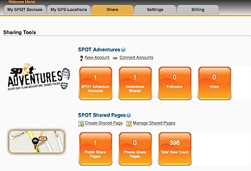
Of course, having a SPOT Personal Tracker with the Track Progress feature means a Share Page (example shown below) is included with your subscription fee. It makes sense to set up this page and share it’s URL with the folks who need to know where you are. You can also share it with the world at large if you’re like me and don’t care who knows where you are when you’re on the go.

Some recent activity; I did 20-minute helicopter rides the other day.
Setting up a SPOT shared page is easy. Assuming you’ve already set up your account on the SPOT Web site and have activated your device, just follow these steps:
- Sign into you account at FindMeSpot.com.
 Click the Share tab near the top of the page.
- Under SPOT Shared Pages, click the Create Shared Page link.
 Set the options in the Create Shared Page window that appears. Be sure to enter a Shared Page Name and select your SPOT device. Under Security, you can specify whether the page is Public or requires a Password to access. Personally, I recommend keeping it Public. You can always limit who you give the URL to. It would be terrible if someone needed to access the information and couldn’t remember the password.
- Select one of the options at the bottom of the page to determine how you’ll notify the people you want to share the page with about the page’s URL:
- If you select Send the shared page myself option (recommended), a message appears, telling you that anyone with the link can view your shared page. Click Create Now to complete the process.
- If you select Have SPOT send the shared page, a form appears for you to enter up to 50 e-mail addresses and create a custom e-mail message. Be sure to keep the Send a copy to you check box turned on so you get the URL, too. Click Send Now to complete the process.
 At the bottom of the page, a very long URL should appear. Triple-click it to select it and chose Edit > Copy (or press Command-C (Mac) or Control-C (Win)) to copy it to the clipboard. We’ll use it in a moment to test the link and create a short URL.
 If, for some reason, you didn’t get the URL or you need to access it again in the future, click the Shared tab (shown above) and then click the Manage Shared Pages link under SPOT Shared pages. You can click the name of the shared page to display it. You can then copy the link for that page from the Web browser’s address bar.
Creating a Short URL
http://share.findmespot.com/shared/faces/viewspots.jsp?glId=0aISLWHRq9KlETLqzcfFGQuD8VboS6R8O is not exactly the kind of URL that’s easy to share with friends. Fortunately, URL shortening services enable you to create a custom URL for any page. Although this step isn’t required, it’s certainly recommended.
Although I originally created my short URL with the TinyURL service, you can use any service you like. Bit.ly makes even shorter URLs, but it requires an account to create a customized one. So in this example, I’ll use TinyURL again.
- Point your browser to TinyURL.com.
 Paste the URL for your shared page in the top text box.
- Enter a short word or phrase that’s easy to remember in the bottom text box. In this example, I’ve entered the N-number for my helicopter. My original URL used FindMaria.
 Click Make TinyURL!
A message like the one shown here appears, confirming that the new URL was created. You can now give this much shorter URL to family and friends.
Share Your SPOT Page!
Are you already using a SPOT device? If you’ve got a page set up, share it here. Use the Comments link or form for this post. No need to enter any HTML tags; just enter the complete URL. Once your comment has been approved, your shared page will appear. I’d also love to hear comments about the device — good or bad.

 About a year and a half ago, I bought a Sony HDR-CX12 Handycam. It’s a mid-range consumer model that shoots in full 1080i HD. I bought it to fill in the gaps of the video needed to finish up a video project and, since then, have been using it on and off to shoot stock video footage. The quality of the video is amazing for such a compact and relatively inexpensive device. These days, you can get something even smaller and less costly that does the same thing.
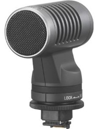 Of course, the camera is a consumer model and is extremely limited in compatible accessories. But today I poked around on the Sony Web site and tracked down a stereo microphone that might do the job — if I keep the camera out of the wind. It’s a Sony ECM-HST1 microphone, which fits into the camera’s hot shoe and draws power directly from the camera. It’s not what I really wanted — I wanted a lapel mic — but it’ll have to do.
 While I was surfing around for the best price, I stumbled upon this little gem: the Opteka OPT-SC37FE Ultra Fisheye Lens for Digital Video Camcorders. I already have a wide-angle lens for my camcorder, but there’s nothing like a very wide angle lens to get interesting effects or get up close and personal with your subject matter. The video clip on Opteka’s Web site certainly makes it look like a useful and fun accessory. Since I owed myself a birthday present anyway, I sprung for that, too.
 Click the Share tab near the top of the page.
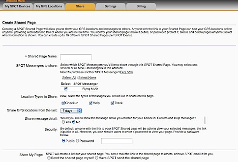 Set the options in the Create Shared Page window that appears. Be sure to enter a Shared Page Name and select your SPOT device. Under Security, you can specify whether the page is Public or requires a Password to access. Personally, I recommend keeping it Public. You can always limit who you give the URL to. It would be terrible if someone needed to access the information and couldn’t remember the password.
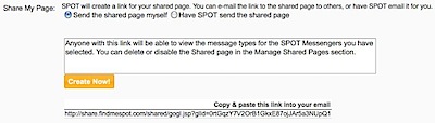 At the bottom of the page, a very long URL should appear. Triple-click it to select it and chose Edit > Copy (or press Command-C (Mac) or Control-C (Win)) to copy it to the clipboard. We’ll use it in a moment to test the link and create a short URL.
 If, for some reason, you didn’t get the URL or you need to access it again in the future, click the Shared tab (shown above) and then click the Manage Shared Pages link under SPOT Shared pages. You can click the name of the shared page to display it. You can then copy the link for that page from the Web browser’s address bar.
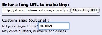 Paste the URL for your shared page in the top text box.
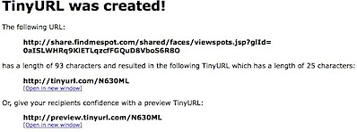 Click Make TinyURL!