The San Francisco Peaks

And Jack the Dog.

San Francisco PeaksI took this photo on the hiking trail to…well, I can’t remember the name of the place now. I think it’s called Red Mountain. It’s off route 180, between Valle and Flagstaff in northern Arizona.

The photo shows the San Francisco Peaks, which are the tallest peaks in Arizona. Mt. Humphreys is the main peak. There’s a ski resort up there that’s open in the winter when there’s enough snow. They want to use reclaimed water to make snow up there, but the Navajo indians are against it. You see, the San Francisco Peaks are one of the four sacred mountains of the Diné.

If you look closely, you should see Jack the Dog running towards the camera in the photo. Jack’s always running somewhere. He gets ahead of us on a hike and we call him back. We figure that he runs 2 to 3 times more on a hike than we walk. Ditto for horseback rides.

As for Red Mountain — if that’s what it’s really called — its an interesting spot at the end of an easy hike. It’s the remains of a volcanic mountain that collapsed years ago. Inside, past the lava, are hoodoos very much like you’d find at Bryce Canyon National Park. They’re even red like the ones at Bryce. There are trees in there and plenty of quiet places for a picnic lunch. Best of all, not many people know about it so it’s never crowded. I recommend it

Surprise Valley Drugs

One of my favorite shots from my August 2005 road trip.

Surprise Valley Drugs
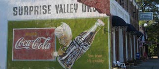
Yes, it’s the side of a building. But it’s also an old billboard for a drugstore that probably doesn’t even exist anymore. And there’s something about it that I really like.

I took this photo at the end of the second day of my trip. I was spending the night at Cedarville, CA, in a little motel on the edge of town. Cedarville was a quaint, undiscovered farming community. I’d passed at least a dozen huge California barns, hay fields, and horse pastures on the last half hour of my drive. I was exhausted and this quiet little town was like an oasis in the desert.

This billboard had been painted on the side of a row of shops. I don’t know how long ago it had been painted or whether the Surprise Valley Drug store was in Cedarville. But I snapped the photo to remember.

The next morning, after stopping back in town for a some car noshing supplies, I’d seen a similarly interesting shot across the street. But there were people out and about and I felt silly about taking the photo. Someday I’ll go back and snap it.

And to readers of my Maria’s Guides eBooks, if this looks familiar, it should. I used it for the cover of one of my eBooks.

Buy on RedBubbleThe full-frame version of this photo is available for sale as cards and prints at RedBubble.com

Crater Lake

The country’s deepest lake.

Although misnamed — it’s in a caldera, not a crater — Crater Lake in Oregon is among the most beautiful sights in the country. It also holds the honor of being the deepest, at over 1900 feet deep.

image

I visited Crater Lake for the second time in August 2005 during my 16-day road trip. Although I didn’t really have a reason to make the drive up to the lake, it wasn’t far off my path and it was certainly worth the drive. I had the ingredients of a picnic lunch with me and enjoyed it in the shade not far from the path along the caldera’s rim. Then I took a short hike around the main visitor area, which was being renovated.

I’ve been to the lake twice and both times it looked exactly the same. Crystal-clear blue water with a smooth, glassy surface, surrounded by mountains studded with tall pine trees. The water reflects the color of the sky, which always seems to be clear deep blue.

There are two islands in the lake — this one is called Wizard Island and it rises over 700 feet above the water’s surface. It was impossible, with my camera, to get a photo of the entire lake because it’s quite large — five to six miles wide. This shot came out best of the ten of so photos I took.

You can learn more about Crater Lake at the National Park Service’s Crater Lake Web site. I do recommend seeing it in person, though. It’s quite a treat and not nearly as crowded in the summer as some of the other National Parks.

Technorati Tags: , , ,

Oregon Coast…in Fog

Just after dawn at Fort Stevens State Park.

A lot of the photos in the header for this blog come from the 16-day road trip I took in August 2006. This is one of them.

I spent the night in a yurt at Ft. Stevens State Park on the northwestern tip of Oregon. In the morning, I went to the beach for sunrise. Unfortunately — or so I thought at the time — it was foggy. But when I did a little exploring around the deserted post-dawn park, I found some beautiful images that my little digital camera had no trouble capturing.

Oregon Coast in the FogThis dock stretches into a body of water not far from the coast. It was a haunting image, made magical by the reflections of the dock and grasses off the perfectly smooth water surface.

There was a fisherman there that morning, too, but we didn’t ruin the moment — or wonderful silence — with conversation. I moved around as quietly as I could, snapping photos here and there. He cast out his line, reeled it in, and casted it out again. After a while, I slipped back into my car and disappeared into the fog.

The next time I had Internet access, I sent the photos I took that morning to Mike via e-mail. He told me they were the best photos I’d taken so far on the trip.

The credit goes to the fog.

Oregon, coast, fog, Ft. Stevens State Park

Spirit Lake

At the foot of Mt. St. Helens.

Last August’s road trip took me as far north as Mount St. Helens. I was extremely disappointed by the way the U.S. Government has turned a natural disaster site into an income-producing tourist attraction that requires a special National Parks Pass or admission fee for entrance. (Odd that a pass that can get me into parks like the Grand Canyon, Yosemite, and Yellowstone won’t work at a volcano in Washington State.)

The last time Mike and I were at Mt. St. Helens was not long after its eruption back in the 1980s. The only approach to the site was from the southeast. So after taking a helicopter tour from the north side and being turned away at the visitor’s center, I drove around to the south side to see it the way I had years before, from Windy Ridge. Because there were no gift shops on that side, there weren’t many tourists and there were no rangers checking wrist bands. The experience was much more pleasant.

Spirit LakeI took this shot of Spirit Lake from the parking area. Logs still float on the lake, but the photo features a nice reflection of the mountain and sky. Mt. St. Helens is to the left, out of the photo. When the volcano erupted, the side of the mountain slid down into the lake as a blast leveled all the trees in every direction for miles around.

The volcano was smoking when I visited in August 2005. But the area all around was lush and green — quite a difference from the ash-covered landscape we’d seen years before. I made quite a few stops along the way to Windy Ridge, taking time for short hikes and photos.

If you ever get up that way, skip the Visitor Center and its “interpretations” on the north side. Come in from the southeast to Windy Ridge and see the sights without the tourists.

Mount St. Helens, volcano, Windy Ridge, Spirit Lake