More telemarketers, another rant, and the facts of my business life.
This morning, my phone rang with a call from Nevada. When I answered as I usually do — “Flying M, Maria speaking” — I heard an audible click when the caller hung up.
I called back. When a man’s voice answered with an uncertain “Hello,” I assumed I’d reached someone looking for a helicopter charter who, for some reason, had decided not to complete his call. But I was wrong. When I told him that he’d just called me and hung up, he explained that he thought he’d reached voicemail and then told me he was “with Google street view” and was in the area. He wanted to tell me about some services they offered. Apparently, the services were “virtual tours” that companies like Maverick had added to their Google Places page. They created these videos.
I seriously doubted that he was with Google. I had been called dozens of times in the past by people and recordings claiming they were with Google and promising to perform some service — for a fee, of course — that would put me at the top of the Google search listings and get me more business. These seemed like just another one — one with poorly trained staff, to boot.
I mentioned this to him. He assured me that they had a contract with Google.
“Is there a fee for this service?” I asked.
“Yes,” he admitted.
“I’m not interested,” I told him. “Thanks.” And then I hung up.
I added his phone number to my Telemarketers contact record, which has a silent ringtone. If he called back from the same number, my phone wouldn’t even ring.
The Boss Calls Back
Less than five minutes later, my phone rang again, this time with a different Nevada phone number. I answered the same way. This time, the caller claimed to be the owner of the business that I’d just spoken to, following up on a customer service email. He was apparently upset that I didn’t believe his company was with Google.
What followed was ten minutes of my life wasted by a man who seemed to think it vitally important that I believe his company had a contract with Google to update street view photos and create these virtual tour videos.
Frankly, I don’t know why I talked to him for so long. I had no intention of using his services, so it wasn’t just wasting my time but it was also wasting his. Maybe I felt sorry for him. Maybe I just didn’t want to be rude.
But one thing was clear: he had incorrect preconceived notions about my business.
You see, although he consistently referred to my company as a “helicopter company,” he also kept rattling off the names of big helicopter tour companies based in the Las Vegas area: Maverick, Papillon, etc. He went on and on about the importance of having an up-to-date street view image that would show the front of my building and my branding so people could find me. When I told him that 90% of my revenue came from agricultural work and not tours, he said, “It doesn’t have to be that way.” As if I was somehow missing out by not being primarily a tour operator.
I wanted to educate him, I wanted to explain the reality of my business model and why his services didn’t interest me. But he didn’t seem to care about what my business is. He was trying to cram my business into the small box in this mind where he thought all “helicopter businesses” should be.
So, in the end, I just let him talk himself out. When he’d run out of things to say and I didn’t respond by telling him he was right and that I needed his services, the call just kind of ended. I think I might have said, “Okay, thanks,” or something equally noncommittal. I think he may have said goodbye before hanging up.
Whatever.
The Reality of My Business Model
Flying M Air has been in existence since 2000. It’s been flying commercially since 2001, when I got my commercial helicopter pilot certificate. Back then, most of my business was short tours and photo flights falling under Part 91. In 2005, when I got my R44 helicopter and Part 135 certificate, I expanded to do longer tours, air-taxi flights, day trips, and multi-day excursions. Yes, the vast majority of my business was tour-related.
And my flying business was operating at a perpetual loss, funded by the money I earned as a writer.
In 2008 — not a moment too soon, since my writing income was quickly drying up — I discovered survey work. And cherry drying work. And suddenly my business was operating at a profit.
I still did tours and day trips, but after a while, I stopped really pushing them. I stopped distributing brochures, I stopped visiting hotel concierges, I stopped advertising. Seemed to be a waste of money and effort, especially since I was responsible for doing all the management, marketing, and flying for my company while still trying to do some writing and have a life.
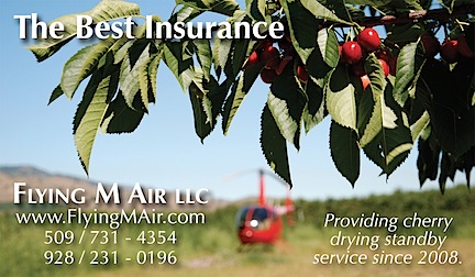
The design for my cherry drying business card comes from something one of my clients once said to me: “The best insurance is a helicopter parked in the orchard.”
In 2011, I wrote “My Epiphany about Clients and Jobs.” In that blog post, I think I finally began to understand that my business model had to concentrate on doing regular work with regular clients and to stop trying to chase down bargain-hunting tourists. Once I understood that, I settled into a routine that consisted of a busy summer season in Washington with springtime survey work and the occasional tour or air charter job that fell into my lap the rest of the year in Arizona. Now that I’m based in Washington, the survey work is out of the picture, but I’ve managed to slip some frost control work into that time slot. And I’ve got the wheels turning to maybe pick up some Washington State contract work for Fish and Game. And I still do rides and tours once in a while, although I don’t really push them anymore — not even on my website.
And that’s the way my business hums along.
Why That’s Enough
You see, I have no desire to build up a huge helicopter services business. I’m a relatively new member of the 50-something club these days and my main goal is to enjoy the rest of my life. That means working hard to earn a good living but, when I’m not working, playing hard and doing the things I want to do with my time: explore hobbies, socialize with friends, travel, etc. Why would I want the headaches of managing a big operation with multiple aircraft and employees and all the baggage that goes with them? Just to make a few extra bucks? Maybe?
There’s simply no reason to build a business beyond what I need. I don’t have kids to leave it to. And, unlike other people, I understand how to live within my means and don’t need to be a slave to possessions bought primarily to impress others. (Think Mercedes sedans, hangar queen airplanes, and poorly chosen real estate “investments.”) Best of all, I don’t have someone sponging off my hard work, forcing me to earn enough to cover the living expenses of two people.
I don’t want to spend all my free time marketing my business to a group of people who are more interested in Groupon-like deals than quality service. Why should I try to sell my services to them when I can earn a lot more per hour of my time working for people who already understand the value of my services?
I get plenty of business word of mouth and through my website. The Google street view features are completely useless to me. I don’t maintain a business office. Why put a logo on a building? Just so it shows up in a picture on Google? I don’t want to pay for that building or for the salary of a person I’d have to hire to sit in it. (And I certainly don’t want to sit in it — or anywhere else, for that matter — all day every day.) I don’t need to.
The same goes for advertising in newspapers, magazines, and other media. Why bother? I’ve tried it in the past and it didn’t work.
So when a company calls and tries to sell me something to promote my business, they’re not likely to get very far. And when they claim to know about my business and then lump me in the same bucket as giant tour operators in Las Vegas, they lose all credibility.
Whether they have “contracts with Google” or not.