
Lots of flying.
Day One: Rushing to Russians
Day Two: Page, the windy city — and more
Day Three: Lots of flying (this article)
Day Four: Night flight on the Rez, rain, rest
Day Five: Rest, a great ferry flight, and a tall ship in the desert
Day Six: One last photo flight and the long flight home
I spent a good portion of Sunday flying around Monument Valley and the Goosenecks of the San Juan River with two or three photographers on board.
Perfect Weather, Outrageous Scenery
Sunday was an incredibly beautiful day. Not a cloud in the sky, little or no wind, and clear views of everything around us. I was ready to fly at dawn and we took off soon afterward. We flew a few laps around Monument Valley, then headed north to the Goosenecks of the San Juan.
Monument Valley is cool. No doubt about it. All those towering red rocks rising from the desert floor. At this point, I think I’ve seen them from every angle in all kinds of light. I’m still awed when I get a fresh view or when the light hits a rock formation just right.
But Monument Valley is so often depicted as an icon of the southwest — remember Forest Gump running up Route 163? — that it’s become a cliche.
The Goosenecks of the San Juan, however, is something few people have seen — and it’s less than 30 miles up the road! As I’ve mentioned elsewhere, it’s best seen from the air, but there’s a perfectly good parking area at a view point that’ll give you enough of a look to remember it for a lifetime.
We flew laps around Goosenecks at 2,000 to 3,000 feet AGL. The altitude is required just to get the whole thing in the frame of a camera.
I wish I had a photo to share with you, but I’m usually pretty busy flying when I’m over it and can’t take pictures. I’m hoping that one of the photographers reads this and sends me a low-res image from the trip.
My only complaint: it was a lot colder than I’d expected up there. The two long-sleeved shirts and jeans I was wearing was not enough.
Earning My Pay
The first flight’s passengers were easy. The second flight’s were not. I was flying Mike, who had arranged the trip, and Oleg, master of 360° QuickTime VR panoramic images.
Mike speaks perfect English. Oleg speaks enough English to be understood. Neither of them have any qualms about telling me exactly where they want me to put the helicopter for their shot.
I definitely earn my pay when I fly these two around.
For Oleg to build his panoramas, he needs me to get the helicopter into a hover and then make two 360° pedal turns, one right after the other. For those of you who aren’t familiar with the idea, a pedal turn is a rotation on the helicopter’s vertical axis (it’s mast). It’s a pretty tricky maneuver because it requires the pilot to perform a few difficult tasks at once:
- Get the helicopter into an out-of-ground-effect hover. That means coming to a dead stop hundreds (or thousands) of feet in the air, where ground reference points aren’t exactly easy to track.
- Get the right power setting for the helicopter. Too much power and it could climb (unlikely at our weight and elevation); too little power and it could descend (very likely at our weight and elevation).
- Recognize and recover from settling with power. That’s a condition when a helicopter settles into its own downwash. Unless you’re flying very light or very low, it’s going to happen at one point or another. The trick is to catch it before it gets out of control and you lose a lot of altitude in recovery. (Settling with power is one of the reasons newly minted helicopter pilots should not do aerial photography gigs — sometimes they just can’t recover before they run out of altitude.)
- Use the pedals to turn the helicopter smoothly on its axis for 720 degrees. In a no-wind situation, this isn’t too tough. But if it’s windy, you’re fighting the wind any time you’re not pointing into it. If the wind is strong enough, LTE (loss of tail rotor effectiveness) can set in, making it even tougher and sometimes — just sometimes — causing a case of “the wiggles” that greatly resembles a loss of control.
Usually, Oleg only asks me to do one of these maneuvers per flight. But this time, he asked for five or six. And in the past, he’s only wanted one pedal turn. Now he wants two. This year, he has a special camera mount on a pole that he can stick out the helicopter door for the shots. He doesn’t want the skids in the photos.
What I discovered is that if I glanced down at the directional gyro while performing the maneuver, the quick spin of the dial would make me feel sick.
And this might sound silly, but I have a touch of acrophobia. You know. Fear of heights. I sometimes get that weird feeling in my gut when I climb a ladder to preflight the rotor hub. Or when I look down from a high place. Or when I pivot a helicopter 2,000 feet above a snaking, curving canyon. Especially with my door off.
I kept my door on and remembered what I was being paid for.
At Cal Black
We went for a fuel run halfway through that second flight. That took us to Cal Black Airport, 10 miles from Lake Powell’s Hall’s Crossing Marina.
Cal Black is a very nice little off-the-grid airport. Paved and lighted runway, rotating beacon, tie-down parking, and both 100LL and JetA fuel. It’s managed by a man named Maury who lives at the airport. When you call in, he gives you an airport advisory. If you say you’re coming in for fuel, he’s waiting at the pump when you arrive. Even if you arrive at 6:30 AM. Or in the rain.
That’s service.
I asked Maury to fill up the tanks and he obliged. Mike and Oleg wandered off into the red rocks so Mike could have a cigarette. Maury and I talked about running an FBO in such a remote place. I warned him that I’d be coming early the next morning and asked if I should call him.
“I keep a radio next to the bed, turned down low,” he said. “I’ll hear you coming if you call in.”
We flew back to Gouldings by way of Goosenecks. I performed my pivot maneuver for Oleg. I was glad that the wind wasn’t howling at 2,000 feet AGL. I was tired. I’d been flying almost nonstop since 7 AM and it was getting close to 11.
A Break
After putting the doors back on the helicopter, I accepted a ride from my passengers up to the lodge. We got a table for six or eight, although I don’t think we had more than four people at it at any one time. I had a hamburger with chili on top of a big piece of Navajo Fry Bread. I really like fry bread. My passengers picked up the tab.
I relaxed in my room for a while. Then went out to the middle of the runway to try my hand at a panoramic image. I took 18 shots with my 50 mm lens on. I’d been planning to stitch them together manually with Photoshop, but Photoshop said my scratch disk was full. While looking for files to delete and make room, I stumbled across Photostitch software from Canon that I must have installed when I got my first Canon camera. After playing around with it, I got it to create this little QuickTime VQ panorama. (Go easy on me, folks; this is the very first one of these I’ve ever created.)
[qt:https://aneclecticmind.com/wp-content/movies/Gouldings2.mov 400 300]
This is QuickTime VR, so you’ll need QuickTime to view it. Click and drag in the window to pan from side to side. If you look all the way to the left, you’ll see Monument Valley and the hangar I’m staying in. If you pan to the right, you’ll see my helicopter on the ramp.
More Flying
I needed to make another fuel run before the next flight and had until 4 PM to get it done. Mike said he might send someone to fly with me. “If he’s not there by 3:30,” he said, “he’s not coming.”
So, at 3:35, I went out and started the helicopter. I had all doors on (for warmth) and my iPod (for entertainment). I’d just gotten the RPM up to warm-up speed (68%) when one of Mike’s rentals came screaming into the ramp area. The door opened and Gleb popped out. I didn’t want to shut down and he knew all the safety rules, so I waved him over to my door.
“Do you want the door off?” I asked, knowing what the answer would be.
So even though the controls were locked down, I had him stand at my door to watch them while I went around to the other side and removed the back door. (The front door was locked and I needed a key to unlock it, which would require shutting down.) I handed the door off to the guy who’d driven him there, then sent him around to his seat and settled myself in mine. As the truck drove away with my door, I never really thought about what might happen to it. (I’d been storing all the doors in my room at the hangar for each flight.)
We took off for Cal Black. With a door off, my speed was limited to 100 knots, but I think I could have gotten 110 out of it, even at that altitude with two people on board. Maury was waiting for us and took care of us quickly. Gleb asked him questions about courtesy cars — there is none at Cal Black — and Maury explained the shuttle to the marina that’s available between 8:30 and 4:30 each day.
On the way back, we hit Goosenecks and then Monument Valley. Actually, Goosenecks is not on the way back. Imagine a triangle with Cal Black AIrport, Goosenecks, and Monument Valley at each point. The legs between Cal Black and Monument Valley and Cal Black and Goosenecks are about the same: 20 or so minutes of flight time. The one between Goosenecks and Monument Valley is quite short: 10 minutes of flight time. Along the way, we saw wild horses and some interesting rock formations. On the way back from Monument Valley to Gouldings, we saw a herd of sheep grazing on the high school football field.
One more flight that the afternoon. Not too tough. Goosenecks first, then Monument Valley. If we would have gotten back 30 minutes before sunset, I would have made my fuel run then for the next day. But we landed 15 minutes before sunset. And I wasn’t the least bit interested in flying over dark desert back to an unlighted field. Fueling would have to be done before dawn the next day.
Winding Down
There was no wind, so I skipped the tie downs. I was going out early in the morning and didn’t want to deal with them unless I had to.
I walked to the grocery store about 1/3 mile away and bought some orange juice and fruit and green tea. I walked back in the growing darkness and settled myself in for a night of relaxation That included two attempts to get time exposures of the perfect night sky. Failed miserably.
[composed in a hangar/hotel room while on a flying gig with ecto]
 Ah, but first you had to pass the entrance exam. I mean that quite literally. You had to step down into the canyon, which appeared as a narrow slot (see photo). I’m not huge but I admit that I had to twist my body a bit to fit into the opening of the canyon. A really fat person never would have made it, which explains why there really weren’t any really fat people in there.
 There was fine sand under foot and blowing sand drifting down into the canyon from above. Soon, there was sand in my hair and clothes and camera lens. It was a fine red sand that gathered in small dunes and drifts outside the canyon. Inside, it fell like rain from the sky. (One of the first things I did when I got to my hotel room that night was to take a hot shower and get all that sand off me.)
 I took lots of photos. For some reason, I thought the light would be better in Lower Antelope Canyon than the Upper Antelope Canyon, so I’d left my tripod in the car. Very dumb. I really could have used it in there. So I had to play with the camera, using Program mode for some shots and setting other shots to a minimum shutter speed of 1/30th of a second. About 1/2 of the shots are usable and about 1/2 of those aren’t bad at all.
 I took off right over the ramp and hangars. I had plenty of lift with that headwind and light weight. Things were tricky for the first minute or two, but once I had a good climb and forward airspeed going, I was able to bank gently to the left. The wind pushed me sideways over town. I passed the Navajo Power Plant and headed east.
 We started with a trip around Horseshoe Bend, which is south of the Glen Canyon Dam. It’s a neat spot where the river bends in the shape of a horseshoe. The canyon is deep there and the river is calm, green, and cold, having come from depths of Lake Powell. Lots of people like to see Horseshoe Bend, but I think the Goosenecks of the San Juan near Mexican Hat Utah are far more impressive. And the twists and turns in Lake Powell where the San Juan meets the Colorado are simply magnificent — as this photo, which I’ve used over and over again on this site (with apologies to regular readers) attests.
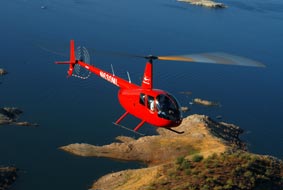 Air-to-Air session. Jon rode with my friend Dave in his Hughes 500c, doors off to get glare-free images of Zero-Mike-Lima. I blogged about that shoot in “
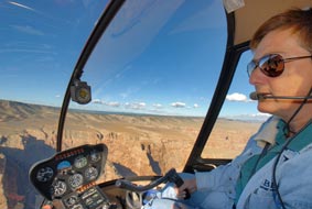 Half-day flight around northern Arizona. Jon’s goal was to photograph some of the places I typically fly over, as well as to get shots of me at the controls with these places in the background. We started in Wickenburg and flew north over Prescott, Mingus Mountain, Jerome, Sycamore Canyon, Howard Mesa, Little Colorado River Gorge, Roden Crater, Grand Falls of the Little Colorado River, Winslow and La Posada, Meteor Crater, and Sedona. Jon got some great shots.
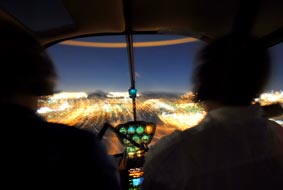 Sunset/Moonlight Dinner Tour. This is one of the tours I offer in the Phoenix area, a flight to a Falcon Field (in Mesa, where we went) or Scottsdale Airport at sunset for dinner followed by a return trip in the moonlight. Jon took some interesting nighttime photos.
 Landing at Norquist home. The Norquists have a unique hilltop home on the northeast side of Wickenburg. I flew for them about a year ago when their Realtor hosted an open house and wanted visiting Realtors to see the town from the air. They graciously allowed us to land there for a photo shoot with the house in the background. We enjoyed some wine — well, Jon and Mike did, anyway; I still had to fly — and great conversation with some really nice people. (BTW, the house is for sale.)