Some photos from a trip back to New Jersey and New York for the Thanksgiving Holidays.
I didn’t want to go, but Mike talked me into it. Then we made flight reservations before I could change my mind. It would be a short trip. I’d fly out on Wednesday and return on Saturday. Only three nights, and those would be made comfortable with a room at the Glenpointe Marriott in Teaneck, NJ. Dinner with my family at my brother’s house in New Jersey on Thursday, dinner with Mike’s family at a restaurant in Queens on Friday, Dim Sum with family and friends in Ft. Lee, NJ on Saturday morning.
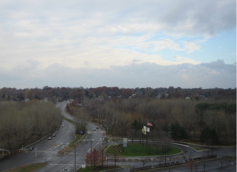
The New York/New Jersey metro area where I grew up and lived most of my life is very different from Wickenburg, AZ, where I live now. So different that I decided to take some photos to try to document some of the differences. I could have done better, but this is what I’ve got to share. This is the view from our hotel room in Teaneck, NJ, on Thursday morning. It had snowed and rained during the night and it was bitter cold that day.
This looks out to the southwest. As you can see, there are lots of tall trees, but they’re pretty much bare in late November. The overall effect is gray. A gray day with gray skies, gray trees, and gray pavement. I hated the gray of the New York metro area in the winter months. But it was the cold that finally chased me out of the area.

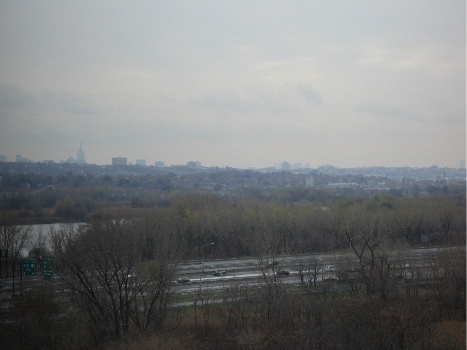
Here’s another look from our hotel room window. This view looks toward the southeast. The highway in the foreground is I-95, which stretches from Maine to Florida. The body of water is some marshland that might just be close enough to the Meadowlands to be considered part of it. The gray buildings poking into the gray sky are the skyscrapers of New York City off in the distance. The pointy one on the left is the Empire State Building, which is now the tallest building in New York again. It formerly held that title from 1934 to 1977, when the World Trade Center was completed. With the WTC gone, this depression-era building is once again the tallest in the city.

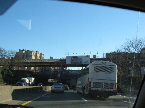
On Friday, we drove to Queens. Here’s a snapshot taken on the Cross Bronx Expressway, which goes from the George Washington Bridge (on the Hudson River), across the top of Manhattan and the middle of the Bronx, to two of the bridges to Long Island: the Whitestone and the Throgs Neck. When I was growing up, this area of the Bronx was filled with burned-out building shells, and we’d often see broken-down or abandoned cars being stripped on the side of the road as we drove through. But the buildings have they’ve since been renovated and people live there once again. Don’t get the idea that this is an up-and-coming area of New York, though. It’s still a poor, crime-ridden area. Ever read Bright Lights, Big City?

I forgot to take photos the day before, on the way to my brother’s house. We took the New Jersey Turnpike (I-95 down) and there are lots of weird scenic things along that, like the big gas tanks that appeared in a scene of Stephen King’s The Stand and Newark Liberty International Airport. Next time.
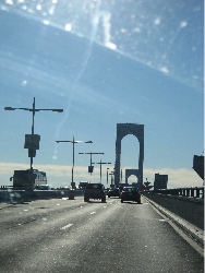
Here’s a pretty poor photo of the roadway on the Whitestone Bridge.

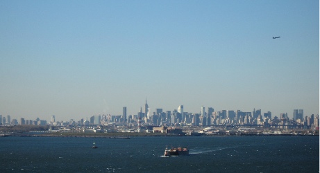
There are three bridges that’ll get you from the Bronx to Queens and Long Island and they’re all pretty similar in appearance: single-span suspension bridges. The Triboro Bridge has some nice art deco touches that make it my favorite of the three bridges, but that one’s much closer to Manhattan, which was out of our way. The Throgs Neck bridge has great views of the Long Island Sound which, in the summer, is full of sailboats and very picturesque. Of course, the Whitestone Bridge does offer the best long-distance views of Manhattan. I took a bunch of photos and this one was the best. It really gives you the flavor of new York from a distance. The tugboat with barge in the foreground, the plane departing La Guardia Airport (out of this shot on the left), and the huge cluster of buildings in midtown Manhattan. You can clearly see the Empire State Building almost dead center and CitiCorp Center (look for the slanted roof to the right). Astoria, Queens is in the foreground, on the other side of the water. And you can just about see the heavy black bridge of the train trestle that parallels the Triboro Bridge. If the World Trade Center were still standing, its towers would appear to the far left in this photo.

If you’ve never been to New York and you have the opportunity to visit, don’t pass it up. New York is like no other place on earth. As I was telling a Phoenix cab driver just the other day, it’s one of the few U.S. cities that blend old and new in a way that leaves you breathless. Go downtown, to the Wall Street area, and see exactly what they mean by the “Canyons of Wall Street.” The streets are so narrow and the buildings are so tall that light rarely gets down to the street. Although midtown has more tall buildings, the streets are a bit wider. You won’t believe the crowds walking the streets during a weekday lunch hour, the sea of yellow cabs, the bicycle messengers, the street vendors. This time of year, they’re roasting chestnuts near Rockefeller Center and steam is rising from manhole covers and vents on the street.
I do love New York, but I don’t have enough money to live there the way I want to. And New York is one of the grayest places I know.
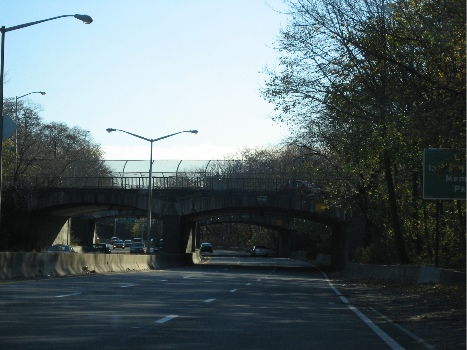
We didn’t get into the city during this trip. Next time I go back, I’ll take some photos. But you might have to wait a few years. Once in Queens, we hopped on the Cross Island Parkway to go to Mike’s Mom’s apartment. I took this shot out the front window of the car. It’s an interesting example of one of Robert Moses’s parkways. He built them all over Long Island — Queens is on the eastern end of Long Island — and this was probably one of his first. One of the trademarks of his roadways was his stone overpasses. They all look pretty much the same, but they’re really nicely executed. When you look at this photo, it’s hard to imagine that tens of thousands of people live within a mile of where it was taken.

This stretch of roadway is sunken in and surrounded by trees. Mike and I had our first apartment together about 5 miles further down this road, in Bayside. We had a wonderful view of Littleneck Bay (you’ve heard, perhaps, of Littleneck clams?), but had to listen to a never-ending stream of cars going by far beneath our terrace.
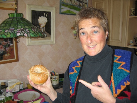
At Mike’s mom’s place, we had bagels for breakfast. This is a photo of me holding a real New York bagel. Notice that it is large and plump. The outside is crusty and the inside is moist and almost doughy. It doesn’t have blueberries or cranberries or any other type of berry in it. This one has sesame seeds (my personal favorite), but they also come plain, egg, poppy seed, salt, pumpernickel, onion, cinnamon raisin, or everything. Everything means seeds, onion, and salt and is a real assault to the taste buds. A common way for a New Yorker to eat a bagel is to slice it open and toast it, then cover each half with cream cheese and slices of lox (smoked salmon). Some people add red onions, capers, and/or tomatoes. (I don’t like tomatoes on my bagels.) A quick spread of cream cheese is referred to as a “schmear” in New York; I prefer a more generous helping. You can’t get a good bagel anywhere outside of the New York metro area, although you can get decent ones here and there. Einstein Brothers makes a decent bagel. Bagels do not come in the grocery freezer section; anything you find there that is labeled a bagel is a mere imitation.

The next time you go to New York, have a bagel as described above. It’s part of the New York experience and should be required for all serious visitors. And, while you’re at it, take a ride down to the Lower East Side and have a corned beef, pastrami, and tongue on rye sandwich at Katz’s Deli. Get that with mustard. Do not ask for it with mayonnaise; you will be forcibly removed from the premises and publicly laughed at out on the street. A Dr. Brown’s Creme soda is a nice accompaniment — and don’t forget the kosher pickle. Leave the Carnegie Deli for the tourists. What you’ll learn — among other things — is how to properly make a sandwich. There should be more meat than bread. That’s something they just don’t get outside the New York metro area.
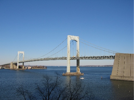
But I digress, again. This is a photo of the Throgs Neck Bridge, taken from Mike’s mom’s patio. She’s on the 7th floor and has a nice view out this way. Beyond the bridge is the Long Island Sound. Imagine it with lots of sailboats and you’re imagining the view on a summer Sunday afternoon. Put some green leaves in the tree in the foreground to complete the picture.

As you can see, it isn’t always grey in New York in the winter. Friday was a very nice day, although it was still bitter cold, with temperatures in the 30s and enough wind to make it feel a lot colder. Of course, it did get gray again on the next day.
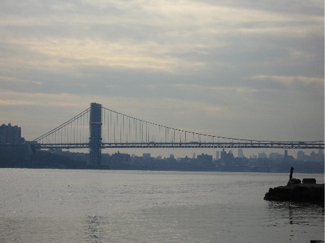
Here’s a look at the George Washington Bridge from the foot of the Palisades. The Palisades, in case you’re wondering, are a line of cliffs along the Hudson River in New Jersey. This photo was taken from a boat basin/park area almost directly across the river from the northernmost end of Manhattan. The view is to the southeast.

The GW Bridge has two decks — upper and lower — and is a major route between New Jersey and eastern New York. It’s actually the first bridge you get to if you sail up the river from New York Harbor. The next bridge is the Tappan Zee, which is at least 20 miles further upriver. To cross the river closer to downtown Manhattan, you can use one of two tunnels: the Lincoln (midtown at around 30th Street) and the Holland (downtown at around Houston).
When I was growing up in New Jersey, my family had a small boat that we used to take out in the river. I’ve been around Manhattan by boat more times than I can count. It’s a neat trip that you can do on the Circle Line tour boats. We also took a few perilous trips into New York Harbor and around the Statue of Liberty. I say perilous because our boat was really small and the water can get rough out in the harbor. I also remember going past Ellis Island long before it was fixed up and opened to the public. I’ve never been on the island, though.
Anyway, all those boat trips started at the base of the George Washington Bridge, on the New Jersey side. I can still remember the smell of the water at low tide, and the look of all those exposed barnacles. And the way the boat floated up and down as it was loosely tied at the boarding area. We didn’t swim in the river back in those days — it was too polluted south of the Tappan Zee — but we did fish in it, although we never ate any of the fish we caught.
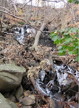
Here’s a shot of one of the “waterfalls” coming down the Palisades to the Hudson River. It’s really probably just runoff from a storm drain, but when we were kids, it was a waterfall and it was one of the most beautiful things we’d ever seen. My family often drove along the river’s shore road on Sunday outings. That’s back in the days when taking a drive in the family car was a cheap and fun day out. There were no malls, no computer games, no cell phones. We’d get in the car and go for a drive and drink up everything we saw out the window. If it was autumn, we’d go to a place called Tices Farms, which had apples and doughnuts (note the spelling) and cider and pumpkins for sale. When I got out of the car to take this photo, the smell of wet leaves brought me back to a time when we would rake them into huge piles and take turns jumping in them. Leave stems would stick in our sweaters and hair and we’d be breathless in the cool autumn sun. I don’t know if you can see it clearly, but there’s ice in the water in this photo. We’re talking cold enough to make a waterfall freeze. Cold.

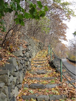
The Palisades area of Bergen County in New Jersey is one of its more historic areas. Originally settled by the Dutch in the 1600s, it was a hotbed of activity during the Revolutionary War. Posted alongside roads all over the area are “Washington’s Retreat Route” signs. Yes. This is the area George Washington retreated from when we weren’t doing very well in the first war with the Brits. Why we need that on signs is beyond me. But the area is also full of walking trails that were probably built during the depression. In more than a few places, you can find stairways and paths that climb the Palisades. This is one example, that follows the road for a short distance before cutting right up the cliff. We did a lot of hiking in the area when we lived there. The views from the top of the Palisades are magnificent.

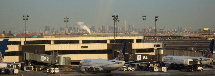
I took the shot that appears below from the AirTrain that travels around Newark Airport. That’s New York in the background.

This photo reminds me of a visit by one of my editors when we still lived in New Jersey. I picked him up at the airport and was driving north along the New Jersey turnpike toward our house. He looked off to the right as we climbed a bit of highway that passed over the marshes at the Meadowlands and said, “What city is that?” He was looking at New York. That’s when I realized that the skyline I’d grown up with wasn’t nearly as familiar to everyone else.
Am I homesick? Maybe a bit. Would I go back to live there again? Nope.
Been there, done that.

 Mike already had Jack out of the helicopter as I was cooling the engine down when Robin came in for a landing. Although I thought there was enough space beside me, Robin didn’t think the spot looked level enough. He wound up parking a few dozen yards east, on the same side of the strip.
 After lunch, we took a short hike down to the river. It was rushing pretty good and the sound of the flowing water was great. There’s plenty of space down there to camp and we hope to come back in the spring, when it’s warmer at night, to camp out. I’m hoping Jason and his fiance, Becky, can join us. Jason still flies in with the Citabria that’s older than he is. But somehow, I don’t think we’ll camp by the river. I think we’ll be up by the runway, by that picnic table.
 After scouting around down by the river, we followed an old road up to a shack built high above the river. There were some cattle pens there and the place was pretty beat up. Supports for the porch roof had collapsed and the metal roof panels hung down against the side of the building. The concrete pad the place was built on had 1964 scratched into the cement. Inside, the building showed signs of recent use, including a new set of steps leading up to one of the bunks and a sleeping bag in decent condition.
 Jack spent most of the ride back lounging in the back of the helicopter, stretched out on both seats. He was tired after all his running around. Mike shot this photo of him looking out the window as we neared the airport. That’s Wickenburg down below — one of the motels and Denny’s, with the newly built apartments and condos below them. It almost looks as if Jack was enjoying the view. Almost.
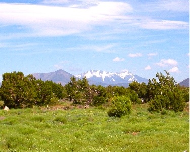 Howard Mesa was beautiful. Or maybe I should say that it was more beautiful than usual. The grass was knee-high and green and the seed tops swayed with the wind. The San Francisco Peaks were still snow-covered, off in the distance. Best of all, we seemed to have the whole place to ourselves — as usual.
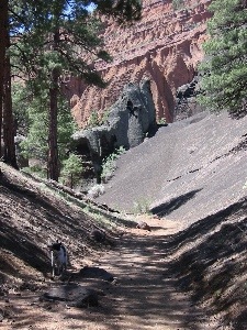 The trail, which was wide enough for hikers, bikers (the pedal kind, that is), or horseback riders, was smooth and covered with crushed red cinders. In places, it was heavily eroded, but not enough to make walking a problem. That was a good thing, because I hadn’t brought hiking shoes. I was wearing my red Keds and that’s probably the only kind of surface I could have walked 3 miles on. The trail climbed gently most of the way. It wound through the trees, then dropped into a smooth-bottomed wash and climbed toward the mountain in that. Soon, we were in a canyon with slopes of dark grey volcanic gravel on either side of us. It was fine stuff, like the red cinders we walked on. There were a few interesting formations right at the mountain’s entrance. Beyond them, we could see the red hoodoos inside the mountain.
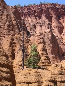 It appears to me that Red Mountain had once been a plain old mountain. Volcanic activity on one side had caused black lava to spew out of the ground. This undermined the mountain, causing a slide that took out about 1/3 of the mountain side. The result was the amphitheater the booklet told us about. Of course, this is all conjecture based on what it looked like. There was no interpretive sign in the parking area or elsewhere and no ranger to explain what we were seeing. I could have it completely wrong.
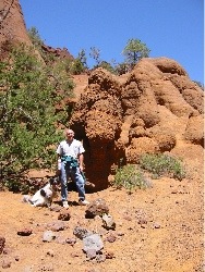 There are two ways into the mountain, both of which were described in the book. At the head of the wash we’d been following, someone had built a neat rock dam. A ladder climbed the six or eight feet up to the top of the dam where silt had backed up, raising the ground to the top of the dam. That’s how we went. Jack took the ladder like a champ. The other way was to climb up over a gray cinders covered slope. That’s probably the only way you could get in with a horse. (I know my horse doesn’t climb ladders.) Our way was easier. Inside the mountain’s amphitheater was exactly as the booklet had described. Lots of rock formations made of red sandstone carved by wind and water, with a bunch of dark gray formations just to make things interesting. We walked up to the head of the canyon, passing a family having lunch with their dogs. One dog, a Corgi, came yapping out after us, followed by a dog that looked like a mix of every dog breed in the world. Jack had some sniffing with them, then followed us.
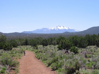 I took this photo of Jack as we neared the parking area. It’s the new desktop picture on my laptop. That’s the San Francisco Peaks in the background; you can see Jack running on the trail, tongue hanging out, on the left.