Cheaper Charts from NACO

I find a less expensive source for aeronautical charts.

For the past few years, I’ve been using iPilot.com as a source for my aeronautical charts. I subscribe to the charts I want, providing a credit card number up front. When the new chart is available, it’s automatically shipped to me and my card is charged for the amount due. The service is very good and very reliable. I always get the new charts before the old charts expire. The prices are slightly discounted and, for regular charts, shipping is free.

Shipping is not free, however, for the Airport/Facilities Directory (A/FD) — that green book with information about airports. Although I seldom refer to this book, I’m required by the FAA to have a current one covering my area of flight on board my aircraft for every Part 135 flight — which is pretty much every flight I do. The books cost $4.45 each. Shipping, however, is another $4.80. That brings the total to $9.35.

Every 56 days.

It’s a tough nut to swallow. After all, it’s a book I rarely refer to which rarely changes. Yet I’m required to buy it every 56 days. It’s an operating cost — one of the smaller costs that make owning and operating a helicopter charter business so costly. And yes, that might not seem like much, but when you have 20-40 of these stupid little expenses, they really add up.

FAA LogoI’ve ordered charts from NACO — that’s the National Aeronautical Charting Office of the Federal Aviation Administration (FAA) in the past. Although they sell charts at list price, they don’t charge for shipping. They also don’t charge for shipping non-chart items like the A/FD or similarly bulky Terminal Procedures Publications (TPPs).

But, as I discovered today, they do discount items when you buy subscriptions. A subscription for an A/FD is 7 editions — basically a full year. A subscription for a Sectional chart is 4 editions — basically two full years.

So, for example, I can subscribe to 7 editions of the Southwest A/FD for a total of $27.02. That’s $3.86 each. Shipping is included. So I save about $5.49 per 56-day cycle. Or $38.43/year.

There is a downside to this. Two of them, really:

  • You must pay for an entire subscription up front. There are no refunds. So rather than pay each time an item is shipped, it’s all paid for in advance.
  • You must renew the subscription manually when it expires. NACO will send you a reminder via e-mail 30 days in advance so you don’t forget, but it is slightly less convenient.

Today I switched my A/FD subscription from iPilot.com to NACO’s online ordering service. I’m keeping my charts with iPilot.com, at least for now. I’ll wait and see how well NACO handles the subscription before I make any more changes. I wouldn’t be saving that much money on a chart subscription and I rather like the convenience of iPilot’s system.

One more thing I should mention…you can download pages from the A/FD or TPP publications for free on an as-needed basis. Although this would not satisfy my requirements for the A/FD, it’s certainly handy for folks needing airport diagrams and instrument approaches. Most of us don’t need them all, right?

If you haven’t checked out the NACO site, I recommend doing so. There’s a lot of information there. Sure, it’s not a pretty site, but you know it’s accurate because it is the source.

The Wayside Inn is Open

Stop in for a hamburger in the middle of nowhere.

I’ve written about the Wayside Inn before in this blog. In my post, creatively titled “The Wayside Inn,” I go into a lot of detail about the place and a visit there by helicopter back in 2003. You might find that piece interesting reading if you enjoy long, rambling stories about my helicopter travels. (Some people do.)

The short version is that the Wayside Inn is a small trailer park with a restaurant in the desert about 5 miles south of Alamo Lake. It’s accessible from Wickenburg and the rest of the world by two routes: the 40+ mile long dirt road that starts near Date Creek off Highway 93 or the combination of paved and dirt roads starting in Wendon (on Highway 60) and stretching to Alamo Lake. There’s another road from the north and I have no idea where it starts, but I do know that when the lake is full, the road is under water.

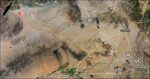
You can get an idea of its remoteness by this Google satellite image, which also includes Wickenburg. The red X is the Wayside:

The Wayside Inn on a Satellite Image

The Wayside Inn has been a destination for pilots for quite a while. It has a landing strip, but the strip has been left to get overgrown with bushes and weeds and is not maintained. So instead, pilots just land on the dirt road in front of the place. I’ll admit that there aren’t many pilots who do this. It’s mostly the folks who fly taildraggers and aren’t afraid of landing on something that isn’t a real runway. And helicopter pilots, of course.

About a year ago, the Wayside Inn burned down. I didn’t know the details, but had noticed that the building was missing when I flew from Wickenburg to Las Vegas last November. The building was simply gone.

But a few weeks ago, I saw a flyer up in Ed’s hangar. Ed is the local aircraft mechanic and he does some of my engine work, including oil changes. The flyer announced that the Wayside had reopened. I put it back on my mental list of places to go for a quick bite to eat in the middle of nowhere.

On Sunday, October 19, I had an opportunity to check the place out. I was taking a video guy and a journalist along on my Southwest Circle Helicopter Adventure. Another video guy would be meeting us in Sedona. We had a few hours to kill before we were due to arrive at Sedona Airport. I figured that a stop a the Wayside would kill some time without taking us too far from our course.

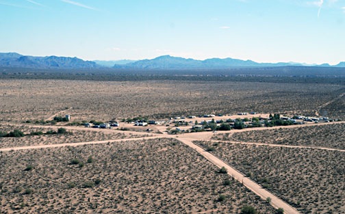
So I flew us out there. The journalist took this photo as I made my approach to landing. I set down on the big triangular area at the crossroads, across the main road from the trailer park.

Landing at the Wayside Inn

The old building had been replaced with a double-wide manufactured building. Inside, the layout was much the same as the old building had been: bar, tables, pool tables, and a limited amount of groceries and fishing supplies for sale. All of the Polaroids of fishermen and their fish were gone. The drop ceiling panels were decorated with good-luck dollar bills signed by patrons. Before we left, we added one to the collection.

The video guy interviewed the owner of the place. Turns out, he’d bought the place right before the fire had burned it to the ground. After the interview, he made us breakfast. When it was time to leave, he rode his ATV out to the helicopter with us while his dog rode on the back and asked my journalist friend why she hadn’t eaten her bacon. (She’s a recovering vegetarian.)

We’d stopped in for just about an hour. The meal was good, the price was reasonable. The atmosphere was pure Arizona “remote.”

If you’re ever out by Alamo Lake and want to stop for a bite to eat, I hope you’ll look for the Wayside Inn. If you stop in, tell them that Maria in the red helicopter sent you.

Helicopter Shadow Takeoff Video, Take 2

Another video from my helicopter.

A while back, I published a short video of a takeoff in my helicopter with the sun behind us. The shadow on the ground looked pretty cool. You can find it here.

Yesterday, while experimenting with a borrowed wide-angle POV.1 video camera, I shot the following video. I didn’t realize that the shadow would be a main character. My goal was to fly low over the runway to simulate an airplane takeoff. Because I’m not an airplane pilot, it wasn’t very realistic. But it is kind of cool, and the shadow puts in quite an appearance all the way through.

The sound is collected through the POV.1’s built-in speaker, so it’s mostly helicopter noise. I start on the taxiway intersection, hover out to the runway at midfield, and do my thing.

The video is only a minute and a half long. Enjoy.

On the Road Again

Traveling again.

If you’re wondering why you haven’t heard from me here in a while, it’s because I’ve been traveling. I’m doing one of my Southwest Circle Helicopter Adventures in northern Arizona, accompanied by a video crew and staff writer for a respected travel magazine.

The goal of this trip is to gather about 90% of the video needed to create three individual broadcast-length videos, each of which will be made available on DVD. It’s a huge project and, so far, we have at least 20 hours of raw video footage to wade through.

I’m flying with a door off and a video guy on board taking glare-free video images of what we fly over. He also has at least two POV.1 cameras mounted inside the helicopter at all times. The other video on the ground is “chasing” us — actually, he’s getting a big head start each day to drive to the airport where we’ll land before we arrive — and taking video of us landing. Then there are cameras whirring all over the place on the ground.

Wild HorsesThe writer is sitting up front beside me, taking notes and using my Nikon D80 to shoot images of what she sees. Although a good portion of the shots have some unfortunate glare — not much you can do about that when shooting through Plexiglas — many of them are really good. Like this shot she took of a herd of wild horses we overflew on the Navajo Reservation two days ago.

It’s been a busy week so far. Although I’m trying to demonstrate to the writer what my Southwest Circle Helicopter Adventure is all about, I’m also working with the video crew to make sure we capture all of the footage we need for our three videos. I’m hoping she understands that my usual clients won’t be rushing around like nuts all day.

Antelpe CanyonI’m treating myself to a few of the activities my excursion guests get to enjoy. For example, on Tuesday, I joined the crew for a boat ride on Lake Powell that visited the “business side” of the Glen Canyon Dam before squeezing about a mile up Antelope Canyon (see photo) and gliding up Navajo Canyon for a look at the “tapestry” of desert varnish on some cliff walls. I skipped the Sedona Jeep tour and Monument Valley tour to work with one of the video guys or just rest up. Normally, while my guest are touring, I’m scrambling to get the luggage into their hotel room and confirming reservations for the next day. You might imagine how tired I am after 6 days of playing pilot and baggage handler.

At this moment, however, I’m sitting at the dining table of a double-wide mobile home near Goulding’s Lodge in Monument Valley. (Long story; believe it or not, the only lodging we cold get here in MV was in a pair of mobile homes that are part of the lodge.) I have the front drapes drawn aside so I can watch the eastern sky brighten for what promises to be a classic silhouetted butte sunrise. I always enjoy my dawns here at MV. Seeing the famous buttes outside my window is always surreal.

Today, we were scheduled to fly down to Winslow for lunch, then tour Meteor Crater and the Grand Falls of the Little Colorado River. Normally, the Southwest Circle Helicopter Adventure takes this route on the way to its last overnight stop at Flagstaff. But today we’ll probably go straight back to Page. I have four aerial photo shoots at Page starting on Friday morning; the money I make doing them will pay for this video excursion. We’ll do more video between those flights. Then we’ll hit the Crater, Falls, and Flagstaff on our way back to the Phoenix area on Sunday.

It’s a big trip and a bunch of huge projects. Just the kind of thing to keep me busy between flights for the winter season. But if all works well and as planned, I might be flying this route weekly in the coming spring and fall — with real paying passengers to take care of along the way.

Kids Ask a Lot of Questions

A quick note from a recent flight.

I recently flew a dad and his two kids on a 50-minute flight in the Wickenburg area. The kids were aged maybe 8 (the boy) and 10 (the girl). These are estimates. I didn’t ask and since I’m not a parent myself, I could be way off.

My helicopter has a voice-activated intercom system. That means that anything anyone says into their headset microphone can be heard by anyone else in the aircraft wearing a headset. (And yes, I do have an isolation switch I can use to “turn off” my passengers, but I rarely use it.) I narrated the flight, as I usually do, and pointed out interesting things.

Now I’ve flown kids before, but these kids were different. They asked a lot of questions. A lot. In fact, they pretty much never stopped asking questions.

I have no problem with this. It’s great to see kids who are interested in what’s going on around them. And it sure beats the kid who almost fell asleep on one of my Grand Canyon flights years ago.

Since I don’t have kids, however, it was a bit startling to me. It made me realize the limits of a young kid’s knowledge. For example, they repeatedly asked me to define words I’d used — irrigation and skeleton crew come to mind. They asked a lot of “why” and “how” questions. It was a real eye-opening experience for me. It was also a pleasure to be in the position where I could share some of my knowledge with them.

But the part I liked most was defining those terms I’d used without a second thought, bringing my vocabulary down to a level they’d understand and perhaps teaching them a few new words and concepts.