Bryce Canyon to Salt Lake City, UT.
– Day 1: Wickenburg to Page, AZ
– Day 2: Page, AZ to Bryce Canyon, UT
– Day 3 AM: Bryce Canyon to Salt Lake City, UT
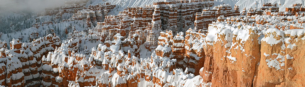
I woke to a beautiful day at Bryce Canyon. Of course, I didn’t know it at the time. It was still dark. The weather forecast had called for overcast, so when I looked out into the predawn sky and saw only grayness, I assumed the area was clouded over. But as the day brightened, I realized that it had been just a thin cloud that hid the stars from view. It cleared out to reveal a blue sky.
I grabbed my camera and walked from my cabin to the rim trail. A bunch of folks were there in bunches at viewpoints. Shivering against the cold, I joined a pair of Canadians with the same idea I had: shooting the rock formations in the early morning light. I spent the next hour walking the rim, photographing the view. I’ll share some of those photos in another blog post.
Knowing from the previous day’s experience that I wasn’t likely to get a good meal at the lodge’s restaurant, I went back to my cabin, packed up, and checked out. A while later, I was leaving the park and pulling into the parking lot at Ruby’s Inn.
Ruby’s is a tourist trap. I can’t say it any other way. Every little town outside a National Park is full of them. Ruby’s, like so many of the good ones, has it down to a science. Buffet breakfast designed to satisfy the Americans and awe the Europeans and Asians. Clean comfortable seating. Huge gift shop. WiFi. I settled down in a booth, got tired of waiting for a server, and just served myself from the buffet. The price was far above average so, in true American fashion, I ate a lot more than I should have to get my money’s worth. Sometimes, I’m a real idiot.
After topping off the rental car’s fuel tank, I drove to the airport. By that time, the morning was truly beautiful, with clear skies and light winds. To the north, I could see a hint of some clouds. The weather in Salt Lake City — which I’d checked while at Ruby’s on my iPad — was overcast with showers. I wondered how long I’d be flying before I reached the southern edge of the weather.
I settled my bill with the FBO, left them the car keys, and went out to the helicopter. After a preflight that included checking for ice on the blades (some frost, but it was melting fast in the sun), I climbed aboard and started up. It took a good ten minutes to warm the engine. Then I was lifting off, heading northwest toward Panguitch.
I’d planned this leg of the flight days before and had repeatedly wondered whether It was a good route. Sometimes I do that. I decide on one thing and repeatedly have second thoughts about my decision. Is that a woman thing? I don’t know. But this time, I stuck with it.

An example of one of the red rock canyons northwest of Bryce, as seen from the air.
The landscape was immediately amazing. I was coming off the plateau on which Bryce “Canyon” sits. Bryce is not really a canyon at all. It’s more like a mesa with incredible red rock formations around much of its exposed sides. Coming down off the northwest side, I passed over and near dozens of red rock canyons, many of them deep and narrow slot canyons. It would have been interesting to explore, but I was on a schedule and didn’t have time. So I continued on.
I descended at least a thousand feet off the plateau into the valley in which Panguitch and its small airport (U55) sits. The town looked tiny from my perspective. I didn’t overfly it. Instead, I turned north to join up with Highway 89. I’d follow that at least halfway to Salt Lake City.

Canyon between Panguitch and Circleville, UT over Highway 89.
The flight took me along the Sevier River, through a narrow canyon and into a wider valley beyond. The towns along here were few and far between: Circleville, Junction, Marysvale. At Marysvale, my chart advised me that there was a Letter M visible from the sky. Sure enough, it was there, bigger than life. I wondered about the pilots who used such landmarks as navigation tools. I also thought it might be cool to display the chart and photo of this landmark side by side in a blog post, so I snapped a photo. (Sorry about the glare. And yes, I really did think about this while I was flying.)


How does this happen?
I went through another canyon. This one had some great color on one rock wall. Really pretty. I’m not sure how color like this happens, but I’m willing to bet that a geologist would really enjoy flying low-level in a helicopter through an area like this. The earth’s geology is laid bare for all to see.
I should mention here that the whole time I was flying, I was in a valley between mountains 10,000 feet and taller. There was plenty of snow atop those mountains. And the clouds were beginning to gather not far above them, thickening with every mile north that I traveled. They were friendly, white, puffy clouds, the kind that get nasty on summer days when convective activity builds them taller and taller.

Reflections in a glassy calm lake.
I flew by a number of small lakes. The wind was perfectly calm down there — it was easy to see from the quality of the reflections of the mountains and sky. I got a few shots through the bubble. This is the best of the bunch.
Not long afterward, the weather closed in. The clouds thickened and blotted out the sun and sky. They also started to drop, getting ever closer to where I was flying. By the time I got to Provo (KPVU), it was raining and I was flying only a few hundred feet below the clouds. I called the Provo tower and asked to transition along I-15. The controller cleared me for the transition and the radio settled back into unbroken silence until I reported I was clear to the north.
See what I mean about low clouds in this video.
I shot a video in this area using my Flip video camera. It’s crappy — hell, it isn’t easy to take any photos while flying a helicopter so cut me some slack here. It does give you a pretty good idea of what the weather was like. The video sweeps from left to right across the cockpit, ending at my right shoulder. The weather improved somewhat as I closed in on Salt Lake City airport.
I called into Salt Lake City when I was about 11 miles out. The controller told me to call Salt Lake City approach. So I switched frequencies and repeated my call. I was told to proceed along I-15. Three minutes later, they told me to contact the tower on yet another frequency. I dialed in and wound up speaking with the original controller. “Welcome back,” she said.
 I told her I was unfamiliar but had a good airport diagram. I told her I was going to the Million Air FBO and had a pretty good idea of where it was. She cleared me to land when I was still a few miles out.
Salt Lake City is like two airports in one. There are two big runways for commercial airliners on the west side. And then there are two smaller runways for general aviation on the east side. My destination on the airport was on the southeast corner. I came in right of the taxiway parallel to runway 35. I weaved my way around some parked planes and came in for a landing on the ramp. A line guy came out and guided me to a spot 10 feet away from where I’d touched down. Whatever.
I’d been in the air for a full hour.
I shut down as the pilot I was meeting at Salt Lake stepped out of the FBO into the rain. A while later, we’d be starting a long flight to Seattle together.
But that’s another story.
 The image shown here shows the four days of my flight. Day 1 was
  I was airborne by 10 AM.
 I was now squarely in the middle of my middle-of-nowhere route from Page to Bryce Canyon. There were absolutely no signs of civilization below me or anywhere within sight. Instead, an ever-changing terrain revealed itself below me. Hills and mesas were cut deeply by canyons of exposed red rock. Sedimentary rock thrust up from the ground at odd angles, forming layered ridge lines that stretched for miles. Ancient sand dunes turned to rock stood revealed by the erosive forces of wind and rain over millions of years.
  The view seemed to change every five minutes, revealing wonder after wonder. I wanted to detour and explore. I wished more than ever that I’d installed my helicopter’s nose camera before departing Wickenburg the day before.
 I finally began seeing signs of civilization: paved roads, ranches, towns. There were plenty of red rock cliffs and hoodoos with roads — paved and unpaved — winding around them. Funny how people go to National Parks to see the sights when the same sights — or better ones — can be found right down the road.
 So we did a quick circuit around Gunsite Butte and Alstrom Point, then hustled up the lake toward Rainbow Bridge. Although the forecast had called for 50% overcast and morning winds up to 10 MPH, the sun was bright but filtered and the wind was not an issue at all. Flying toward the sun, the views weren’t very good, but glances to the left or right as I turned showed stunning morning views of the lake and red rock cliffs. My client didn’t provide much instruction, so I didn’t waste his time by being a tour guide. (Note that this photo and all the others that appear in this post were taken at other times; I can’t take pictures while I’m flying with clients aboard.)
 We had a bit of a tense time when my client asked me to fly lower near Rainbow Bridge. The problem is, Rainbow Bridge is at the bottom of a narrow canyon. I know that I can get down to 5,000 feet MSL safely, so that’s what I always shoot for. He wanted me lower. That would bring me very close to a canyon wall. When I pointed that out, he backed down. I think he may have been spooked. But I gave him a good look at the bridge and was satisfied to hear his camera clicking right through his microphone.
 He asked me to take him to Horseshoe Bend and I headed out that way. I purposely swung past the Glen Canyon Dam, putting it on his side of the aircraft so he could take photos. I heard his camera snap. Then I climbed — Horseshoe Bend is best seen from at least 6,000 feet — and headed downriver. A few minutes later, I pointed out Horseshoe Bend and began making a climbing circle to the left around it. I was about 270° into it when he told me we were done.
 I climbed steadily at about 200-300 feet per minute, gaining altitude slowly to clear the 5,000 foot Weaver Mountains ahead of me. Below me, I could see the scars the near-bankrupt developers had left on the desert where Routes 93 and 89 split off. Greed had scraped the desert clean, built a golf course, and then let the grass wither and die. Where there was once pristine rolling hills studded with cacti and small desert trees, there was now flattened dirt, void of vegetation, shaped by bulldozers and men. A dust bowl on windy days covering hundreds of acres of Sonoran desert.
 The weather up ahead gave me a good idea of what I’d be facing for much of the trip: a never-ending series of isolated rain and snow showers. They appeared as low clouds with hanging tendrils of wispy precipitation. But unlike the gray rains hanging below summer rainclouds, these were white, making me wonder whether I was looking at rain or snow. With outside air temperature around 4°C (40°F), it could have been either. Or something worse; damaging hail or icy sleet.
 Near the Drake VOR, I detoured more to the east to avoid a rapidly approaching shower. Raindrops fell on my cockpit bubble and the 110 wind of my airspeed whisked them away. The sky was clearer ahead of me, although the tops of Bill Williams Mountain was still shrouded in clouds. The Prescott (KPRC) ATIS reported mountain obscuration and snow showers to the north, east, and west. I couldn’t see the San Francisco Peaks, which were likely getting more snow to extend the skiing season at the Snow Bowl.
 Then I was back out in the sun — a good thing, since the outside temperature had dropped to just over freezing and my cabin heat wasn’t able to keep up with the cold. I climbed up the Mongollon Rim just west of Bill Williams Mountain, trading high desert scrub for ponderosa pines. The mountain had recently been dusted with fresh snow. That didn’t surprise me; only three hours before, the airport at Williams (KCMR) had been reporting 1/4 mile visibility.
 I passed through the rain and emerged on the other side with a clean cockpit bubble and likely very clean rotor blades. Ahead of me, now due north again, the sky was brighter and I could clearly see the Echo Cliffs. Before entering the storm, I’d punched Tuba City (T03) into my GPS to keep my bearings; now I punched in Page (KPGA) and was pleased to see that I was already right on course. I aimed for The Gap, a small town at the gap in the cliffs, right on Route 89, adjusted power to maximize speed, and sped forward, 500 feet off the high desert floor.
 I crossed Highway 89 at The Gap and flew through the gap in the Echo Cliffs. I was now about 45 miles from Page, flying among three sets of high tension power lines that stretched from the Navajo Generating Station on Lake Powell to points south. There was a dirt road here that made a short cut to page — if you didn’t mind driving more than 40 miles on a dirt road. Navajo homesteads were scattered about. The sky was a mixture of clouds and patches of deep blue. I warmed in the sunny spots and cooled in the shadows.