Hot and high make for bad flying weather.
Earlier this month, I gave helicopter rides at the annual Old Congress Days celebration. This is my fourth or fifth time attending the event. I don’t make much money at it — I usually price the rides too cheap for that — but it is one way of giving back to the community. The folks in Congress, AZ do their best to make it a great event for everyone and I try to do my part.
My landing zone for this event is probably the nicest helipad I’ve ever been privileged to operate from. It’s the medevac helicopter pad next door to the local fire station. Congress is about a 20-minute drive from the nearest hospital, in Wickenburg, and at least an hour from a better-equipped hospital down in Sun City. If you need emergency medical attention for a serious matter in Congress, they’ll send a helicopter to pick you up and it’ll land right beside the fire station in the middle of town.
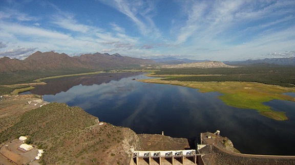
 The helipad is a 75-foot square of concrete, marked with a big, white, reflective cross in the middle. Around that is another 20-25 feet of big, dust-free gravel. A four-foot fence surrounds the whole thing (see red box). Access is from the street side only, where a double gate can open to admit an ambulance. A concrete path leads up to it so pedestrians don’t need to walk on the gravel.
As a landing zone for an event, it’s a helicopter ride pilot’s dream come true. There’s no reason at all to worry about access to the area, since everyone has to go through a gate which my ground crew keeps secured. After the first landing, no dust is kicked up into spectators’ faces or the rotor blades. The pad is flat and level and smooth.
It would be perfect if not for one thing: I had to come and go.
And that’s always been the problem with this landing zone. I only feel safe coming and going from the east (right in this photo). The fire house building is to the north and relatively new metal building stands to the south. The event is to the west and several strands of wires hang at the usual height from telephone poles between it and the helipad. The east is the only direction where I don’t have to fly close over a building or crowd of people. Of course, to the east there are also some desert trees up to 15 feet tall and a railroad track that gets freight trains a few times a day.
I’m not saying the landing zone is impossible. It’s certainly not. But it’s the kind of place where you need to keep on your toes whenever you take off or land.
The Usual Routine
Normally, the wind is coming from the north, south, or west. That’s okay with me, unless it’s howling. I’d rather take off with a tail wind and land with a headwind than the other way around. The way I see it, if I can take off with a tailwind, I’ll have no trouble landing with a headwind.
When the wind is coming from the north, I take off to the northeast and land from the southeast — quartering headwind both ways. When the wind is coming from the south, I take off to the southeast and land from the northeast. Same quartering tailwind situation.
I always park with my tail rotor facing away from the path. I don’t want to give passengers any reason to even think about walking behind the helicopter. The single member of my ground crew loads one side of the helicopter at a time. He walks two passengers from the gate to the helicopter’s left side while a third passenger (if there is one) waits at the path. Once he’s loaded the first two and closed their doors, he walks the third person to the seat behind me. Once the doors are closed, he gives me the thumbs up signal as he walks back to the path.
When he’s clear and I’ve double-checked the doors — a good habit I’m not going to break — I pick up into a hover, pivot around to face my departure path, and take off. I then do a loop around the entire town to the left. It takes 5-6 minutes. I finish off by coming in on my chosen arrival path and landing back on the pad.
This photo shows my arrival and departure paths with a few points of interest.
- The blue lines are all wires. They’re the standard height wires you find on wooden telephone poles.
- The yellow line is my departure path. I need to fly parallel to the railroad tracks until I have enough altitude to see if a train is coming. (I can’t make this stuff up.) If a train is coming, I need enough altitude to fly over it. I also need enough altitude to get across the wires on route 89 when I make my left turn.
- The magenta line is my arrival path. I need to clear the wires on route 71 on my final descent. I’ve already confirmed no train is coming, so I know I can come in nice and low over the tracks.
- Both paths avoid the desert trees growing between the helipad and the tracks.
One of the challenges to this path is the six-foot fence around the metal building south of the helipad. You can see it as blue lines in the first satellite photo. It’s only a few feet from the helipad fence and I cross over the corner of it while I’m climbing out. Going beyond the corner would bring me tool close for comfort to those train tracks with no way of knowing if a train was just beyond the building and trees.
Sounds challenging and it is. But I’ve been doing this gig for a bunch of years and I just deal with it. After all, I’ve worked with much worse conditions at other gigs. Despite the confined space aspects, this is still pretty darn good.
Add Heat
This gig is in October every year and Congress sits at right about 3,000 feet elevation. The temperature is normally in the high 70s or low 80s. Warm, but not to the point where it becomes an issue.
But not this year. During the October 2, 2010 event, my outside air temperature (OAT) gauge read anywhere from 90°F to 102°F. It was freaking hot. So hot I took my door off before I started flying and flew with a bandana full of ice cubes around my neck.
Doing the Math and Why It Matters
 Let’s do some pilot math here through the use of a density altitude chart. At 3,000 feet elevation with an outside air temperature of 35°C (roughly 95°F), the density altitude is about 6,000 feet. That means my aircraft would perform as if I were taking off and landing at a helipad at 6,000 feet elevation rather than 3,000 feet.
If you’re not a pilot, you probably don’t understand why this matters. The simple explanation is that aircraft performance drops off as altitude rises. This has to do with the density of the air. At high density altitudes, the air is thinner and aircraft simply don’t perform as well as they do at sea level.
I knew this was going to be a problem when we took off at Wickenburg at 9 AM that morning. With full fuel tanks, two people on board, and about 50 pounds of landing zone equipment, I had to pull 22 inches of manifold pressure to get off the ground. On a cooler day, 20 or 21 inches would have done it. I immediately started wondering how things would be with two or three adult passengers on board.
I found out at about 10:20 AM, when the parade ended and the passengers started lining up. The first flight was just one passenger, a friend. By that time, the temperature was already in the 90s and the helicopter felt slightly sluggish. The second flight had two passengers and that was enough. On departure, I passed through effective translational lift (ETL) right around the time I reached that six-foot fence. The resulting dip before the post-ETL power boost kicked in brought me within 5 feet of the top of that fence. I was not a happy camper.
On the next flight, before taking off, I hovered to the north side of the pad to give myself a running start at that damn fence. It made a difference, but not a big one. I could count the barbs on the top strand of wire every time we passed over it.
Using High DA Experience
I have to admit here that I was using all my high density altitude experience for every departure. In the grand scheme of things, 6,000 feet DA isn’t a lot for me. I’ve successfully landed and taken off at airports with 9,000 or 10,000 feet density altitude. The density altitude was over 10,000 feet a few years back when I departed Bryce Canyon Airport in my helicopter with three people on board.
When I flew at the Grand Canyon in 2004, I flew Long Rangers from a base at 6,300 feet with temperatures as high as 95°F. If you pull too much pitch on takeoff in a turbine helicopter, you’ll over-torque the engine and possibly destroy the transmission. If you didn’t learn the tricks for getting off the ground with a full load of German tourists, you’d be putting a helicopter in the shop with a $100,000 repair bill.
In the R44, you can pull as much pitch as you want without bothering the transmission, but there will come a point when there simply isn’t enough power to spin the blades at full RPM. When the low rotor RPM horn goes off, you want enough wiggle room beneath you to lower the collective to regain lost RPM. That isn’t going to be possible with a fence just a few feet away. So I wasn’t about to pull more pitch than the helicopter would give me. I trusted my ears to tell me when I was pushing my luck with the collective — I can always hear the rotor RPM droop before the horn goes off.
Why Full Fuel?
Now you might be wondering why I had full fuel tanks. Simple: there was no fuel at my landing zone. I’d planned to fly until I had enough for my 10-minute flight back to Wickenburg and 20-minute required fuel reserve. Since I’d be spending a lot of time on the ground, spinning between flights, I needed to start with as much fuel as I could if I wanted to maximize fly time — and profits.
The problem with this plan was that I simply did not have the performance I wanted to take three adult passengers at a time. And there aren’t many kids in Congress. As a result, I did almost every single flight with just two passengers on board, netting just a few dollars on every flight — and sweating my brains out while I did it.
Just Can’t Do It
I was down to 2/3 tanks when my ground crew guy tried to put three adults on board. The two women weren’t big, but the man was 245 pounds. Our total weight was right about at our limit for an out of ground effect (OGE) hover. I pulled pitch slowly to bring it into a hover. I was at 23 inches of manifold pressure hovering over the pad. I’d need at least two inches more to clear the fence on what was essentially a maximum performance takeoff from a confined space. And, given the conditions, I just didn’t think I had the power I needed.
All I could think of was hitting that damn fence with three passengers on board.
I set it back down and told them that either one of them needed to get off or they all needed to come back later, when I’d burned off more fuel and was lighter.
The OGE Chart
As my ground crew guy offloaded them, I consulted the pilot operating handbook (POH) to see exactly what the OGE chart said. According to the chart, it was possible to hover out of ground effect in the conditions of flight — but just barely.
You might be wondering why I consulted the OGE hover chart instead of the IGE (in ground effect) chart. After all, ground effect is in play for about one rotor diameter — in my case, about 28 feet — from the ground. The fence I feared was only 6 feet tall.
 I guess the easiest way to explain it is that the OGE hover chart is the best indicator of the most power I’ll have in the worst possible condition. It takes more power to hover than to fly and it takes more power to hover OGE than IGE. So if you want to know what the maximum performance is in a worst case scenario situation, consult the OGE chart.
(I should mention here that the OGE chart for the Robinson R44 Raven II is the reason I bought a Raven II instead of a Raven I. The Raven I OGE chart (which can be found in this post, also dealing with high DA) told me that I simply wouldn’t have the performance I needed to operate in Arizona’s relatively high elevations in Arizona’s hot weather. It was a no brainer and worth the extra $40K to have a better performing aircraft. I don’t regret my decision one bit.)
To read this chart, you follow the weight line (roughly 2,400 to 2,450 pounds; I always use the highest estimate) up to where it intersects with the temperature line (35°C) and then follow it across to the pressure altitude. In this case, it says I can hover out of ground effect at 3,000 feet, which is exactly where I was.
But what if I didn’t have the skill? What if the helicopter wasn’t properly tuned? The chart is created by test pilots with thousands of hours at the controls of all kinds of helicopters. I have about 2,500 hours, of flight time with less than half of that in my R44. Just because the chart said it was [barely] possible doesn’t mean I could pull it off. I wanted more wiggle room.
And That’s What Experience Teaches Us
Experience doesn’t only teach us how to fly better and to make the helicopter perform in difficult situations. It also teaches us to recognize when performing a maneuver or operation might not be safe.
It gives us the courage to say no, this isn’t something I want to do.
I remember one hot day at the Grand Canyon back in 2004. I was flying Copter 9 (I think), which had a reputation for being a “dog” — an under performer. The company tower controller called me on the radio to ask if I could take 4,150 pounds. The helicopter’s max gross weight was 4,200 pounds and it had been performing like its usual crappy self all day with every load around 4,000 pounds. I’d even “beeped” it a few times on takeoff — pulling a tiny bit more than 100% torque for a second or two. I didn’t think 4,150 was a good idea. I said no.
Sure, I could have tried taking a heavier load. And I could have hit the JetA fuel tank at the end of our departure area or overtorqued the aircraft. Or I could have got off fine. Was it worth trying to find out how it would all end?
Of course not. Safety first.
There are old pilots and bold pilots, but there are no old, bold pilots.
My Three Passengers
The same three passengers tried to board again 15 minutes later, after I’d burned off only 24 pounds of fuel. I told my ground crew guy I needed at least an hour. They hung around for a while, watching me come and go. All my flights had only two passengers on board — except one flight, where I took a mom and two small kids.
They disappeared while I was out flying. Later, my ground crew guy told me he’d given them their money back. I was glad.
Maybe next year, the temperature at Congress will be more seasonal. And maybe next year, we’ll bring the last 10 gallons of fuel in cans.

 The helipad is a 75-foot square of concrete, marked with a big, white, reflective cross in the middle. Around that is another 20-25 feet of big, dust-free gravel. A four-foot fence surrounds the whole thing (see red box). Access is from the street side only, where a double gate can open to admit an ambulance. A concrete path leads up to it so pedestrians don’t need to walk on the gravel.
 This photo shows my arrival and departure paths with a few points of interest.
 Let’s do some pilot math here through the use of a density altitude chart. At 3,000 feet elevation with an outside air temperature of 35°C (roughly 95°F), the density altitude is about 6,000 feet. That means my aircraft would perform as if I were taking off and landing at a helipad at 6,000 feet elevation rather than 3,000 feet.
 I guess the easiest way to explain it is that the OGE hover chart is the best indicator of the most power I’ll have in the worst possible condition. It takes more power to hover than to fly and it takes more power to hover OGE than IGE. So if you want to know what the maximum performance is in a worst case scenario situation, consult the OGE chart.