Aviation Communications

It’s not as tough as you think.

When I was learning to fly back in the late 1990s, my flight instructor babied me when it came to radio communication. He did most of the talking. Because I wasn’t forced to talk on the radio during my training, I didn’t get as much practice as I should have. As a result, my radio communication skills were weak — to say the least.

Although I really like my original flight instructor — and still stay in touch with him after all these years — he really wasn’t doing me any favors by handling communication for me. That became apparent when I went through my commercial pilot training and got my commercial pilot certificate. Although I could fly to FAA-established standards, I was a nervous wreck when it came to using the radio.

I eventually learned by doing it. After all, there was no CFI along with me to do the talking, so I had to do it. It took about a year for me to relax and even more time to realize that it wasn’t such a big deal after all.

Misconceptions

The big misconception among pilots in training is that they must use a certain vocabulary and say things in a certain order to communicate with ATC. That is simply not the case.

The goal of radio communications is to simply communicate. How you say it doesn’t matter much as long as the message gets across and two way communication is established when needed.

The Basics of Making a Radio Call

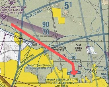
Here’s an example. Suppose I’m flying from Wickenburg to Deer Valley Airport. Wickenburg (E25) is class G, so the only talking I need to do is on unicom for position reports, etc. Deer Valley (DVT) is a busy class D airport on the north side of Phoenix. I need to establish 2-way communication before entering the class D airspace, which starts about 5 miles out from the airport.

What do I need to say? It’s pretty simple:

  • Landing DVTWho I’m talking to: Deer Valley Tower
  • Who I am: helicopter Six-Three-Zero-Mike-Lima
  • Where I am: eight miles northwest
  • What I want: landing terminal helipad
  • ATIS confirmation: with bravo

Ideally, this is the best formula, keeping things short. The initial radio call would be:

Deer Valley Tower, helicopter Six-Three-Zero-Mike-Lima is eight northwest landing terminal helipad with bravo.

But the information doesn’t have to be in that order. I could also say:

Deer Valley Tower, helicopter Six-Three-Zero-Mike-Lima is eight northwest with bravo, landing terminal helipad.

If I leave something out, there’s no reason to panic. The tower will ask for the missing information. So if I leave out the ATIS confirmation, they’ll say something like:

Helicopter Zero-Mike-Lima, verify you have Information Bravo?

Or if I left out my position, they might say:

Helicopter Zero-Mike-Lima, say position?

I’d reply with the missing information:

Affirmative, Zero-Mike-Lima has bravo.

Or:

Helicopter Zero-Mike-Lima is eight miles northwest.

Responding to ATC

When the tower responds to my initial call, all I need to do is repeat back the important part of the instructions. So if the tower says,

Helicopter Six-Three-Zero-Mike-Lima, Deer Valley Tower, report 1 mile north at or below two thousand. Plan midfield crossing at two thousand.

What’s important? RIght now, just to acknowledge that I’ve heard the instructions and will report again a mile north. So I’d say,

Zero-Mike-Lima will report one north.

Done.

I might also include mention of that altitude restriction, but I usually don’t. Why? Because the tower usually repeats it when they clear me to cross the runway. (The helipads are south of the two runways.) So they might say

Helicopter Zero-Mike-Lima, Deer Valley Tower, we have you in sight. Cross both runways midfield at two thousand feet. Landing at the terminal helipad will be at your own risk.

I’d respond:

Zero-Mike-Lima crossing at two thousand.

I don’t have to repeat the risk thing. It’s the altitude restriction that they want to hear.

Note that in my original response, I chopped Six-Three off my call sign. Although a lot of the pilot reference material says not to do this until the tower does, I have never had a problem abbreviating my call sign before ATC does.

If ATC Makes a Mistake

Sadly, its pretty common for the tower to get my N-number wrong. I can’t tell you how often they think I said “Helicopter Six-Zero-Three-Mike-Lima.” They’d respond:

Helicopter Six-Zero-Three-Mike-Lima, Deer Valley Tower, report 1 mile north at or below two thousand. Plan midfield crossing at two thousand.

If they do that, my response to them corrects them using the entire N-number again, with stress on the scrambled characters:

Helicopter Six-THREE-ZERO-Mike-Lima will report one mile north.

In which case they repeat back the N number to correct themselves; no response is necessary.

If You Make a Mistake

I can’t tell you how many times I told a tower I was X miles east when I was really X miles west. Or X miles southwest when I was really X miles southeast. It happens. It’s dumb and sloppy, but it happens. It’s not the end of the world.

If you make a mistake and it’s something you think the tower needs to know, get back on the radio and correct yourself:

Sorry, Tower, Helicopter Zero-Mike-Lima is really eight northEAST.

I usually put the stress on the word(s) that correct what I got wrong the first time. The tower will repeat it back and you don’t need to respond unless you get new instructions.

You don’t have to tell the tower about every single mistake you make. Maybe you told the tower you were 12 miles out and you’re really only 11. Not a big deal. Direction is far more important so the tower knows what direction they should be looking for you.

Leaving Out Your N-Number

It’s very important to include your N-number — either the whole thing or the abbreviated version — in every communication with a tower. I recently heard an exchange between a tower and a pilot who neglected to mention his N-number. The tower basically ignored him for two or three calls, then chewed him out over the radio. How embarrassing.

The tower was right, though. If you don’t give your N-number, the tower doesn’t know who’s talking. How can it answer and provide instructions?

I’ll be the first to admit that I occasionally omit my N-Number when I’m having a “conversation” with a tower. For example, if a tower asks a direct question:

Helicopter Zero-Mike-Lima, confirm you have information Bravo.

I might answer:

That’s affirmative.

It’s also wrong. The only reason I get away with it is because (1) I immediately answered a question directed to me and (2) I am likely the only female pilot flying a helicopter in that airspace at that moment. It’s simple voice recognition on the part of the controller. But he has every right to demand I answer properly and I have no right to expect him to distinguish my voice from anyone else’s.

Requesting a Frequency Change

Deer Valley and Scottsdale
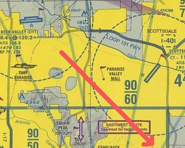
In the Phoenix area, there’s less than a mile between the Deer Valley class D airspace and the Scottsdale class D airspace. The towers know this, of course, so if you’re flying from one to the other, they usually give you a frequency change when you’re less than three miles from the airport you’re leaving. Even if you didn’t ask for it, they’ll say something like:

Helicopter Zero-Mike-Lima, frequency change approved.

But sometimes they don’t cut you loose. Maybe they forgot. Maybe they’re busy. Maybe there’s traffic in your area and they want to be able to talk to you. Who knows? It doesn’t really matter. It’s pretty handy to get an early frequency change so you can listen to the ATIS and prepare for your radio call to the next tower.

To ask for it, just say:

Deer Valley Tower, Helicopter Zero-Mike-Lima requests frequency change.

The response will likely be:

Helicopter Zero-Mike-Lima, frequency change approved. Good day.

You can now change the radio frequency while still in their airspace.

Transitioning

I can’t tell you how many times I’ve avoided airspace just so I didn’t have to talk to a controller. I don’t do that anymore. Transitioning through the edge of a class D or C or even B surface airspace is easy. Just remember the formula:

  • Transition ExampleWho I’m talking to: Scottsdale Tower
  • Who I am: helicopter Six-Three-Zero-Mike-Lima
  • Where I am: six miles west
  • What I want: transition southeast through the southwest side of the airspace
  • ATIS confirmation: with bravo

So the call might be:

Scottsdale Tower, helicopter Six-Three-Zero-Mike-Lima is six miles west with bravo. I’d like to transition southeast through the southwest side of your airspace.

If you don’t mention the ATIS, no big deal. You’re not landing there, so you don’t need it. Chances are, they’ll give you the current altimeter setting anyway. They might say something like this:

Helicopter Six-Three-Zero-Mike-Lima, Scottsdale Tower, proceed as requested. Scottsdale altimeter two-niner-niner-seven.

I usually respond with something like,

Two-niner-niner-seven, Zero-Mike-Lima.

Or sometimes I just repeat my abbreviated N-number to acknowledge that I heard them. That’s it. When I’m clear of the airspace, if the tower frequency isn’t busy, I’ll say something like,

Scottsdale tower, helicopter Zero-Mike-Lima is clear to the south.

Otherwise, I don’t bother.

Unusual Requests

Once in a while, you might have an unusual request — something beyond simply coming or going or transitioning. I had one of these a few weeks ago.

A client wanted a custom tour of the Phoenix area that included circling five different addresses. When I plotted the addresses on SkyVector to create a flight plan, I realized that I’d be passing through and circling within Phoenix Sky Harbor class B and Chandler class D airspaces. The flight required me to talk to Glendale tower on departure, Phoenix tower on transition, Chandler tower for operation in the northeast corner of their airspace, Phoenix tower again for operation in their surface area before another transition, and back to Glendale tower for landing. All within about an hour.

Flight from Hell

Even though I’m pretty confident these days about my radio communication skills, I admit that I was nervous about this one — especially since most of the addresses we needed to circle were in subdivisions filled with lots of homes that look nearly identical from the air. I didn’t want my client disappointed, so navigation was a huge issue.

What is it they say about pilot priorities? Aviate, navigate, communicate. Of the three, the flying would be the easiest part!

Amazingly, this came off without a hitch. Why? Because I remembered the primarily goal of radio communication: to communicate what you need. So, for example, when I was still 10 miles out from Chandler, I said something like:

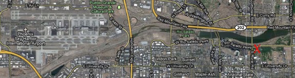
Chandler Tower, Helicopter Six-Three-Zero-Mike-Lima is ten miles northwest. We need to take some aerial photos of three targets in the northwest corner of your space. The closest to the airport is at Route 202 and Alma School.

The tower came back with:

Helicopter Zero Mike Lima, Chandler Tower. What altitude do you need?

Duh. I should have mentioned the altitude. But no big deal, huh? The tower just asked me for the information they needed. I replied:

Helicopter Zero-Mike-Lima will stay at or below two thousand feet.

To which they replied:

Helicopter Zero-Mike-Lima, you can proceed as requested. Chandler altimeter is three-zero-one-one. Report on point.

What he did was give me permission to do the job but also to let him know when I was at each location I needed to circle. I replied with my abbreviated N-number to let him know I’d heard him. Then, when I got to the first address, I said:

Chandler Tower, Helicopter Zero-Mike-Lima is on point at the first target.

To which he replied,

Helicopter Zero-Mike-Lima, thank you.

We repeated this exchange two more times. He also advised me of some traffic when I was at my second target; the traffic was at least 300 feet above me and not a factor. When I finished with the last target and departed to the north, I said:

Chandler Tower, helicopter Zero-Mike-Lima is clear to the north. Thanks for your help. Good day.

Although there was only one target in the Phoenix class B surface area, there was also another helicopter just outside the surface space, about a mile east of me, circling. The tower was busy with jets, but they also had to advise me of this traffic, which they saw on radar but weren’t talking to. Fortunately, I saw it both on my helicopter’s traffic information system (at my altitude!) and then visually. I was able to confirm that I would keep visual separation. We circled the site and departed to the north.

I like to think of this flight as my “final exam” in aviation communication. I passed.

Just Communicate

If you’re a pilot struggling with communication, relax. Magic words and phrases aren’t necessary. Just communicate. Tell the tower what you want. Believe me — they’ve heard it all. No matter how bad you think you are on the radio, there was someone worse only an hour ago.

Air traffic controllers are professionals. They deal with it. Do your best and you’ll do good enough.

And the more often you communicate while flying, the better you’ll get.

How to Extract GPS Coordinates for a Google Maps Location

It’s a lot easier than you might think.

Like most folks who depend on the Internet as a source of information, I use Google Maps a lot. But rather than use it to track down street addresses and get driving directions, I use it to pinpoint places out in the middle of nowhere that I need to visit by helicopter. There are usually no street addresses, and even if there were, they wouldn’t help much while flying. What I need are GPS coordinates.

You might be in a similar situation. You see a place on a map and, for one reason or another, you need to know its exact GPS coordinates. Fortunately, Google Maps can help. Here’s how to get those coordinates.

  1. Use Google Maps (not Google Earth) to display the location you want GPS coordinates for. In my example, I’ll use satellite view to find a dirt airstrip I know along the Verde River north of Phoenix. You could search for an address if you needed the coordinates for a street address.
  2. Google GPS Step 1Hold down the Control key and click right on the spot you want the coordinates for. A menu pops up. (You may be able to simply right click, but I’ve had limited success with that on my Mac using Firefox; Control-click always works.)
  3. On the menu, choose Center Map Here. The view will probably shift a bit.
  4. Google GPS Step 2Above the map area, in the blue bar, click the Link button. A window appears with two text boxes in it. The contents of the top text box, which are selected, includes a link to the map that you might paste into an e-mail message. It also includes the GPS coordinates, which I’ve indicated with a red box around them. Sometimes the GPS coordinates are not so obvious and you’ll need to scroll through the contents of the box to find them.

Note that the coordinates are in digital format. In this example, they’re 34.160043°N 111.727266°W. (West and South are negative numbers.) Some GPSes use this format; you can usually specify the format you want to use in your GPS’s settings.

If you need coordinates in degrees, minutes, seconds format, you’ll need to do some simple math. Let’s take a look at how it works for the first number: 34.160043.

  1. Take the whole number (34) and set it aside. That’s the degrees.
  2. Take the number after the decimal point and multiply it by 60: .160043 x 60 = 9.60258
  3. Take the whole number from that calculation (9) and set it aside. That’s minutes.
  4. Take the number after the decimal point and multiply it by 60: .60258 x 60 = 36.1548
  5. Take the whole number from that calculation (36) and set it aside. That’s seconds. Keep in mind that if you want a more precise number, you can include the decimal places after it. You might also want to round the number up or down depending on what comes after the decimal point. In this example, the number after the decimal point is 1 so I’d round down and use 36.
  6. Put the numbers you set aside together in degrees° minutesseconds” format. In this example, you’d have 34° 9′ 36″.

My helicopter’s GPS uses a degrees° minutes‘ format, so I’d stop calculating after step 2 and wind up with 34° 9.60258’.

Congratulations! You’ve made it to the end of yet another post here on An Eclectic Mind. If you got this far, you must have gotten something out of what you read. And isn’t it nice to read Web content that isn’t full of annoying ads?

How about doing something to show your appreciation? I’d love it if you’d add a comment at the end of this post to share your feedback with me and others. But I’d really love it if you’d visit my Support page and chip in a few dollars to help cover the cost of hosting this blog and motivate me to keep writing new, interesting content. It’ll only take a moment and I really would appreciate it!


The Golf Ball Drop

Good thing I don’t play golf.

Yesterday at about noon, I did another golf ball drop from my helicopter. It was my second ever. The first didn’t come off all that well.

The event was at a golf course about 3 miles off the approach end of Phoenix Sky Harbor runways 25 L/R. I’d called the tower the day before to tell them what I’d be up to and make sure it wouldn’t be a problem. (The ATC folks at Sky Harbor tower are great.) At the time of the event, planes were taking off on runway 8 (north side of the airport, farthest runway from where I was) and landing on runways 7 L/R. I was cleared to cross the extended centerline and then let the tower controller know when I was landing, doing the drop (low level), and ready to depart again. The whole time I was flying, I was listening to airliners departing from the runway; I was never told to switch to the south tower frequency.

Golf Course Location

Golf Ball Drop

Hovering over the drop zone.

I did much better at this drop than the last one. The conditions were good. The drop zone was on the driving range for a golf course in Tempe. Although there were some serious wires to the north, there were no obstructions near where I had to drop. That means I didn’t have to climb above any obstructions for the drop (which is what messed me up last time). Winds were light out of the east, so there was no pedal dancing — I was able to point the helicopter’s nose right toward the spectators for the entire flight.

Although I’d originally been told to expect 900-1100 golf balls, we only had about 400 on board. They all fit in a box. We cut three of the box’s four flaps off, leaving the drop guy, who was provided by the client, with a handle he could use to hold the box while dropping. (This was the drop guy’s first time in a helicopter. Too bad it was such a short and boring flight.)

This time, we dropped out of the door behind mine. This made it possible for me to see exactly where the balls were falling. (Duh.)

My instructions were to drop between a big red flag and a smaller red flag at the cup. The folks who ran the show expected the balls to roll down the hill from the big flag toward the cup.

Golf Ball Drop

Dropping golf balls over a driving range in Tempe.

I was in about a 150-foot hover over the drop zone. When it looked as if the balls weren’t going to roll, I hovered sideways, right over the cup. The shower of balls came much closer. I didn’t see any balls go in, but a bunch of them gathered around the cup. One sat right on its lip. There would be a winner but no in-the-cup winner.

Afterwards, I landed and exchanged the ball dropper guy for my ground crew helper, a Black Hawk pilot named Jonathan who’d come along for the ride. Jonathan took the in-flight photos you see here.

Next time, I’m sure I’ll make the hole.

Bring the Right Lens

No, a telephoto lens is probably not the right one for aerial photography.

Slot Canyon

This is the slot canyon I needed to photograph from the air. The slot is actually wide enough for an ATV to drive through; there were tire tracks in the sand. (Nosecam photo.)

Yesterday, my husband and I took the helicopter out to get some aerial photos in the Alamo Lake area. I’ve been writing for Aircraft Owner Online magazine and have a bunch of stories that don’t have photos to go with them. This flight was a chance for me to do some fun flying while getting the pictures I needed.

I set up the helicopter’s “nosecam” to capture an overall view of the area. The camera has a wide angle lens which does add some distortion to the photos, but not enough to render the photos unusable. In fact, during my recent Southwest Circle Helicopter Adventure excursion last week, I captured hundreds of very usable shots, some of which you can find here. The camera has no controls; it’s set up to take a shot every 5 seconds.

My husband also brought along his Nikon D90. I didn’t pay much attention to the lens he’d bought along. He usually uses my old favorite, an 18-85 (I think) zoom, and that would be perfect for this mission. We took both front doors off and put in the dual controls so either of us could fly while the other took photos.

I took off and we headed west. Once I’d established us in level fight, I offered him the controls. He took them. I reached for the camera.

And that’s when I saw that he’d put on a 70-210 zoom lens.

I felt my heart sink as I looked through the lens. At our 500-foot cruising altitude, it was simply too zoomed in to be useful. Sure, I could take photos of the occasional grazing cow we flew past, but there was no way I’d be able to capture the “big picture” views I needed for my articles. For that, we’d have to gain another 2,000 feet in elevation.

Sorely disappointed, I put the camera down and just watched the desert scenery go by.

Bringing the wrong lens along on an aerial photo flight is something I see first-time aerial photographers do all the time. For some reason, they get the idea in their head that things will be far away and they need telephoto power to frame them properly. In a helicopter, this can’t be further from the truth. I routinely cruise at 500 feet AGL and am willing to go as low as 100 feet (depending on the circumstances) for a photographer to get the shot he needs. Some of the best photos taken from my helicopter have been taken with focal lengths less than 50mm.

Wayside Inn

The Wayside Inn is in the middle of nowhere. And yes, those are parked airplanes in the bottom-right corner of the photo. (Nosecam photo.)

A telephoto lens is a bad choice for another reason: the longer the lens, the faster the shutter speed required to prevent blur caused by a too-low shutter speed. The rule of thumb formula is generally 1/focal length for minimum speed. So a 70mm lens would require a 1/70 second minimum shutter speed. But since our digital cameras have a 1.5 focal conversion (meaning that a 70mm lens is equivalent to a 105mm lens), that ups the speed to 1/105 second minimum shutter speed. Not a big deal on a bright Arizona day, but remember: that’s a minimum rule of thumb and I don’t think it takes into account the increased vibrations of a helicopter. (I wouldn’t shoot anything from a helicopter at less than 1/500 second without gyro stabilization.)

Departing Plane

A bonus shot captured perfectly by the nosecam after we’d landed and shut down. That’s the main rotor blade parked dead center.

When I took back the controls a while later, Mike took the camera. I think he immediately saw what I meant. He was surprised. He did take some photos — among them, some bulls locking horns out in the desert — but not many. The camera simply wasn’t properly equipped for our mission.

Fortunately, the nosecam had us covered.

Lake Powell to Monument Valley by Helicopter

Part of my Southwest Circle Helicopter Adventure.

This article was originally written for Aircraft Owner Online magazine. I write their monthly “Adventure Flying” column. I normally pull old blog posts for publication, but this time, I wrote an original piece for them. You can find it in their November 2010 issue.

Although I’m based in the Phoenix, AZ area, I spend an unusual of time at Lake Powell doing aerial photo flights for amateur and professional photographers. In September of this year, I flew a total of 20 hours over the lake with at least 20 different photographers on board. I usually get as far uplake as the San Juan River confluence, which is halfway to Monument Valley. But due to the difficulty and expense of getting aerial photo permits for Monument Valley, I rarely fly there.

The one thing that does get me to Monument Valley is Flying M Air‘s Southwest Circle Helicopter Adventure. That’s a 6-day excursion by helicopter that starts in Phoenix and spends a night at Sedona, Grand Canyon, Lake Powell (at Page), Monument Valley, and Flagstaff before returning to Phoenix. I don’t do this trip often — frankly, it’s quite costly and there aren’t many folks who want to spring for it — but I happened to do one in October 2010. In fact, as I’m typing this on my laptop, I’m looking of the window of my room at Goulding’s Lodge at the first light striking the famous monuments of Monument Valley.

On this particular trip, I rigged up a GoPro Hero camera on my helicopter’s nose. Although I used this “nosecam” to shoot video on the first day of the trip, the mount introduced too much vibration to make the video usable. For the remaining days of the trip, I switched over to still photos. The camera automatically shoots a high resolution image every 5 seconds as I fly. With 720 photos per hour, I usually get a few good shots on each leg of the trip.

Wednesday was one of the most scenic legs of the trip. We flew from Page Airport (PGA) up Lake Powell to the San Juan confluence and then east to the airstrip at Goulding’s Lodge in Monument Valley (UT25). On board with me were my two excursion guests and all of our luggage for the 6-day trip. I pack the luggage on and under the seat behind me and sit my guests in the two right seats (front and back) so they get the same view. I then fly to put the best views on their side of the aircraft.

We lifted off from Page at about 2:30 PM. The ASOS reported wind at about 8 knots out of the north, but it sure didn’t feel that strong. I made my radio call and then departed right across the runway, heading uplake. A Citation jet called a downwind a few moments later; we caught sight of him high above us as we crossed the airport fence.

Departing PGA

Our shadow as we crossed the runway at Page Municipal Airport.

It was a beautiful day, with high, thin clouds tracing lazy lines across a clear blue sky. The October afternoon sun bathed the landscape with a soft light that illuminated the red rock cliffs and buttes, cast shadows in the canyons, and accentuated the blue of the water. Sure, the light was too harsh for the aerial photographers I usually take around there, but for my passengers and me, it was great for taking snapshots of our surroundings.

The first canyon we crossed was Antelope Canyon, which is just east of the airport. Normally, I just buzz across it, but the tour boat was inside the canyon, so I made a turn to the left so my passengers could get a photo of it. I didn’t circle, though. I’m extremely conservative with fuel on the fourth and fifth days of the excursion, since there’s no fuel between Page, Monument Valley, and Flagstaff (or, in this case, Winslow). I need every drop of fuel I have on board to get to my Day 5 destination on Thursday with required reserves on board.

Antelope Canyon

Most people see Antelope Canyon from the inside, where it’s a masterpiece of sandstone swirls carved by wind and water. But this is the view I see most often.

We continued uplake, passing Antelope Point Marina and the mouth of Navajo Canyon. I made a position call a mile north of iconic Tower Butte and changed from the Page airport frequency to the uplake frequency (122.75). I repeated the call on that frequency and got into a discussion with the returning tour pilots. They’d be coming my way at 5,000 feet; I’d stay out of their way by flying at 4,500 feet.

The tour traffic is a major concern for anyone flying at Lake Powell. It’s a very good idea to learn the tour routes, altitudes, and reporting points they use before exploring in your own aircraft. There’s nothing scarier than flying the lake and seeing a plane flying where you don’t expect it, especially if it’s not on frequency or doesn’t know where it is in relation to the usual reporting points. Ten minutes with a tour pilot and a chart at Page Airport is enough to get the basics.

We slipped between Dominguez and Boundary Buttes at the south end of Padre Bay and continued uplake. Winding canyons opened up on our right. I pointed out a cluster of kayaks near a powerboat in a canyon with water as smooth as glass. In the main channel, you could clearly see the wind on the water. Not enough to make whitecaps, but gusty enough to see round patterns of movement appear and disappear across the water surface.

Dominguez Butte

My usual uplake route takes me between Dominguez and Boundary Buttes. In the far left of this photo, you can see Padre Butte, referred to by local pilots as “submarine.” Navajo Mountain looms in the distance.

We passed the south side of Gregory Butte and Last Chance Bay as two tour planes flew by overhead. Last Chance is a long, wide canyon with steep sandstone walls. It’s a long boat ride to the end where there are a few sandy spots suitable for houseboat parking. Distance to parking and the cost of fuel are part of what keeps the canyon free of traffic, even during busy summer months. On this October day, however, the whole lake was quiet; I don’t think we saw more than 20 or 30 boats.

We flew over the main channel of the lake as the canyon narrowed. One of my passengers pointed out Dangling Rope Marina and asked me about it. I told her what I knew: it was a marina only accessible by water. There were no roads in or out. I then told her a story about our stop there 20 years before on a houseboating trip. How I miss cruising the lake in a houseboat!

Lake Powell from the Air

Over the main channel of Lake Powell just uplake from Last Chance Bay. The canyon walls rise about 800-1,000 feet off the water’s surface here.

We were nearing the mouth of the canyon that would take us to Rainbow Bridge. As I flew, I’d been listening to the radio and knew there was a female pilot in the area. I also knew there was another tour plane behind me, on its way to “the bridge.” It’s a tight squeeze in the canyon and my challenge is always to stay as low as possible to ensure my photography clients can get the shots they need. Over the years, I’ve perfected my approach.

The female pilot was just leaving the area when I reached the mouth of the canyon and turned in. I flew up the canyon at 5000 feet, telling my passengers what to look for as we flew: the dock, the trail, the giant stone arch of Rainbow Bridge. I was busy keeping an eye on the mesa to the right of the helicopter. On a day like that one, with occasional gusts of wind, I wouldn’t get any closer than 200 feet from it’s edge. I verbally pointed out Rainbow Bridge when I saw it, keeping both hands on the controls. We flew past and they snapped photos. I circled around the back, assuring the pilot behind me that I’d stay at or below 5000 feet until I was clear of the area. Then, when abeam the bridge a second time, I broke off to the left and climbed out toward the San Juan Confluence.

Rainbow Bridge

This wide-angle shot gives you an idea of how tricky the area around Rainbow Bridge is. I get very close to that mesa top. Can you see the bridge in the photo?

The trickiest bit of flying I’d have to do on the entire trip was behind me.

I climbed to 6500 feet to give my passengers a good view of the twists and turns of the San Juan River just upstream from the confluence. Then I punched in my user waypoint for Goulding’s Lodge, adjusted course, and headed east over the eroded desert terrain south of the San Juan River.

San Juan River

The San Juan River twists and turns dramatically before meeting the Colorado.

We were east of Navajo Mountain now and the area was riddled with water-carved canyons, windswept rocks, and stunted trees. Below us, here and there, were two-track roads leading back toward the river. One of the roads looked very well maintained, although there was no sign of any homesteads or other reason to use it.

We flew over the top of No Man Mesa, where two or three ranches are scattered. A pickup truck drove slowly along a two-track toward one of the ranches. We saw a herd of horses and a flock of sheep tended by a dog before crossing over the top of the mesa and beginning our descent toward Monument Valley. The famous monuments started coming into view as we rounded the edge of a cliff face.

Off No Man's Mesa

A wide canyon cuts across the desert just past No Man Mesa. While not as beautiful as the Grand Canyon, it offers a glimpse of what the Grand Canyon may have looked like before it became grand.

I switched to the Monument Valley frequency and heard several tour planes making calls. I leveled off at 5500 feet and flew directly over the first paved road we’d seen since leaving the airport. Ahead of us, at the airport, I could see three tour planes launch, one after the other. One crossed overhead in front of me, the others climbed out beside me and likely crossed behind me. All of them were returning to Page the quick way. They’d be back within 30 minutes; we’d taken 60.

Before landing at Gouldings, I always make a quick loop around the western part of the Monument Valley Tribal Park. That day was no different. I climbed to 6000 feet and followed the road into the park. Once I reached the visitor center area, I banked left toward the Mitten buttes. I flew between them, on a route the tour pilots refer to as “splitting the mittens.” Then I banked left again and headed back toward Goulding’s.

Splitting the Mittens

The two Mitten Buttes (East and West) are iconic Monument Valley images.

Monument Valley

I restrict my quick loop around Monument Valley to the west side of the park to minimize noise impact on the ground.

As we came in for a landing, a small herd of horses, spooked by the sound of my helicopter, galloped across the desert east of the airport, kicking up fine red dust.

Landing at Monument Valley

Monument Valley Airport has just one way in and out. Not the kind of airport where you want to overshoot the runway.

It had been a good flight with few bumps or unexpected challenges. Later, in my hotel room at Goulding’s Lodge, I was pleased with the quality of the images my Hero camera had captured. What a great way to document a flight.

Note to Pilots: If you do plan a trip to Goulding’s Lodge, remember that the airport there is private and for use by Goulding’s guests and tour clients only. Go to Goulding’s Web site at www.Gouldings.com to learn more about restrictions regarding airport use.