GPSTrack Turns My iPhone into a GPS Logger with Map

Here’s what an aerial wildlife survey looks like from the air.

This morning, I finished up an aerial wildlife survey with a client. It was the seventh day of this work I had this month. We only flew for 90 minutes. Our goal was to comb through an area with scattered bunches of ponderosa pines, looking for bald eagle nests.

GPS Track IconLast night, I prepped by downloading an app called GPSTrack for my iPhone. This $1.99 investment “allows you to use the GPS receiver in your iPhone or iPad to show your current location and create a log of your travels.” It can show a map of your track as you travel, updated in real-time. The resulting tracks can be exported via e-mail in GPX and KML formats.

Basically, it turns your iOS device into a moving map geologger.

Eagle Nest HuntI gave it a whirl for the first time this morning. As the helicopter was warming up, I turned it on and enabled tracking. Then I stuck the phone into my shirt pocket and flew. Ever once in a while, I pulled it out to take a peek and, sure enough, it not only laid down my track as I flew, but it had a trip computer that totaled miles and calculated current and average speed.

I flew for about an hour and a half, following the directions of my clients. That consisted of a lot of zig-zagging and looping around. I followed electric lines and flew around lakes. I flew up and down drainages and along cliff faces. My speed varied from about 30 to 80 knots. I flew over 130 miles, all within an area 10 miles wide by ten miles long.

We looked at the tops of a lot of trees. (We saw three bald eagles — one of which had just caught a fish and was eating it on the shore of a lake — but no nests.) When we landed back at the airport, I turned off tracking. Later, I took this screen shot of the completed track.

I also exported the track by tapping a button and sending the two track files (GPX and KML) to myself via e-mail. Opening the KML file on Google Earth resulted in an image like this:

Track in Google Earth

And here’s a closeup of some flying around one of the lakes. (No, I wasn’t drunk; just following instructions.)

Another GPS Track

Overall, I’m extremely impressed with the app. It did a far better job than I expected and was well worth the money I paid for it. In fact, I’m thinking that right about now, companies like Garmin and Magellan should be getting pretty nervous — it wouldn’t take much to add features to this app that match those in something like my Garmin GPSMap 60cx. Add the ability to tap and add waypoints and anyone with an iPhone (or iPad, for that matter) that includes a GPS wouldn’t need a standalone GPS unit anymore.

The only thing I’d like to see with this software is a different map — topo or terrain. I have very little use for road maps and don’t like the level of detail in satellite images when shown at the magnification for speeds I fly at (usually around 100 knots). I put in a request to the app’s author and he responded that it was on his list of things to do. I bet that if he sold a lot more copies of this app, he’d be motivated to keep improving it. (Hint, hint.)

If you give it a try — or have tried other similar software you like — take a moment to use the comments form or link to share your opinions. I’m always interested in GPS-related software.

Flying Wildlife Surveys

Probably some of the toughest flying I’ll ever do.

On Friday, I finished my fourth straight day of flying for a wildlife survey job. It was…well…exhausting.

Tight Spot

Eagles live in places like this.

This work is, by far, some of the trickiest and most dangerous flying I do. In this particular survey, we were looking for raptors — birds of prey. We were interested in nests. Nests are generally on high, rocky crags, normally on cliff faces. In order to see them, you need to be close. So I’m basically flying 25 to 50 feet off the side of cliffs, slow enough for the observers to look for bunches of twigs crammed into a rock shelf.

Cliff faces are not all at the same altitude. Some are high, some are low. Some are high and low at the same rock formation, requiring multiple passes at various altitudes. The high ones might be a few hundred or even thousand feet off the desert floor. Or they might be adjacent to a ridge or inside a canyon. Or inside a box canyon. The low ones could be 50 feet off the desert floor.

If the observers see a nest, I need to stop and hover so they can get a good look at it. They mark a location on a GPS and take photos. I have to keep the helicopter relatively stable in an out-of-ground effect hover.

We start with full fuel and fly until we need more. On Tuesday, one leg ran 3.4 hours. That’s 3.4 hours of constant, intense flying. I flew a total of 31.6 hours over the course of four days.

That’s an overview of what it’s all about. For my fellow helicopter pilots, I want to go into some detail. Read on.

Operating Inside the Shaded Area of the H-V Diagram

Height-Velocity Diagram, R44I wrote about the “deadman’s curve” about two years ago. If you’re a pilot, you should be familiar with it, perhaps by its less sensational name, “The Height-Velocity Diagram.” It indicates the airspeed/altitude combinations for which it is likely impossible to perform a successful autorotation in the event of an engine failure.

In other words, if you are operating in the shaded area of the diagram and have an engine failure, you’re probably going to crash.

I operate in the shaded area when I do cherry drying. After all, I’m about 20-30 feet off the ground, flying at about 5 to 10 knots. Of course, when I dry cherries, I do have all those soft, cushy trees under me. An engine failure means a totaled helicopter and some damaged trees, but I’d likely live to tell about it.

Not so with this flying. I’m operating all over that shaded area. Under me is rock — all kinds of rock. Boulders, gravel, sandstone, basalt — more kinds of rock than I know. It all has one thing in common: it’s very hard. It will not cushion a fall. Worse yet, most of it is on hillsides or ridges or equally uneven ground. So not only would we hit the hard ground, but we’d likely tumble. It would be very ugly.

I try not to think about it.

Settling with Power

Probably the biggest challenge is avoiding settling with power in out of ground effect (OGE) hovers. We were operating at altitudes ranging from 2,000 to 7,500 feet MSL, at temperatures ranging from 12°C to 25°C. With full fuel — which I had to take each time we refueled just so we’d have a full three hours of flight time between refuelings — we were within 100 pounds of max gross weight. (There were three of us on board.)

Settling with power, which is also referred to as vortex ring state, occurs when the helicopter descends into its own downwash. It’s an aerodynamic condition caused by enlarged rotor tip vortices. (You can read more about it on pages 11-5 through 11-6 of the Rotorcraft Flying Handbook.) Recovery is usually pretty easy: just get some lateral motion to break the helicopter out of the vertical descent. Unfortunately, you might lose quite a bit of altitude before you can recover. So while recovery from 2,000 or 3,000 feet AGL — where flight schools normally practice — isn’t a big deal, recovery from 100 feet AGL probably isn’t going to be successful. The key is to avoid settling with power — to realize that you’re descending before your descent slams you into the ground.

Settling with power, by the way, is the biggest danger to inexperienced pilots or pilots operating underpowered aircraft during aerial photo missions. It’s the main reason Robinson issued Safety Notice SN-34, which recommends a minimum of 500 hours PIC time for all pilots conducting aerial photography missions. I discussed it as it related to an R44 accident here. It’s also the reason I believe anyone doing serious aerial photography in an R22 should have his head examined.

OGE Hover Chart, R44The OGE Hover chart for my Raven II shows the expected performance in zero wind. Fortunately (and unfortunately) we did not usually have zero wind. The wind was blowing at sustained speeds up to 15 knots with gusts up to 25 knots. It was also blowing from different directions, depending on where we were flying — did I mention that we covered hundreds of square miles of land during the four-day period? So the challenge was knowing where the wind was coming from, trying to point into it whenever possible, and holding a steady hover while the observers did their thing.

Of course, sometimes it just wasn’t possible to point into the wind while maintaining a hover. The worse was when the wind was behind us, gusting, trying to blow the tail one way or the other. Then I’d be dancing on the pedals to keep us straight. Once in a while, I’d run out of left pedal when I was a lot closer to a cliff face than I wanted to be. Or sometimes — especially on the last day when the wind was really howling — the wind blowing over the hills and rock faces around us was setting up some nasty pockets of turbulence that offered no wind consistency at all. I’d be working the controls, keeping us as steady as possible and realize that I just couldn’t hold the hover. I’d apologize to my clients as I veered away from the cliff face, gathering speed as I descended. Then I’d come around from the other direction and, if I were lucky, the wind and turbulence would let me get the 30 to 60 second hover I needed. Or not. And then I’d have to come around again.

Escape Route

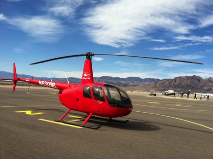
In this photo from Wednesday’s flight, my observers are examining the rock face on the left and I have a perfect escape route toward the desert floor on my right.

The real key was to make sure there was always an “escape route” — a place to go if I began to settle. I preferred having that escape route on my right, where it would be easy to peel away with a clear view of where I was going. I also preferred having at least a few hundred feet of empty space beneath us in that direction. But sometimes I had to operate in a tight area between two cliff faces or beside a cliff with a ridge beneath us or beside a cliff only 50 or 100 feet off the desert floor. There was no room for error.

Tight Spot

By contrast, in this area, I was not only flying directly into the sun, but there’s a ridge line beneath me and mountains to my left and ahead of me. The only escape route is down to my right, after I’ve cleared the ridge. (The adrenaline-pumping spot I refer to in the narrative was much tighter than this.)

I got into a tight spot once with a cliff face on my left and a ridge line only 50 or so feet beneath us on my right. The only escape route was behind me, back between two arms of the mountain. The wind was wicked weird in that spot, blowing from the other side of the cliff and I was dancing hard on the pedals to keep us pointed the way we needed to point. When we started to settle, for a moment, the helicopter would not go in the direction I wanted it to. We were descending right into the ridge. I felt a small rush of adrenaline just before we finally started to move where I wanted to go. It was probably the closest I came to a mishap during the entire job.

Obstacles, Birds, and Traffic

Tower and Cliff

This shot gives a good idea of how close we came to cliff walls; mind you, this was shot with a very wide angle lens. The tower in the distance had 9 or 12 unmarked guy wires.

Did I mention the obstacles? Of course I mentioned the cliff faces and ridge lines — those were par for the course. But there were also a few towers, including one nasty tall one with guy wires.

And then there were the birds. In some cases, the eagles we saw would be perched on a rock, watching us fly by. We didn’t phase them in the least, even when we got close enough to look them in the eye. Other times they were flying nearby, unafraid of us. One came dangerously close to my main rotor disc as we flew past. Another decided that we were invading his territory and did what my clients said was a display to defend it: he flew straight up into the air, above our altitude, then tucked his wings under and dove straight down past us. This bird did this at least six times, giving us a show that would have made great footage for Animal Planet. As my clients said, “That’s one pissed off bird.”

Traffic wasn’t a big deal. We were operating near a tour helicopter area and, because of that, I had to monitor the tour traffic frequency. We were seldom high enough to be in their path and, when we were, we were hovering beside mountains where they shouldn’t be with passengers. I suspect they might have seen us poking around the mountains — a tiny red dot on the desert landscape far below — but I kept quiet and just listened, trying to figure out where their reporting points were. I wonder if they made the connection when they saw us back at the airport during our refueling stops.

My passengers got a real kick out of seeing them fly across the desert above us, one after the other, as if they were playing follow the leader.

Fatigue

I’ll be honest — since my days flying at the Grand Canyon, I’ve seldom flown more than 5 or 6 hours in a day. And just about all my previous long days of flying have been either for tours or point-to-point cross-country trips — easy stuff. For this job, I was flying 8 or more hours a day, starting not long after dawn.

Restful Flying

Long stretches of high-speed flight over open desert was time for rest.

To be fair, some days had a considerable amount of point-to-point flying. For example, on the last day, I had to fly to New Mexico in the morning and return to Arizona in the afternoon — those two cross-country flights were just over 2 hours each. Other times, we needed to fly from the refueling point to the survey area or speed across the survey area from one likely habitat to another. I considered that flying my “rest” time.

The actual survey flying was intense, requiring both hands and feet to be firmly on the controls, making constant inputs. And although I know I can fly the helicopter with just two fingers on the cyclic and collective, it’s not easy to do when sudden gusts of wind or turbulence are trying to yank to cyclic out of your hand. In other words, I applied my “cyclic death grip” — a surefire way to tense up the rest of my body for the duration.

Compounding matters is that with both hands busy, it was impossible to grab a sip of water. I had to wait until we’d finished an area and were cruising to the next to get a drink. Sometimes that would be 30 minutes or more. The whole time, we’re flying in the desert. When facing into the sun, the cockpit got hot. Not brutally hot, like it would be in the summer, but hot enough to sweat. The helicopter’s vents were wide open, but with airspeeds typically less than 30 knots, there wasn’t much air coming in. Dehydration was a real danger.

Each flight, I did my best to maximize fight time between refuelings. That meant knowing exactly when to turn back. On our first day, when we were relatively close to the airport, the low fuel light came on just as we were coming in over the airport for landing. I managed to get 3.4 hours of continuous flight time on full tanks.

But as time went on, my fatigue started to wear me down. On the second day, I told my clients I wanted to go in for fuel when we could have easily flown for another 20 or 30 minutes on the fuel we had. I needed a break.

That pretty much set up a pattern for the rest of the job. We’d start very early in the morning and do two flights of about 3 hours each, then take a break for lunch. After lunch, I got my second wind and was good for the rest of the day.

Experience that Counts

Overall, the experience was very good for me as a pilot. It required me to stay in tune with my helicopter and make it do exactly what I needed it to. It built flying skills and gave me plenty of practice using the skills I already had.

As I was doing this work and watching the tour pilots fly by overhead, it struck me how unfair the experience numbers game is. Any helicopter pilot can do what those guys do — fly from one airport or landing zone to another, high over open desert on a predetermined route on a beautiful spring day. They’re taxi drivers of the sky, shuttling people from one place to another. They’re not facing the Deadman’s Curve or concerns about settling with power. They’re not dancing on the pedals to maintain heading in a hover, fighting turbulence, keeping an escape route in sight at all times. There are no obstacles, few birds, and all the traffic knows exactly where you are. There’s no need to engage the cyclic death grip; two fingers give you all the pressure you need to stay in control.

Yet because these guys are flying turbine helicopters on their tour routes, their flight time is worth more than mine. To them, I’m just a “Robbie ranger,” not even worth treating with courtesy when I fly into “their” airspace. In their minds, they’re hot stuff, turbine helicopter pilots, tomorrow’s great aviators. They haven’t got a clue about real helicopter flying.

Worse yet, their turbine flight time is more valuable to employers than my time. I can fly circles around these guys in my little piston helicopter, but because they fly turbines, they’ll get jobs I can’t qualify for because I don’t have those turbine hours. It’s not fair, but it’s a fact of life — one I have to deal with if I ever do decide to get a job working for someone else. Until that day comes, however, I’ll be satisfied building real flying skills in the aircraft I fly.

And hopefully, by sharing what I learn here, some of those guys will get an idea of what they’re missing.
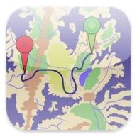
My Epiphany about Clients and Jobs

I finally realize that the key to success in my business is good clients with good jobs.

At Boulder City
N630ML at Boulder City, NV during a recent charter flight.

I’ve owned my helicopter charter business since October 2001, when I started it with a commercial pilot certificate and a Robinson R22 Beta II helicopter. In 2005, I got serious: I upgraded to a Robinson R44 Raven II and got a Single Pilot Part 135 certificate from the FAA. So I count January 2005, when I took delivery of the helicopter, as my serious start date.

But it was just this past week that I had an epiphany about my business and the key to its success.

Let me tell you about it.

My Original Strategy

Since day one of my business — even in the R22 days — my goal was to maximize flight time, with the idea that it would also maximize revenue time. This caused me to do several things that were really not in the best interest of my company:

    How Groupon Fits In
    I just had to add this side note because it really does apply. Groupon is perfect for businesses who want to sell a ton of products or services below their cost. (Why anyone would want to do that is beyond me.) Businesses justify the deep discounts that Groupon requires as an “advertising expense.” But it’s likely to be the most expensive and least effective means of advertising a business could try. Sure, you’ll get lots of customers, but will you ever see them again without a Groupon certificate in their hands? I wrote extensively about Groupon here and here.
  • Appeal to the lowest common denominator. I assumed that one way to maximize flight time was to make flights cheap enough for most folks to afford something. In the beginning, I actually offered 15 minute flights. Trouble is, it takes just as much time to preflight and postflight the aircraft for a 15-minute flight as a 2-hour flight. So I would spend two hours of my day to get 1/4 hour of revenue. (What was I thinking?) Later, I upped the shortest flight to 30 minutes.
  • Offer rides at outdoor events. This is part of the lowest common denominator concept, but in this case, I offered a bunch of short rides — usually 8-10 minutes each — during one or two day events. When things were good, I’d do great. We had lots of really good events. When things were not good, however, I’d lose money, sometimes spectacularly. I recall our Lake Havasu Spring Break disaster, which cost about $2K in setup, fees, and repositioning time for a total of 9 rides. I pulled the plug after just two days. (To this day I harbor bitter feelings about the little shit kids on spring break, interested solely in beer and boobs.)
  • Make “special deals” on pricing. I cannot tell you how many clients attempt to weasel down my pricing by telling me about their budget. Photographers and real estate people are notorious for this. For years, I’d “work with them” to keep my prices low, just to get their business.
  • Donate flights to charities in exchange for free advertising. Let’s face it, who really looks at sponsors in the booklets at those charity events? The last straw was when I discovered that my company was not mentioned in a sponsor booklet at all.
  • Spend money on ineffective advertising. I tried newspaper advertising, magazine advertising, tour guide advertising, and even foreign language tour guide advertising. I tried trifold brochures and rack cards in racks I had to pay to be placed in. I tried radio advertising. I tried Google Adwords and Facebook ads. Although I don’t have exact numbers, I am absolutely certain that I spent at least five times more than what I received in revenue through customers gained by these efforts. I didn’t even get that many calls. The few that mentioned the rack cards were either looking for a tour over the Grand Canyon (which I can’t do) or trying to buy a cheap (less than $50/person) helicopter ride.
  • Work with hotel concierge staff. Part of a concierge’s job is to find things for their guests to do. Helicopter flights are a good option. There are four drawbacks to working with hotel concierge staff:
    • No matter how much printed material you provide to describe your tours in detail, they never seem to understand what you can do. Evidently, once they file the 16-page, full-color Information Package I send them, they can’t be bothered to consult it.
    • If you’re not in their face every week or so, they won’t remember you. I don’t have time to schmooze 20 different concierges all over the Phoenix/Scottsdale area every week.
    • Staff changes; the person you schmoozed last week may have moved back to Minnesota this week, so now you’ll have to schmooze her replacement. Honestly, I can’t keep track of them all.
    • They won’t even consider recommending you unless they get a good sized piece of the action. Like 20% off the top. My margins are so thin that if I paid that, they’d make more money than me.

The underlying goal of all of this was to get any work I could, just to have work. This is how I thought it should be. Seems to make sense, no?

Strategies Change

As I’ve already hinted, I began to get smart about my strategy as time went on.

  • I stopped offering short, cheap flights. I now have a one-hour minimum for any flight.
  • I stopped doing rides at events unless the event is within 30 minutes flight time of my base or guaranteed to draw a good-sized crowd of families.
  • I no longer offer special deals. My price is my price. Take it or leave it.
  • I no longer donate flights to any charity. (Hell, it’s cheaper to just write them a check.)
  • I slashed my advertising budget. Now I rely on word of mouth, rack cards placed in free places, and a Web site that apparently Googles pretty well.
  • I cut concierge commissions to 10% and, other than sending out the Concierge Package at the beginning of the season and answering their occasional calls, I don’t contact them at all.

You’d think that drastic changes like these would reduce the amount of business I get. It didn’t. In fact, I seem to get more calls and more conversions of those calls to real business.

Think Different

Still, the amount of business I got was barely enough to support my helicopter operation. I certainly couldn’t quit my “day job” as a writer. There’s a lot of competition in the Phoenix area, with at least three helicopter flight schools that have many aircraft and qualified pilots at their disposal. Clearly, I needed to set myself apart from them.

One way I did this was by offering day trips and multi-day excursions. This was something my competition was not willing to do — they simply couldn’t take a helicopter offline for a whole day or multiple days.

Another way I differentiated myself from others was to agree to fly as needed for any kind of mission I was permitted to do. You need me to chase a race car around a track 50-100 feet off the ground? I’ll do it. You need me to fly alongside a cliff face at 20 knots? I’ll do it. You need me to fly sideways low over a golf course from tee to green? I’ll do it. The flight schools won’t. That’s “dangerous” flying and they’re not willing (or able due to insurance limitations) to let their pilots fly like that.

Just being willing to say yes, was a great way to increase my business. Still, my overall strategy was to fly as much as possible for whoever hired me to fly. That mean focusing on the quantity of jobs and not on the quality.

My Epiphany

Wildlife Survey

Nosecam image from one of my recent wildlife survey flights. The work is difficult and dangerous, requiring me to fly alongside cliff faces hundreds of feet off the desert floor.

And that brings us to this past week. I was hired by a client to do a four to five day wildlife survey. I’d flown for this client three times before, most recently in February. In each instance, it was a one-day job with some intense flying. But this year, the client hired me to fly multiple missions, some of which would last multiple days.

This week’s job lasted four days. It would have gone a fifth, but we worked our butts off to finish what could have been two days’ work in just one very long day. (I took off from my base before sunrise and returned after sunset.) In that four days, I flew 31.6 hours. That’s more than I normally fly in a month.

And guess what? I’ve got another three days for the same client company next week. And another one or two days in the beginning of April. And possibly another two or three days in May.

That got me thinking about how much revenue comes from a job like this. A very good amount.

And that got me thinking about similar jobs that bring in a good chunk of revenue from consistent sources, like my cherry drying work, which actually made my company profitable for the past two years in a row.

It also got me thinking about clients like this — repeat clients that call me out for jobs again and again. Like the aerial photography clients I work for at Lake Powell and the people they directly or indirectly send my way.

It got me thinking that although the work I do for these people is a hell of a lot more challenging than flying tours around Phoenix or taking a couple up to Sedona for the day, it’s this work that earns real money. The money to not only keep my company afloat, but the money to make it profitable.

And that got me wondering why I’m still chasing around the odd flying job, dealing with difficult one-time clients and their sometimes outrageous needs, and, in general, doing flying jobs I simply don’t want to do.

These thoughts, one after another, formed my epiphany: a business like mine thrives on the work it does for a handful of good clients. Rather than trying to attract and please one-time clients, I should be working harder to find the good repeat clients who appreciate what I can do for them and rely on me to get the job done.

Now if you’re a business person and have already reached this conclusion, please don’t think poorly of me. Maybe I’m a little dense. Maybe I just didn’t see the big picture until now. But now that I’ve seen it, I’m looking at my business model in a completely different way.

Flying M Air’s Arizona season ends in May. Next season will be very different.

Making Documents Portable with a Scanner and iPad

For those documents you really want to have with you all the time.

From the very beginning, I embraced my iPad as an ebook reader. I have books stored in all three ebook reader apps: iBooks, Kindle for iPad, and Nook for iPad. But it didn’t take long for me to realize that the iPad could also be used to reference books and other documents I already had or could create in PDF format.

I use GoodReader for this. I’m not saying its the best PDF reader for iPad, but I like it. One of its best features is the ability to synchronize with DropBox. I can create folders in DropBox, fill them with PDFs or other compatible document formats, and see them on my iPad. And, of course, I can also see them on any computer I use to access my DropBox account.

What I’ve found is that many software manuals and other user guides are available online as PDF format files. So now, on my iPad, I have a copy of the 300+ page user guide for my new Nikon D7000. And Dragon Dictation. And Final Cut Pro. And dozens of other software programs and devices I use regularly but don’t know as well as I could.

Yesterday, I took this a step further: I scanned all 191 pages of the Robinson R44 Raven II Pilot’s Operating Handbook. Yes, the manual for my helicopter.

No, I don’t plan on reading it while I’m flying. I’m required to have an up-to-date copy on board and I do. This is for consulting when I’m on the road. For example, suppose I’m doing a photo flight with a client and need to consult the performance information for a certain combination of load, altitude, and temperature. The charts are in the book. Rather than get my butt out to the helicopter, I can consult the book on my iPad, in the comfort of my office, hotel room, or client meeting.

ScanSnap S1100191 pages is a lot to scan and I admit I never would have attempted it with my old flatbed scanner. But last week I bought a ScanSnap S1100 portable scanner. Although it only takes a page at a time, its feeder considerably speeds up the scanning process. I was able to get the whole book scanned in about 20 minutes. (Yes, it would have gone quicker with a duplex model, but that’s not what I bought.) I saved the resulting PDF to Evernote, which performed optical character recognition (OCR) on the document to make it searchable on Evernote. And I copied the PDF file created during the process to my DropBox so it would sync to my iPad.

I’m hoping that more and more organizations see the benefit of distributing documentation in PDF or ebook format. Although Robinson currently distributes Safety Notices and the like as PDFs on its Web site, manuals are conspicuously missing. I’m not sure if it’s because they want to sell these things or because they’re worried about people consulting older copies that might be floating around on the Internet. (I plan on updating my copy when new pages become available; I think I can modify a PDF’s pages with Preview. It’s in my best interest to keep the book up to date.)

Until then, I’ll create my own PDFs of the documents I need to consult when I’m on the go.

So You Want to Be a Helicopter Pilot, Part 5: Check Your Attitude at the Door

Attitude is everything.

You think you’re a hot shot because you’re learning to fly helicopters? Check that attitude at the door. It won’t do you any good if you plan to make flying a career.

Attitude is everything when it comes to any career. A cocky, overconfident attitude will not help you in training and it certainly won’t help you get your entry level job — likely as a flight instructor — when your training is done.

Be open to what your instructor and other knowledgeable pilots have to say. If you don’t understand something, admit it and work with your instructor to learn. Don’t be afraid to ask questions. Show respect for your CFI, chief flight instructor, flight school employees, other students, and FAA examiners. Act mature. (This isn’t high school, grow up.) Be helpful and cooperative. Don’t be a whiner.

Beyond the Flight School Environment

Attitude also extends beyond training and into your jobs.

Just the other day, while flying in the high-traffic area around the Hoover Dam, I had the displeasure of conducting a useless radio exchange with a tour pilot. This little twerp probably had half the flight experience that I have, yet he talked down to me in a sarcastic manner that was obviously his [failed] attempt to prove how much smarter he was. The radio exchange wasted bandwidth and provided little useful information about what could have been a traffic conflict. It was clearly more important for him to try to intimidate me than to provide me with the information I needed to avoid his aircraft, such as position, altitude, and flight path.

Yet only moments later, another pilot operating nearby communicated exactly what he was planning to do and even offered to wait a minute or two until I was clear of the area.

Which one had the better attitude? Which one do you think other pilots would want to fly with? Or employers would want to hire?

Attitude Extends to Safety, Too

And it’s not just a positive attitude that will help you achieve your goals. It’s a safe attitude. If you don’t conduct yourself as a safe pilot, you will simply not move forward in your career.

Back in 2009, I had a run-in with a tour pilot in Sedona. He was upset that I’d parked my helicopter in the spot across from his at the airport. Apparently, he liked that spot kept free so he could fly through it on departure. To “show me a lesson” he departed nearly right over my passenger’s heads as we waited for him to leave the area. His action was foolish and dangerous. I reported him to the airport manager and the FAA. I later learned that this same pilot had demonstrated his bad attitude at the local FSDO within earshot of one of the inspectors. It was the pilot that was taught a lesson that day.

Accidents like the one at Grand Canyon West in 2001 are teaching employers the importance of their pilots flying safely. The accident pilot had a history, backed up with videotape, of performing aggressive maneuvers during tour flights.

One of the [past] passengers stated that there were particularly exciting episodes during the tour that were frightening to some of the others. As part of the tour, they flew over a site that was used in the commercial motion picture film Thelma and Louise, and the pilot pointed out the cliff. … During the return to LAS, the pilot asked if they wanted to know what it was like to drive a car off of a cliff. She stated that they all said “no” to this question; however, he proceeded to fly very fast toward the edge of the cliff and then dove the helicopter as it passed the edge. The passenger reported that it was “frightening and thrilling at the same time but it scared the others to death.”

On August 10, the pilot and six passengers were killed; the other passenger received serious burns on most of her body that have likely destroyed her life. The NTSB report’s probable cause was:

the pilot’s in-flight decision to maneuver the helicopter in a flight regime, and in a high density altitude environment, in which the aircraft’s performance capability was marginal, resulting in a high rate of descent from which recovery was not possible. Factors contributing to the accident were high density altitude and the pilot’s decision to maneuver the helicopter in proximity to precipitous terrain, which effectively limited any remedial options available.

Evidence shows that the pilot may have been attempting to perform the “Thelma and Louise” maneuver when the aircraft crashed. (You can read the details of this accident to learn more by downloading the full NTSB report as a PDF.)

You can bet that if there are any questions about your attitude regarding safety, you simply will not get hired as a pilot.

Start Now

Getting into the habit of having a good attitude should stick with you throughout your career — and your life. Start now, before you even begin your search for a flight school.

Next up, I’ll remind you why flight training is like any other school.