What a difference a day makes!
– Day 1: The Road to Mazama
– Day 2: Mazama to Colonial Creek
– Day 3: Colonial Creek to Baker Lake
– Day 4: Baker Lake to Mount Baker
– Day 5: Mount Baker to Chilliwack Lake
– Day 6: Chilliwack Lake to Hozomeen
– Day 7: Hozomeen to Copper Creek
– Day 8: Winetasting My Way Home
I slept like the dead. Again. Not a single vehicle drove by during the 12+ hours we were parked there.
The first thing I noticed when I woke up was that it was light out. The second thing was that the sky was clear. And then I remembered being half-awake in the middle of the night and looking through the sunroof to see stars.
Where did that mountain come from? It wasn’t there last night.
I looked out the back door. There was a snow-covered peak out there, just beyond the trees. I later realized that it was Mount Shuksan.
And then I realized that there was a pretty good chance I’d be able to see Mount Baker from Artist Point only a few miles away. In first light.
I sprung into action, getting the water boiling for my coffee while I got dressed. Penny didn’t stir. She probably thought I was going to spend some time writing, as I had every morning. But when I started putting my shoes on, she knew something was up. Only a few minutes later, the Turtleback was buttoned up and we were back in the truck with hot coffee and a piece of almond danish from Trader Joe’s, heading back up the mountain.
We passed a rig almost identical to mine parked between my campsite and the bee yard, right in the first spot I’d noticed on the way in.
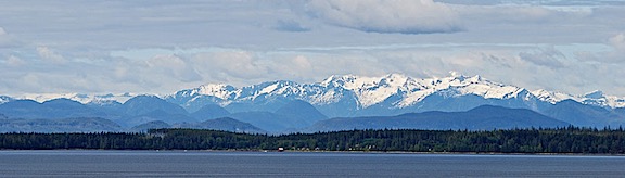
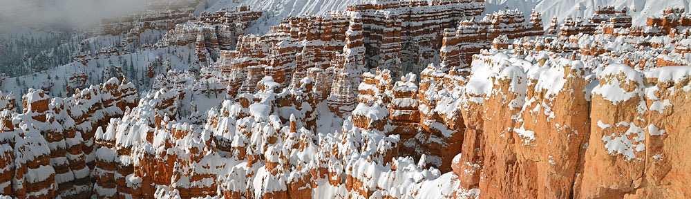
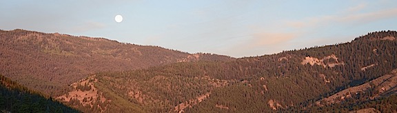
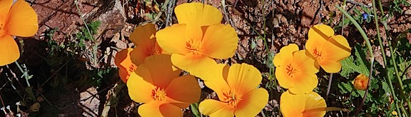
Mount Baker, Revealed!
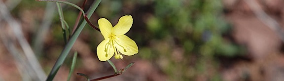
I stopped at Picture Lake again. The water was absolutely still, with a thin mist rising off the surface into the cool morning air. And there, to the southeast, just like it was supposed to be, was Mount Shuksan.
I parked and walked right to the spot where I knew the reflection would be. It was there. It was perfect. I snapped several shots from several different places with my cell phone and my Nikon. I recorded a video and shared it with Facebook friends. honestly wished they could all be with me. I’m such a sucker for reflection views.
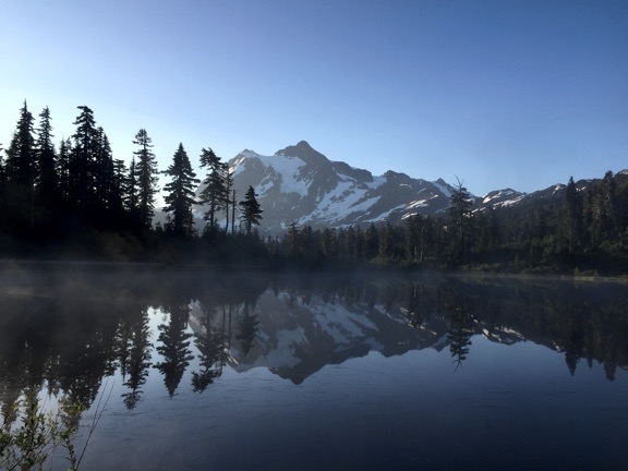
Mount Shuksan reflected in Picture Lake.
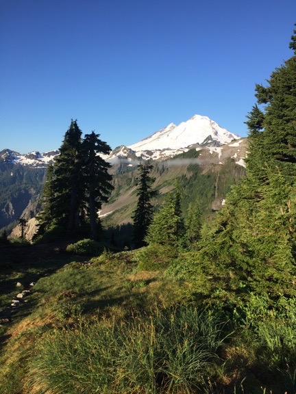
I finally got to see Mount Baker.
I continued up the road, all the way up to the Artist Point parking area. I got glimpses of Mount Baker along the way. I got out with my camera, planning to take a short walk to the viewpoint. I almost took my coffee with me. But I’m glad I didn’t because I wound up doing the entire Artist Point hike again. This time, I got to see the mountains around me. I was away from the car for more than an hour. Penny went back to sleep.
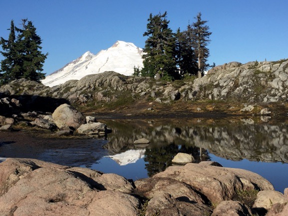
The top of Mount Baker reflected in a snowmelt pond atop Artist Point.
When I got back to the parking area, I chatted with a ranger who was cleaning out the restrooms. I told her where I’d spent the night. She told me that if I’d gone all the way to the end of that road, the area opens up with incredible views of the mountains. Plenty of room to camp and turn around. Next time.
I moved the truck to a parking spot on the other side of the lot, backing it in so the back door faced right out to Mount Baker. There was another rig similar to mine parked nearby. While I got the water going for another cup of coffee, I chatted with the owner of the rig. He had a bicycle rack on the front of his truck and I wondered if it would be strong enough to support my new dirt bike. We got to talking about camping with our rigs and he told me that he and his wife had parked right there overnight. “There are no signs that say you can’t,” he pointed out. He was right. I could have stayed right there.
I had my second breakfast sitting out on my new chair, overlooking Mount Baker. Coffee, granola, greek yogurt, and the blueberries I’d picked over the weekend. Is it the view that made it taste extra special? Or the fact that I felt exhilarated after the previous day’s dismal weather doldrums?
After breakfast Penny and I loaded back up and headed down the mountain. I stopped again at Heather Meadows and took some photos of the area from alongside a small pond — more reflections, of course — and from the warming hut at the edge of the valley. I didn’t stay long. I was ready to move on.
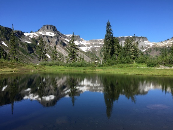
Reflections at Heather Meadows. I did mention I was a sucker for reflections, didn’t I?
My next planned stop was Chilliwack Lake Provincial Park in British Columbia. Penny and I were going to Canada.
Good Day, Eh?
The trip down the mountain was uneventful. There was some road work that delayed us for about 20 minutes, but I filled the time catching up on the news and checking the weather and our route.
We’d cross the border at Sumas, WA near Abbotsford, BC. I had my passport card — a credit card sized passport good for crossing into Canada or Mexico by land — and documentation for Penny’s shots. I stopped to top off the tank with diesel in Sumas before getting on line to cross; I wasn’t sure if fuel prices would be higher or lower on the other side and figured I’d rather take care of it in the U.S. Then we drove up and waited on line.
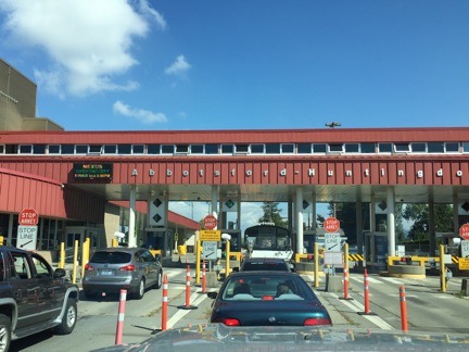
Waiting in line at the border.
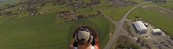
When it was my turn, the border guy took my card and asked a lot of questions. Where did I live (Washington), what did I do for a living (helicopter pilot), was I coming to Canada to look for work (no), where was I going (some parks along the border), was I meeting anyone in Canada (no), had I ever been fingerprinted (yes), for what (concealed weapons permit), what kind of guns did I own (Beretta and shotgun), why do I have a Beretta (I got it when I lived in Arizona for protection; I live alone), did I have a gun with me (no), why not (I didn’t think it was allowed), did I have any ammo with me (no), how long had I had my truck and camper (December for truck, April for camper), was I leaving anything behind when I left Canada (no), was I selling anything in Canada (no), did I know everything on board my camper (yes), was I bringing any animals (my dog), did I have paperwork for vaccinations (yes). Those are just the ones I remember. It took a long while. I wonder whether it has anything to do with the last time I went to Vancouver, which was for my old work. I made the mistake of saying I was working and they almost didn’t let me in. Did they put a black mark next to my name? Who the hell knows?
He finally gave back my passport card and told me I could move on. “Enjoy your stay,” he said. I was just glad to have passed muster.
My cell phone worked fine in Canada — I’d turned on International roaming — and I asked Google to direct me to Chilliwack Lake. Then I made my way onto the Route 1 freeway (or whatever they call it in Canada) eastbound. It was amusing to hear Google give me directions in kilometers and meters instead of miles and feet. As if my brain had somehow switched to the metric system when I crossed the border. (I assure you, it did not.)
A while later, I was off the highway and on a back road through farmland. I stopped at a place called the Farm Store to buy some fresh corn. I wound up buying some excellent goat brie, balsamic sea salt, a loaf of bakery bread, and an ice cream cone. That’s when I discovered that (1) my credit card worked fine and (2) the $75 of Canadian money I had with me was “antique.” I had a paper “loonies” and two paper “toonies” — pardon me if I spelled either of those wrong — neither of which are printed anymore. The bills I had were also larger than the new money and the new money has a clear section across each bill. Canadians apparently hate it. A woman offered to buy my loonie and toonies; she said she had a friend whose grandson collects “old money.” I like encouraging kids to do something other than watch TV and play video games, so I traded her for a brand new $5 bill. A couple who observed the whole transaction wanted to know where I got that old Canadian money. “Canada,” I told them. “A long time ago.”
We got back on the road and continued east along the Chilliwack River, passing through a few towns along the way. Then the road settled into a relatively straight drive through a valley with occasional signs reporting how far away the park was. I put the truck in cruise control, following another truck with a pull trailer about a half mile ahead of me. The speed limit was 80 kph and I had to use my reading glasses to read the fine print on my speedometer to see what that was in mph (about 50).
At Chilliwack Lake
The pavement ended at Chilliwack Lake Provincial Park. I turned right into the campground after the trailer in front of me.
The campground was really a collection of smaller campgrounds, each with several loops. Like so many park campgrounds in the U.S., you could choose your own site. But unlike park campgrounds in the U.S., this one had an “attendant” who would come collect the fee: $22 or about $18 US.
If you’re wondering how I measure privacy while I’m camping, it’s basically the same as I measure it at home. Can I get dressed/undressed without closing the blinds? Can I talk in a normal tone of voice without being heard? Can I relax or sleep without being woken by someone else’s conversation? Do the names of my neighbor’s misbehaved dogs and/or children remain unknown to me? If the answer to all of those questions is Yes, I have the privacy I want.
I equate staying in a campground to living in a subdivision. While it is possible to get the level of privacy I need, it’s not easy. It’s a lot easier to get privacy when you stay someplace more remote — which explains, in part, why I live on ten acres of land two miles down a gravel dead-end road.
I was hoping to get a site along the lake so I went there first. No luck. I pulled into a site near the lake, shut off the engine, and even got Penny out. But I looked at my surroundings — campers with kids (!) on either side of me and behind me with absolutely no privacy. I couldn’t stay there. To hell with the lake. I needed quiet and privacy.
Our campsite at Chilliwack Lake. On a whim, I put out the awnings for the first time. With a table close to the camper, this one would make a decent shelter, considering its size.
So we got back in and kept driving. I wound up in a heavily wooded site not far from the campground host. There was no one behind me, dense trees on the driver’s side, and enough trees for privacy on the passenger side. I backed my rig all the way in, right beside the picnic table and fire pit. All I saw out the back and back side windows were trees. That was as good as it was going to get.
I took out my portable grill and set it up on the picnic table, then went about making lunch. I put Penny was on her leash and left her car bed near the table. Then I sliced up some of the Japanese eggplant from my garden, cutting each one lengthwise. I brushed each cut side with olive oil mixed with Spike seasoning. (I prefer Mrs. Dash garlic flavor but hadn’t remembered to bring any.) I laid them on the grill, skin side down, and turned down the flame. With the lid closed, they baked to perfection. I had some of that goat brie and fresh bread, then scraped the meat of the eggplant off the skin and added it to the bread. Delicious.
The attendant came by; she was an older, heavyset woman who wanted to make sure I wasn’t staying more than one night because the site was reserved for the weekend. When I assured her I was just there for the night, she wrote up a receipt and parking pass and I paid her with $25 in Canadian bills, getting two large coins as change. She also gave me a map of the area, which I sorely needed if I wanted to find the hiking trails I knew were nearby.
I spent a little while working on a blog post about the previous day’s travels. I’d fallen asleep too early that night to get any writing done and had rushed out in the morning. If I didn’t catch up, I’d get too far behind to write up each day. As I mentioned in another blog post, I’m trying hard to get back into writing regularly, so it was important not to skip a day.
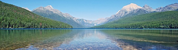
Lindeman Lake
The campground map included some information about local hikes. Post Creek to Lindeman Lake, which is the hike I’d seen when I did some research last week, was the one that interested me. According to the map, it was four kilometers with a 215 meter elevation gain. Rated moderate.
This is a family favorite and is known as the “Crown Jewel” of the park. This beautiful crystal clear lake offers many spots for summer campers to cool off or backcountry tenting pads.
Sold to the American who can’t convert meters to feet!
I had established the other day that I was good for an average elevation gain of 500 feet per mile. The hike up to Thunder Knob was just under 400 feet per mile and it was tough for me. The 4 km hike was 2-1/2 miles or 1-1/4 mile each way. That was fine. Short, even. But my brain didn’t process the elevation gain properly. It got stuck on 215 as feet, not meters. Turns out, 215 meters is 705 feet. That’s quite a climb in what turned out to be less than a mile.
Of course, I didn’t know that when I first started out. Family friendly hike! Rated moderate! Piece of cake.
Penny and I hiked to the trailhead along a very nice, mostly flat trail called the Trans-Canada Trail, which goes right through the campground. (It actually passed about 100 feet behind my campsite.) From there, we walked down the road to the parking area for the Lindeman Lake trailhead. At least part of this walk must have counted toward that 4 km because a sign at the trailhead said it was 3.4 km round trip to the lake.
We started off through the woods alongside Post Creek. It was very pleasant.
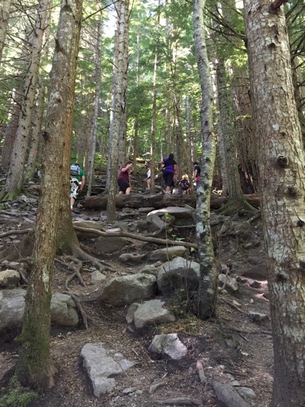
A typical portion of the trail to Lindeman Lake. This family was in front of me for about half the hike. I caught up several times and finally passed them about 1/4 mile from the lake.
Until it narrowed to a dirt path and started to climb. Steeply. Up a boulder- and log-strewn hillside.
There were red reflective markers nailed to trees along the way. They were necessary. Without them, people would not have been able to stay on the trail. It was basically a scrambling hill climb.
For almost a whole mile.
I actually did remarkably well. I look back on my physical condition five years ago, before I lost all that weight, when I spent most of my time sitting around, waiting for something — anything — to happen. (My life was pretty dull in those days.) There’s no way I could have done this hike back then. It would have killed me. But now, although I still don’t do uphill climbs very quickly, I have the energy to do it. I even passed some people on the way up. (Okay, so it was a family with four kids under the age of five and an older woman walking with a cane.)
It was hard, sweaty work, but it was still enjoyable. Why? Because it was in the woods and it was cool and there was the constant sound of running water nearby. And the smell of the woods and fresh running water. And the people were so friendly. And the lake at the end of the hike was everything the map blurb had promised.
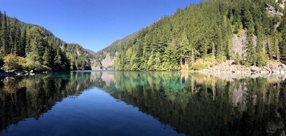
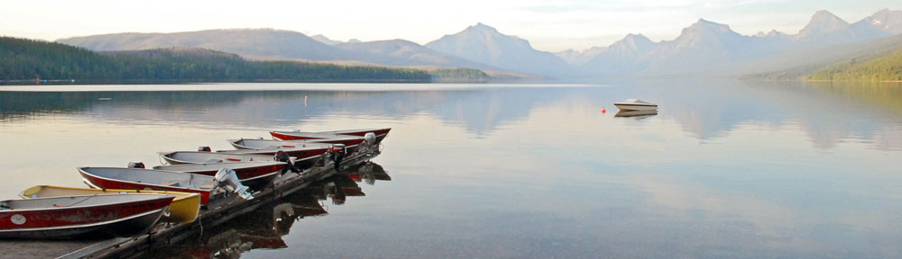
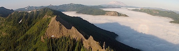
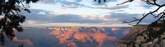
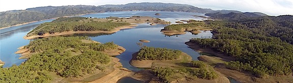
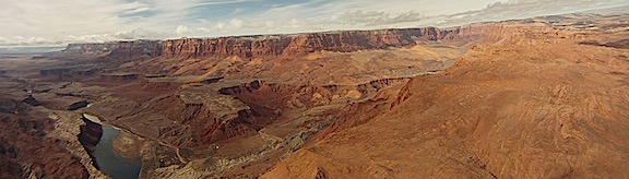
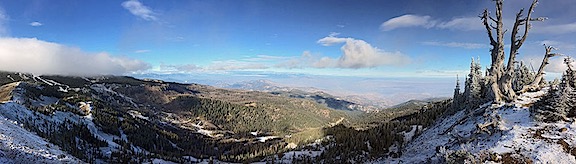
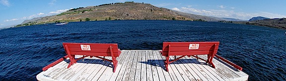
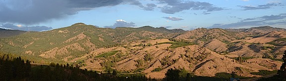
A panoramic shot of Lindeman Lake, taken from the beach near the campsites.
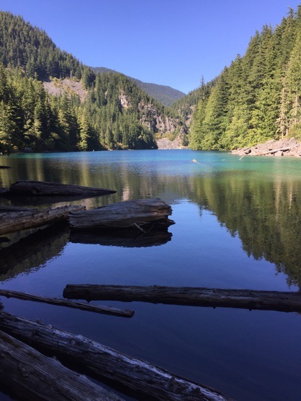
Like most lakes in the Pacific Northwest, this one had a logjam at its outlet. Post Creek flowed from here past the trail we took to the lake.
It was a beautiful lake. Long and narrow in a valley surrounded by trees and rockslides and cliffs. There were wooden tent platforms built in groups nearby. Camping lakeside here would be amazing. Once you got all the way up there with a pack on your back.
I didn’t go swimming, but one of two guys who arrived right after me did go in. He said it wasn’t that cold as he got started but then made that noise people make when they get into very cold water when he popped up after fully submerging. He didn’t stay in very long.
Penny and I hung out up there for about 20 minutes. Then we headed back. I motored. I always do downhill. It’s that gravity assist. I did enjoy the flat, wide trail for the last 3/4 mile of the hike.
Back at the campsite, I wasted no time getting into the shower. There’s nothing that feels better than a nice warm shower right after a hot, sweaty hike. And clean clothes. Also good.
Dinner and a Blog Post or Two
I spent another hour or so out at the picnic table, finishing up the blog post I’d started before heading out on the hike. Then, as it started to cool down, I retreated indoors with Penny, heated up some leftovers for dinner, and kept writing. I wrote up most of the day by the time the sun had set.
Ibuprofen. For the first time on this trip, it was absolutely required. My legs are very sore.
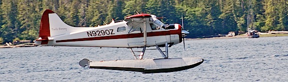
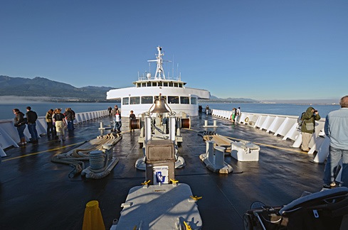 Although the sky was clear in Port Angeles, we hit fog within 15 minutes of departure. The crew shooed all passengers away from the bow of the boat and we went inside. We filled in our immigration paperwork and found a comfortable place to sit. I was feeling more than a little queasy from the rocking of the boat, but that cleared up soon enough. So did the fog. We went back out on deck as we came into Victoria Harbor. A seaplane was just landing. It was another beautiful day.
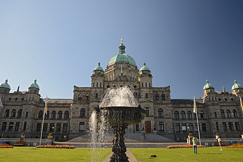 First up was the
 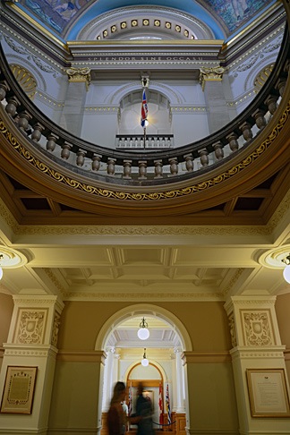 We were pleased to learn that the building was open to the public and wasted no time exploring the public areas inside. The building, which was completed in 1898 and restored in 1973 is in magnificent condition, full of wonderful architectural touches. I picked up the self-guided tour booklet but didn’t really consult it much. It was nice to simply wander around, from room to room, although I do wish we’d taken the guided tour.
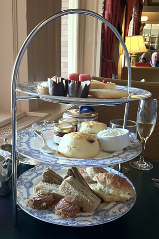 At 4 PM, we headed back to the Empress for tea. Despite our shabby appearance — I was wearing my usual henley t-shirt and jeans and Mike was similarly dressed — they sat us at a table by the window where we could look out at the harbor and watch the people go by. We started with a pair of champagne cocktails. Our waiter was excellent, recommending a tea that suited both of our tastes — I prefer mine without milk; Mike floods his with milk. Then he brought the customary three-tiered plate of goodies, including sandwiches, scones, and sweet treats. I’ve had afternoon tea about a half dozen times and this one was, by far, the best. Highly recommended.