Tips for Long Cross-Country Flights

A few things I’ve learned during many hours of cross-country flying.

Note: A version of this post originally appeared in AOPA’s Hover Power blog. If you’re a helicopter pilot, you owe it to yourself to check in there regularly to read great articles written by experienced helicopter pilots.

Because I take my helicopter where the work is, I often do long cross-country flights between my permanent and various temporary bases of operation. (After a lot of careful consideration, I’ve decided that it’s safer and more cost-effective to fly the helicopter from point to point than to buy a custom trailer and tow it.) I’ve been making cross-country flights in excess of 500 miles since 2004 and, for six consecutive years, made an annual round trip between the Phoenix area (where I lived) and north central Washington state (where I now live) for cherry drying work. Nowadays, I make an annual round trip between north central Washington and the Sacramento area for frost control. I flew solo on about half of these long flights; the other half was usually spent with a low-time pilot building PIC time at the controls while I tried not to be bored (or sometimes sick from PIO—long story for another time).

I flew home from California in late April. It was another solo flight, one that I’d been looking forward to mostly because I would be doing all the flying. And, instead of the 5-6 hour direct flight, I planned to fly west and then north up the California and Oregon coasts before turning inland again. Total flight time would be about 6-7 hours.

CA Coast
My first look at the California coast on a recent flight from the Sacramento area to Washington State.

Although the flight wasn’t as pleasant and uneventful as I’d hoped, I’m not complaining. But it did remind me of some tips I could share with other pilots preparing to do long cross-country flights.

Planning the Flight

Whether you plan to file a flight plan (which I recommend doing) or not, it’s important to plan for the flight. This pretty much goes without saying. In addition to the usual things to check in advance–weather, fuel availability, TFRs, route options–consider the following:

  • Make your flight segments shorter than they have to be. Sure, Robinson Helicopter claims I can get 16 gallons per hour in my R44 so I should be able to fly 3 hours (less 20 minutes reserve) between stops. But do I really want to fly that long without a break? Probably not–especially after those first two cups of coffee. Yet I’ve seen more than a few flight plans that had us in the air as long as possible.
  • Don’t just study your route before the trip—study everything around it. How many times have I tried to fly up or down the coast, only to be forced inland by a typical “marine layer” of fog? Too many to count. I’ve learned to study my route and alternate routes that would be easy to get to if I needed to change course.
  • Know where the fuel is along the way. Do you think you could make a planned fuel stop if you hit 30 mph headwinds that weren’t in the forecast (or flight plan)? This happened to me on my April flight. I was lucky that there were several airports with fuel along my planned route so I could stop sooner than expected.

Preparing for the Flight

Once you’ve planned the flight, you can prepare the aircraft for conducting the flight.

  • Gather and prepare your charts. If you use paper charts, mark them up with your intended route and fold them with the route easy to access. Then stack them in the order of use. That’s how I used to do it when I used paper. Sure beats fumbling around one-handed. Fortunately, we’re in the 21st century and have tools like Foreflight to provide accurate, up-to-date charts. Make sure you’ve loaded and updated all the charts you’ll need. Use the flight planning tools to mark your route. Then make sure you’re fully charged up and, if necessary, have backup power available. A backup device is handy, too. I use, in order: Foreflight on my iPad, Foreflight on my iPhone, and a panel mounted Garmin 430 GPS.
  • Make an airport and frequency list. I don’t do this much anymore–Foreflight makes it easy to get this info on the fly–but when I used paper charts, I also made a list of all the airports along the way that included frequencies for CTAF (or tower) and AWOS/ASOS (or ATIS). I could then program all the airport codes into my Garmin 430 as a flight plan and make frequency changes as I flew from one airport to the next.
  • Bring oil. I use W100Plus oil in my helicopter. It isn’t exactly easy to find. That’s why I usually bring along a quart for every expected fuel stop. That’s not to say that I’ll use it all, but it’s there when I need it.
  • Pack snacks. I always have a small cooler on board for long flights and do my best to fill it with ice (or frozen water bottles) and good snacks before I go. Even if you planned a meal stop along the way, circumstances might prevent you from making that stop. Maybe you had to change your route. Maybe the restaurant closed 30 minutes before you arrived. Or maybe the restaurant that was supposed to be a quarter-mile south is really more than a mile and a half from the only airport gate on the north end of the field. Bringing beverages like water or Gatorade-like drinks is also important. You don’t want to get dehydrated.
  • Pack an overnight bag. If you weren’t planning an overnight stay, pretend you were. A change of clothes, toothbrush, and credit card can make an unscheduled overnight stop a lot more pleasant. And if you think roughing it might be necessary, consider a sleeping bag or bedroll, either of which can make sleeping in an FBO–or the helicopter–a lot more comfortable.
  • Pack an emergency kit. I’ve spent so much time flying over remote areas that I forget that many pilots don’t. My helicopter has an emergency kit under the pilot seat that includes a first aid kit and equipment like fire starters, a signal mirror, a “space blanket,” energy bars, water, and so on. If weight is a factor–and it certainly is in my R44–you’ll have to limit what you bring. But some essentials can save your life if you’re forced to land in the middle of nowhere.
  • Make sure any required power supplies, cables, or batteries are handy. If you rely on electronic devices for navigation, you’d better make sure you’ve got back up power for them. My iPad’s battery can’t survive a 7-hour flight with the screen turned on and the GPS running. I use USB cables hooked up to a power supply to keep the battery charged. If you have a battery-powered GPS, make sure you have a spare set of batteries.
  • Set up your tunes. I listen to music or podcasts when I fly solo. My aircraft’s intercom system automatically cuts the music sound when a radio transmission comes through. Handy.

During the Flight

It’s during the flight that your preparation will really pay off. If you’ve done everything right, you’ll be prepared for anything.

  • Open your flight plan. I recommend filing and opening a flight plan for each segment of the flight. Again, with a tool like Foreflight this is very easy. I can open and close a flight plan with a few taps on my iPad screen. This beats the frustration of trying to reach Flight Service on the radio in a mountainous area when only 700 feet off the ground.
  • Remember that your flight plan is not carved in stone. I can’t tell you how many flight plans prepared by pilots who were accompanying me went out the window before the second fuel stop. Stuff happens–usually related to weather–and changes are a fact of cross-country flying life. The only time I’ve ever done a long cross-country flight plan exactly as planned was on one trip from Wenatchee, WA (EAT) to Phoenix, AZ (PHX), and that’s because our straight line route across the Nevada desert didn’t have any other options for fuel stops. We had to do it as planned.
  • Know when to pull the plug and wait it out. Weather an issue? While scud running is something we’ve all probably done at one time or another, it probably isn’t something we should be doing. Tired? Tired pilots make mistakes. When low visibility, severe turbulence, or simple pilot fatigue makes flying dangerous, it’s time to set the ship down and take a break. If you did all your homework before the flight, you should know whether there’s an airport nearby to make the wait a little more comfortable. I remember unplanned overnight stays in Rosamond, CA (not recommended) and Mammoth Lakes, CA (which would have been nicer if I’d been prepared for snow).

Experience Is Everything

Low Clouds
Hard to believe that only a few hours after hitting the coast I was forced inland by low clouds and rainy weather.

My April flight was a mixed bag. It started with a beautiful but slightly hazy dawn just west of Sacramento, a gorgeous morning on the coast, moderate turbulence with strong headwinds, low clouds, hazy coastal weather, drizzly rain, more low clouds, even lower clouds (and scud running), and bumpy air on a cloudy day. If you’re interested in details, you can read about it in my blog. Although it isn’t common, it is possible for me to have a perfectly uneventful cross-country flight of 500 miles or more in a day.

If you do enough long cross-country flights, planning and conducting a flight becomes second nature. I’m always thinking about what’s up ahead and working on ways to get more information about alternative routes when things aren’t looking as good as you want them to. I’ve occasionally used my phone to call AWOS and ATIS systems at airports I think might be along a better route. I use radar in Foreflight to get a feel for how weather is moving and where it might be better or worse than I am. I’ll change altitude to avoid mechanical turbulence. If I have to do any scud running, I do it slowly and carefully, always aware of exactly where I am and where I can go if things get worse.

It’s all about planning and preparing and using your experience to handle unexpected situations as they come up. After a while, there’s very little than can surprise you.

Cross Country Flight: Sacramento to Seattle and Wenatchee

A look back at a memorable flight.

Since the winter/spring of 2013, my helicopter has spent two months each year in the Sacramento area of California on a frost control contract. I fly the helicopter down in late February and fly back in late April. I usually take along a fellow pilot who does most of the flying to build R44 time and shares the cost of the flight. Most of these people are relative strangers and although they’re usually nice guys or gals that I stay friends with after the flight, I admit that I prefer flying with people I already know pretty well. So this spring, when it came time to start thinking about that return flight, I started thinking about who I could invite to join me.

The answer hit me like a lightning bolt: of course I should invite my friend Don.

Don’s been a pilot for much of his life and has flown airplanes and helicopters. I don’t know how much time he’s logged, but I’m certain it’s more than my 3,300 hours. I also know he has tons of cross-country experience, including helicopter flights between the Seattle area and Alaska.

Why Don?

You might be wondering why I’d invite such an experienced pilot when there were so many low-time pilots who’d likely jump at the chance to fly with me on a six to eight hour cross-country flight. There are three reasons.

First, Don is a good friend I’ve known for years. He and his wife were very supportive during my crazy divorce, and you know what they say about a friend in need. He’s easy going and has a good sense of humor. I knew I’d enjoy spending time with him.

Don't Helicopter at PHX
Don’s helicopter on the T3 Helistop at Sky Harbor Airport in Phoenix in 2009. After I shared my experience approaching and landing at the helistop, he often picked up and dropped off visitors there. Later, in October 2012, he dropped me off there when I was off on one of my many trips.

Second, Don had owned a helicopter very much like mine — in fact, it was only six months newer — which he’d kept in his garage at his Seattle area home. About two years ago, he sold it. I knew he hadn’t flown much since and probably missed it. He would appreciate the flight; surprisingly, not everyone I’ve invited to fly with me on a long flight has.

Third, because Don already had so much flight time, he’d actually share the flight with me. After all, I like to fly. When I fly with other pilots, they’re paying for the privilege of every minute of stick time they can get. They don’t want to share the stick with me and I don’t feel comfortable asking them to.

So I texted Don to see if he was interested. The response came almost immediately. Hell, yes!

Getting to the Helicopter

Don has two homes, one in the Phoenix area and one in the Seattle area. He made arrangements to be in the Seattle area on the day we’d go south to fetch the helicopter.

I booked my flight from Wenatchee to Sacramento, which included a plane change in Seattle. Don booked his flight from Seattle to Sacramento on the same flight. Since Don always flies First Class, I bought a First Class ticket, too. When he booked his flight, he got the seat right next to mine.

We met at the gate for the Seattle to Sacramento flight. I’d been at the airport for two hours and had treated myself to a breakfast of trout and eggs at Anthony’s. Don had also been at the airport for a while and had breakfast.

I had Penny with me, of course. She’s always excited when she sees me take out her airline travel bag. She’d gotten back into the bag at the gate before Don arrived and he didn’t even realize I had her with me until we boarded.

There wasn’t supposed to be breakfast on our flight, but there was; a nice yogurt and granola bowl with fresh fruit that would have gone nicely with the Bloody Mary I couldn’t have. (First Class on Alaska Air really is worth the extra cost. Can’t say the same for all airlines.)

On the flight, we chatted, ate, read. Time passed quickly. We were on the ground by 10:45 AM. With no bags checked and a quick exit from the plane, we were at the curb waiting for our Uber driver by 11 AM. Penny seemed happy enough to be out of the bag, sniffing around someplace she was pretty familiar with. After all, we’d flown to Sacramento quite a few times over the past four years.

It was about a 30 minute ride to the airport where my helicopter had been parked on the grass for two months. I settled up my bill for parking and said goodbye to the staff there. Don preflighted and installed the dual controls while I folded up the cockpit cover and tie downs and went to work setting up my GoPro. That’s when I realized that I’d left the Mini SD card for the camera at home. Duh-oh! There would be no video from the flight.

California to Washington

We’d discussed our route briefly on the flight down. Neither of us was in a hurry and both of us leaned toward a flight up the coast, which would add about an hour to the flight time.

Marine Layer
Here’s a shot of the marine layer on the coast of Oregon that forced us inland during a flight from Seattle to Wickenburg with my wasband in 2009.

My experience with flying the coast was varied. What I’d learned was that if I could get to the coast, I probably wouldn’t be able to follow it all the way up. The California and Oregon coasts are well known for their “marine layer” clouds. Although I’d flown the coast many times in the past, from Los Angeles to the Columbia River between Oregon and Washington, those damn clouds always made an appearance, forcing me inland so I’d never covered more than one or two hundred miles at a stretch. Last year, when I’d flown north by myself, planning on a coastal route, clouds with rain moved in not long after I hit the coast, forcing me inland for a dreary flight with more scud running than I like to do.

But nothing ventured, nothing gained, eh?

We followed Cache Creek west into the hills. I did the flying. I’d been wanting to fly Cache Creek all winter, but truck troubles had messed up my March plans and I wound up spending most of the month home instead of with the helicopter. I hadn’t flown nearly as much as I wanted to. This was my chance to get flying out of my system, flying a familiar and loved route. Somewhere in the hills, I turned the controls over to Don and he steered us over Clear Lake. Although the weather was clear where we were, there were clouds to the west (of course) and neither of us were sure whether they came into the coast or were off over the Pacific.

After flying up Highway 101 for a while, we decided to try heading west to see if we could make the coast. So we followed one of the canyons — I’m not sure, but I suspect it was the one the Noyo River flows in — concentrating on the path ahead of us. As expected, we were moving right in toward the clouds, which forced us lower and lower. But ahead of us, to the northwest, the sky was bright. Maybe it was clearing up?

We were flying about 300 feet over the road, stretching our necks to peer ahead of us and ready to turn around as the road went around a bend at a high point in the hills. We followed the bend and the road dropped away. We kept going.

Low clouds kept us flying low in the hillsides near Fort Bragg. We turned north, heading for our first fuel stop at Eureka. The coast was to our left and we occasionally caught glimpses of it as we flew over tree-covered hills with the clouds only a few hundred feet above us. I don’t think either of us wanted a trip up the coast in such conditions — I know I didn’t. But I also didn’t want to fly the I-5 corridor, which is painfully boring, especially once you get north of Eugene. We’d make a decision at Eureka.

The ceilings were much higher when we stopped for fuel at Eureka. We gassed up; Don bought the first tank. Then we went inside for a potty break. There wasn’t much else to do there — although the airport has a nice little pilot shop, there was no restaurant and nothing was within walking distance. So we climbed back on board and continued on our way, this time following the coast.

Cloudy Coast
Despite the clouds, it was beautiful on the coast.

Brookings Bridge
If you’ve driven on the Pacific Coast Highway — Route 101 — through Brookings, CA, you’ve driven over this bridge.

Near Newport
The coast near Newport, OR. I love the way the breakers line up when you see them at just the right angle.

Lincoln City, OR
A look down into Lincoln City, OR.

By this time, the scenery around us was interesting enough to take some pictures while Don flew. The doors were on, of course, so most of my photos have reflections and glare and even window dirt. But they give you a feel for what the weather was like and show a little of how beautiful the California and Oregon coasts can be from about 500 to 1000 feet up.

The coast was very rugged at the beginning, where the Redwoods National and State Parks come right up to the rocky shoreline. There were no roads in many places — just trees right up to the cliffs with lots of small waterfalls dropping down into the ocean. This is a view few people see, a view that can only be seen from the air off the coast. Don steered us along its left, over the ocean, just within gliding distance of land.

In some places, we saw sea lions stretched out on rocky beaches. I took pictures, but they didn’t come out good enough to share.

The Pacific Coast Highway hit the coast and then went inland several times. Finally, just before we hit the Oregon state line, it came out to the coast and stayed there for quite a while.

The weather got a little worse at first, with light rain pelting the cockpit bubble in more than a few places, then started to get better. By the time we got into Oregon, we saw patches of blue sky. The sun was shifting ever lower toward the horizon to the west and the light started getting kind of good.

Good Light on the Coast
Light is 90% of photography.

Waterfall
Waterfall near Otis, OR. Yes, I cropped this image; we weren’t that close.

Cloverdale
Cloverdale, OR looks like a pleasant place to live, eh?

Tillamook, OR
Don fueling up at Tillamook. The huge hangar behind him was used for airships years ago. I think there’s a chance it might be an air museum now.

We made our second fuel stop at Tillamook, OR. Don pumped while I paid. It was just after 5 PM and the airport office (and restrooms) were closed. It was also chilly. I let Penny loose to do her business, then called her back to get back on board. We didn’t hang around.

Oregon Coast at Seaside
The Oregon Coast near Seaside.

By now, we were hungry. Two breakfasts had filled us before noon, but skipping lunch hadn’t gone unnoticed. Don had been texting back and forth with his wife who would have a hot dinner waiting when we arrived at their Seattle area home.

We continued up the coast a bit more before heading inland not far from Astoria, where the Columbia River meets the Pacific Ocean. This was, by far, the longest stretch of the Pacific Coast I’d flown in one day: more than 400 miles.

Don navigated northeast toward his house. It was all familiar territory to him — I didn’t fly much west of the Cascades. We flew east of Olympia and right over the top of the airport at Puyallup. From there, it was only a few minutes to Don’s place.

My iPad, with Periscope running, broadcast the approach in typical low-def quality.

Don let me take the controls and guided me in. I’d flown to his house before a few times but honestly couldn’t remember much about the approach. He had to keep pointing out landmarks and reminding me to slow down. It is tight — that’s for sure — with a steep approach between tall trees into a clearing beside his garage. I had Periscope running on my iPad in its cradle and recorded the whole thing.

And then we were on the ground, the long part of my journey over.

Resting Up

We went in and had something to drink while Don’s wife, Johnie, finished making dinner. Penny played with their new dog and ran around their grassy yard occasionally taking a detour to terrorize their chickens through the fence.

After dinner and a nice dessert, I went out to the barn with Don to see the two cows they’d “rescued.” They were huge. I really wish I’d had the presence of mind to take a photo, but I was so shocked by what I was looking at that I simply didn’t think of it.

I hit the sack in the guest room pretty early. I was still fighting a cold I’d had for at least three weeks and was exhausted. I slept well with Penny at the foot of the bed.

Seattle Area to Wenatchee

In the morning, after letting Penny out and then taking a quick shower, I dressed and met my hosts for breakfast. It was overcast and questionable (as usual) as to whether I’d make it across Snoqualmie or Stampede Pass. The automated weather station at Stampede was reporting half-mile visibility, which was enough to get through legally. But what about the rest of the flight? There was no accurate weather reporting in other places in the mountains. The only way to find out whether I’d make it was to give it a try. If I couldn’t get through, it was a long flight around the Washington Cascades to the Columbia River Gorge. I was hoping I wouldn’t have to go that way.

Don's Heliport
Another cloudy morning at Don’s place.

After thanking my guests and saying goodbye, I did a quick preflight, added some oil, and climbed on board with Penny. Then I started up and warmed the engine, setting up my iPad and iPhone with weather resources and Firelight maps to guide me while I waited. When the helicopter was ready to go, I picked up into a hover, turned 180 degrees over the driveway, and climbed out through the trees the way I’d come.

I had ForeFlight’s track log feature enabled during the flight, so I know exactly how I went. Originally, I thought I’d hook up with I-90 and follow that through the mountains at Snoqualmie Pass, which is at 3004 feet. But that would require me to head north quite a bit before heading southeast. It didn’t make sense to go out of my way. So instead, I followed the course of the Green River up into the mountains, aiming for Stampede Pass, which is higher at 3800 feet, but had that handy ASOS weather station. The weather there was reported at 1/4 mile visibility with mist, but I knew that could change at any time.

My Route
An overview of my route from the Seattle area to Wenatchee. Not exactly a straight line.

In the meantime, the flight was pleasant, even under the clouds, taking me over the Howard A Hanson Reservoir and a few communities that were no more than named points on the map. The area below me was thick forest, for the most part, with a road following the river for part of the way. I wish I could have taken pictures, but I’m a terrible photographer when I’m flying. I really missed my GoPro on that flight.

I steered up another canyon to the left just past Lester, heading for Stampede. The only roads were forest roads now as I climbed with the hills, getting ever closer to the cloud bottoms. Soon, I could see Stampede Pass ahead of me. I’d forgotten all about the wires that crossed through the lowest (and clearest) spot. I’d have to cross at a higher point a bit east where the clouds seemed to touch the ridge line. I could tune into the ASOS by that point; it was still reporting 1/4 mile visibility with mist.

My route over the pass
Here’s a closeup of my route (the blue line) through the Stampede Pass area on a Sectional Chart. I crossed the mountains just southeast of the pass, not at all interested in crossing over all those wires.

I slowed to 40 knots and creeped up to the ridge. I knew the rules I’d set for myself, rules that had never failed me when dealing with weather flying: if I could peek over the ridge and see the ground and my path ahead, I’d cross the ridge. Otherwise, I’d have to backtrack or find another place to cross.

I peeked, I saw. The ground dropped away ahead of me as I crossed the ridge near the pass and descended down into the valley beyond. Soon I was flying over I-90, past the lakes near Roslyn and Cle Elum. I steered east northeast, then due east, then northeast, direct toward home.

I crossed the mountains south of Wenatchee at Mission Ridge and made a slight detour to check out the slide damage areas at Whispering Ridge and Joe Miller Road. Then I made a beeline for the airport to get some fuel and take care of some paperwork with my mechanic.

A short while later, I was landing on my platform, which I’d left outside before heading down to Sacramento the previous day. It was good to get the helicopter put away.

Snowbirding 2016: Death Valley

I finally make a trip I’d postponed for four years.

Posts in the Snowbirding 2016 Series:
Introduction
The Colorado River Backwaters
Quartzsite
Wickenburg
Phoenix
Home
Back to the Backwaters
Return to Wickenburg
Valley of Fire
Death Valley
– Back to Work

I need to start this account with some back story to put it into perspective. If you’re tired of reading about my old life, skip the following section and start reading at The Drive.

The Back Story

One of the things that bothered me most in the last years of my marriage was the fact that my husband’s 9 to 5 job and his insistence on living in a condo in the Phoenix area instead of our Wickenburg house made it very difficult for us to have any fun together. Although my time was extremely flexible — I was still in my declining writing career and didn’t do much flying when I wasn’t away for my summer job — his wasn’t. He worked every weekday. Even when I moved into the condo with him that last winter we were together, we seldom did anything during the week. Dinner and a movie gets old after a while, but not nearly as old as watching him channel surf every evening we didn’t go out. On weekends, he insisted on making the 90-minute drive back to Wickenburg on Friday afternoon, returning with a 90-minute drive back to Phoenix on Sunday evening or Monday morning. I tagged along when I could, but the irony of our work schedules was that I was more likely to fly on weekends than weekdays. Besides, on weekends he’d spend a lot of time catching up on car shows he’d DVRed from Dish Network. Doing something “different” meant taking the same old motorcycle ride up to Prescott. He wouldn’t take his plane out unless the weather was perfect and forecasted to be perfect until after his return.

To make matters worse, he was nearly constantly in a foul mood. His job — like the others in Phoenix before it — had become a dead end, with an unpleasant work environment and a micro-managing boss who made it difficult for him to make the sales he needed to earn a better living. He was struggling financially to not only cover the high cost of the condo he refused to sell, but the loan on his Mercedes, expenses for a plane he seldom flew, his other living expenses, and his regular contributions to his niece’s education, which had entered the PhD candidate phase. He couldn’t see how his debt and expenses had made him a slave to his job. He was never happy and he seemed to take it out on me, accusing me of being the reason “we had no friends,” and complaining when I preferred reading or doing crossword puzzles over spending another frustrating evening in front of the television while he channel surfed.

When that job came to an end in early February and he seemed to have another job lined up behind it, I pushed hard for us to go away for a five-day trip to Death Valley. We’d take the Mobile Mansion, set up camp at one of the park’s campgrounds, and take our cameras out to explore Death Valley. February was the time of year when the wildflowers started blooming. Our previous trip together to Death Valley — way back in the 1980s — had been limited by the rental car we’d had; we’d be able to go a lot farther off the beaten track in a 4WD truck.

I saw the trip as an opportunity to leave troubles behind, to remember the other great trips we’d had together, to go back — at least mentally — to a better time when our relationship was better and our love for each other was stronger. I hoped it would recharge our relationship and bring us closer together again.

Unfortunately, the trip was not to be. His mother was in town — as she was every winter for a month or two — and although we’d put her in a great two-bedroom home that was part of an assisted living community in town, she was at our house every single day and long into the night. For some reason — fear, perhaps? — he didn’t tell her about our upcoming trip. As the days to departure ticked down, I kept waiting for him to tell her. Surely she could live without us for five lousy days.

Lucy the Pug
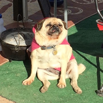
Lucy, the toothless pug, basking in the morning sun at our Colorado River backwaters campsite. She survived that February 2012 night in the desert by hiding under a neighbor’s porch.

And then the day before we were supposed to leave — the day we should have been packing — he let our dog and my friend Janet’s dog out and later let our dog in without remarking on the absence of the little toothless pug. It was hours before I realized that she was gone, lost in the desert. After spending the entire day looking for her and feeling nearly as heartbroken as Janet about her loss, I snapped. I told him I’d had enough of him and cancelled the trip. The next day, I went down to Phoenix to work on a book in the office I’d ironically moved there to be closer to him.

I cooled down after a week or two and agreed to go with him to a marriage counsellor. And although I thought things were on the mend and looked forward to him starting yet another job that would give him more free time, he apparently had other ideas. When I left in May for my summer job in Washington, he signed up at Chemistry.com. A month later, he was sleeping with the desperate old whore who convinced him to dump me — after a 29-year relationship — and go after my money. He even told the judge at the first hearing that I had abandoned him. (WTF?) You can read about the rest elsewhere in this blog.

Anyway, that’s the back story. I’ve been wanting to visit Death Valley for the spring wildflowers for at least four years. This year, I finally got a chance to make that happen.

(Funny how much I can make happen without a sad sack old man holding me back.)

The Drive

It wasn’t an uneventful drive.

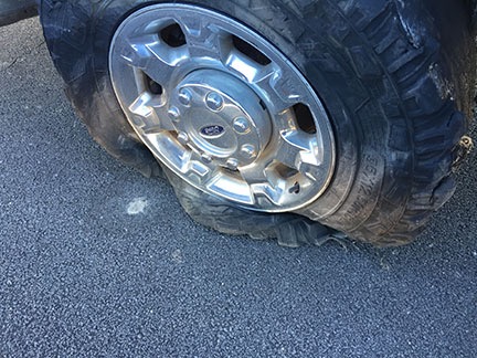
I left Valley of Fire around 10:30 AM and got on I-15, heading southwest. I was just settling in for the three-hour drive with the cruise control locked in at the highway speed of 65 MPH when I felt a weird vibration in the truck. I got into the right lane and killed the cruise control about the same time the right rear tire on the truck blew.

I’d always wondered what it felt like to have blowout at highway speed when towing a 15,000 pound trailer. Now I know.

Flat Tire
Ouch.

I kept control of the truck and managed to bring it to a stop within about 1,000 feet on the narrow shoulder of a very long overpass. Because highway traffic was just three feet away from my door, I lifted the center console and slid across the seat to get out on the shoulder side. The tread on the tire was nearly completely gone. Moving forward to get off the overpass was not an option unless I didn’t mind destroying the rim. The tire would have to be changed right where I was.

For the second time in less than two months, I called AAA.

Mud Flap and Tire
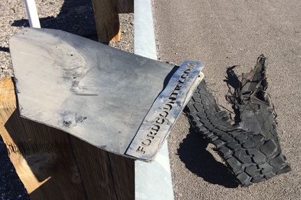
My damaged mud flap, sitting up on the guardrail with a big hunk of tire tread on the shoulder beside it.

While I waited, I walked back along the highway. I recovered a big chunk of the tire, but more importantly, I also recovered the mudflap that had been torn off when the tire blew. I brought them back to the truck and threw the mudflap into the bed.

A flatbed tow truck arrived an hour later. A guy came out and set about lifting my truck’s rear end with a hydraulic jack and lowering the spare tire fastened under the truck bed. In just a few minutes, the tire was changed. Of course, the spare’s pressure was low, but that wasn’t a problem. The truck had a compressor and the tire was soon inflated and I was ready to go.

Honestly, anyone who travels — especially alone — really should have roadside assistance like AAA. This was the second time it helped me on this trip. And yes, I probably could have changed the tire. But it likely would have taken me hours to do it and the tire pressure still would have been low. I got the job done without getting dirty for the cost of a $20 tip.

While I’d been waiting, I’d been working the phones. I called Discount Tire in northwest Las Vegas — a location that was along my route to Death Valley — and arranged for a set of replacement tires. In all honesty, I never did like the off-road tires that had come with the truck. I just hoped I’d get a year out of them. I obviously wasn’t going to. Best to just replace them all now with an all-terrain tire that was better able to handle the weight I was towing. I wound up with a set of four Toyo Open Country tires. Even with a $100 rebate, it was quite a chunk of change. With luck, however, I won’t have to replace them for at least 5 years.

So my next stop was the Discount Tire location I’d called. There was a long line inside. I was told it might be two hours. I secured my place in line, paid for the tires, and then pulled my rig into an empty lot next door. I disconnected the Mobile Mansion, topped off the truck’s tank with diesel, and parked it back in the lot. Then Penny and I went into the RV and had lunch.

That’s one of the nice things about traveling with a house. The fridge and bathroom are always handy.

It was about 3:30 PM by the time the new tires were on and I’d hooked up the Mobile Mansion again. Sunset was two hours away and it didn’t look as if I’d get to Furnace Creek by then. But I put the pedal to the metal and drove. I got on Route 95 and followed that to Amargosa Valley. Then south on route 373 to Death Valley Junction. Finally 190 west to Furnace Creek. There wasn’t much traffic at all and I was able to do (at least) the speed limit all the way. The new tires felt great — and were amazingly quiet compared to the old ones.

Route to Death Valley
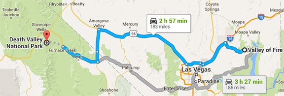
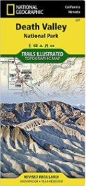
I took the highlighted (blue) route from Valley of Fire to Death Valley.

On the descent down to the valley, the sky to the west, which was full of high, light clouds, turned brilliant pink and orange and then violet. It was probably the best sunset of the trip.

It was nearly dark when I pulled to the curb across from the office for Furnace Creek lodging. I checked in for the campsite I’d have for the next two nights. Then I walked back to the truck and drove it the final half mile to the campground. It was a back-in site between a giant luxury motorhome and some tent campers. I’d never parked the Mobile Mansion at night, but it wasn’t as if I could wait until morning. I set out a lantern on the driver’s side at the back of the site and a flashlight on the driver’s side in the front. And then, with a little guidance from the tent campers, I backed it in.

Got it on the first try. Sometimes I really surprise myself.

Setting up camp was easy because the site was level and there were no hookups. I disconnected the Mobile Mansion from the truck and put out the slides. Done.

The only drawback: that luxury motorhome had a generator running and it was loud. (What is it with these people?) Fortunately, they shut it off at 7 PM sharp.

Dawn at the Dunes

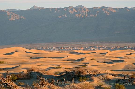
Although I’d hoped to get some exploring in on the afternoon when I arrived, arriving in the dark made that impossible. So I started my explorations early the next morning after a quick breakfast. Penny and I climbed aboard the truck before dawn and headed north toward Stovepipe Wells. I had the idea of photographing the dunes near there around sunrise. Unfortunately, so did a bunch of other people. When I arrived, the parking lot was half full and there were people all over the dunes. Getting a shot without a bunch of footprints or a tourist in it was not likely.

So I backtracked down the road and parked on the shoulder. I climbed into the back of the truck with my tripod and camera and framed a few shots using my 85-300 telephoto zoom lens. The focal length compressed the perspective, as I suspected it would, bringing the distant mountain tops closer. I got a few shots I liked before climbing back into the truck to continue on my way.

Death Valley Dunes
Not long after sunrise along the road between Furnace Creek and Stovepipe Wells in Death Valley.

On the Road to Skidoo

Death Valley Map
I highly recommend this map, which is available from Amazon.

And here’s where I made my mistake. Back in January, I’d had lunch with my friend Rebecca, who had been to Death Valley earlier in the year. She’s showed me some locations on a National Geographic map that I bought and had shipped out to me when I was staying at the Colorado River backwaters south of Ehrenberg. I’d studied the map and had decided to try finding a set of dunes to the west of Ubehebe Crater in the north part of the park. But I guess I hadn’t “studied” the map enough — for some reason, I thought the road through Stovepipe Wells was the right road. It wasn’t until I was at Emigrant Campground that realized something wasn’t quite right and pulled over to check where I was going. I’d gone about 40 miles the wrong way.

Pro tip: Maps can only help you when you use them. Duh. (I should have grabbed one of these maps at the Visitor Center. It’s not as detailed as what I had, but it’s easier to manage in the truck.)

So I came up with a Plan B: explore the west side of the park up Emigrant Canyon Road. The map showed two interesting townsites: Skidoo and Harrisburg. I like wandering around ghost towns and figured I’d check them out.

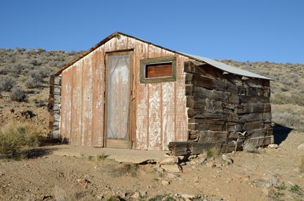
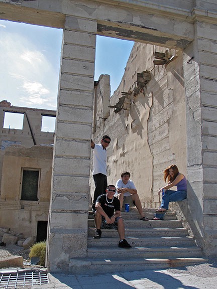
I headed south on Emigrant Canyon Road, climbing ever higher into the mountains on the west side of the park. Outside, the air was cooler — in the low 40s, according to the truck’s outside air temperature gauge. But it was clear and I knew it would warm up. I found the sign to Skidoo and turned left onto a nicely maintained gravel road. Ahead of me, in the near distance, were two white SUVs and a white pickup truck. Soon, I caught up with them and was driving in their dust. When I saw an old cabin on a short road off to my left, I turned and used it as an excuse to let some miles get between us.

Abandoned Shack
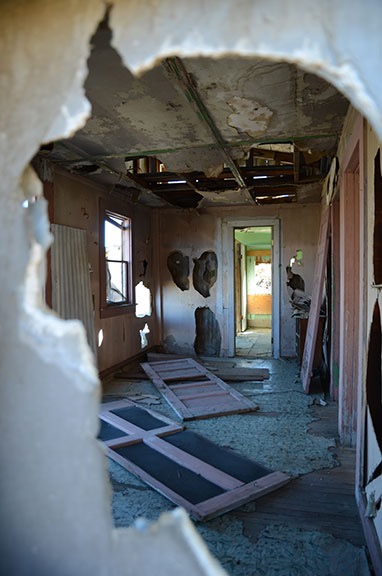
One of the neatest abandoned buildings I’ve ever come upon.

The cabin wasn’t anything interesting other than the fact that it was in remarkably good condition and would still make a very usable shelter. That in itself was remarkable: most unused buildings in this country — especially those in remote places — are targets for vandals who destroy for the pure satisfaction of destruction. There were no signs to keep out so I did what any explorer would do: I opened the screen door and wooden door inside it for a peek. I found an old spring bed frame and some litter inside. No smashed beer bottles, no graffiti, no vandal debris. I carefully closed both doors up the way I found them.

Door Light
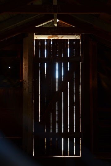
I don’t know why, but I like this image.

In general, the place wasn’t very photogenic. The most interesting shot I got was through a hole in the boards covering the back window: the light shining through cracks on the door. It was the cleanest abandoned building I’d every seen. I hope it stays that way forever.

Mine Shaft and Truck
Yes, I do realize that I probably looked pretty silly driving around Death Valley with two kayaks on my roof.

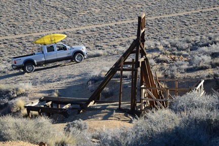
Penny and I got back into the truck and crossed the road. Soon we were climbing up a hill to an old mine site on the opposite hillside from the cabin. I left Penny in the truck — I don’t like to worry about her falling into mine shafts — and explored on my own. There wasn’t much there that I hadn’t already seen before at countless mine sites in Arizona and Nevada: the support structure beside the main shaft, several smaller horizontal mine shafts going into the hillside, and the remnants of old buildings. The site was neat and clean. Thinking back on this, I have to wonder if the park service or volunteers clean these places up. Or if vandals simply avoid National Parks.

We got back on the road and continued the drive to Skidoo. In most places, the road was wide with gentle curves and a bit of washboarding. In other places it was narrow and rocky as it wound along the edge of a steep drop-off. I passed the ruins of another building on my left and decided to explore it on the way back. I was eager to see Skidoo and wanted to be there before the sun had risen much farther.

Skidoo Sign
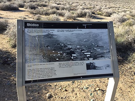
Here’s the sign that tells you you’ve arrived at Skidoo. At the top is a quote: “Here the golden goddess is again singing her siren song of enchantment and California is again beckoning the world with a finger of gold: the world is listening, and coming — TO SKIDOO!” Apparently, the Rhyolite Herald was pretty good at dishing out bullshit back in 1907. All I could think about was where did they get their water?

When I got there, I didn’t even know I was there. It was just a flat area among the hills with lots of dirt roads going off into different directions. I drove up to an interpretive sign set alongside a turnoff in the road that announced I’d reached my destination. Wikipedia calls Skidoo a “virtual ghost town” but I don’t see any “virtual” or “town” about it. There’s really nothing of the town left other than foundation rubble and broken glass.

I’ve been doing some video journalling lately and apparently made one from the top of the hill. I didn’t turn toward the sun, probably because I knew the video in that direction would be crappy. I sound nasal because I was fighting a cold and I’m not sure if the snowcapped mountains are the Sierras.

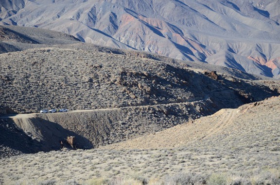
I saw a road going up a steep hillside and decided to check it out. It would be a good test of my new tires. I drove over to the bottom of the hill, popped the truck into 4WD and started a steep climb. There was plenty of room at the top to park and (fortunately) to turn around. So I parked, shut the engine, and climbed out with Penny for a good look. From my vantage point, I could clearly see where the town had been (despite there being no real traces of it), as well as several mine shafts with towers. The two SUVs and pickup truck I’d seen earlier in the day were parked by one of the mines far below me. Off to the northwest, I could see snowcapped peaks.

At Skidoo
I could see the white trucks and the men who had been in them near a mine site across the ravine from my observation point. A photo shot with my 300 mm lens revealed the Noreas logos on the SUVs. One of the men was dressed as a ranger and had likely come in the unmarked pickup with the big antenna on the roof.

Mine Site with Truck
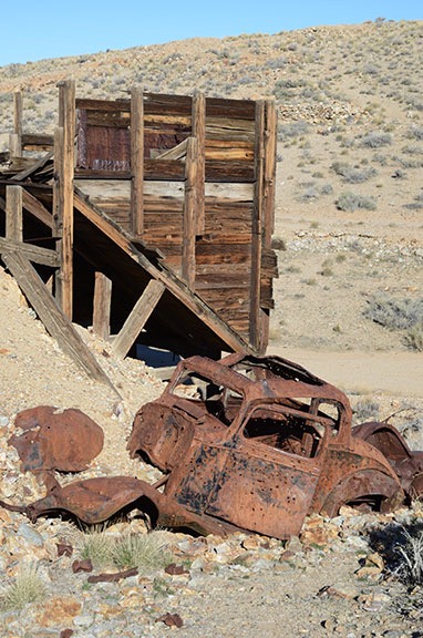
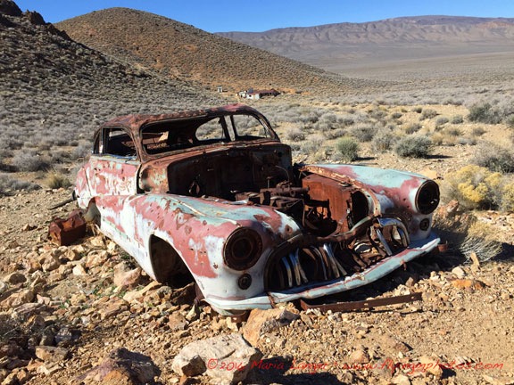
There wasn’t much left of the truck and what was left was half-buried in mine tailings.

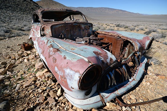
I turned the truck around and headed back, realizing that the road looked a lot steeper from the top than it had from the bottom. I took it slow in 4WD low gear. Then I found my way to another mine site I’d seen from the top of that hill, parked off the road, and got out for a look, again leaving Penny in the truck. What interested me most about this site was the wrecked truck there. For some reason, I like to photograph abandoned vehicles so I really spent quite a bit of time on this one.

Rusty Car Door Wood Planks
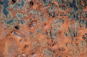
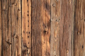
I like the textures you can find among old, ruined things: a rusty car door, a wall made out of wood planks.

By then I was pretty sick of Skidoo and ready to skiddoo. (Sorry, but I couldn’t resist that one.) I turned the truck around again and retraced my route back to pavement eight miles away. I did stop along the way to visit that other abandoned building, but there wasn’t much there of interest so I didn’t stay long. Not even worth sharing a photo of it.

Harrisburg / Aguereberry Camp

Back at Emigrant Canyon Road, I had to make a decision: go back into Death Valley and explore elsewhere or continue on my way. I decided to go a little farther down the road to see if anything else was interesting. That’s how I wound up taking the turn to see the ghost town of Harrisburg, which was partially visible from the paved road.

I drove about a mile or two down the unpaved Aguereberry Point Road and parked with two other vehicles in a tiny parking area in front of a closed gate. The folks from the other vehicles were just leaving their cars and walking toward the ruins about a quarter mile away. They had a dog with them, too, so Penny and I hung back to give them space. I’d later discover that they were part of a group of three, two of which were in period costumes for a photo shoot. We were the only people there.

Through the Wall
A look through the wall of Pete Aguereberry’s old house.

Although maps identify this spot as Harrisburg, a sign at the ruins called it Aguereberry Camp. The main site consisted of three buildings, an outhouse, and the remains of a mine. Farther up the road I’d walked was the ruins of an old Roadmaster sedan and still farther were the ruins of the Eureka Mine, which I did not visit. (There are only so many mine shafts a person can see in a day.) While the photo shoot folks were working around the car, I explored the buildings. They were in disrepair and vandalized, just as I’d come to expect of ruins, but not nearly as bad as I’d seen at other vandalized sites.

From there, Penny and I hiked another 1/8 mile or so to the old car, passing the photo shoot folks on their way back. The car made a remarkably interesting subject for photography — at least in my mind. The original color, teal (?), could still be seen among the rusty patches. Even the logo of the car was visible in one spot — which is how I knew it was a Roadmaster. I took quite a few shots, many of which featured Aguereberry Camp’s buildings in the background. I even got to play a bit with my 10-24 mm lens, which I seldom use these days.

Roadmaster
A wide angle (16 mm or 24mm full frame) shot of the car with Aguereberry Camp in the background.

Wide Angle Car
A very wide angle (10 mm or 15 mm full frame) shot of the car with the buildings visible through the windshield.

We walked back to the building a while later and spent some time chatting with the photo shoot folks. The two models — a man and a woman — had changed back into regular clothes. They were all sitting in the shade, snacking on peanut butter and apples and other tasty treats. They offered me some, but I declined. We talked about Death Valley and photography and they urged me to continue up Aguereberry Point road to the point. “The view is amazing,” the photographer assured me.

Aguereberry Point

Although I felt as if I’d had enough driving along bumpy back roads for the day, I’m not one to pass up a view — especially one that isn’t crowded with tourists. So when I left the photo shoot folks, I continued along the road.

Aguereberry Point was only about six miles from pavement, but much of the road was very narrow for most of the way. There was a section that it wound through a narrow canyon that I could imagine being treacherous in a rainstorm. Then it came out onto a hillside and continued climbing out in the open. Up and up and up, finally ending in a small parking lot that looked as if it were at the top of the world. Penny and I were the only ones there.

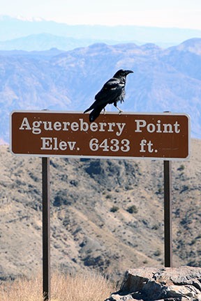
The view was good from the parking lot, but the photographer had advised me to take the trail to the point. After walking (and climbing) a bit on the wrong trail, I got on the right one and followed it as far as I could go. The view of Death Valley was unobstructed to the northeast and southeast, with a mountain due east that blocked the view that way. At an elevation of 6,433 feet, we were at least that high above the valley floor, much of which is below sea level. It was dead quiet.

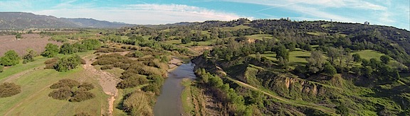
Photos really can’t convey the full picture of what this place is like, but here’s a panoramic image to give you an idea. Was it worth the drive? Hell yes.

Aguereberry Point Panorama
Here’s a panorama taken at the point. Click the image for a larger version that you can scroll to see details.

Raven
Ravens like dog food. Who knew?

I walked back to the car and put out some food and water for Penny. A young couple drove up and parked next to the truck. As they donned backpacks, we chatted about places to visit in the park. I had nothing to offer except a recommendation to skip the drive to Skidoo. They told me that the wildflowers were amazing down near Ashford Canyon, where they’d camped overnight. Then they were off down the trail, leaving me to chase off the ravens that were eating Penny’s food.

On the Trail of Wildflowers


This video was released by the park service less than a week before my visit. Watch it full-screen.

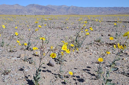
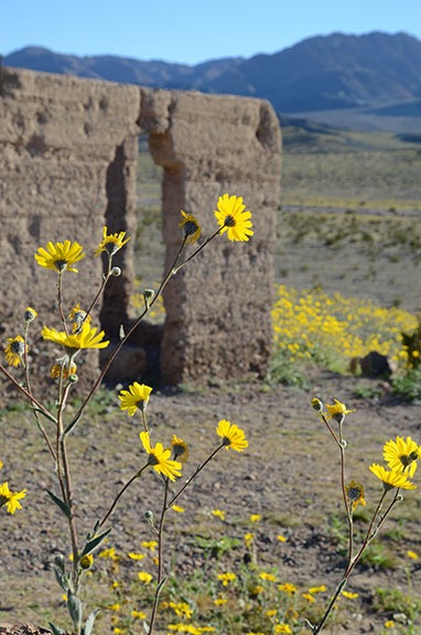
From there, I retraced our route back to pavement and, from there, back down into Death Valley. We passed through Stovepipe Wells and headed toward Furnace Creek. That’s when I noticed the wildflowers I’d missed that morning on my predawn drive. The roadsides were full of them. I didn’t realize it, but Death Valley was heading for a once-a-decade “super bloom.”

Flowers
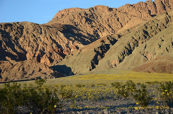
I thought there were a lot of flowers here, north of Furnace Creek. But this was nothing compared to what was about 50 miles down the road.

After a brief stop to check out the desert pupfish at Salt Creek, I continued past Furnace Creek on Badwater Road. I was back among the tourist crowd, with lots of cars and buses along the way, especially at Badwater, which is the lowest point in the U.S. at 282 feet below sea level. There were lots of people walking out on the salt flats there, but I didn’t bother to stop. I was aiming for Ashford Canyon, where the young backpackers had said there were so many flowers. The further south I got, however, the more flowers there were. People were parked alongside the road where the flowers were thickest, taking photos and walking among the bright yellow blooms. I couldn’t resist a few stops myself, although I knew I’d get better shots when the sun was lower in the sky.

Death Valley Flowers
The light wasn’t as good as it could have been, but I couldn’t resist stopping for a few photos along the way to Ashford Canyon.

I was also surprised to see standing water in various places alongside the road. I’d heard that there had been a lot of rain in Death Valley that fall, but I’d assumed the water had run off or seeped into the ground. Instead, there were a few dry lake beds that weren’t exactly dry. Some were almost swampy. Although I hoped for an opportunity to get some good reflection shots, conditions were unfavorable; a breeze put just enough ripples on the water surface to break up any good reflections.

Flowers at Ashford Mills
Desert gold wildflowers at Ashford Mills.

I arrived at the remains of Ashford Mills after 4:30 PM. The same big yellow flowers — appropriately named “desert gold” — I’d been seeing along the way were scattered all around the ruins. I wandered around the ruins and took photos while Penny sniffed here and there. It was amazing to see hills in the distance yellow with blooms.

Death Valley Flowers

Death Valley Flowers

Death Valley Flowers

Death Valley Flowers

Death Valley Flowers
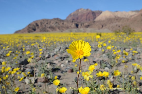
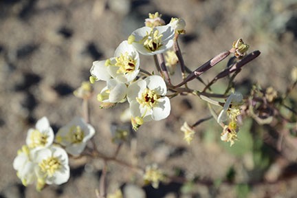
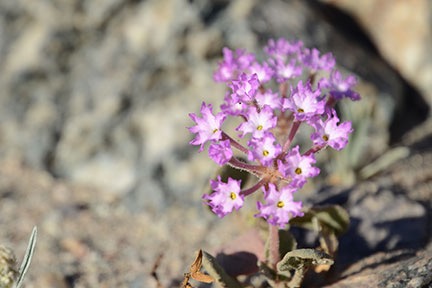
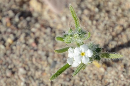
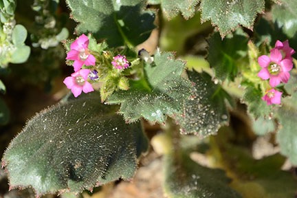
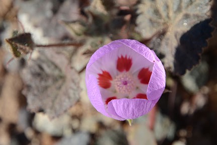
Here are several close-up shots of some of the smaller flowers I spotted while wandering around.

There were also some smaller flowers that were less obvious and required careful attention to spot. I did a lot of crawling around with my 16-85 mm lens — I don’t have a macro lens — to get close-up images of them. The group of four people sitting out at a picnic table near the parking lot, eating a late lunch or early dinner, must have thought I was nuts. I was really getting into it.

The turn for Ashford Canyon was right across the road from the road to Ashford Mills. It was a narrow two-track road that wound up a hillside and then into the canyon. The young backpackers had said the flowers were good up there, but as I began the slow bumpy drive I began wondering whether they meant that the flowers were good in that general area. They certainly were amazing. I drove for about a mile when I realized it wasn’t going to get any better than what I was already seeing. I found a place to turn around and started back.

By this time, the sun was sinking quite low. Mountains on the west side of the park would make sunset a lot earlier than I expected after consulting Siri that morning. (Ask Siri what time sunrise or sunset is and she’ll tell you and provide a weather report.) I wanted to head back for a late afternoon shot of a particularly flower-filled area along the road. So I headed back toward Badwater and Furnace Creek. I reached the location I was thinking of just as the light was getting very good and got out to take a few photos.

Death Valley Flowers
The carpet of yellow flowers is a stark contrast to the bare rock walls on either side of Death Valley.

Leaving the Valley

By the time I was ready to go back, the hillsides were in shadow. It was dusk when I pulled up to the Mobile Mansion.

If you’re wondering why I bothered to give you the backstory at the beginning of this post it’s because of this: While I drove and hiked around and explored and photographed Death Valley with my dog, I spent a lot of time thinking of what the trip might have been like four years earlier with the man I thought was my life partner. With five days to spend in the park, we would have seen a lot more. But would the trip together have gone as smoothly as I’d hoped? Or would he have been stressing about his mother left behind? And would the trip have been a repeat of all those amazing road trips we’d taken together in the 1980s and 1990s? Or would we have bickered over every little thing we did?

I know now, in my heart, that our relationship was like the walking dead — existing with no life, no future. In February of 2012, I wanted to go back to the way things were when our relationship was good and strong, when we were two people of one mind who shared ideas and dreams. But he had already given up and was just biding his time, waiting for his escape. I loved and trusted him too much to see the truth about what he’d become: a bitter old man, blaming me for his failures in life, eager to take revenge on imagined offenses.

Although my trip had been short — too short, I think! — it had been taken on my terms, without pressure or a need to compromise. I’ve been traveling alone since long before my 19-day “midlife crisis road trip” back in 2005. While it’s nice to travel with a companion, good travel companions are hard to come by. I lost mine years ago, many years before my divorce. While I’m sad that he’s gone, there’s no denying how much better off I am without him.

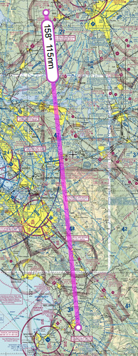
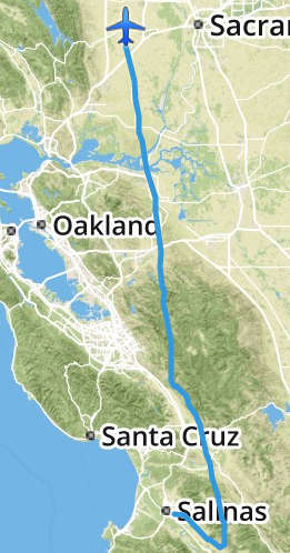
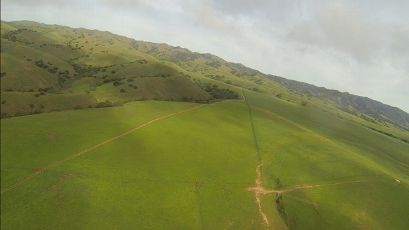
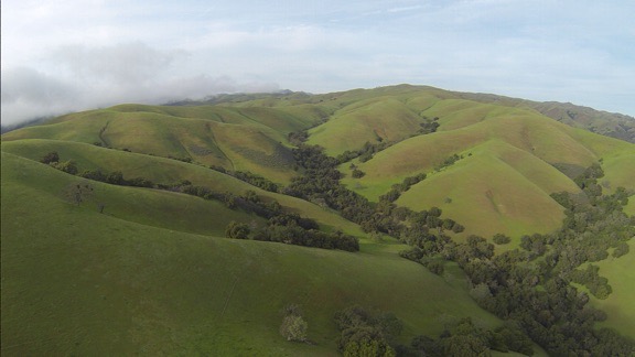
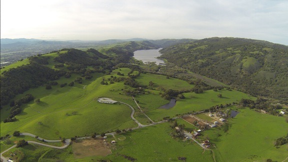
Although I’d considered doing a little early morning photography the next day, I realized that the locations I wanted to visit were too far away to get there and back and still leave the park by 10 AM. It would be better to come back another time, when I had more time to spend. My next stop was in the Sacramento area of California, where I’d be based with the helicopter for a frost contract. It was a six-hour drive and I looked forward to seeing a few friends when I arrived. Wednesday would be my travel day and Thursday would be a day to kick back and relax before taking Alaska Air home to fetch the helicopter.

To minimize the noise I’d make on departure the next morning — keeping in mind that my tent-dwelling neighbors would hear every sound I made — I decided to hook up the Mobile Mansion that evening. So I cranked down the landing gear, backed the truck into place, and lowered the front end of the Mobile Mansion onto the hitch. Within a few minutes, the chains and power plug were in place and the landing gear was up and locked. All I had to do in the morning when I was ready to go was to close up the slides.

I had a nice salad for dinner. I tried hard to ignore the sound of the generator next door. I don’t understand how I can camp day after day in my rig without running a generator when these people in their fancy motorhomes can’t seem to spend any time in theirs without their generator running full-time. Fortunately, they turned it off at 7 PM sharp.

After dinner and a quick clean up, I relaxed in bed with a book. Penny curled up in her bed beside me. I was dead asleep by 9 PM.

In the morning, we were on the road by 7 AM, heading west on the road past Stovepipe Wells toward Panamint Springs. That drive didn’t go anywhere near as planned — but that’s another story.

A Flight to Salinas

Any excuse to fly, eh?

I’m currently based in the Sacramento area of California for my late winter/early spring job as a frost control pilot. I live part-time in a nice farm town I’ve grown to know and like over the past four years, waiting for the weather to turn cold and a phone call telling me to get ready to fly. At that point, “passive standby,” when I get paid by the day to have my helicopter on-site, turns into “active standby,” when I get paid by the hour to wait. When the fly call comes, I theoretically spring into action, firing up the helicopter and heading out over my almond orchards to circulate air and keep the frost from damaging the developing nuts.

I say “theoretically” because although this is my fourth year as a frost pilot, that fly call has never come. Instead, each season I wind up being paid by the flight to fly to California, being paid by the day to hang around in very pleasant weather doing whatever I like while it’s still kind of dreary at home, occasionally being paid by the hour to sit in my truck at the airport at night waiting for a fly call, and eventually being paid by the flight to fly the helicopter home. I earn enough in two months to carry me financially until cherry season starts in May — and beyond. Along the way, I have a grand old time in Northern California’s Central Valley. I’ve made some friends, done a ton of hiking, gone wine tasting, kayaked the American River and Lake Solano, learned to fly a gyro, gone ballooning, and even given my bees an early start to the spring season. In general, it’s just an extension of my winter travels, with lots of flexibility to go where I like and do what I want — as long as I can get back to base by midnight when I’m put on active standby.

Anyway, my point is that I don’t have a lot of flying to do for this job. So instead, I take the helicopter out on “maintenance flights.” This is where I start up the helicopter to make sure it’ll start when I need it and since I’ve got the engine running, I may as well take off and since I’m taking off, I may as well go somewhere interesting like up Cache Creek or into Napa Valley or around Sutter Butte.

Cache Creek 2
My favorite “maintenance flight”? Low-level up Cache Creek, especially just after dawn.

Yesterday’s Excuse for Flying

My helicopter is coming up for overhaul soon and I’ve begun interviewing service centers to find one that’ll do the job the way I want it done at a price I’m willing to pay. I’ve already visited a shop in St. Augustine, FL, and have talked to the folks in Hillsboro, OR, who sold me my helicopter nearly twelve years ago. (Hard to believe it’s been that long, eh?) I’ve recently gotten more motivated to learn my overhaul options; one of the magazines I write for has agreed to a 1000-word article about my search for a shop. So I obviously need to visit more shops.

So the other day, I checked the Dealer/Service Center page on Robinson Helicopter’s Website. And I made a list of the centers in Northern California. And I started making calls. By the end of the day, I’d made plans to visit the folks at Airmotive Specialties, the service center in Salinas.

DWA to SNS
The direct route to Salinas was easy enough.

I was not interested in driving to Salinas. The 170-mile drive would take at least 3 hours each way. Obviously, I’d fly. Foreflight told me it would take about an hour and 20 minutes and that was fine with me. (I have 200 hour to burn off on the helicopter before November.) A review of the direct route showed that it was pretty easy, with no serious concerns about airspace or mountain terrain. Weather was forecasted to be good on Wednesday, although rain was moving in north and east of San Francisco (where I’m based) later in the week. It was a no-brainer. I made tentative plans to fly on Wednesday afternoon.

The Flight Down

I spent Wednesday morning taking care of odds and ends: writing a blog post, updating a friend’s website, answering email messages, scanning receipts, walking to the closest RedBox to drop off a video and pick up another one. The man I needed to meet at Airmotive would be at the office all day, so there was no rush. I had lunch just after noon, then climbed into the truck with Penny and headed out to the airport. A while later, after setting up my GoPro “nosecam,” iPad with Foreflight, and phone for music, I fired up the engine. I was heading south by 1:30 PM with Penny lounging on her bed in the front passenger seat beside me.

It was an uneventful flight. Well, mostly.

Why I Tend to Avoid Towered Airspace

I think a sidebar is in order to explain why I didn’t fly right through Livermore’s airspace and talk to the tower.

First of all, my direct route would have put me less than 1/2 mile into Livermore’s airspace — nowhere near the runway or tower. It wasn’t a big deal to adjust course a tiny bit to the left (east) to avoid it.

Second, my experience with towered airports has been a real mixed bag over the 15+ years I’ve been flying. If an airspace is directly on my flight path, I’ll ask the controller to transition. I might make a request like “Helicopter six-three-zero-mike-lima, 10 miles northeast, would like to transition southbound on the east side of your airspace.” (That’s what I might have said on Wednesday to Livermore.)

About half the time, the tower will allow me to “proceed as requested,” sometimes asking me to “ident” (push a button on my transponder which momentarily makes me more visible on his radar) or even assigning me a squawk code (an unique 4-digit code for my aircraft on radar). All that’s quite reasonable and fine with me.

But other times, the tower will require me to follow a certain route through the airspace — for example, over the top of the airport, midfield at a specified altitude. This can waste time and fuel. And still other times, the tower will instruct me to climb to an altitude above the airspace — usually 2500 feet AGL or higher — to “transition.” (Technically, this is not transitioning the airspace because I’m technically not in it when I’m flying that high over it.) This is nosebleed territory for helicopter pilots who typically fly 500-1000 feet AGL, not to mention a real waste of time and fuel. And other times — admittedly rarely — the tower will simply deny the request and tell me to stay clear. (Scottsdale liked to do this.)

So the solution I’ve come up with is this: if my direct route doesn’t take me within two miles of the runways or tower, I adjust my path to fly around the airspace and monitor the tower frequency to listen for traffic. At my altitude, airplane traffic — other than crop-dusters — is seldom an issue.

There was a close call with a biplane crop duster who apparently didn’t see me where I was cruising at about 1000 feet AGL (Above Ground Level) just to avoid crop-dusters. I guess he was going back to base. I dumped the collective and dropped down to about 300 AGL quickly while taking other evasive actions. He passed above and behind me and I continued on my way, climbing back up to at least 700 AGL and keeping a sharp eye out for others.

And then near Livermore, another traffic situation. I’d tuned into Livermore’s tower to monitor the frequency as I flew southbound just east of the tower-controlled airspace. I heard the controller warn another pilot about traffic that sounded just like me. I stayed quiet until the controller came back on the radio about a minute later, sounding a bit alarmed that the traffic (me) was only a half-mile away. I looked up and left and saw the Cessna flying at least 500 feet above me, westbound. I keyed the mic button and said: “Livermore Tower, helicopter six-three-zero-mike-lima, just east of your airspace, has that airplane traffic in sight. I’m passing below him, no factor.” The controller sounded more than a little relieved when he responded with thanks.

Marine Layer Moving In
You can see the marine layer moving in on the right side of this shot. I was about 5 miles from Salinas Airport here.

I was in the mountains, abeam San Jose Airport, when I started noticing the marine layer moving in from the west. I fiddled with Foreflight’s settings to get visibility information for the nearby airports. All of the ones in my vicinity — including Watsonville and Salinas up ahead — were reporting 10 miles or more. But I didn’t like the way those low clouds look. I know from experience that the marine layer can turn an airport from VFR to IFR in fifteen minutes when it’s moving just right.

I landed at Salinas and followed the controller’s directions to “the biggest hangar on the field.” I parked in an empty airplane tie-down spot nearby. As I shut down, I looked at the windsock and the low clouds. The wind was clearly pushing the marine layer in from the west. I might not have much time if I wanted to get back that day.

At Salinas

My meeting went extraordinarily well. I met the boss, had a quick tour of their facility, and chatted with him about my options. He and his crew have done more than a few Robinson overhauls, including one for a helicopter that was parked right outside his hangar door. He’d learned a few things that would save me money while keeping me safe and in full compliance with FAA requirements. He had local sources for aircraft painting, upholstery, and parts inspections. Best of all, he could get the work done within my stated time restraints — I would need it back by mid February for next year’s frost season.

He and his helicopter guy came out and looked at my ship. They said it looked good — I have to wonder if they say that to everyone or if so many other ships don’t look good that they feel compelled to say something when they see one that looks better than usual. I have to agree that it doesn’t look 11+ years old. I’ve taken very good care of it over the years, getting quality maintenance done by good shops and keeping it in a hangar (or garage) for most of its life.

My visit ended by giving him my complete contact information so he could work up a quote. I’d have to order the overhaul “kit” from Robinson at least six months in advance to get it in time. Clearly, I’d need to choose a shop a lot sooner than I expected to, possibly as early as May 1.

By the time I got outside, it was overcast and downright cold. The marine layer had indeed moved in, with clouds just 1200 feet above the field (according to the ATIS recording) and mountain obscuration to the north, where I needed to go. It looked as if the only clear routes were to the south. I’d need to fly around the weather to move north.

But first I needed fuel. I’d burned half of what was on board on my trip down and did not want to go into any weather situation without full tanks. A call on the unicom frequency got me nowhere, so I walked over to the general aviation terminal and found someone in the Airport Manager’s office who gave me a phone number to call for fuel. While I waited for the truck, I fiddled with Foreflight to get additional weather information. But I didn’t need a computer or weather report to see that I wasn’t going to be taking the direct route back.

Around this time, I realized that I’d forgotten to text a Facebook friend who worked at the airport. She’s a medevac pilot who was on duty that evening. I was supposed to text her when I arrived so she could drop by. But the incoming marine layer had distracted me and I’d forgotten. Now, with the weather getting worse by the minute, I couldn’t wait around. I texted her my apologies. Another time? Chances are, I’d be back in November; I’d very much liked what I’d seen and heard at Airmotive.

The Flight Back

SNS to DWA
My actual track, as logged by Foreflight, on my return flight from Salinas. Talk about circumventing weather!

Once the fuel was on board and I’d added some oil, I climbed back on board and started up. The ATIS mentioned ILS approaches but the airport was still VFR. I asked for a departure to the east, got clearance, and took off.

I had my GoPro “nosecam” running for the whole flight. With the sun behind me — if it made an appearance — I knew the light would be much better than it had been on the way down. (I don’t record every minute of every flight. I already have too much mediocre footage; now I just try to get good footage.) The camera captured the situation well: very low clouds for quite a distance. I aimed for some brightness on the horizon, stayed at an altitude that kept me below the cloud layer, kept a sharp eye out for towers, and flew southeast.

Marine Layer
I really wanted to steer left in this shot, taken less than a mile from the airport. But instead I aimed for that bright spot in the far right — southeast bound.

Don’t get me wrong. I could have tried scud running a path up the valley to the north. And I might have found a comfortable way to get where I wanted to go. But I’ve run scud enough times and have found my way blocked enough times that I’ve learned not to even bother trying if there’s an easy way around it. I know marine layers well enough to know that they don’t usually cross mountains. If I could get to the far side of the mountains east of the airport, I’d find a clear way north.

And that’s exactly what happened. I aimed for the brightness, which got bigger and brighter the farther I went. Suddenly, I was in sunlight, climbing the bright green foothills of the mountains on a northeast heading. Soon I was at cloud level just to the east of the clouds heading due north. Before long, I was above the marine layer, looking out at islands of mountaintops in the clouds to the west.

Out of the Marine Layer
Only six minutes passed from the time the previous photo was snapped to the time this one was snapped. At this point, I was banking to the northeast, climbing above the marine layer just east of where it got “stuck” in the mountains.

I adjusted my course on both my helicopter’s Garmin 430 GPS and Foreflight and attempted to fly direct back to my base. The lush green hills were amazingly beautiful and the shadows from the sun shining through the marine layer gave them an extra depth. It was hard not to detour in a few places to get some better views. I let the camera run, figuring I’d get a few good shots along the way.

Green Hills
California’s hillsides are gorgeous in the spring. You can see the marine layer trying — but not succeeding — to climb over the hills on the left.

I flew for a while to the east of the marine layer, but as I crossed the valley near Hollister, the marine layer moved in beneath me. I was already about 2500 feet up, having just crossed some mountains, and knew I’d have to cross more mountains on the other side of the valley, so I stayed at altitude and crossed above them, with glimpses of the farm town beneath me. The air up above the clouds was a bit rough and we got bounced around a bit. So the next time I had the option of flying above or below the marine layer — near Livermore — I elected to fly below it. That had me flying just below the clouds along a hillside east of the airport there, almost on my original flight path down.

Over Hollister
I flew above the marine layer clouds at Hollister and was rewarded with a bumpy ride.

Lake Valley
I couldn’t resist flying down this lake-filled valley east of San Martin.

Lick Observatory
While I didn’t overfly any of the buildings at Lick Observatory, I did fly close enough to get a good look. (Hope I didn’t wake anyone!)

Golf Course
I was over this Livermore area golf course at 4:39 PM when one of my Twitter friends saw me fly by.

The rest of the flight was pretty uneventful. I made a straight line back to my base, over two wind farms, a handful of small cities, the Sacramento River, wetlands, and lots of farmland. It was just after 5 PM when I set down on my grassy parking spot at the airport.

Wind Farm
Windmills that had been still on my way south were turning by the time I flew back north.

Birds
All of the wetlands in northern California are full of these large white birds that take flight as soon as they hear a helicopter approaching. This was a big flock — yes, every white dot here is a bird. Fortunately, they stay very close to the ground.

Final Approach
On final approach to this year’s base of operations west of Sacramento.

I gathered together my things, let Penny out to run on the grass, and locked up the helicopter. I chatted for a while with one of the line guys about the upcoming rainy weather and placed a fuel order. (The helicopter must always be topped off with fuel when I’m on call.) Then Penny and I headed back to the truck and our temporary home.

I’d logged a total of 2.7 hours of flight time.

Later, after I drove back to where I’m staying and relaxed for a while, I checked in with Twitter. I found a tweet from one of my twitter friends who had apparently seen me from the ground while he was golfing in Livermore. How’s that for small world syndrome?

It had been a good flight and a nice day out and about. Although I could have done without the detour — which probably added 20 minutes of flight time to my return trip — I certainly couldn’t complain about the views along the way.

Some Thoughts on Travel

“We travel not to escape life, but for life not to escape us.” – Anonymous

Ludwigsburg
Perhaps my wanderlust was fed by this 1976 trip to Germany with my grandparents. Or perhaps it’s in my DNA, planted by my maternal grandfather, who used to follow us on vacation when I was a kid.

I need to start off by saying that I love to travel. I love getting into a car or plane or train with luggage and going someplace and staying for a while. I love learning about new places, meeting new people, and seeing new things.

Travel for Work

In the past, I was fortunate to have had a series of jobs that sent me all around the country. My job as an internal auditor for ADP (based in New Jersey) sent me to Chicago, Kansas, Los Angeles, Orlando, New Orleans, Denver, and Washington DC, as well as a few places closer to home. Trips ranged from one to three weeks in length. The job was 40-50% travel and I was told I’d get tired of it. But I never did.

When I started out as a freelancer, I worked as a hands-on computer trainer for Data Tech Institute. They sent me on numerous trips all over the eastern half of the country, from Milwaukee to Cape Cod to Atlanta. The trips were three days each: a travel day followed by two work days with travel at the end of the second day. I remember one particularly busy month when I visited eight different cities with 20 airplane legs and a round trip train ride. While I was exhausted at the end of that month, I was also ready for more.

Later, my writing work took me to New York, Boston, San Francisco, Toronto, Vancouver, Santa Barbara, and Boulder to speak at conferences, meet with editors, and record video courses. I looked forward to every single trip.

Even my flying work got me traveling. Short trips to tourist destinations like the Grand Canyon, Sedona, Monument Valley, and Las Vegas. Overnight trips for survey and photo flights in northern Arizona, New Mexico, California, and Nevada. Training flights to the Los Angeles area. Long-term trips to Washington (where I later moved) for cherry drying and to California’s Central Valley for frost control. I loved those trips most — probably because someone was paying me to fly my helicopter there.

I simply loved to travel.

Don’t get me wrong — It isn’t because I didn’t like it at home — I did. (Well, I did until my marriage started falling apart.) I just liked to get out and get a new perspective of the world. And to me, that’s what traveling is all about.

The Stay-At-Home Rut

My future wasband and I traveled quite a bit during the first 20 or so years of our relationship. We had some amazing trips: Seattle to San Francisco by car; Shenandoah Parkway, Skyline Drive, the Blue Ridge Parkway, and the Outer Banks by motorcycle; and a handful of islands in the Caribbean by cruise ship are among the top 10. He even accompanied me on quite a few of my business trips — several times to California and once to Hawaii on my frequent flyer miles — and I went with him on a few of his.

Havasu Falls
I went to Havasu Falls for the first time in 2004 on an Arizona Highways photo excursion. Alone, of course.

But that ended in the mid 2000s when he started a series of dead-end jobs with limited vacation time. Suddenly, long trips were difficult to arrange and weekends were the only time he could get away. (Unless, of course, he needed to visit his mother; he could always make time for her.) I tried to get him to commit to one three-day weekend trip every month. Doesn’t sound like much, does it? But it apparently was.

I fell into in a stay-at-home rut. I wanted to travel — and I did actually make a few trips on my own — but unless it had some connection to my work, it wasn’t easy to do without having to deal with the resultant guilt trip my wasband put me on. You see, it wasn’t fair to leave him behind. Why should I have fun when he couldn’t? So I stayed at home, waiting, eventually looking forward to spring when I could go back to Washington, get a change of scenery, and spend time with friends. By that time, didn’t want to be at home.

Things are different now, of course. I don’t have a ball and chain holding me back. All I have is a 10-12 week period every summer when I’m stuck in the Wenatchee area for cherry drying work and another 8 weeks in early spring when I need to be within a few hours commercial flight time of Sacramento for frost work. I’m pretty much free to travel the rest of the year. Best of all, I don’t have to wait for a weekend to do it.

I got a chance to really stretch my legs in the autumn of 2012 and spring of 2013 with multiple trips from Arizona to California, Las Vegas, Washington, and Florida. I can’t tell you how good it felt to finally be able to go wherever I wanted whenever I wanted.

The Benefit of Traveling Alone

Beatty NV
My self-labeled “midlife crisis road trip” in the summer of 2005 lasted 19 days and covered 10 states. I saw a lot of off-the-beaten-path places, like this ghost town in Nevada.

Although I do prefer traveling with a good travel companion, I’ve only managed to find one — and she lives in Colorado with her own set of responsibilities. I thought I’d found another this past summer, but we apparently had different ideas of what “sharing the cost” meant. If I’m going to pay for more than half a trip, I’ll take it by myself so I don’t have to compromise with a “frugal” — his word, not mine — travel companion.

Compromise is only part of the problem when traveling with a companion. The other is spontaneity — the ability to make last minute plans and see them through. When there are two or more people traveling, planning a spur-of-the-moment trip is nearly impossible. Even making changes to travel plans once you’re on a trip is difficult. But when you’re running the show and you don’t have to worry about making someone else happy, you can do whatever you like, whenever you like.

And that’s where I am today. Loving it.

Recent Trips, Upcoming Plans

Since cherry season ended in late July, I’ve gone on several trips:

All that in three and a half months! It’s amazing I get anything done around here.

And that doesn’t include day trips to Seattle (for shopping), Woodinville (for wine-tasting), or local hiking trails and mushroom-gathering locations.

Right now, I’m thinking about other trips. I’ve already got an overnight trip to Spokane (yeah, big deal) with a friend planned. If I don’t spend the winter in Arizona, I’ll likely go on my annual cross-country skiing trip to Winthrop. One way or another, I’m sure Arizona will be a January destination — I’m thinking of driving down with my boat and stopping at various lakes along the way. Looks like I’ll spend part of the late winter in the Sacramento area again for frost; if that doesn’t pan out, I’ve got a job offer in Ohio that I’ll try to grab. (Yes, I do work for a living.) I’ll be back in Idaho with my boat to visit friends with a new home on the Spokane River and would love another trip to Alaska in May.

What about big trips, like the one I’d hoped to take with my wasband in late 2012 to Australia? Well, those are on the back burner right now while I finish my home and get my helicopter ready for its overhaul next winter. Once that’s all done and the dust has settled, I’ll be thinking about going way south for the winter of 2017/2018.

A travel companion would be nice, although not required. I’m looking for just the right person to join me.