Lake Powell to Monument Valley by Helicopter

Part of my Southwest Circle Helicopter Adventure.

This article was originally written for Aircraft Owner Online magazine. I write their monthly “Adventure Flying” column. I normally pull old blog posts for publication, but this time, I wrote an original piece for them. You can find it in their November 2010 issue.

Although I’m based in the Phoenix, AZ area, I spend an unusual of time at Lake Powell doing aerial photo flights for amateur and professional photographers. In September of this year, I flew a total of 20 hours over the lake with at least 20 different photographers on board. I usually get as far uplake as the San Juan River confluence, which is halfway to Monument Valley. But due to the difficulty and expense of getting aerial photo permits for Monument Valley, I rarely fly there.

The one thing that does get me to Monument Valley is Flying M Air‘s Southwest Circle Helicopter Adventure. That’s a 6-day excursion by helicopter that starts in Phoenix and spends a night at Sedona, Grand Canyon, Lake Powell (at Page), Monument Valley, and Flagstaff before returning to Phoenix. I don’t do this trip often — frankly, it’s quite costly and there aren’t many folks who want to spring for it — but I happened to do one in October 2010. In fact, as I’m typing this on my laptop, I’m looking of the window of my room at Goulding’s Lodge at the first light striking the famous monuments of Monument Valley.

On this particular trip, I rigged up a GoPro Hero camera on my helicopter’s nose. Although I used this “nosecam” to shoot video on the first day of the trip, the mount introduced too much vibration to make the video usable. For the remaining days of the trip, I switched over to still photos. The camera automatically shoots a high resolution image every 5 seconds as I fly. With 720 photos per hour, I usually get a few good shots on each leg of the trip.

Wednesday was one of the most scenic legs of the trip. We flew from Page Airport (PGA) up Lake Powell to the San Juan confluence and then east to the airstrip at Goulding’s Lodge in Monument Valley (UT25). On board with me were my two excursion guests and all of our luggage for the 6-day trip. I pack the luggage on and under the seat behind me and sit my guests in the two right seats (front and back) so they get the same view. I then fly to put the best views on their side of the aircraft.

We lifted off from Page at about 2:30 PM. The ASOS reported wind at about 8 knots out of the north, but it sure didn’t feel that strong. I made my radio call and then departed right across the runway, heading uplake. A Citation jet called a downwind a few moments later; we caught sight of him high above us as we crossed the airport fence.

Departing PGA

Our shadow as we crossed the runway at Page Municipal Airport.

It was a beautiful day, with high, thin clouds tracing lazy lines across a clear blue sky. The October afternoon sun bathed the landscape with a soft light that illuminated the red rock cliffs and buttes, cast shadows in the canyons, and accentuated the blue of the water. Sure, the light was too harsh for the aerial photographers I usually take around there, but for my passengers and me, it was great for taking snapshots of our surroundings.

The first canyon we crossed was Antelope Canyon, which is just east of the airport. Normally, I just buzz across it, but the tour boat was inside the canyon, so I made a turn to the left so my passengers could get a photo of it. I didn’t circle, though. I’m extremely conservative with fuel on the fourth and fifth days of the excursion, since there’s no fuel between Page, Monument Valley, and Flagstaff (or, in this case, Winslow). I need every drop of fuel I have on board to get to my Day 5 destination on Thursday with required reserves on board.

Antelope Canyon

Most people see Antelope Canyon from the inside, where it’s a masterpiece of sandstone swirls carved by wind and water. But this is the view I see most often.

We continued uplake, passing Antelope Point Marina and the mouth of Navajo Canyon. I made a position call a mile north of iconic Tower Butte and changed from the Page airport frequency to the uplake frequency (122.75). I repeated the call on that frequency and got into a discussion with the returning tour pilots. They’d be coming my way at 5,000 feet; I’d stay out of their way by flying at 4,500 feet.

The tour traffic is a major concern for anyone flying at Lake Powell. It’s a very good idea to learn the tour routes, altitudes, and reporting points they use before exploring in your own aircraft. There’s nothing scarier than flying the lake and seeing a plane flying where you don’t expect it, especially if it’s not on frequency or doesn’t know where it is in relation to the usual reporting points. Ten minutes with a tour pilot and a chart at Page Airport is enough to get the basics.

We slipped between Dominguez and Boundary Buttes at the south end of Padre Bay and continued uplake. Winding canyons opened up on our right. I pointed out a cluster of kayaks near a powerboat in a canyon with water as smooth as glass. In the main channel, you could clearly see the wind on the water. Not enough to make whitecaps, but gusty enough to see round patterns of movement appear and disappear across the water surface.

Dominguez Butte

My usual uplake route takes me between Dominguez and Boundary Buttes. In the far left of this photo, you can see Padre Butte, referred to by local pilots as “submarine.” Navajo Mountain looms in the distance.

We passed the south side of Gregory Butte and Last Chance Bay as two tour planes flew by overhead. Last Chance is a long, wide canyon with steep sandstone walls. It’s a long boat ride to the end where there are a few sandy spots suitable for houseboat parking. Distance to parking and the cost of fuel are part of what keeps the canyon free of traffic, even during busy summer months. On this October day, however, the whole lake was quiet; I don’t think we saw more than 20 or 30 boats.

We flew over the main channel of the lake as the canyon narrowed. One of my passengers pointed out Dangling Rope Marina and asked me about it. I told her what I knew: it was a marina only accessible by water. There were no roads in or out. I then told her a story about our stop there 20 years before on a houseboating trip. How I miss cruising the lake in a houseboat!

Lake Powell from the Air

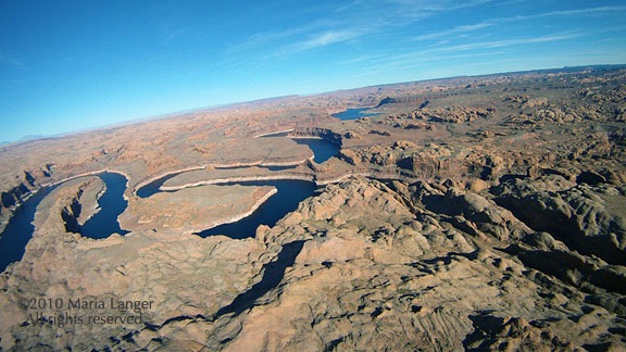
Over the main channel of Lake Powell just uplake from Last Chance Bay. The canyon walls rise about 800-1,000 feet off the water’s surface here.

We were nearing the mouth of the canyon that would take us to Rainbow Bridge. As I flew, I’d been listening to the radio and knew there was a female pilot in the area. I also knew there was another tour plane behind me, on its way to “the bridge.” It’s a tight squeeze in the canyon and my challenge is always to stay as low as possible to ensure my photography clients can get the shots they need. Over the years, I’ve perfected my approach.

The female pilot was just leaving the area when I reached the mouth of the canyon and turned in. I flew up the canyon at 5000 feet, telling my passengers what to look for as we flew: the dock, the trail, the giant stone arch of Rainbow Bridge. I was busy keeping an eye on the mesa to the right of the helicopter. On a day like that one, with occasional gusts of wind, I wouldn’t get any closer than 200 feet from it’s edge. I verbally pointed out Rainbow Bridge when I saw it, keeping both hands on the controls. We flew past and they snapped photos. I circled around the back, assuring the pilot behind me that I’d stay at or below 5000 feet until I was clear of the area. Then, when abeam the bridge a second time, I broke off to the left and climbed out toward the San Juan Confluence.

Rainbow Bridge

This wide-angle shot gives you an idea of how tricky the area around Rainbow Bridge is. I get very close to that mesa top. Can you see the bridge in the photo?

The trickiest bit of flying I’d have to do on the entire trip was behind me.

I climbed to 6500 feet to give my passengers a good view of the twists and turns of the San Juan River just upstream from the confluence. Then I punched in my user waypoint for Goulding’s Lodge, adjusted course, and headed east over the eroded desert terrain south of the San Juan River.

San Juan River

The San Juan River twists and turns dramatically before meeting the Colorado.

We were east of Navajo Mountain now and the area was riddled with water-carved canyons, windswept rocks, and stunted trees. Below us, here and there, were two-track roads leading back toward the river. One of the roads looked very well maintained, although there was no sign of any homesteads or other reason to use it.

We flew over the top of No Man Mesa, where two or three ranches are scattered. A pickup truck drove slowly along a two-track toward one of the ranches. We saw a herd of horses and a flock of sheep tended by a dog before crossing over the top of the mesa and beginning our descent toward Monument Valley. The famous monuments started coming into view as we rounded the edge of a cliff face.

Off No Man's Mesa

A wide canyon cuts across the desert just past No Man Mesa. While not as beautiful as the Grand Canyon, it offers a glimpse of what the Grand Canyon may have looked like before it became grand.

I switched to the Monument Valley frequency and heard several tour planes making calls. I leveled off at 5500 feet and flew directly over the first paved road we’d seen since leaving the airport. Ahead of us, at the airport, I could see three tour planes launch, one after the other. One crossed overhead in front of me, the others climbed out beside me and likely crossed behind me. All of them were returning to Page the quick way. They’d be back within 30 minutes; we’d taken 60.

Before landing at Gouldings, I always make a quick loop around the western part of the Monument Valley Tribal Park. That day was no different. I climbed to 6000 feet and followed the road into the park. Once I reached the visitor center area, I banked left toward the Mitten buttes. I flew between them, on a route the tour pilots refer to as “splitting the mittens.” Then I banked left again and headed back toward Goulding’s.

Splitting the Mittens

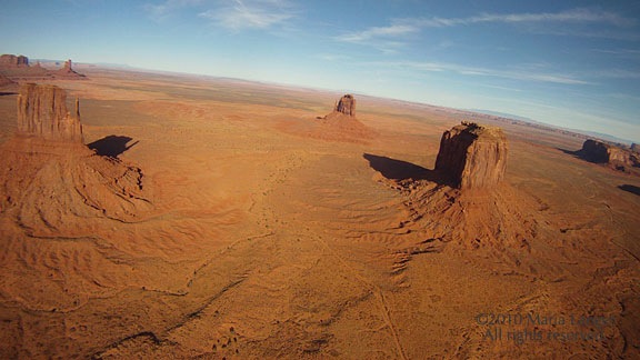
The two Mitten Buttes (East and West) are iconic Monument Valley images.

Monument Valley

I restrict my quick loop around Monument Valley to the west side of the park to minimize noise impact on the ground.

As we came in for a landing, a small herd of horses, spooked by the sound of my helicopter, galloped across the desert east of the airport, kicking up fine red dust.

Landing at Monument Valley

Monument Valley Airport has just one way in and out. Not the kind of airport where you want to overshoot the runway.

It had been a good flight with few bumps or unexpected challenges. Later, in my hotel room at Goulding’s Lodge, I was pleased with the quality of the images my Hero camera had captured. What a great way to document a flight.

Note to Pilots: If you do plan a trip to Goulding’s Lodge, remember that the airport there is private and for use by Goulding’s guests and tour clients only. Go to Goulding’s Web site at www.Gouldings.com to learn more about restrictions regarding airport use.

Flight Planning Realities

It’s more than just drawing a straight line.

Every week I get at least one weird helicopter flight request. Yesterday’s was for a flight from Scottsdale to Four Corners and back.

Four Corners

Four Corners, on a map. (Wikipedia image.)

When I say Four Corners, I’m talking about the place on the map where Arizona, Colorado, Utah, and New Mexico meet. In drawing their rather arbitrary state lines years ago, the mapmakers created this manmade point of interest: the only place in the United State where four state boundaries meet at one point. There’s a monument there that supposedly marks the exact point where the states meet. Tourists like to drive in and get down on all fours for photos with one limb in each state.

These days, the monument is managed by the Navajo Nation, which has land on three of the four states. The Colorado section is on Ute Indian land. I’m pretty sure there’s a fee to get in, but I could be wrong. I’ve driven past the point and flown over it, but have never stopped there.

So the passengers wanted to land at Four Corners, which is on Navajo land. That means I need permission from the Navajo Nation to land there. That’s the first hurdle the booking agent has to jump. (I won’t get permits for my passengers; I’ve wasted enough time trying for flights that didn’t happen.)

The booking agent evidently uses some kind of flight planning tool to estimate flight time. He estimated 2-1/2 hours each way. But the booking agent didn’t take into account the realities of endurance, refueling locations, weather, and FAA reserve fuel requirements.

I used SkyVector — highly recommended! — to come up with a basic flight plan — something I could use to estimate the cost of the flight. Its built-in aeronautical charts make it easy to identify places to stop for fuel if needed.

I learned that a direct flight from Scottsdale to Four Corners would take approximately 2-1/2 hours — just as he’d estimated. But this didn’t take into consideration the possibility of headwinds and my aircraft’s endurance. I roughly estimate 3 hours endurance on full tanks of fuel. But could I fill the tanks? I had no idea what the passengers weighed yet. And with my 20 minutes of required reserve fuel, planning a direct flight was not a good idea.

But what made it a really bad idea is that there is no fuel available between Winslow, AZ and Four Corners — a distance of 143 NM or 1-1/2 hour of flight time. Indeed, the closest fuel to Four Corners is 42 NM to the east — not on our way back — at Farmington.

My Flight Plan

SkyVector makes preliminary flight planning very quick and easy.

That meant I needed to plan three fuel stops: Winslow (INW) on the way up and Farmington (FMN) plus Winslow (INW) or Payson (PAN) on the way back. The resulting flight path is a narrow triangle totaling 549 NM and at least 5-1/2 hours of flight time. To be on the safe side, I’d estimate 6 hours.

This is what kills me about some of these booking agents. This particular one is based in Atlanta, GA. I can pretty much guarantee he’s never spent any time in an aircraft over the Navajo Reservation — which is where at least half this flight would be conducted. He has no concept of the vast distances and empty terrain a route like this would cover. He — and likely his passengers — can’t conceive of the utter boredom of six hours flying over this area. Sure, there are scenic parts, but not six hours worth. They’d be paying me close to $3,000 for this one-day adventure.

And all for what? A photo opportunity at a manmade “monument” in the middle of nowhere? Heck, look at it on GoogleMaps! There’s nothing there or anywhere near it!

Yet the booking agent will sell it to them if he can. And I’ll provide the service if it’s paid for.

I think the booking agent could do them a better service by selling them a Sedona tour or a trip up to the Grand Canyon. Or even Lake Powell, for Pete’s sake! Closer, cheaper to visit, and far more interesting.

Of course the weird requests of uninformed passengers or booking agents isn’t really my point.

My point is this: There’s a lot more to flight planning than simply measuring the distance between two points. The preliminary flight plan I cooked up here is just the first part of a lengthy planning process I have to go through if I get this job.

I have to admit that I find it a bit annoying when a booking agent oversimplifies the requirements of a flight — especially if he fails to inform his clients about what they’re getting into. In this case, it’s a long and expensive flight over the high desert of Arizona with very little of interest to see along the way.

[Another] Predawn Flight to Scottsdale

Flying before the day begins.

I had an early flight in Scottsdale yesterday. Three passengers wanted a custom tour of the Phoenix area.

The man who booked it kept asking to do it earlier and earlier. First 8 AM. Then 7:30 AM. Then 7:00 AM. And then 6:30 AM. “We’ll meet you at 6:15 AM,” he finally said. “Will the pilot be ready to fly right away?”

I assured him that the pilot would be ready to fly within 10 minutes of meeting them. I didn’t mention that the pilot would be me. I hung up, glad he hadn’t shifted the flight another fifteen minutes earlier.

The helicopter was in Wickenburg. Although I’ve been storing it in Deer Valley for most of this season, I took the month of March off. There were a few reasons for it, including two trips (that were eventually postponed). So I had to fly the helicopter down to Scottsdale from Wickenburg — a 35-minute flight — before meeting the clients. When I calculated my departure time, I realized I’d have to leave my house by 5:00 AM to make it on time.

I set my alarm for 4:20 AM. I woke up at 3:30 AM. I showered and thoroughly enjoyed a cup of coffee with Alex the Bird and Jack the Dog. Then I packed up my laptop and flight manifest, shut off the lights, and stepped out to start my day.

It was dark outside. The moon had set, but I could see stars. That meant it was clear. The weather forecast looked as good as it usually does, so I wasn’t expecting any difficulties on the flight. The only questions were about the client: Had he lied about the weights of the passengers? Would he really give me 90 minutes of flight time, making the trip worthwhile? (He wasn’t paying for my ferry time, so a short flight would make the trip a loss.) Would he really be at the airport by 6:15?

I drove to the airport in my Ford truck, passing just a few cars and trucks along the way. The green-white-green-white sweep of the rotating beacon cut through the night as I pulled into the drive. I paused long enough to enter a combination on a keypad and wait while the metal gate rolled aside with a beep-beep-beep. Then I steered the truck down the asphalt drive, turned into the first row of hangars, made a broad U-turn, and parked in front of my hangar’s left door, with my headlights facing out. Even though the motion-sensor lights we’d installed over the hangar door went on, I’d need my truck’s headlights to see the combination on the padlock that secured the hangar. Once unlocked, I rolled the right door all the way open on the track and flicked on the lights. The big box hangar filled with light and the steady hum of the overhead fluorescents. I killed the lights on my truck before they killed the battery.

I’d done most of my preflight the afternoon before, after washing the helicopter and putting it away. I’d debated leaving it out overnight, but decided against it in case the client cancelled at the last minute. If I’d left it out, it would have saved me 15 minutes of time that morning. Instead, I had to use the ground handling equipment — a golf cart, a tow bar, and a set of ground handling wheels — to get the helicopter out onto the ramp. I backed the golf cart out of the hangar, towing the helicopter out nose first. Then I turned off the lights in the hangar and rolled the big door shut, securing it with the padlock again.

It was quiet and dark as I backed the cart out onto the ramp. Some of the overhead lights out on the ramp don’t work. It didn’t matter much to me — I wouldn’t park under any of them anyway. I needed room for my rotors to spin; it simply didn’t make sense to park next to a pole. But the ramp was too dark to see what I was doing. I had to turn on the golf cart’s headlights to unhook the tow bar. I’d never used them before and was rather surprised to find that they worked.

With the ground handling equipment out of the way, I climbed into the cockpit and went through my startup procedure. It took two tries to start the engine; not enough priming the first time for the cold. The engine roared to life and I flicked the appropriate switches to get the blades turning, battery charging, and radios working. I clearly heard the relatively high-pitched whine the engine — or something else back there — makes when it’s cold out. I knew from experience that the sound would go away as the engine warmed up. I turned on the navigation lights, which also illuminated the instruments. The green position light beneath my door reflected in the dusty surface of my side window.

I plugged my iPod into the intercom system. I’d listen to music on the way down.

It took a long time for the engine to warm up. While I waited, the guy in the hangar across from mine drove up and parked in front of his hangar. It was 5:30 in the morning — a full hour before sunrise — and the guy didn’t have a plane. What the hell was he doing there? He spent more time at the airport than most aircraft owners did, usually just sitting in his truck and talking on the phone. It creeped me out.

When the cylinder head temperature had sufficiently warmed, I did my mag check and needle split. I loosened the frictions and brought the engine and rotor RPM up to 102%. I was ready to go.

It was still very dark.

I made my radio call: “Wickenburg traffic, helicopter Six-Three-Zero-Mike-Lima is on the ramp, departing to the southeast.” I flicked on my landing lights, surprised, as always, by the sudden glow and the brightness of the dust particles swirling around in my downwash. Then I lifted into a hover, used the pedals to point the nose at the taxiway, and eased forward, climbing gently. When I reached the taxiway, now eight feet off the ground, I banked right and followed the pavement on a heading of 50°.

Wickenburg at Night

This photo by Jon Davison of us landing at Wickenburg at night gives you an idea of what the view from the cockpit looks like with the runway lights on.

The landing light shined down on the taxiway and out ahead of me as I gathered speed and altitude. I was about a quarter of the way down the taxiway when I realized I’d neglected to turn on the runway lights. I pressed the mic switch seven times. Nothing happened. I tried again, more slowly. The runway lights came to life: two strands of glistening white pearls turning to orange and then to red as they receded into the distance. The taxiway lights, glowed blue in a pair of light strings to their right beneath me. Beyond them was the dark void of empty desert and the greedy dreams of a failed real estate project. Aligning myself with the taxiway lights, I climbed out into the night. I flicked the switch to kill the landing lights.

The lights of Wickenburg spread out before me like a handful of gems cast into the desert by a giant. As I gained altitude to clear the invisible mountains just south of the town’s center, the distant glow of the Phoenix area came into view on the horizon, blocked here and there by the dark shapes of mountains that lay between me and the city beyond. I continued to climb. My goal would be to clear all those little mountains so I wouldn’t have to worry about hitting them in the dark.

I’ve flown the route between Wickenburg and Scottsdale many times. I even flew it at least one other time before dawn. But this time, I was tuned in to the darkness and silence of the night. I pressed the play switch on my iPod, letting some classic rock accompany the steady hum of my engine and the beat of my rotor blades. I climbed to 4,000 feet MSL — more than fifteen hundred feet over the desert below me — and leveled out. I was clear of all mountains between me and my destination.

Once away from Wickenburg, below me was only the darkness of the empty desert. With no moon, there was barely enough starlight to make out the meandering lines of dry washes and the occasional dirt road. Without visual landmarks, I realized I didn’t know where I was. Was that the Santo Dominguez Wash? Or one of the lesser washes in the area? And how about those lights to the left? Campers? Or that ranch off Constellation Road, viewed from a different angle? Only my GPS and the view of Phoenix’s lights spread out in the distance before me assured me that I was heading in the right direction.

The sky brightened ever so slightly as I glided southeast. The air was calm and smooth; my helicopter could have been a skiff floating on glassy water. I crossed over a well-defined dirt road that had to be Castle Hot Springs Road. Then I recognized the lights of the Quintero golf course and vehicles on Carefree Highway. The brightening sky reflected in Lake Pleasant, far to my left.

After ten minutes of flying over empty desert, I was returning to civilization: the northern reaches of Peoria.

I descended through 3500 feet, feeling ridiculously high above the ground as the glow from lights below me started reflecting in the inside of my cockpit bubble. I turned up the brightness on my instrument lights just a bit. Still descending, I flicked the radio to listen to the ATIS at Deer Valley. It was 5:50 AM and the tower was still closed. The automated weather observation system reported calm winds and an altimeter setting of 30.04. I adjusted my altimeter while listening to the recorded voice of the controller who’d closed the tower the night before. The tower would open at 6 AM. I wondered whether I’d reach the airport before then. I tuned the radio to the common traffic advisory frequency for Deer Valley, made a radio call with my position ten miles out, and continued on a course that would take me right over the top.

Lights at Night

The lights of the Phoenix area, at night. Photo by Jon Davison.

To the south, the brightness of lights on the ground intensified. The area was packed with new subdivisions, some completed before the housing bubble burst while others still had empty, weed-filled lots beneath their street lamps. It was a sharp contrast to the empty desert I’d been flying over for most of the trip. It amazed me that people wanted to live like that — packed like sardines into bulldozer-groomed lots — when there was so much beautiful desert, with rolling hills, cactus, and natural landscaping only a half mile away. The wide open spaces are what drew us to Wickenburg in 1997, but even that small town wasn’t immune to the greed of developers. Town planning restrictions were overturned on a case-by-case basis — often against voter’s wishes — for favored developers, resulting in smaller and smaller lots. Land zoned as horse property was rezoned to keep horses out and make lots too small to have them anyway. The retirees bought second homes in town to escape the cold of the midwest, doubling the population — for half the year, anyway. A friendly little western town turned into a retirement community right before our eyes. All of our young friends moved on to places like Colorado and New Mexico and California, leaving us with the retirees.

But I’m not ready to retire from life.

I descended to 2500 feet — a good 500 feet above where I normally flight during daylight hours — and leveled off. At five miles out, I made another call to Deer Valley traffic. I was now crossing into Deer Valley’s airspace; if the Tower had been occupied, I’d have to establish radio communication with the controller. I was the only one on the radio though — no one else spoke up. I crossed over the Central Arizona Project (CAP) canal where it meets the I-17 freeway. The sky, now quite bright, reflected in its smooth waters, drawing a bright line to the southeast.

Two miles from Deer Valley, I made another position call. No answer. I was close enough to see the tower; there was some light up there. Towers are normally kept dark so the controllers can see outside without bothersome reflections. A moment later, the airport’s two runways stretched out below me. I didn’t bother turning on the lights; I wasn’t landing and didn’t need them. But I could still see them quite clearly in the predawn light. It was about 5:58 AM and I expected the tower to open at any minute. I used the radio to announce that I was over the top and transitioning to Scottsdale. No answer. I glided on my way, descending down to 2300 feet.

Horizon

In this last shot by Jon Davison, you get an idea of how the horizon looks before dawn. (This shot was actually taken after sunset.)

Now the lights were bright below me as I flew over one subdivision after another. I crossed the Loop 101 freeway. Ahead of me, I could see the rotating beacon at Scottsdale Airport, about 12 miles away. The black bulk of the mountains on the horizon were well defined with sharp edges against the bright sky. Four Peaks was clearly identifiable by its four individual peaks.

I used my second radio to listen to Scottsdale’s ATIS while remaining tuned into Deer Valley. That airport was still closed, too. The automated weather system reported light winds and an altimeter setting just a few hundredths off from Deer Valley’s. The recorded controller’s voice warned of an unlighted 150-foot construction crane and advised that the tower would open at 6 AM. I flicked the recording off.

Now I was wondering about my client again, wondering whether he’d show up on time, whether he’d lied about his weight, whether he’d give me more than the 90 minutes of flight time he promised. I’d know soon enough.

The sound of a telephone dial tone came through the radio in three short bursts. Then the Deer Valley controller came on. He sounded tired and depressed, as if he’d just woken up to bad news, as he read the standard tower opening statement over the radio. It was long. I was still in his airspace, so I listened. At the end, he said, “Helicopter Zero-Mike-Lima, traffic ahead and to your left is a helicopter at twenty-five hundred feet. Frequency change approved.”

I’d already seen the helicopter flying west along the north side of the Loop 101. I replied: “Zero-Mike-Lima has that traffic in sight. Changing frequencies. Have a good day.”

I switched over to Scottsdale tower with the flick of a button. A female controller with a bright, bubbly voice was giving instructions to a jet preparing to take off.

I waited until she was finished and the pilot had replied, then made my call: “Scottsdale Tower, helicopter Six-Three-Zero-Mike-Lima is seven to the west off Deer Valley landing at the terminal.”

“Helicopter Zero-Mike-Lima, proceed inbound, report a half mile west.”

“Will report a half mile west, Zero-Mike-Lima.”

I continued inbound, crossing over Route 51. The sky was much brighter now; dawn was only 30 minutes off. I continued my descent to 2000 feet, roughly 500 feet over the ground. I listened to the tower talk with a female airplane pilot with the call sign “Traffic Watch” and wondered what kind of traffic she could watch from an airplane. Maybe I’d misheard them. She was using Runway 3.

Then I was less than a mile out and ready to start my final approach. I reported my position and was cleared to land on the ramp with the usual “use caution; ramp uncontrolled” and “remain west of the runway and taxiway at all times.” I repeated the “remain west” restriction as I steered to the south, descending. When I was abeam the approach end of runway 3, I swung northeast and lined up with the ramp, parallel to runway 3 and the taxiway beside it. I came in behind all the jets parked on the ramp and hover-taxied beyond them to transient parking for small airplanes. I set down at the end of the “Reserved” row and started my shutdown procedure.

In front of me, the terminal’s empty windows reflected the bright glow of the predawn sky, along with the flash of my helicopter’s strobe light. It wasn’t night anymore, but it wasn’t really day, either. It was that in-between time, the time of day when you put the secrets of the dark night behind you and prepare to embrace the day. It’s a special time, a time that’s always calm, always reflective. A time that makes me feel good to be alive.

I shut down and went inside the terminal. It was 6:10 AM.

And in case you’re wondering, the passengers did show up, they lied by a total of 50 pounds about their weights, and they flew with me for a full two hours.

Blogging the FARs: Avoid the Flow of Fixed Wing Traffic

What it means — and doesn’t mean.

I was at Wickenburg Airport for a short time yesterday and was dismayed to see another helicopter pilot practicing autorotations using a left traffic pattern for the taxiway parallel to Runway 23. In Wickenburg, it’s right traffic for Runway 23, keeping the airplanes on the northwest side of the runway. There are fewer houses out that way; a left traffic pattern would have you overflying dozens of homes.

Someone else at the airport told me that the owners of the homes southeast of the runway had asked this pilot several times not to overfly their homes. They were bothered by the noise of his buzzing aircraft just 500 feet over their houses over and over again. He replied that he was supposed to “avoid the flow of fixed wing traffic.” When one of the nicest guys on the airport suggested he fly on the other side, this pilot’s response was, “Fuck you.” Whoa. Seems like someone has an attitude problem.

But is he right? Should he be doing left traffic patterns if the airplanes would be doing right patterns?

The Rules

FAR Part 91.126, “Operating on or in the vicinity of an airport in Class G airspace,” says, in part:

(a) General. Unless otherwise authorized or required, each person operating an aircraft on or in the vicinity of an airport in a Class G airspace area must comply with the requirements of this section.

(b) Direction of turns. When approaching to land at an airport without an operating control tower in Class G airspace —

(1) Each pilot of an airplane must make all turns of that airplane to the left unless the airport displays approved light signals or visual markings indicating that turns should be made to the right, in which case the pilot must make all turns to the right; and

(2) Each pilot of a helicopter or a powered parachute must avoid the flow of fixed-wing aircraft.

To some, it might appear that Part 91.126(b)(2) gives helicopter pilots permission to fly wherever they want in Class G airspace, as long as it’s not anywhere near an airplane. Maybe that’s what our attitude-challenged helicopter pilot at Wickenburg thinks. But I’d argue that it’s simply not true.

Why Avoid the Flow? Why Not Join It?

Wickeburg Airport

Wickenburg Airport, from the approach end of Runway 05.

Helicopters are advised to avoid the flow of fixed-wing traffic mostly because of the significant differences in the way they operate. Helicopters are usually slower than airplanes, they tend to operate at lower altitudes, and they don’t need a runway to land or take off. Putting airplanes and helicopters together in a traffic pattern is like mixing oil and water: they just won’t blend.

But does avoiding the flow of fixed wing traffic mean creating a completely separate traffic pattern? Sometimes, it does.

Does it mean making yourself a noisy nuisance over a residential neighborhood on the side of the airport that normally doesn’t have aircraft flying over it? I say it doesn’t.

And what if there aren’t any airplanes in the traffic pattern? I’ll argue that there’s nothing to avoid so why not use their established, community-preferred traffic pattern?

And that was the problem yesterday: the bad attitude pilot was the only aircraft in the traffic pattern for the entire time he was flying yesterday. There was no fixed-wing traffic to avoid.

There was no reason to overfly those homes.

Fly Neighborly

Although I’m not a big fan of Helicopter Association International (HAI), I do want to commend them on their attempts (although usually feeble) to share information that’s useful to the helicopter community. Among that information is “The Fly Neighborly Guide” they offer as a PDF download from their site. Here’s a blurb about the program from their site:

The Fly Neighborly Program addresses noise abatement and public acceptance objectives with programs in the following areas: 

  • Pilot and operator awareness
  • Pilot training and indoctrination
  • Flight operations planning
  • Public acceptance and safety
  • Sensitivity to the concerns of the community

The point is, lots of people hate helicopters because they’re noisy. (In reality, they’re not all that much more noisy than an airplane. But because they usually fly lower, they seem louder.) By using techniques that help us fly more quietly and avoiding noise-sensitive areas, we’ll blend in with the environmental impact of aircraft traffic much better.

What does that mean to me? Well, here are some of the things I try to do:

  • Maintain speed above 80 knots in my R44 to avoid “rotor slap.”
  • Not fly low over homes, schools, or businesses.
  • Vary the flight path I use to approach or depart the airport.
  • When flying traffic patterns, choose a pattern that does not repeatedly overfly the same noise-sensitive areas. (Yes, the other day when I was practicing autorotations at Wickenburg, I shared the same standard traffic pattern with three airplanes.)

I do need to point out here that anyone who buys a home within 3 miles of an airport should expect some level of noise. If you don’t like aircraft noise, don’t buy a home near an airport. Period.

Why I Care

Why should I care that a bad attitude pilot is thumbing his nose (and perhaps making other hand gestures) at people who complain about his inconsiderate flying?

AFD for E25

The Airport/Facilities Directory entry for Wickenburg.

Well, it’s like this. Right now, at Wickenburg, there is no published noise abatement procedure. Look in the Airport/Facilities Directory and see for yourself. (Try not to notice that the diagram is inaccurate on so many levels.) That means pilots have the freedom to make their own decisions about approaching and departing the airport. We’re not forced to follow some idiotic plan set forth by an ignorant non-flyer in response to noise complaints.

But if Mr. Bad Attitude keeps ignoring the complaints and overflying the same homes again and again, the complaints will get escalated. I’m not too worried about the town doing anything — they’re extremely ineffective when it comes to solving airport-related problems. But eventually, it’ll get up to the FAA. Enough people know it’s not me — a bright red Robinson R44 looks nothing like a little white Schweitzer 300 — so I won’t get in trouble. But the FAA might actually do something to make the complaints go away. Since Mr. Bad Attitude isn’t technically doing anything wrong, the only way to fix the problem is a noise abatement program. The FAA will push the town to make one and we’ll be stuck with it.

What’s also bad is that his continued inconsiderate behavior makes everyone in the helicopter community look bad — including me and the two other helicopter owners based in town. It could cause problems in Wickenburg or other communities for helicopter pilots and operators. It could affect businesses like mine or emergency services. (Come to think of it, one of the reasons our hospital lost its helicopter medevac base was noise complaints. So if you have a heart attack in Wickenburg, you’ll just have to wait an extra 20-30 minutes for help to come.)

And all this is why I care.

In Summary

When helicopter pilots are advised to “avoid the flow of fixed-wing traffic,” that doesn’t mean we should avoid flying in empty airplane traffic patterns. It means we should avoid flying with airplanes.

It also doesn’t mean we should use FAR 91.126(b)(2) as an excuse to become a nuisance by repeatedly overflying noise-sensitive areas.

If there’s no conflicting aircraft, common sense should prevail.

Why I Don’t Buy Fuel at Wickenburg Airport

Why should I?

Early this season, back in November 2009, I realized that if I wanted my helicopter charter business to succeed, I had to move it out of Wickenburg. That meant finding a secure and affordable hangar in the Phoenix area for the times I expected to do business down there. The plan was for my helicopter to split its time between its Wickenburg hangar and one down in Phoenix or Scottsdale, where my customers were.

After making a few calls and visiting a few airport FBOs, I got what I considered a very good deal from Atlantic Aviation in Deer Valley. For less than I pay for my [admittedly large] hangar at Wickenburg, my helicopter would be stored in a spotlessly clean corporate hangar* only steps away from the terminal building at Deer Valley Airport. If that wasn’t enough to sell me, Atlantic’s line crew would move the helicopter in and out for me at no extra cost. And I’d get a significant discount on fuel purchase. Fuel, of course, was delivered to my aircraft from a truck, so I didn’t have deal with dirty fuel hoses and temperamental fuel systems and the occasional “Out of Fuel” sign.

Sounds good, huh? Well it gets even better.

Nearly everyone at Atlantic knows me by name and greets me with a friendly smile and cheerful “Hello!” When I come in from a flight, the folks at the desk offer me (and my passengers) bottles of icy cold water. The restrooms are sparkling clean and — can you imagine? — always have soap, paper towels, and a clean, fresh smell. If I need to wait for a passenger to arrive, I can do so in a comfortable seating area while watching whatever is on the high definition, flat screen television. If I need to park my good car at the airport for a few nights, they’ll take it inside the airport fence for me and park it in a secure area, where I don’t have to worry about airport lowlifes tampering with it.

On the rare occasion when I do have a complaint — the only time I can think of is when my dust-covered helicopter was taken out in the rain for a few minutes and all that dust turned into big, ugly rain spots — my complaint gets handled quickly, to my satisfaction, without any further ado. With an apology that’s meant. It’s like they realize they have a responsibility and they’re ready to take care of what they need to. (In the instance of my helicopter, they actually washed it for me.)

So to summarize: at Deer Valley I get great service from friendly people who know how to do their job. Getting my helicopter out on the ramp, fueled, and ready for me to preflight and fly is as easy as making a phone call. My monthly rent is reasonable and I get a discount on all fuel purchases.

How much of a discount? Funny you should ask. I’m currently paying about 50¢ less per gallon for full service fuel at Deer Valley than I am for self-serve fuel in Wickenburg. Since I burn about 16 gallons per hour, that saves me $8 every single hour I fly. Since I fly 200 hours a year, that can save me $1,600 over the course of a year. (Ironically, when I ran the FBO at Wickenburg, I was the single biggest buyer of fuel in 2003.)

But it’s not just the money I save that has me buying nearly all of my fuel at Deer Valley these days. It’s the service. That’s something you simply can’t get these days in Wickenburg.

Think the situation at Deer Valley is unusual? Then look at yesterday. I had a charter originating at another Phoenix area airport — one I rarely use. When my passengers arrived, I immediately noticed that one of them had trouble getting around. Since the helicopter was parked quite a distance away from the terminal, I asked the guy at the desk if they could run us all out to the helicopter in their golf cart. No problem. They had the cart ready at the ramp before we even reached it. When I returned from the flight, a quick call on the radio had the cart back in position before my blades had even stopped. But the kicker? When I discovered that the per gallon price of fuel was a penny higher than it was in Wickenburg, I asked for a discount. And even though I only bought a total of 43 gallons (10 before the flight and a top-off after it), they took off 20¢ per gallon.

Other airport FBOs also provide real service. Scottsdale’s Landmark Aviation greets me with a golf cart, offers me and my passengers bottles of water and fresh-baked chocolate chip cookies. On a recent trip, they even arranged ground transportation for my passengers. I get service at nearly every airport I go to: Falcon Field, Sky Harbor, Glendale, Sedona, Grand Canyon, Page, Monument Valley, Flagstaff, Winslow, Lake Havasu, Bullhead City, Parker — the list goes on and on.

Except Wickenburg.

Wickenburg’s terminal building is kept locked up tight unless they’re expecting a jet. There’s no one there to greet you — let alone smile at you. The bathrooms, which are accessible via keypad-locked door, are usually dirty and seldom have soap. There’s no counter to set down your sunglasses or purse; the moron who redesigned them obviously cared more about how it would look when new than how functional it might be. There’s no comfortable place to wait or to greet passengers. The pop machine is locked up inside the building, so if you’re thirsty, you’re out of luck. The fuel hoses are dirty, the nozzles leak, the static cable has burrs that’ll cut your hand open if you’re not careful. The only fuel truck is for JetA and it’s only available if you call ahead. If no one answers the phone, you’ll be pumping your own JetA, after taxiing your multi-million dollar aircraft up to the self-serve pump. The windsocks aren’t replaced until they’ve rotted away and the pilots complain. And if you’re in a helicopter, be careful of the FOD on the ramp — some of the short 2x4s they use as chocks tend to become airborne in helicopter downwash.

There’s virtually no airport security and airport management — which barely exists — doesn’t seem to care about the airport’s resident low-life, who vandalizes airport and personal property and steals things from the parked vehicles of people he doesn’t like.

I don’t know any local pilot who buys fuel in Wickenburg if he doesn’t have to. For most of them, though, the issue is price. That’s enough to keep them away from the pumps. I don’t think they expect the kind of service a real FBO offers. They just think Wickenburg charges too much for fuel — and they’re right. How can you charge more that most airports in the state when you don’t provide any services to go with it?

What are people paying for?

I know what I’m paying for. And I’m not buying it at Wickenburg Airport.


* To be fair, Atlantic’s hangar in Deer Valley is a shared hangar. The only thing I can store there is my helicopter, its ground handling equipment, and a storage locker for small items such as the dual controls, life vests, and extra oil. It’s not as if I’m getting a cheap private hangar; I’m not. This is, however, what I need on a part-time basis, so it works extremely well for me.