Racing [with] Boats

What a rush!

My Lake Havasu job on Friday turned out to be two jobs.

I’d been hired by a man based in Oregon who had designed and built a totally custom, stainless steel speedboat. His company, Liquid Technologies, had brought the boat down to Havasu to participate in a big boating event there. It was the second time the boat was in the water and he wanted to get video of the boat out on the lake. He’d hired Todd from Joker’s Wild Promotions to do the camera work.

Todd met me at the airport at 8 AM on Friday. He decided to sit behind me in the helicopter, so we’d both have pretty much the same view. We took just that door off. It was still cool and the last thing I needed was to catch a cold. Then we put on our life jackets and climbed on board.

Todd told me the game plan as I warmed the engine. The boat would be at the cove at the Nautical Inn, just southwest of London Bridge. We’d go there and circle it as it backed out, then follow it slowly through the no wake zone to the open lake. Then the boat would cruise at about 50 knots and we’d fly with it.

He asked how low I could fly. I told him I didn’t know — I hadn’t flown with a boat before. He told me to stick with my comfort level. No problem there — I’d never do anything I wasn’t comfortable with.

We took off and got to the cove within minutes. The boat was about 45 feet long and silver, looking very sleek. It was surrounded by literally dozens of similar boats, most of which had bright paint jobs, just parked along the cove. We circled the cove three times as it backed out, getting lower with each pass. Then we followed it.

The day was perfect for flying. Little or no wind, still cool and comfortable. The lake water was almost mirror smooth. Zero-Mike-Lima seemed to have all the power in the world with just two of us on board, even with close to full tanks of fuel.

The boat had four men in it, each wearing life jackets and headsets. They did their absolute best not to look at us. That turned out to be a pain in the neck later on, when Todd wanted them to speed up and they never saw his hand signals. We followed them down the lake at a good clip and I got closer and lower in gradual steps. After a while, I was about 15 to 20 feet off the top of the lake, 30 feet from the boat, cruising along beside it at 50 to 60 knots.

Todd gave me instructions to position us in relation to the boat. In front, looking back. Behind, looking forward. Above, looking down. Low, looking straight on. I followed his instructions, keeping an eye on the boat and on the lake in front of me. There were only a few boats out there and I didn’t want to overfly any of them at low level, so once or twice I had to shift position to dodge around another boat.

What’s interesting to me about all this is that I didn’t have to give the flying much thought. Both hands and feet just did what they needed to do to get the helicopter where I wanted it to be. I’d expected the work to be challenging and to require a lot of concentration to do. But it wasn’t that difficult at all. I think it’s because of the flying conditions — which were so darn easy — and the power available to me. There’s no way I could have done the job as easily in an R22 with its limited power and two good-sized people on board.

We got down to the pumping station for one of the two reservoirs near the Parker Dam and I saw an unpleasant sight: high tension power line towers. “I think there are wires ahead,” I said to Todd.

“Oh, yeah,” he said. “I forgot to tell you about them.”

Great. “Well, I want to stop before we get to them,” I said.

He assured me that that’s as far as they’d go. I stopped over the water, climbed up a bit, and went into a slow circle about a half mile upriver from the wires. The boat kept going, then turned around and came back to us. Then we started up again, now going upriver. We started getting fancy, coming up behind the boat, passing it, and flying around its front end as it sped by us. A maneuver very similar to one I’d done at a carmaker’s test track for a film crew months before. Todd was very pleased.

We got back to town and they boat turned around again. Todd switched to still photos. He had a professional Canon camera capable of 6 shots per second at 8 megapixels. We followed the boat about 1/4 back down the lake. It turned and came back. More still photos, more video.

Then we were done. We headed back to the airport. The 1.2 hours of Hobbs time had gone quickly.

I asked Todd how I’d done. He said that I was now his current favorite pilot. Unfortunately, he doesn’t want to pay my ferry costs from Wickenburg (1.6 hours round trip), so I don’t know how much work he’ll give me in the future.

We shut down and I closed up the ship. Then we went into town, where he dropped off the video and still photos at his office. One of the guys who works with him, Larry, wasted no time feeding the video into a computer. I got to see some of it. The beginning wasn’t too impressive as I warmed to the task and Todd got used to a new video camera. But then there were a bunch of great sequences. He had over 45 minutes of raw video to go into a 10-minute final video. The still photos were even better. I got to see them on Todd’s computer. He promised to send me a few; maybe I’ll get to show one or more of them off here.

Larry dropped me off at the Nautical Inn, where I met with the client and presented my bill. He was a nice man, excited about the sport and his new boat. He paid me with a check and I left them to find my next client.

Todd had gotten me hooked up with the guys from Extreme Boats magazine. They wanted to get photos of some of the other speedboats as they went downlake for a “lunch run.” So I met with Casey, the magazine publisher, and hitched a ride out to the airport with him and two other guys from the magazine. The other guys left us at the helicopter and a video guy joined us a while later. I took off two doors, stowed them in the video guy’s truck, handed out life vests, and we climbed aboard. A while later, we were on our way back to the cove south of the bridge.

This flight would be significantly different. There were a bunch of boats to shoot and they were all waiting for us. A soon as they caught sight of the helicopter, they took off downlake. Although I was already moving at close to 100 knots, these guys weren’t planning on cruising at only 50. They were race boats and they wanted to race. With a helicopter.

I caught up with our first target boat and dropped down to lake level. I was flying at 90 knots, 20 feet above the water’s surface, and got a real rush out of the experience. Casey snapped away at each boat — his camera could do 8 shots per second at 8 megapixels — then instructed me to chase down the next one. I’d do what I could — some boats were just too fast and too far ahead to catch up with — and then we’d turn around and head back up the lake looking for other boats to shoot.

This was entirely different from the morning’s shoot, which I now considered a training exercise. This was closer to real life race boat photography. The only difference here is that the drivers weren’t in a real race. They wanted the helicopter to take pictures of them. So when they saw me drop back and pick up another target, some of them turned around and chased me down.

To further complicate matters and make it a bit more challenging, it was after noon and the lake was full of boats. Dodging them became a real chore, but overflying them was not an option at that altitude for safety reasons. There was a slight breeze that occasionally sent a ripple of air over the water — just enough to give the helicopter a vertical wiggle. A downdraft — even a slight one — was not something you wanted when you were only 15 feet off the water’s surface.

Meanwhile, the video guy shot some video out the bubble and through his open door. One of his targets was a boat full of girls promoting David Clark products. We were racing along beside them and he was shooting what was probably excellent video when one of the bimbos on board decided to stand up and moon us.

“What the hell is she doing?” one of the guys said.

“We’ll have to edit that out,” the other guy said.

The guys obviously weren’t amused. Sometimes women can be so stupid that I’m embarrased to be one.

We flew around the lake for about an hour, chasing boats, trying to pass them for bow shots, and sometimes succeeding. One of the boats we were supposed to shoot was having engine problems and was dead in the water. They didn’t shoot any pictures or video.

On the way back to the airport, Casey told me about how one of his photographers had taken a swim in an R22. The pilot had been flying so low along the water that he routinely dragged one or both skids along the water surface. The photographer had asked him several times to fly higher, saying that if he wanted photos from that low, he’d be in a boat. The pilot evidently hadn’t gotten the message. On one of his low dips to the water, he dug the skid in too deeply and it caught. The helicopter flipped over and sank. The pilot and photographer were okay, but I wonder whether the pilot learned his lesson.

I don’t think I’d impressed Casey as much as Todd. I like to think that isn’t my fault — that the boat driver’s desire to race with a helicopter — and beat it — had made me look bad. But my helicopter’s never exceed speed with doors off is 100 knots. How can I be expected to catch up with and pass a boat going faster than that?

I settled up with Casey and spent a half hour relaxing in the FBO while the fuel guy topped off my tanks. (There’s still a price war going on at Lake Havasu City Airport and the fuel at Sun Western Flyers is cheaper than in Wickenburg.) It was about 2 PM when I climbed on board and headed home.

Page to Havasu by Helicopter

I fly from one gig to the next.

I had two long distance flying jobs this past week: one in Page, AZ and the the next in Lake Havasu City, AZ. Although the two cities are on the Colorado River, they’re 200 miles apart by air.

My Page job ended at around 6:30 PM on Thursday. With sunset less than an hour away and dark clouds on the southern horizon, flying home was not an option. That didn’t matter; I was prepared for an overnight stay.

The FBO guy at Classic Aviation gave me the courtesy van for the night and I drove into town. A while later, I was checked into a comfortable first-floor room at the Best Western Hotel, with a “Manager’s Special” rate of only $65. Dinner was across the street at the Lake Powell Steakhouse, one of those small-town restaurants that features a soup and salad bar no one would miss if it weren’t there. They had a wine list and I ordered a half bottle of Clois du Bois cabernet — which actually came in a little bottle with a real cork — to go with my prime rib. I couldn’t finish the wine with dinner, so I corked it back up and took it back to my room, where I finished it off out of a styrofoam coffee cup.

I watched a little television before passing out at around 9 PM. I was awake at 3 AM. I’ve been having trouble sleeping lately — have a lot on my mind. I spent some time writing about the day before. Then, at 5 AM, I washed up, dressed, and packed up. I was getting back into the van at 5:30 AM.

Sunrise over Navajo Mountain
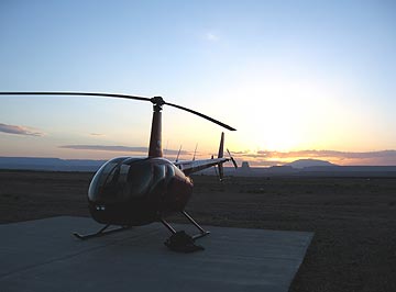
I dropped off the van at the airport, leaving the keys tucked inside the van’s logbook under the seat with a $10 contribution for fuel. It took five tries to get the combination right on the locked gate to the ramp. There was no one around. I walked out to the helicopter just as the sun was rising over Tower Butte and Navajo Mountain to the east. The air, which had been completely still, now stirred to life with a gentle breeze. There was enough light for a good preflight and I took some time stowing my bags and the life jackets so I’d be organized when I arrived at Havasu.

Glen Canyon Dam
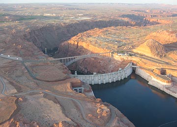
I started the engine and warmed it up, giving the engine plenty of time to get to temperature. (Take care of your engine and it’ll take care of you.) At exactly 6 AM — right on schedule — I raised the collective, made a radio call, and took off toward the lake. I swung over the dam for a look and a photo before heading down the Colorado River, over Glen Canyon.

I had a long flight ahead of me.

The Vermilion Cliffs
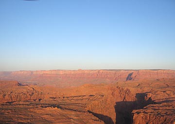
My flight path would take me south along the eastern edge of the restricted Grand Canyon airspace. In a way, it was ironic — less than two years ago, I’d earned part of my living as a pilot flying over the canyon every day, but now I can’t fly past the imaginary line that separates that sacred space from the not-so-sacred space I was allowed to fly. That didn’t mean I didn’t have anything to see. As I flew past Horseshoe Bend and over the narrow canyon, I could see reflections of the canyon wall on the slow moving river below. To the west were the Vermilion Cliffs with Marble Canyon at their base.

The air was wonderfully smooth — as it usually is early in the morning. I could fly at dawn every day. It’s cool and crisp and clear. The sun hasn’t warmed the desert yet so there are no thermals to bump you around. The helicopter goes exactly where you tell it to. Sometimes, it’s like sitting on a lawn chair in an enclosed bubble, guiding yourself over the landscape with gentle pressure on the stick in your right hand. My iPod was connected and turned on with hours of classic rock music to keep me entertained while the radio remained quiet.

Navajo Homesteads
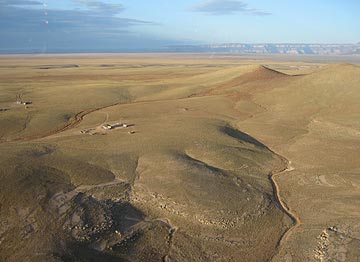
I detoured slightly to the east, keeping to the left of the green line on my GPS that marked Grand Canyon’s airspace. The red rock terrain gave way to rolling hills studded with rock outcroppings and remote Navajo homesteads. I flew low — only a few hundred feet up — enjoying the view and the feeling of speed as I zipped over the ground, steering clear of homes so as not to disturb residents. I saw cattle and horses and the remains of older homesteads that were not much more than rock foundations on the high desert landscape.

Ahead of me, past the Little Colorado River Gorge and route 64, were the cliffs that marked the southern boundary of the reservation. I’d have to climb 2,000 feet to clear them. But above them was a layer of low clouds. From my position near the ground, it almost looked like a fog bank sat on top of the higher plateau. That would be bad news and mean a course change. I started to climb, leaving the earth behind.

Once I was level with the cliff’s edge, I could see that there was some clearance between the plateau and the clouds above it. I reached the southeastern corner of Grand Canyon’s airspace and programmed my GPS for a direct course to Lake Havasu City airport. I turned to the desired course, putting the little airplane on the pink line, and crossed onto the plateau about 300 feet over the top of the cliff. The clouds closed in above me. I split the distance between them and the high desert terrain, flying at about 8,000 feet MSL.

I knew the terrain below me well. Coming from the south, the terrain rose gradually to its highest point at the edge of the cliff. Now, coming from the north, it would descend. I was moving southwest, over tall pines and meadows just like the ones I flew over when I flew at the Grand Canyon. My handheld GPS showed a maze of forest roads and I was surprised to see a handful of ranches I’d never noticed before. But I was on a different course now, not heading toward Howard Mesa or Wickenburg.

The air remained smooth, despite the clouds. The weather was worse to the south. It was cold in the cockpit — although I’d worn long pants, I’d neglected to put a sweatshirt on over my polo shirt. I pulled the heat on.

I switched to Grand Canyon airport’s ATIS frequency. It was still early and the tower hadn’t opened yet. The automated system gave me the winds (light out of the south) and altimeter setting. Then I switched to the tower frequency. I was just passing between Valle and Tusayan when I heard a Scenic Airlines plane make a CTAF radio call. I’d hear him three more times before he finally landed and I was miles away.

The cloud bank ended abruptly, leaving me in the sunshine of a beautiful day. The ponderosa pines were gone and I was flying at about 6500 feet now, over remote ranch land. I’d set my sights on a mountain in the distance to keep on course and the mountain was getting ever closer.

Mountains Near Seligman
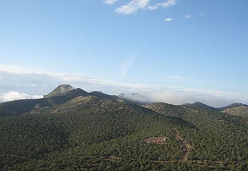
Then there were more homes beneath me and pinon and juniper pines. Wisps of low clouds clung to the mountains at my altitude. Past the mountain I’d been aiming for was the town of Seligman on Route 66 and I-40. I crossed over with a quick radio call to the airport and kept going.

Now I was flying over completely new terrain. It was a pleasant mix of tall pines, rocky outcroppings, and rugged mountain peaks. There were a number of nice but mostly small custom homes on large lots below me. They looked, for the most part, deserted — like vacation homes. A sort of Howard Mesa where they actually cared about what people built.

I followed the pink line over a mountain range, flying at about 6,000 feet MSL. Then came a familiar valley — the one route 93 follows up to Kingman. The Big Sandy River was below me and the Hualapai Mountains were in front of me. Rather than dropping down to the valley floor, I kept high, crossing at at least 3,000 feet above the ground so I wouldn’t have to climb again to cross the mountains. At that altitude, I seemed to move at a snail’s pace, although my GPS indicated 120 knots groundspeed. I still had to climb to clear the mountains.

All the time I flew, I kept checking my clock with my GPS’s ETE. Throughout the flight, it appeared that I’d make it to Havasu with about 5 minutes to spare. My airspeed was limited by my altitude — I couldn’t pull as much power or fly as fast at 6,000 feet as I could at 3,000 feet. With that last mountain range behind me, I descended quickly toward the valley floor, bringing my airspeed up to 120 knots with only a slight reduction in power. When I was about 500 feet above the valley, I brought power back in and kept my airspeed at 120 knots.

I switched to Havasu’s frequency and heard a plane call in. I was almost there. Then I passed between two small peaks and followed a wash to the east side of the airport. After two radio calls, I crossed the runway and set down on the ramp.

It was exactly 8 AM.

Flying At Lake Powell

A beautiful place from the air.

If you’re a pilot and want to fly at the lake, you might be interested in my series, “Tips for Flying at Lake Powell“:
Part I: Lake Powell and the Airports
Part II: Avoiding the Tour Planes
Part III: Points of Interest
Part IV: Going Way Uplake

About a month ago, I was contacted by a professional photographer named Mike who lives in the Chicago area. He and several of his friends were planning a photographic excursion to the southwest. They wanted to hire a helicopter for a photo shoot over Lake Powell.

About Lake Powell

If you don’t know anything about Lake Powell, here’s the short story. It was created back in the 1960s when the government built the Glen Canyon Dam on the Colorado River near what is now Page, AZ. It took only seven years to fill the huge lake with water. It acts as a reservoir, produces hydroelectric power, and offers recreational activities including boating, houseboating, water skiing, etc. Recently, the Navajo Nation built a marina at Antelope Point (near the entrance to Antelope Canyon) to generate sorely-needed revenue from on this huge lake in their backyard. The lake sits on the northeastern side of Arizona, stretching northeast into Utah.

I’d been houseboating on Lake Powell twice. I love it. Miles and miles of twisting canyons branch off from the main channel of the river. The shoreline is endless, the rock formations, cliffs, and hidden ruins are enough to keep any explorer busy for a lifetime. If I had my choice of living anywhere in the world, I’d live on a houseboat on Lake Powell. I love it that much.

Of course, there is a movement among conservationists to drain the lake. They claim that the Glen Canyon area was beautiful before the dam and that the lake has destroyed that beauty. They also point out numerous townsites and ruins that were inundated when water levels rose. My response to these people is that it’s too late. The damage is done. And how can you truly fault the decision makers for making some of the most remote desert terrain accessible to the general public? It could have been worse. They could have flooded the Grand Canyon, as they’d planned years ago. Or Yosemite. And come on, guys — we know there are many more beautiful places out there that are just as remote and inaccessible as Glen Canyon was.

Preparing for the Trip

Anyway, after getting the call from Mike, my first task was to call the National Park Service to make sure I could do such a flight. The airspace over Grand Canyon is regulated and I wasn’t sure what kind of regulations existed for The Glen Canyon National Recreation Area, in which the lake sits. I spoke to a ranger in the law enforcement area. He told me that I could do the photo shoot. He suggested that I not fly low over any of the marinas (duh) and reminded me that landing was prohibited anywhere except at a landing strip.

Mike and I made arrangements. I explained I’d need a credit card number and would charge him $1,000 if I flew up to Page and he cancelled. He was fine with that. We set two dates — one in case the first was bad weather — and I sent him a contract.

The month passed quickly. I’ve been unbelievably busy with the helicopter these days, actually making money with it. It seems that my rates are lower than rates charged by other companies with similar (or better) equipment. Even when I charge for ferry costs, my total cost is far below other companies. Understand that I’m not trying to undercut anyone. I just have much lower overhead and am satisfied with a smaller chunk of profit. So my phone has been ringing incessantly. This week, for example, I had custom charters totaling an estimated 16 hours of flight time. While that might be peanuts for large operators, it’s serious revenue for a small company like Flying M Air.

Will Weather Ruin It?

The flight was Thursday. I started checking the weather on Tuesday. It didn’t look bad, but it didn’t look good. Clouds, chance of T-storms, some wind. Not optimal conditions for a photo flight. I looked at my calendar and realized that with some juggling, I could switch the flight to Friday afternoon (after another flight at Lake Havasu), spend the night in Page, and offer them another flight in the morning. I e-mailed Mike. I didn’t get a response. I didn’t realize it, but he was already traveling.

On Wednesday, the weather forecast looked better. But I thought my idea was pretty good. I called Mike and left him a voicemail message on his cell phone.

Thursday morning came. I had a message on my cell phone from Mike. We were still on for Thursday. Fine. The weather forecast looked a little better anyway. I did all my morning stuff, packed a bag, and went out to the airport to prepare the helicopter for the flight.

I was literally stepping into the helicopter at 11:30 AM on Thursday to fly up to Page when my cell phone rang. It was Mike. He wanted to know about the weather. I told him what I knew. He talked to his friends. I heard him mention Friday as an alternative. Then he came back and said “They want to to it today.”

“Fine,” I said. “I’m on my way.” Then I said goodbye, hung up the phone, and turned it off.

I flew up to Page. It was a 1.7 hour flight — lucky for Mike; I had estimated 2 hours and I aways double my ferry time to get round trip ferry time. It was windy in Wickenburg, Prescott, Williams, and Grand Canyon. The wind didn’t let up until I reached the Little Colorado River. From that point on — about 30 minutes — it was a nice, smooth flight. The rest was rather tiresome.

I got to the airport at 1:30 PM. I was supposed to meet Mike at 2 PM. I turned on my cell phone. There was a message. It was from Mike.

“If you haven’t left yet, we want to change it to Saturday.”

Shit.

Well, he knew our deal. He’d signed the contract. If I flew up and he didn’t use me, it would cost him $1,000, which barely covered my costs.

We’re On!

But he showed up at the airport with four companions. I would take them up in two groups — three and then two. Mike would go in the second group. He wanted late afternoon light. The first group wasn’t as concerned about the light.

I went out with the FBO guy to take all the doors off the helicopter. We stored them in Classic Aviation’s hangar. Then the FBO guy drove us all over to the helicopter for the safety briefing and first flight.

The first minor difficulty was language. It appears that they were all from Russia (or some such place) and English was not their first language. We went out to the helicopter and I gave them a safety briefing. One of the men translated for the others to make sure they understood. Then I handed out life jackets, made sure they all put them on, and made sure they were all strapped in and their seatbelts were secured.

A word about the life jackets. I’d bought two of them for a photo flight over Lake Havasu that was scheduled months ago for the next day. The ones I bought were Mustang inflatable collars and they cost me $124 each. They’re small and comfortable to wear and do not automatically inflate when they hit water. The way I see it — and the salesperson at the company I bought them from agreed — you want to get out of the helicopter before you inflate the vest so you don’t get stuck in the helicopter. The vest inflates by pulling a rip cord that triggers an air cartridge.

So I had two of these deluxe life jackets and two standard life vests from our WaveRunner days. Although I’m not sure that they were required by the FAA for the flight, if they aren’t, they should be. After all, most of the flight would be conducted over water and not within gliding distance to land. That means if we had an engine failure, we’d be swimming. And I don’t know about you, but if I crashed a helicopter into a lake, I’d probably need some flotation assistance. Otherwise, I’d probably drown in my tears as I watched my shiny red investment sink.

Not that I planned to go swimming, mind you. But better safe than sorry.

As we climbed aboard the helicopter, the weather was quickly deteriorating to the east. There was a huge cloud of dust near the Navajo Power Generating Station — a cloud that meant dust storm. The wind was coming from that direction, so there was a chance it would be at the airport soon. I still needed to start up, warm up, and take off. Fortunately, the lake looked clear — amazing how localized weather can be out here.

I got the onlookers away from the helicopter and started up. We took off into the wind with the dust storm still at least three miles away. I turned toward the lake, crossed over the new Navajo-owned marina at Antelope Point, and headed toward Padre Bay, where Mike had told me to take them.

First, the Amateurs

Out over the lake, it was sunny. But the sunlight, filtered through a thin layer of clouds, was softer than usual for the desert. Not perfect, but nice enough for photography.

I flew around for a while before one of my passengers started giving me directions of the “go left,” “go right” variety. That soon changed to “Please stop in this place” and “I want what you see on my side.” He meant he wanted me to hover and turn. He didn’t like taking photos from a moving helicopter. So I’d be moving along at about 80 knots to get from one place to the next and he’d say “Please stop in this place,” aparently expecting me to put on the brakes and bring it into an abrupt hover. I got a lot of quickstop practice, as well as practice hovering out of ground effect high over the lake with pedal turns to get the view he wanted on his side of the helicopter. Then, when it was time to start moving again, I’d try to fly slowly so the next stop would be smoother. But he’d tell me to go faster to get to the next place.

Lake Powell Map
The area of Lake Powell where we flew. Click here for the full-sized map in PDF format (2.9 MB).

The other passengers didn’t make any requests at all. The woman beside me had a video camera and she took pictures of everything — the view, the controls, her face, the guys behind her, and even her feet. The passenger behind me was the one with good English skills and he’d translate for his companions when needed. He just took photos out his side and occasionally out the side his companion was shooting on. They were both using digital cameras with long lenses and I often had to move far away from a scene so they could shoot it.

Lake Powell
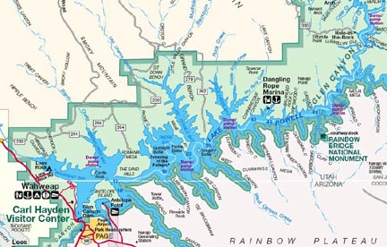
We flew over some of the most spectacular scenery I’ve ever flown over. The lake level is relatively low, but the water is still finding its way into narrow canyons that twist and turn into the sandstone. The rock formations were magnificent; the reddish colors looked incredible against the blue of the water and the partly cloudy sky. It was a bit hazy, making the mountains of Utah look more distant than they really were. But Navajo Mountain was a clearly defined bulk nearby, with snow on the ground among the trees on its north side.

We went quite far uplake, passing Dangling Rope Marina, which is only accessible by boat. I had a map of that area of the lake with me and I consulted it. Sure enough, Rainbow Bridge was nearby. I asked them if they wanted to see it and they didn’t know what it was. I tried to explain, then just took them. They were suitably impressed. The light was shining just right on it and there were no people down there to bother with the noise we made during our short visit.

In fact, the lake was pretty much empty. The high season hasn’t started yet and, on a Thursday, there weren’t many boaters around. We did see a few houseboats already camped for the night, as well as a bunch of campers with tents and powerboats. I’m a bit envious of the people with boats — although I could see much more than they could and explore more of the lake in less time, I couldn’t land, get out, and explore on foot. Boaters have that option.

We went as far upriver as Hole in the Rock, passing the confluence of the San Juan River along the way. Then it was too boring (for them, not me!) and they wanted to go back to where we’d first started shooting photos, in Padre Bay. Finally, they were finished and we headed back to the airport. The dust storm was long gone and, although it looked cloudy to the south and the skies there threatened rain, the weather at the airport was not an issue at all. We landed with 1.7 more hours on the Hobbs.

Next, the Professionals

I took on another 25 gallons of fuel and swapped passengers. Now I was flying the more serious photographers, Mike and his friend Igor. Unfortunately, the sun had slipped below some even thicker clouds and the light was softer than before. It wasn’t bad at the beginning of the flight, but the longer we flew, the worse the light got. It wasn’t late — only about 4:30 PM MST and at least two hours before sunset — but the clouds were ruining the show. I could tell Mike was very disappointed, but there was nothing I could do about it.

Mike was satisfied to simply fly slowly around the area, pausing now and then to manueuver the helicopter so he could take a shot. He and Igor were using professional camera equipment — digital, of course — and Mike spent a lot of time checking each photo in a shaded preview screen before taking his next shot. We covered Padre Bay and headed upriver. Since were were so close to Rainbow Bridge at one point, I took them to see it, but the light was bad by then and the shots wouldn’t have come out very well. They satisfied themselves taking pictures of the slot canyons and the swirls the rocks and water made when viewed from above. Really dramatic stuff. I wished I could shoot photos, too, but both hands and feet were kept quite busy.

Mike and Igor were a funny team. Mike, sitting next to me, would ask Igor a question like, “What do you think, Igor? Where do you want to go?” And Igor just wouldn’t reply. Not at all. Like he hadn’t heard him. At one point, I said, “Igor? Can you hear us?” And he pushed his talk button (I had the voice-activated feature turned off because of the wind in the microphones) and told us he could. But the next time Mike asked a question, it would go unanswered. It was driving Mike nuts and making it difficult for me not to laugh.

Done for the Day

After 1.4 hours, we landed back at the airport. By then, the light was terrible. It was nearly 6 PM and the FBO was scheduled to close. I needed to top off both tanks and retrieve my doors, then make some kind of arrangement for transporation to town, where I planned to spend the night. (I had enough light to get to Grand Canyon or Williams before dark, but the clouds looked thick to the south and I didn’t want to have to turn back. There’s nowhere else to go out there. I didn’t think that dropping in on a Navajo family living 40 miles from pavement would be a good idea.)

Mike and I settled up the bill with his charge card. Although he looked disappointed, he told me that it had been good. I wish it had been better. He spent a lot of money — he had to pay for my round trip ferry costs, too — and if he didn’t get the kind of photos he wanted, it was money down the drain.

Fortunately, the lone FBO guy took pity on me and gave me the keys to the courtesy van for my overnight stay. I had to be back at the airport at 5:30 AM for a 6:00 AM departure to Lake Havasu City.

But that’s another story.

Sunset Over Alamo Lake

I do a custom photo flight at the lake in the middle of nowhere.

The call came on Friday. Could I fly over Alamo Lake for some pictures around sunset?

I asked the logical questions. How many people? Three. Are any of them really big? One big, one medium, one small. Doors on or off? On. Then I told him I couldn’t fly low over the water or anywhere where there were a lot of people. I could get him there and back in about an hour — from Wickenburg. Where was he calling from?

Universal Studios in California, came the surprising answer. But he’d be in Mesa on Saturday and would drive up to Wickenburg. He then proceeded to tell me what he wanted the pictures for and ask a bunch of questions about whether Alamo Lake was a good choice.

“Lake Pleasant is nicer,” I told him. “And closer, too. Alamo Lake is in the middle of nowhere. Not much going on out there.”

“Perfect!”

He agreed to meet me at Wickenburg Airport at 6 PM. It was my understanding that sunset was at about 6:30 in Wickenburg. That would give us plenty of time to get to the lake. The moon would be up and filling out. Even if it started to get dark on the way back, there would be plenty of moonlight for the 30-minute flight over empty desert.

Saturday came. Mike and I decided to take a motorcycle ride up to Prescott. If I get time, I’ll write about that in another blog entry. It was a nice trip. My passenger called at 3 PM while Mike and I were having dessert at a restaurant at the mall. They were on their way. From Mesa.

I’d told him the day before that it was only a 90-minute drive, but I guess he wanted to make sure he got there on time.

I got to the airport at 5 PM. Mike helped me bring the helicopter out and fuel up. I preflighted. My passengers showed up at 5:50 PM. The guy who’d booked the flight, along with his brother and his son. I gave them their prefligtht briefing and we boarded. I was warming up the engine when Mike rode away on his motorcycle. He’d be back in a little over an hour to get me. (My motorcycles live at the airport in the hangar so I had no way to get home.)

I won’t get into details about what the photos were for. Let’s just say that my passenger was writing a work of fiction with an illustrator and needed some photos of what was in his imagination so his illustrator could create the accompanying artwork. He told me a great deal of the plotline as we headed west toward Alamo Lake. He asked a lot of questions, especially about the weather.

He told me he had three data cards for his camera and each of them could take 130 pictures. I wasn’t terribly thrilled with the prospect of flying around Alamo Lake long enough for him to take 390 photos of it. I could spend a lifetime there and not find that much to take pictures of.

As we flew west, the sun was sinking low and the streaks of dirt really showed up on my bubble. It not only embarrassed me, but it kind of pissed me off, since I’d cleaned the bubble while I was waiting for them. I wondered whether my passengers would comment on it (“Don’t you ever clean this thing?”) but they didn’t.

We flew over the lake. My passengers were happy to see it. They started snapping photos. I tried to find one of my stock photos for this piece but couldn’t track one down. Imagine a rather broad valley where three water sources converge: the Big Sandy River, the Santa Maria River, and Date Creek (usually dry). They come together to form the Bill Williams River, which cuts through a canyon as it heads west to join the Colorado River. But Arizona dammed up the mouth of the canyon to form a lake. (Rumor has it that they created the lake to prevent California from getting the water from those three sources.) The lake is roughly round with very few of the flooded canyons that makes Lake Powell or even Lake Pleasant so attractive. Mike and I had camped out there twice and although it was a nice place to get away from it all, there wasn’t much to get away to there.

I remarked at the number of campers in the two main campgrounds. The place seemed packed. They must have had some kind of fishing competition going on. That was the only thing that could ever get that many people out to Alamo Lake. Hell, it was a two hour drive from Wickenburg. Add another hour and a half from Phoenix and you have a long drive. But if you’ve ever been to the Wayside Inn, you know there are fish in that lake.

We flew relatively low to the southwest of the lake and beyond the dam. My passenger wanted to get specific views of the lake and it was my job to deliver him to the exact location where he’d get those shots. I wouldn’t fly low over the lake (no floatation devices on board) or over the campground (no desire to get complaints from the rangers stationed there).

Then we climbed in a spiral over the lake. “As high as you can go,” my passenger told me. I figured that would be about 9000 feet before the vibrations started weirding me out. The lake was at 2000 feet elevation (or thereabouts). The higher we flew, the cooler it got. It started at about 80° by the lake and wound up at about 51° 5000 feet above it. That’s as high as I got. Although the helicopter was behaving nicely, it felt really weird being that high over all that open desert.

The view was bigger up there, although there was a lot of haze. I could see the Bill Williams River winding its way West and the Colorado River and Lake Havasu out there to meet it. I could see the edge of the huge leach field out by Bagdad mine. I could see the mountain ranges lined up in every direction, each range a slightly different shade of color than the one before it. This is the kind of view my passenger wanted, so he was happy. And that’s what counts.

The was one thing that would have made my passenger happier, but it was something I couldn’t provide: clouds. He wanted to see clouds over the lake. But there wasn’t a single cloud in the sky as far as the eye could see. It was a perfectly clear Arizona April day. The kind an east coast girl like me can get sick of when there are too many in a row.

Of course, the higher we got, the higher the sun appeared to get. Sunset was quite a way off at this elevation. I suggested that we descend to hurry things along. My passengers agreed and I started a spiraling descent back down toward the lake. We were about a thousand feet over the lake at 7:00 PM when the sun finally slipped beneath the horizon. It was a typical attractive yet rather boring sunset. A big orange globe sinks. No clouds to turn beautiful colors, no contrails to glow in the sky. The air temperature immediately started to drop.

We headed back to Wickenburg, making one stop to get a shot down the road toward the lake. The darker it go, the higher I flew. It was technically night when I landed at the airport. We’d been up for 1.7 hours, according to the Hobbs meter.

Mike was there waiting for us. My passengers settled up their bill and we went our separate ways.

It had been an interesting flight — mostly because my passengers were city folks from Los Angeles who were unaccustomed to empty desert landscapes. The assignment was interesting, too — not because of what we had to take pictures of but what the pictures were for. It was satisfying to me, as a writer, to see another writer going through the legwork of researching his subject matter. He didn’t just imagine what Alamo Lake was all about based on what he saw on a map or Web site. He’d driven out there once and had gone the extra step (and expense) to fly out there. It was important to him to get it right.

And I was pleased to help him.

Some Good Charters

Flying M Air keeps me busy.

As anyone who runs a service business can tell you, work comes in spurts. You can go days or weeks without any customers, then wham! You’re busy with paying work several days or weeks in a row.

That’s how it is with Flying M Air. The months of January and February were a bit disappointing after a very busy December. But suddenly the phone started ringing again. And in less than 10 days, I had four good charter flights.

Sedona

The first, last week, was to Sedona. I like my Sedona flights. The scenery on the way up there and back (I take two different routes to keep it interesting for myself and my passengers) is beautiful and interesting. My passengers always enjoy the flight, especially if they’re not from Arizona and they’ve never seen its varied terrain. I cruise past the red rocks just enough to satisfy their needs to see them but without straying into the flight path of the helicopter tour company based up there.

At the airport, there’s a restaurant (or at least there is now; it’ll be closing soon) where I can grab a bite to eat while waiting for my passengers to do their thing down in the town. Then I hang out in thec terminal and read or write or chat with the FBO guys or helicopter tour guys or airplane charter guys.

My passengers, in the meantime, go down into the town of Sedona for a Jeep tour or shopping or lunch or any combination of those. They’re usually down there for about 3 hours and I include that waiting time in my price. When they return, I’m ready to go and we head back to our starting point. That’s usually Wickenburg, like it was last week, but I can do the tour from any airport in the Phoenix area. The great thing for the passengers is that they get a wonderful scenic flight lasting 90 to 120 minutes total (depending on where they started from) and they get to “do” Sedona in less than a day. When you’re on vacation based in Phoenix or Scottsdale or Wickenburg, that’s a big deal. My flight saves them the 2-3 hours each way it would take to drive and they still get back to their hotels in time for dinner.

My passengers last week were from Maryland, on vacation in Wickenburg. I set them up with a Jeep tour with the Pink Jeep Tour Company, the big outfit based in Sedona. They had lunch at the airport restaurant before returning to the helicopter for the flight back. They were a nice couple — heck, all my passengers are nice people — and they really enjoyed their day. That’s a bonus for me. And when we landed, they even gave me a tip. Woo-hoo!

Photo Shoot at the Proving Grounds

I’d just left the airport on Wednesday morning, ready to dig into a full day of work at my office, when my cell phone rang. A local contractor was looking for a helicopter to fly a photographer over a job he’d just finished at a local car manufacturer’s proving grounds. Was I available?

I wanted the work, but I wanted to get something done on the WordPress book I’m writing with Miraz. So I told him I was busy until 2 PM and could go then. He said he’d call me back. He did, a while later, and we scheduled the flight for 2.

Keep in mind here that I don’t keep my helicopter out on the ramp, all pre-flighted and ready to go. I keep it in the hangar and normally do most of my preflight work in the hangar (out of the wind or sun) before I drag it out, fuel it up, and park it on the ramp for departure. If everything goes well, I can do all this in about 30 minutes. But I like to allow 45-60 minutes, just in case something doesn’t go smoothly. That meant I needed to be at the airport at 1 PM.

I finished up early and waited for my passengers. They were two men, neither of which had been in a helicopter before. I gave the one with the camera the big option: door on or door off?

“What do most photographers do?” he asked.

“If they’re serious about the photos coming out good, they take the door off. Otherwise, they leave the door on and there’s some reflective glare in some of the photos.”

Door off.

I gave them their preflight briefing and loaded them onboard. Even though they were both pretty good sized men, I put them on the same side of the helicopter. This way, they’d have the same view, which I’d put on their side. It’s nearly impossible to load an R44 out of CG (center of gravity), so I wasn’t worried about that.

One of the passengers had drawn a map of where the proving grounds were. Trouble is, he drew it upside-down, so south was up, and I had to hold it upside down to make sense of it. I thought they wanted the proving grounds just south of Vulture Peak, but it turns out the place they wanted was farther east, near Grand Avenue. We found the place pretty quickly and I settled in for some slow circles around the area at about 500 feet.

There were three objects of the photography shoot. One was a huge skid pad — a big rectangular area, paved smoothly with asphalt. The pad would be filled with water and the cars would skid around on it. Another was a water line that ran from the skid pad to a well. The line was underground, so we expected to just see the disturbed earth over it. We had some trouble finding it because we were told it rand east-west when in fact it ran northeast-southwest right alongside an existing drag strip-like road. The final target was a dirt “hauling road” that ran alongside the edge of the property.

The photographer had a digital camera with 200 shots available and he took dozens of photos. It’s amazing what digital cameras can do. You can take anyone capable of pressing a shutter button, bring him to a place where he needs to take pictures, and let him take 200 shots. Some of them have to be good and a few have to be perfect. It’s just a matter of playing the percentages.

While we flew around and around, the cars below us were taking interest. A lot of the proving grounds in the area have cars that aren’t in production yet. Car magazines use helicopters to get spy photos. (Hey, Motor Trend, I’m available!) So when there are new cars out there, they tend to get under cover when a helicopter flies over. This is taken to a science at some proving grounds.

I pretty much ignored what was going on below me, being more interested in the F-16s that occasionally flew by. I was at the edge of the Luke Air Force Base jet training area and glad those guys had me on radar. But we were the only things flying that day — winds were gusting to 25 knots and all the other pilots were staying on the ground.

When we finished up at the proving grounds, we headed back to Wickenburg to take some photos of various houses and other things in town. We landed and I shut down. The whole job had taken less than an hour.

Grand Canyon

I also do Grand Canyon flights out of Wickenburg and the Phoenix area and I did one on Thursday. Like the Sedona flights, they save the passengers lots of driving time — at least 3 hours each way. But unlike the Sedona flights, the terrain we fly over each way is pretty boring, consisting mostly of high desert, open range with dry grass, stubby trees, and the occaisional group of cows.

I’d flown these passengers before. They were a couple from the Toronto, Canada area and they were very pleasant and well-traveled. The husband was in love with helicopter flight and used helicopters for all kinds of things. The wife was a bit nervous about flying, although not too nervous to let it spoil her trip. I’d taken them to Sedona a few months before and I’m already booked to fly them from Wickenburg to Sky Harbor Airport in Phoenix on Tuesday.

When we got up to the Grand Canyon Airport, the wind was howling and there was snow on the ground. It was cold. I called Papillon, who I’d booked a flight with for my passengers, to get a shuttle to take us from the main terminal to their terminal. It was walking distance, but not exactly close. It turned out that they’d lost my reservation and the long flight I’d booked them for wasn’t being done anymore because of weather on east side of the canyon. The only thing left was the short flight.

I looked across the street at Grand Canyon Helicopters, which is owned by Papillon but flies newer, nicer equipment, and asked the guy to book them on a flight over there. Then we walked over and I waited around until they got on board. I was happy to see them both get front seats next to Ron, a pilot I knew from my Papillon days.

Then, while they took their tour, I went back to Zero-Mike-Lima to retrieve my purse and place a fuel order. I called for a shuttle into the park when I got back to Grand Canyon Helicopters’ terminal. I chatted with the folks there — it’s true, I’ll talk to anyone — and was waiting when their flight returned. They’d enjoyed it and only wished it was longer. I wish it was, too — I know they would have enjoyed the other flight more. But what could we do?

In case you’re wondering why I didn’t take them over the canyon, it’s easy: I can’t. The Grand Canyon airspace is heavily controlled and I’d have to fly over at 10,500 and 11,500 feet (depending on direction). Although my helicopter can fly at 12,000 feet, anything over 9,000 sets up nasty vibrations that I just don’t like. The helicopter tour operators there — Papillon, Grand Canyon Helicopters, and Maverick — have special permits for conducting flights at 7,500 feet. That’s the altitude to fly the canyon. (And if you’re ever at the canyon, take a helicopter tour. It’s costly, but it’s an experience you’re not likely to ever forget.)

The shuttle arrived not long after they returned and it took us into the park. I had him drop us off at El Tovar Hotel, right on the rim. I told my passengers what they could do and see in a few hours. They invited me to join them for lunch and I agreed. We had a nice lunch at El Tovar, then split up. They walked down the rim path toward Bright Angel Lodge. I hung around El Tovar’s lobby for a while, then went out for a short walk. I was back in the lobby when they returned.

Grand Canyon in March

The Grand Canyon right after a snowfall.

They’d had a nice walk and had stopped into a few shops, including Hopi House, and the Fred Harvey museum in Bright Angel Lodge. We took the shuttle back to the airport. It took a long time to warm up the helicopter in the wind, which was now gusting to 22 knots, but we finally had the engine warmed up enough to depart. I was the only pilot on the radio. We took off to the south. I showed them our Howard Mesa property on the way, skirted around a controlled burn in Williams, and flew directly back to Wickenburg. It wasn’t an exciting flight but we were lucky that the wind was mostly out of the west, so it didn’t slow us down too much. We were back at the airport by 4:30 PM.

Golf Course Photo Shoot

The call came as Mike and I were preparing to go out to dinner on Thursday night. The woman was uncertain, as if she thought she was on a mission she’d never accomplish. Did I have a helicopter available to take a photographer around a golf course in Peoria the next day?

I saw another day of WordPress book work slipping away. “What time?” I asked.

“About ten?”

I told her I could do it and she gave me her contact information. She said the photographer might call to finalize the pick up location. She wanted me to land on the golf course, but didn’t have GPS coordinates for the landing zone and I’d never seen the golf course from the air — I usually don’t fly over there.

The photographer called a while later. She asked if we could do it earlier, like around 9:30. I told her we could. We talked some more. She said she wanted to get an early start, like maybe around 9 AM. I told her that was fine. We talked some more. She said she liked working early in the morning. Could I come earlier?

“What time do you want me?” I asked. I had already crossed out the time twice on the calendar and it was beginning to look pretty messy.

“Well how about around 8 AM? Or maybe a quarter to eight?”

“Seven forty-five?” I asked.

“Well, yes,” she said almost uncertainly. “Around a quarter to eight.” She made it sound as if that was a different time than seven forty-five.

We agreed to meet at Turf Soaring School, a small private airport that caters to gliders and ultralights. It should be easy for her to find and it should be near the golf course.

I got to the airport at 6:30 AM the next morning and pulled my helicopter out just as it was getting light. There was a big cloud on the horizon and the sun poked through it long enough to turn its edges golden. I wondered if the cloud would ruin her photos.

I fueled up, started up, warmed up, and took off. It was a quick flight, less than 20 minutes. I flew under that cloud I’d seen — evidently, it was a lot lower and smaller than it looked — and there was nothing but clear skies ahead. I landed at Turf, shut down, listened to a voicemail message on my cell phone from the photographer, and got out. I was just removing the front passenger door when the photographer drove up on the cross runway. I don’t think she realized it was a runway. It was dirt and not very well maintained.

We introduced ourselves and I told her where to park. Then I walked over and waited while she reformatted some cards for her digital camera. She had a huge bag of photographic equipment, almost all Nikon stuff. She told me how she’d gotten it cheap (or maybe for free) and dropped a few names of celebrities. Name dropping normally turns me off, but I wasn’t bothered too much. It was probably standard procedure in the circles she moved in. Not having other names to drop back, I kept quiet. (Really.)

We took off. The golf course was literally 5 minutes away. What followed was about a half hour of out of ground effect (OGE) hovering all over the golf course. Fortunately, houses hadn’t been built there yet, so I wasn’t endangering anyone on the ground. At one point, however, we moved close to the neighboring development of Trilogy and I saw people coming out of their homes to watch. I wondered whether the FAA would be calling later with complaints. I had nothing to worry about — I wasn’t hovering over anyone’s house — but people tend to exaggerate things to make their cases stronger when complaining.

It was a challenging flight for me. Lots of OGE hovering with a tail wind. But Zero-Mike-Lima and I were up to the challenge. That helicopter has all the power in the world with just two people on board. A few times, right after getting into a hover in the right spot, the wind would kick us from behind. I’d kick back with the pedals and get us stablized quickly.

The photograher, at one point, said, “You’re a great pilot.” At first, I thought she was just saying that to make me feel good. After all, who was I? Some Wickenburg-based pilot who didn’t even have any names to drop in a name-dropping conversation. But when she said it again and again, I started to think she might mean it. She did this kind of work with helicopter pilots all over the world. Although I don’t think I was the best, it was good to know I wasn’t the worst. In other words, I didn’t stink.

The golf course, by the way, was beautiful. Although I hate the idea of tearing up the natural desert to plant grass that soaks up our most precious resource here — water — I do admit that these desert golf course designers make glorious landscapes. This was one of the nicest I’d ever seen.

We finished up and flew back to Turf. The photographer told me that from now on, when she did aerial photography in Arizona, she’d use me. Of course, she lives in Monterey, CA, so I don’t know how often that would be. Better not quit my day job.

The Feast

That was the recent feast in my feast or famine cycle. With another two flights already scheduled for Tuesday, it has the potential to continue for a while. I hope so. Summer is dead time here and I’m not sure if that cherry drying gig will work out.