Our normally invisible river shows its ugly side.
“A house hit the bridge.”I heard this unusual comment while visiting a friend’s booth at the art fair at the library yesterday. It seemed that the Hassayampa River, which has been running for about two months now, had reached flood stage. And as usually happens to flooded rivers, it had altered its course a bit. As a result, its muddy waters had attacked Jack Burden Road, which runs along the east side of the river. A trailer park there was in serious trouble.
Mike and I walked to the bridge to have a look. There were already hundreds of people there. Although the bridge had been closed for a while so the police could determine whether the bridge had been damaged when the house hit it, it was now fully open. Cars moved slowly in both directions and people crowded the upstream side, waiting for the next house to float by.
There was no next house — at least not while we were there. But there was a lot of activity on the far side of the bridge, where Jack Burden Road was. I didn’t remember the houses being so close to the water. And I could swear there had been more trees in the area.
We ran into Ray, who was watching the festivities with his wife. Ray had been flying earlier in the day. For that matter, so had I. I’d gotten a call from a woman named Kathy who told me she needed a helicopter to “rescue” Marshall Trimble, the Arizona State Historian. Mr. Trimble was stranded at the Kay El Bar Ranch, which was cut off from the world by the Hassayampa on one side and Martinez Wash on the other. He was supposed to be the Grand Marshall of the Gold Rush Days parade they had in town that day, but when I got the call, the parade was just about over. (You’d think someone in town would have suggested me a bit sooner.) I told Kathy that Ray was already in the air and that she should call the airport and have them use the radio to talk to him. I was downtown and it would take at least 45 minutes to get back to the airport and launch.
I called her back ten minutes later to make sure she’d reached Ray. She hadn’t. And she seemed very concerned. Mr. Trimble had an engagement in Phoenix that evening and would miss it. So I arranged to have her drive me to the airport — Mike had wandered off on horseback with a friend and his truck keys. She took me in her Miata, which was even dirtier inside than my Jeep, and accompanied me while I pulled Zero-Mike-Lima out of its hangar and onto the ramp. Then she climbed aboard and I started up. While the engine warmed up, she told me stories about her days as a helicopter news reporter. Then we launched and headed northeast for the 2-minute flight to Kay El Bar.
She told me that there was a helipad a half mile west of the ranch. I’ve been flying around Wickenburg for more than four years now and I didn’t remember seeing any helipad near Kay El Bar. She also told me that Mr. Trimble would be riding a horse to the helipad. Okay. We reached the ranch and looked around. There were some people gathered near one side of a house pad — a cleared and level piece of land that is being prepared for construction. Grantham Ranch is a housing development that’s just starting to be built in that area. This particular house pad overlooked the ranch and the river. And, as we began to circle, I saw two horses heading up what would someday be a driveway. I began my descent. A few moments later, I was on the ground and two men — one of them wearing chaps — were coming toward me.
I instructed Kathy to tell them not to walk behind the helicopter. She got out while I sat at the controls with the engine idling. They loaded an overnight bag, soft briefcase, and guitar into the back of the helicopter. Then Mr. Trimble — the man without the chaps — got in and buckled up. The cowboy moved away, I spun up, and after a quick look around, took off.
 I could have hurried right back the airport, but since none of us were in any rush, I figured I’d take the opportunity to check out the river. We flew past Kay El Bar, which had water right up to its front lawn, and headed up the river. A number of ranches had some water flowing through their low spots. I watched some cattle cross a stream. But the most dramatic scene was at the narrow slow canyon north of town — the water was squeezing through the slot and had reached a depth of at least 20 feet. There would be no driving through the slot anytime soon.
I turned and headed back down the river. We swung out over where the carnival was, then headed back to the airport. I landed and shut down. I let my two passengers go back to town in the Miata, figuring I’d get a ride back with Mike. I think they had trouble getting the guitar in there. A while later, I was back at the art fair with Mike and Zero-Mike-Lima was in its hangar.
We’d had lunch there and had been walking around for at least an hour when I heard the comment about the house and we went to the bridge to check it out. I hadn’t noticed anything during my flight, but I admit that I don’t exactly study the ground while I’m flying. When we ran into Ray, I told him that we should go up and see if we could find that house. I was joking at the time, but after a while, it sounded like a good idea. A bit more interesting than the art show and carnival, anyway. So Mike and I went home to get a camera, then headed back to the airport. We pulled Zero-Mike-Lima out again and parked it on the ramp, facing into the wind. The wind was coming from the southwest and was blowing pretty good. The sky was filled with an amazing variety of clouds, from rain-dumping clouds out to the north to big, puffy clouds to the west and southwest. The ceilings were still high enough for safe flight, so I started up, warmed up, and took off.
Don from LifeNet made a radio call when he was six miles out. He was returning from the valley to Wickenburg Airport, where he’d refuel before parking at the hospital. I made a call so he’d know where I was.
“I didn’t know you could fly those in the rain,” he teased me.
“Sure I can,” I replied. “How do you think I get the bugs off the windscreen?”
“Well, I told you what’ll happen if you keep watering it.” His joke was that my R22 had turned into an R44 (which is bigger) because I’d watered it.
“Yeah,” I replied. “I figure that if I fly it in the rain enough, I might be able to turn it into a Sikorsky S92.” An S92 is a very big helicopter.
“There you go!” he laughed.
 We flew over town and circled the area around the bridge. Mike got some excellent photos of the damage on Jack Burden Road — which you really couldn’t see from the ground — and the carnival right across the river. Then we headed up the river so I could show Mike how full the slot canyon was. It was raining up there, so I turned around and headed back down the river, in search of what was left of the house that had gone downstream. We hit a pretty nasty downdraft just past the bridge and since neither of us liked that, I climbed an extra 200 feet. It was a good thing I did, because when we got to the Morristown area, a helicopter flew under us, going up river. I don’t even know if he saw us. I turned around and followed him upriver, keeping some distance between us. At about that time, Don from LifeNet made a call for his departure from the airport. A moment later, I heard him on the radio again, asking the helicopter over town if it was on frequency. Although I expected the helicopter ahead of me to answer, it was Ray who replied. That meant there were four helicopters operating over town at the same time.
It turned out that the helicopter who’d passed me was from Channel 5 TV. Ray told me as I neared downtown and he was heading down the river. Channel 5 wasn’t on the local airport frequency (123.0), but I found them on the helicopter air-to-air frequency (123.025). They were in a high hover just north of the bridge when I flew past to the west. We headed up Martinez Wash, past Scenic Loop and over Ray’s quarry. Then back down the river. Mike took lots of pictures. Ray moved out toward Constellation Road, Channel 5 went back to Phoenix, and we flew south to Morristown again, then west. I flew over the top of Vulture Peak, then down to Vulture Mine, where a lot of dirt bike riders were gathered for some kind of event. Finally, we headed back to the airport.
We hadn’t found the house. Chances are, it had broken into a million pieces when it hit the bridge.
After seeing the river’s fury today, I’m amazed that the Arizona Department of Transportation would even consider adding another bridge and/or a roadway on its banks. Jack Burden Road may not have been built with today’s technology, but it certainly provides a good example of how the power of water can destroy what man builds.
 I could have hurried right back the airport, but since none of us were in any rush, I figured I’d take the opportunity to check out the river. We flew past Kay El Bar, which had water right up to its front lawn, and headed up the river. A number of ranches had some water flowing through their low spots. I watched some cattle cross a stream. But the most dramatic scene was at the narrow slow canyon north of town — the water was squeezing through the slot and had reached a depth of at least 20 feet. There would be no driving through the slot anytime soon.
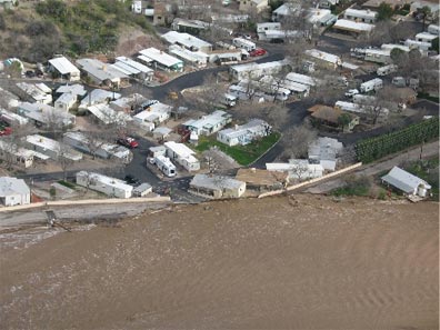 We flew over town and circled the area around the bridge. Mike got some excellent photos of the damage on Jack Burden Road — which you really couldn’t see from the ground — and the carnival right across the river. Then we headed up the river so I could show Mike how full the slot canyon was. It was raining up there, so I turned around and headed back down the river, in search of what was left of the house that had gone downstream. We hit a pretty nasty downdraft just past the bridge and since neither of us liked that, I climbed an extra 200 feet. It was a good thing I did, because when we got to the Morristown area, a helicopter flew under us, going up river. I don’t even know if he saw us. I turned around and followed him upriver, keeping some distance between us. At about that time, Don from LifeNet made a call for his departure from the airport. A moment later, I heard him on the radio again, asking the helicopter over town if it was on frequency. Although I expected the helicopter ahead of me to answer, it was Ray who replied. That meant there were four helicopters operating over town at the same time.
 Of course, now that the rain has let up to a drizzle, the water’s flow is receding. An hour has gone by since I woke up and the flow is now no more than a narrow stream of brown water. An hour ago, it would have been impossible to leave the house; my driveway was under two feet of running water in some places. Now, I could drive — or even walk — across. A few years ago, I was home alone when a big storm hit. The wash filled with water, all the way across, to a depth of at least four feet. We had some trailers parked in the wash and one of them — a 12-foot flatbed — was washed a mile downstream (see photo). It took a back-hoe to get it out of the ground. The other trailer, a 3500-lb 2-horse horse trailer, was slowly washed about 150 yards downstream. Thank heaven it didn’t get washed over on its side. As it was, we had to replace all wheel bearings in both trailers before we could use them again.