
An example of geometry in construction.
We finished up our recent Alaska vacation with a few days in the Seattle area, visiting Mike’s cousin Rick. Rick took us on an overnight trip out to the islands northwest of Seattle. Although we initially got on the wrong ferry (and wound up on the wrong island) we eventually made it to our destination on Whidbey Island.
Along the way, we stopped at Deception Pass. This is a narrow straight of water with an extremely fast current during tide movements. According to Wikipedia, which has separate entries on Deception Pass and the Deception Pass Bridge:
In the spring of 1792, Joseph Whidbey, master of the HMS Discovery and Captain Vancouver’s chief navigator, sailed through the narrow passage that is now called Deception Pass and proved that it was not really a small bay as charted by the Spaniards (hence the name “Deception”), but a deep and turbulent channel that connects the Strait of Juan de Fuca with the Saratoga Passage, which separates the mainland from what they believed was a peninsula (actually Fidalgo Island and Whidbey Island).
 The Deception Pass Bridge crosses over this strait, about 180 feet above the water (depending on the tide). There are actually two spans to the bridge with a small uninhabited island between them. There’s limited parking on both ends of the bridge with plenty of places to stop and take in the view.
 The bridge includes a 3-foot wide sidewalk on each side, which is definitely not recommended for those who are afraid of heights. We walked across on one side and back on the other. To prevent people from crossing the relatively busy roadway, a flight of stairs leads to a pathway under the bridge on either bank. That’s where I took this photo. I liked the symmetry of the construction and the fact that I could frame the photo in such a way that the pattern seemed to go on forever. This is a theme I try to capture in my photos when I can: infinity.
There were kayakers down on the water, braving the strong current. And lots of people walking around in the vicinity of the bridge. If you’re ever in the area, sop by and check it out.
 The full-frame version of this photo is available for sale as cards and prints at RedBubble.com.
 In May 2006, a
 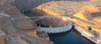 Last year my husband Mike came along for the ferry flight to Page. We stayed two nights — I fly only around sunrise and late afternoon for my clients on this gig — and departed early the next morning for Wickenburg. That’s when Mike took this shot of the Glen Canyon Dam with the morning sun casting shadows in the canyon.
 The lake is highly controversial. The dam flooded a huge area of pristine canyon lands with many archeological sites and even a few active settlements. This land was mostly inaccessible, like so much of America’s desert wilderness. That may be why the decision to build the dam was made. Although the Sierra Club would like nothing more than to destroy the dam and drain the lake, at this point I think it’s too late. The canyon walls are stained with minerals from the water and all plant life beneath the current water level is dead. It would take hundreds, if not thousands, of years for the area to be restored to its original health and beauty. Sadly, the need for water in the desert southwest has become more important than the need for another remote wilderness. We should be thankful that the original plan to stretch a dam across the Grand Canyon was scrapped, as we could have lost that instead.
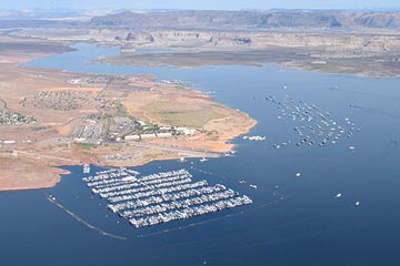 I think we should be satisfied with the beauty of the lake and the recreational opportunities it provides. Although most boating activity goes on in the Page area, there’s nothing so peaceful or relaxing as climbing aboard a houseboat for a week-long trip up lake, where few day-trippers venture. Exploring the side canyons by small boat or on foot gives you a sense of what it might have been like before the waters rose.
 This case of cakes and pies and pastries called to me. In Arizona real bakeries are a rarity. Supermarkets here are big and new and almost all of them have a bakery department. Some are actually quite good. Our recently renovated Safeway here in Wickenburg has a nice display case of cakes and cookies these days. But I’ve never seen any bakery in Arizona with a display like this. And I’ve never been to a bakery in Arizona worth writing about.