Any excuse to fly, eh?
I’m currently based in the Sacramento area of California for my late winter/early spring job as a frost control pilot. I live part-time in a nice farm town I’ve grown to know and like over the past four years, waiting for the weather to turn cold and a phone call telling me to get ready to fly. At that point, “passive standby,” when I get paid by the day to have my helicopter on-site, turns into “active standby,” when I get paid by the hour to wait. When the fly call comes, I theoretically spring into action, firing up the helicopter and heading out over my almond orchards to circulate air and keep the frost from damaging the developing nuts.
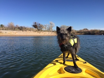
I say “theoretically” because although this is my fourth year as a frost pilot, that fly call has never come. Instead, each season I wind up being paid by the flight to fly to California, being paid by the day to hang around in very pleasant weather doing whatever I like while it’s still kind of dreary at home, occasionally being paid by the hour to sit in my truck at the airport at night waiting for a fly call, and eventually being paid by the flight to fly the helicopter home. I earn enough in two months to carry me financially until cherry season starts in May — and beyond. Along the way, I have a grand old time in Northern California’s Central Valley. I’ve made some friends, done a ton of hiking, gone wine tasting, kayaked the American River and Lake Solano, learned to fly a gyro, gone ballooning, and even given my bees an early start to the spring season. In general, it’s just an extension of my winter travels, with lots of flexibility to go where I like and do what I want — as long as I can get back to base by midnight when I’m put on active standby.
Anyway, my point is that I don’t have a lot of flying to do for this job. So instead, I take the helicopter out on “maintenance flights.” This is where I start up the helicopter to make sure it’ll start when I need it and since I’ve got the engine running, I may as well take off and since I’m taking off, I may as well go somewhere interesting like up Cache Creek or into Napa Valley or around Sutter Butte.
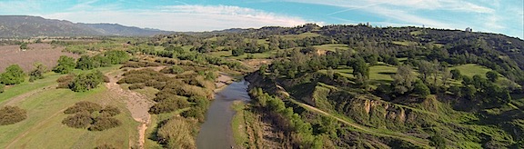
My favorite “maintenance flight”? Low-level up Cache Creek, especially just after dawn.
Yesterday’s Excuse for Flying
My helicopter is coming up for overhaul soon and I’ve begun interviewing service centers to find one that’ll do the job the way I want it done at a price I’m willing to pay. I’ve already visited a shop in St. Augustine, FL, and have talked to the folks in Hillsboro, OR, who sold me my helicopter nearly twelve years ago. (Hard to believe it’s been that long, eh?) I’ve recently gotten more motivated to learn my overhaul options; one of the magazines I write for has agreed to a 1000-word article about my search for a shop. So I obviously need to visit more shops.
So the other day, I checked the Dealer/Service Center page on Robinson Helicopter’s Website. And I made a list of the centers in Northern California. And I started making calls. By the end of the day, I’d made plans to visit the folks at Airmotive Specialties, the service center in Salinas.
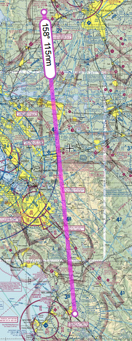
The direct route to Salinas was easy enough.
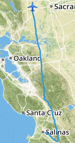
I was not interested in driving to Salinas. The 170-mile drive would take at least 3 hours each way. Obviously, I’d fly. Foreflight told me it would take about an hour and 20 minutes and that was fine with me. (I have 200 hour to burn off on the helicopter before November.) A review of the direct route showed that it was pretty easy, with no serious concerns about airspace or mountain terrain. Weather was forecasted to be good on Wednesday, although rain was moving in north and east of San Francisco (where I’m based) later in the week. It was a no-brainer. I made tentative plans to fly on Wednesday afternoon.
The Flight Down
I spent Wednesday morning taking care of odds and ends: writing a blog post, updating a friend’s website, answering email messages, scanning receipts, walking to the closest RedBox to drop off a video and pick up another one. The man I needed to meet at Airmotive would be at the office all day, so there was no rush. I had lunch just after noon, then climbed into the truck with Penny and headed out to the airport. A while later, after setting up my GoPro “nosecam,” iPad with Foreflight, and phone for music, I fired up the engine. I was heading south by 1:30 PM with Penny lounging on her bed in the front passenger seat beside me.
It was an uneventful flight. Well, mostly.
I think a sidebar is in order to explain why I didn’t fly right through Livermore’s airspace and talk to the tower.
First of all, my direct route would have put me less than 1/2 mile into Livermore’s airspace — nowhere near the runway or tower. It wasn’t a big deal to adjust course a tiny bit to the left (east) to avoid it.
Second, my experience with towered airports has been a real mixed bag over the 15+ years I’ve been flying. If an airspace is directly on my flight path, I’ll ask the controller to transition. I might make a request like “Helicopter six-three-zero-mike-lima, 10 miles northeast, would like to transition southbound on the east side of your airspace.” (That’s what I might have said on Wednesday to Livermore.)
About half the time, the tower will allow me to “proceed as requested,” sometimes asking me to “ident” (push a button on my transponder which momentarily makes me more visible on his radar) or even assigning me a squawk code (an unique 4-digit code for my aircraft on radar). All that’s quite reasonable and fine with me.
But other times, the tower will require me to follow a certain route through the airspace — for example, over the top of the airport, midfield at a specified altitude. This can waste time and fuel. And still other times, the tower will instruct me to climb to an altitude above the airspace — usually 2500 feet AGL or higher — to “transition.” (Technically, this is not transitioning the airspace because I’m technically not in it when I’m flying that high over it.) This is nosebleed territory for helicopter pilots who typically fly 500-1000 feet AGL, not to mention a real waste of time and fuel. And other times — admittedly rarely — the tower will simply deny the request and tell me to stay clear. (Scottsdale liked to do this.)
So the solution I’ve come up with is this: if my direct route doesn’t take me within two miles of the runways or tower, I adjust my path to fly around the airspace and monitor the tower frequency to listen for traffic. At my altitude, airplane traffic — other than crop-dusters — is seldom an issue.
There was a close call with a biplane crop duster who apparently didn’t see me where I was cruising at about 1000 feet AGL (Above Ground Level) just to avoid crop-dusters. I guess he was going back to base. I dumped the collective and dropped down to about 300 AGL quickly while taking other evasive actions. He passed above and behind me and I continued on my way, climbing back up to at least 700 AGL and keeping a sharp eye out for others.
And then near Livermore, another traffic situation. I’d tuned into Livermore’s tower to monitor the frequency as I flew southbound just east of the tower-controlled airspace. I heard the controller warn another pilot about traffic that sounded just like me. I stayed quiet until the controller came back on the radio about a minute later, sounding a bit alarmed that the traffic (me) was only a half-mile away. I looked up and left and saw the Cessna flying at least 500 feet above me, westbound. I keyed the mic button and said: “Livermore Tower, helicopter six-three-zero-mike-lima, just east of your airspace, has that airplane traffic in sight. I’m passing below him, no factor.” The controller sounded more than a little relieved when he responded with thanks.
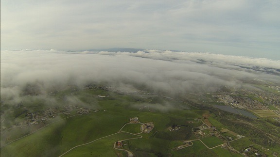
You can see the marine layer moving in on the right side of this shot. I was about 5 miles from Salinas Airport here.
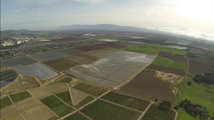
I was in the mountains, abeam San Jose Airport, when I started noticing the marine layer moving in from the west. I fiddled with Foreflight’s settings to get visibility information for the nearby airports. All of the ones in my vicinity — including Watsonville and Salinas up ahead — were reporting 10 miles or more. But I didn’t like the way those low clouds look. I know from experience that the marine layer can turn an airport from VFR to IFR in fifteen minutes when it’s moving just right.
I landed at Salinas and followed the controller’s directions to “the biggest hangar on the field.” I parked in an empty airplane tie-down spot nearby. As I shut down, I looked at the windsock and the low clouds. The wind was clearly pushing the marine layer in from the west. I might not have much time if I wanted to get back that day.
At Salinas
My meeting went extraordinarily well. I met the boss, had a quick tour of their facility, and chatted with him about my options. He and his crew have done more than a few Robinson overhauls, including one for a helicopter that was parked right outside his hangar door. He’d learned a few things that would save me money while keeping me safe and in full compliance with FAA requirements. He had local sources for aircraft painting, upholstery, and parts inspections. Best of all, he could get the work done within my stated time restraints — I would need it back by mid February for next year’s frost season.
He and his helicopter guy came out and looked at my ship. They said it looked good — I have to wonder if they say that to everyone or if so many other ships don’t look good that they feel compelled to say something when they see one that looks better than usual. I have to agree that it doesn’t look 11+ years old. I’ve taken very good care of it over the years, getting quality maintenance done by good shops and keeping it in a hangar (or garage) for most of its life.
My visit ended by giving him my complete contact information so he could work up a quote. I’d have to order the overhaul “kit” from Robinson at least six months in advance to get it in time. Clearly, I’d need to choose a shop a lot sooner than I expected to, possibly as early as May 1.
By the time I got outside, it was overcast and downright cold. The marine layer had indeed moved in, with clouds just 1200 feet above the field (according to the ATIS recording) and mountain obscuration to the north, where I needed to go. It looked as if the only clear routes were to the south. I’d need to fly around the weather to move north.
But first I needed fuel. I’d burned half of what was on board on my trip down and did not want to go into any weather situation without full tanks. A call on the unicom frequency got me nowhere, so I walked over to the general aviation terminal and found someone in the Airport Manager’s office who gave me a phone number to call for fuel. While I waited for the truck, I fiddled with Foreflight to get additional weather information. But I didn’t need a computer or weather report to see that I wasn’t going to be taking the direct route back.
Around this time, I realized that I’d forgotten to text a Facebook friend who worked at the airport. She’s a medevac pilot who was on duty that evening. I was supposed to text her when I arrived so she could drop by. But the incoming marine layer had distracted me and I’d forgotten. Now, with the weather getting worse by the minute, I couldn’t wait around. I texted her my apologies. Another time? Chances are, I’d be back in November; I’d very much liked what I’d seen and heard at Airmotive.
The Flight Back
My actual track, as logged by Foreflight, on my return flight from Salinas. Talk about circumventing weather!
Once the fuel was on board and I’d added some oil, I climbed back on board and started up. The ATIS mentioned ILS approaches but the airport was still VFR. I asked for a departure to the east, got clearance, and took off.
I had my GoPro “nosecam” running for the whole flight. With the sun behind me — if it made an appearance — I knew the light would be much better than it had been on the way down. (I don’t record every minute of every flight. I already have too much mediocre footage; now I just try to get good footage.) The camera captured the situation well: very low clouds for quite a distance. I aimed for some brightness on the horizon, stayed at an altitude that kept me below the cloud layer, kept a sharp eye out for towers, and flew southeast.
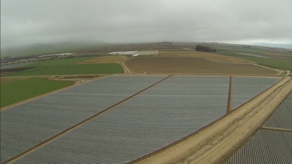
I really wanted to steer left in this shot, taken less than a mile from the airport. But instead I aimed for that bright spot in the far right — southeast bound.
Don’t get me wrong. I could have tried scud running a path up the valley to the north. And I might have found a comfortable way to get where I wanted to go. But I’ve run scud enough times and have found my way blocked enough times that I’ve learned not to even bother trying if there’s an easy way around it. I know marine layers well enough to know that they don’t usually cross mountains. If I could get to the far side of the mountains east of the airport, I’d find a clear way north.
And that’s exactly what happened. I aimed for the brightness, which got bigger and brighter the farther I went. Suddenly, I was in sunlight, climbing the bright green foothills of the mountains on a northeast heading. Soon I was at cloud level just to the east of the clouds heading due north. Before long, I was above the marine layer, looking out at islands of mountaintops in the clouds to the west.
Only six minutes passed from the time the previous photo was snapped to the time this one was snapped. At this point, I was banking to the northeast, climbing above the marine layer just east of where it got “stuck” in the mountains.
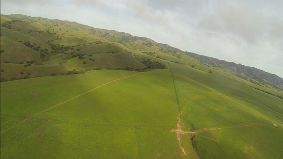
I adjusted my course on both my helicopter’s Garmin 430 GPS and Foreflight and attempted to fly direct back to my base. The lush green hills were amazingly beautiful and the shadows from the sun shining through the marine layer gave them an extra depth. It was hard not to detour in a few places to get some better views. I let the camera run, figuring I’d get a few good shots along the way.
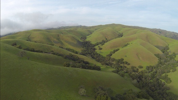
California’s hillsides are gorgeous in the spring. You can see the marine layer trying — but not succeeding — to climb over the hills on the left.
I flew for a while to the east of the marine layer, but as I crossed the valley near Hollister, the marine layer moved in beneath me. I was already about 2500 feet up, having just crossed some mountains, and knew I’d have to cross more mountains on the other side of the valley, so I stayed at altitude and crossed above them, with glimpses of the farm town beneath me. The air up above the clouds was a bit rough and we got bounced around a bit. So the next time I had the option of flying above or below the marine layer — near Livermore — I elected to fly below it. That had me flying just below the clouds along a hillside east of the airport there, almost on my original flight path down.
I flew above the marine layer clouds at Hollister and was rewarded with a bumpy ride.
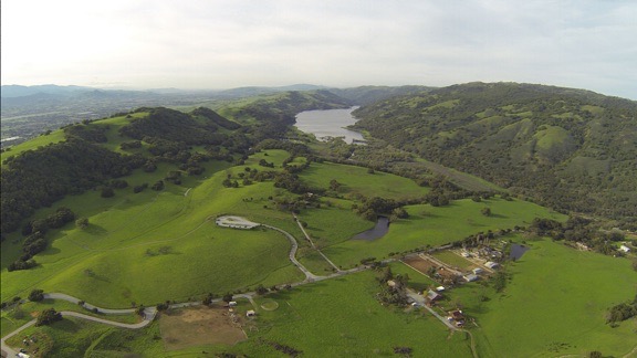
I couldn’t resist flying down this lake-filled valley east of San Martin.
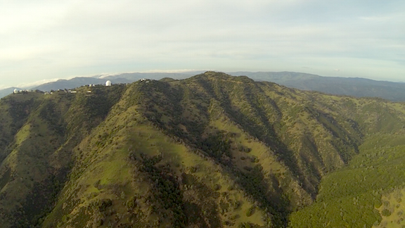
While I didn’t overfly any of the buildings at Lick Observatory, I did fly close enough to get a good look. (Hope I didn’t wake anyone!)
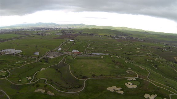
I was over this Livermore area golf course at 4:39 PM when one of my Twitter friends saw me fly by.
The rest of the flight was pretty uneventful. I made a straight line back to my base, over two wind farms, a handful of small cities, the Sacramento River, wetlands, and lots of farmland. It was just after 5 PM when I set down on my grassy parking spot at the airport.
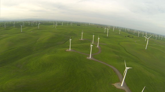
Windmills that had been still on my way south were turning by the time I flew back north.
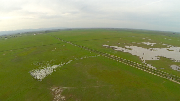
All of the wetlands in northern California are full of these large white birds that take flight as soon as they hear a helicopter approaching. This was a big flock — yes, every white dot here is a bird. Fortunately, they stay very close to the ground.
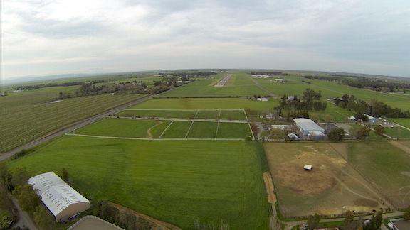
On final approach to this year’s base of operations west of Sacramento.
I gathered together my things, let Penny out to run on the grass, and locked up the helicopter. I chatted for a while with one of the line guys about the upcoming rainy weather and placed a fuel order. (The helicopter must always be topped off with fuel when I’m on call.) Then Penny and I headed back to the truck and our temporary home.
I’d logged a total of 2.7 hours of flight time.
@mlanger
Golfing at Wente in Livermore and see this Red R44 streaking by on a NW track 4:30pm. I said could it be ML???— Steven Pass (@PassSteven) March 3, 2016
Later, after I drove back to where I’m staying and relaxed for a while, I checked in with Twitter. I found a tweet from one of my twitter friends who had apparently seen me from the ground while he was golfing in Livermore. How’s that for small world syndrome?
It had been a good flight and a nice day out and about. Although I could have done without the detour — which probably added 20 minutes of flight time to my return trip — I certainly couldn’t complain about the views along the way.