An Insider’s Look at Helicopter Spray Operations

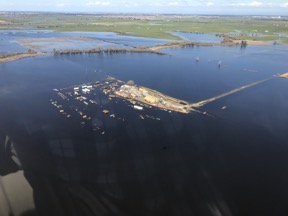
Fascinating work with a lot of very specialized equipment.

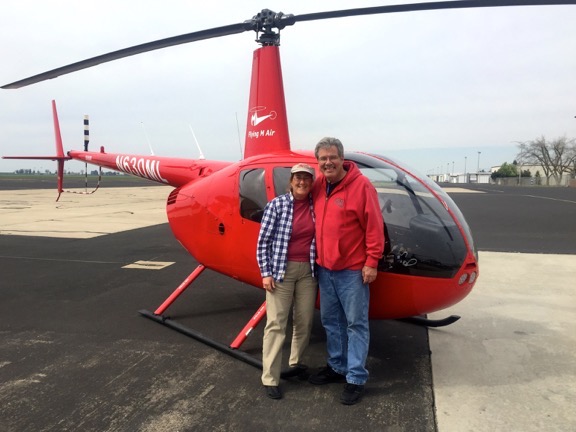
My friend Sean runs a helicopter spraying operation. (You might know about this kind of work by another name: crop dusting.) The business is highly regulated not only by the FAA to ensure that operators and pilots have the skills and knowledge to do the work safely from an aviation perspective, but also by state and local agencies concerned with the safety of the chemicals being sprayed. It also requires a ton of very costly specialized equipment, from spray rigs that are semi-permanently installed on the helicopter to navigation equipment that helps the pilot ensure chemicals are spread evenly over crops to mixing and loading equipment to get the chemicals into the helicopter’s spray tanks.

Sean's Helicopter with Spray Gear
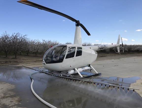
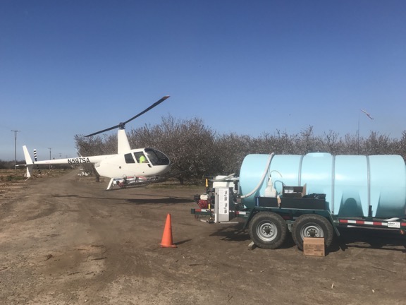
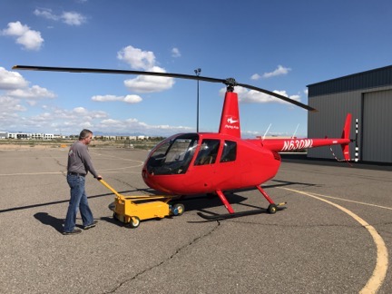
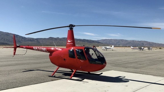
Sean’s helicopter with spray gear. He was running rinse water through the system on the ground here.

A lot of people have asked me why I don’t go into this business. Although I’d love to fly spray jobs, I have absolutely no desire to invest in the required equipment, start selling spray services to potential clients, or deal with the government agencies that need to get involved for each job. Or have employees again.

Sean is just getting his business off the ground (no pun intended) after over a year of spending money on equipment and jumping through hoops with the FAA. While I wouldn’t say he’s struggling, he’s certainly motivated to complete contracts and collect revenue. Unfortunately, it’s not the kind of work a pilot can do cost effectively without help. He needs at least one person on the ground to mix and load chemicals, refuel the helicopter, and keep the landing zone secure.

Sean was having trouble finding someone to do the job. It’s not because he isn’t paying — I think he’s paying pretty good. Trouble is, a lot of folks either (1) don’t want a job that doesn’t guarantee a certain number of hours a week or (2) don’t like physical labor. Because the job depends on when there’s a contract to fulfill and what the weather is like when the job needs doing, hours are irregular. And it is tough physical work.

Spray Gal
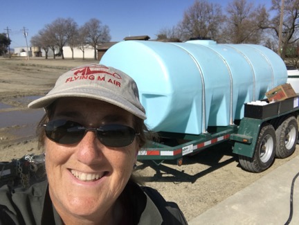
Here I am in my coveralls, hamming it up for a selfie between loads.

I know because I stepped up to the plate to help him with his first two big jobs. I thought I’d spend a bit of time talking about this work from the loader’s point of view.

The Job

The pilot’s responsibilities are to spread the loaded chemicals over the crops to be sprayed using the tools in and on the helicopter. I can’t speak much about that because I haven’t flown a spraying mission. I can tell you that in a light helicopter like the Robinson R44, the pilot is doing a lot of very short runs — sometimes only a few minutes — and is often spending more time getting to and from the spray area than actually applying the spray. For that reason, the landing/loading area needs to be as close to the crops as possible — usually somewhere on the same property. The pilot is taking off near max gross weight for most flights and landing relatively light. And there are a lot of take offs and set downs. As I told Sean the other day, doing spray runs is a lot like doing hop rides at fairs and airport events — you just don’t need to talk to your passengers.

The loader’s responsibilities — well, that’s something I can address since I’ve been wearing that hat for the past two weeks.

When the pilot is warming up the aircraft for the first flight of the day, the loader is mixing the first batch of chemicals. Sean’s current setup includes a mix trailer that holds 1600 gallons of fresh water, a Honda pump, a mix vat, and a dry mix box. With the pump running, I turn valves to add 50 gallons of water to the vat, which is constantly mixing. Then I add about 4-6 capfuls of an anti-foam agent (which is not HazMat) to the vat, followed by a specific amount of chemical provided in 32-ounce bottles.

Mix trailer
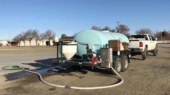
Sean’s mix trailer onsite at an orchard near Woodland, CA. This is the “business end.” The mix vat is on the left.

Luna Sensation
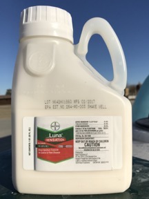
This is how the chemical we’re using is shipped: in 32-ounce bottles.

The chemical we’ve been using is a “broad spectrum fungicide for control of plant diseases” made by Bayer (yes, the aspirin people). It is highly regulated and must be kept under lock and key when not in use. It looks a lot like Milk of Magnesia, which was a constipation remedy my grandmother gave us when I was growing up. It doesn’t smell as good, though. (And I’m certainly not going to taste it.) If you’re not familiar with that, think of an off-white Pepto Bismol. We’re spraying this stuff on almond trees and there’s a definite deadline to getting it done.

Here’s where some math comes in. The guy who wrote up the specs for our client’s orchard wants 6.5 ounces of the stuff applied per acre. The helicopter can take 50 gallons of chemical mix at a time. That 50 gallons covers 2.5 acres. So how much do I need to put into the vat for each 50 gallon load? 6.5 x 2.5 = 16.25. Round that down to the nearest whole number for 16. This is an easy mix because the chemical comes in 32 ounce bottles and there are measuring tick marks on the bottle at 8, 16, and 24 ounces. That makes it easy to add half a bottle and get it right. But if it didn’t work out so smoothly, we could use a big measuring cup Sean has to get the right amount.

So I add the chemical and the mixer mixes it up. If I’ve finished the bottle, I need to rinse it, which I do by dipping it in the mixer and then swishing it around a few times before dumping it into the mix. Then I put the empty bottle away in a box; even the empties are accounted for at the end of a job.

As you might imagine, I’m wearing protective gear: rubber gloves and coveralls. This particular chemical isn’t very nasty and I’m not likely to breathe it so I don’t need to wear a respirator or anything like that. (If I did, I probably wouldn’t be helping out.)

All this tank filling and mixing takes me less than 2 minutes.

Stopwatch
I timed one of our cycles. Lap 1 was skids down to skids up: my loading work. Lap 2 was skids up to skids down: Sean’s flight. Less than 4 minutes for a cycle.

When Sean is ready for chemical, I turn the valves on the trailer’s mix system to direct mixed chemical into a thick long hose with a specialized fitting at the end. I bring the fitting over to the helicopter, drop down to my knees (which is why I also wear knee pads), and mate the hose fitting to a fitting on the helicopter’s tank. I then turn a valve on the hose fitting to get the mix flowing into the helicopter. I watch the mix vat the whole time and turn the valve off when it gets near the bottom so I don’t run it dry. Then I get back up and use a pull cord on a pump on the same side of the helicopter to start up his pumping system. When that’s running, I give Sean a thumbs up and head back to the trailer, gently resting the hose fitting on the hose along the way.

I timed this once and it took just over a minute, but that’s because it took two tries to get the helicopter’s pump going.

Sean lifts off immediately — often while I’m still walking away — and I get back to work mixing the next batch. When I’m done with that, I wait until Sean returns. It’s usually less than 4 minutes. Then I’m turning valves on the trailer quickly, sometimes before he even touches down. My goal is to minimize load time so he can take off again quickly.

Landing
Here’s Sean coming in for a landing beside the trailer. And yes, his approach route for a while was under a set of wires. (The rest of the time, he was departing under them.)

I usually leave the pump on the whole time I’m in the loading area, although if Sean’s work area is more than a minute or two from the landing zone, I sometimes shut it off. I wear ear plugs or earbuds so I can listen to music while I work. I keep a radio in my pocket so I can hear Sean if he calls for something or warn him if there’s a problem with the landing zone.

Beyond Mixing/Loading

Every six or seven runs, Sean needs fuel. He often radios ahead, but if he doesn’t or if I don’t hear the radio, I can tell he needs fuel because he throttles down to idle RPM (65%) after landing or makes a hand signal. In that case, I’ll fill the chemical first and return the hose to its resting position, then turn on the fuel pump on his truck, and walk the hose over to the passenger side of the helicopter. Sean said fueling is usually done by walking around the back, but no one can pay me enough money to walk between a helicopter’s exhaust pipe and tail rotor while it’s running. So I walk around the front, dragging the hose under the spray gear to get into position. Then I pump fuel until he gives me a signal to stop. It seems to me that he’s half filling the main tank each time — that’s about 14 gallons less whatever he already has in there.

When I’m done, I cap the tank, carefully walk the hose around the front of the helicopter to the truck, and then go back to start that pesky helicopter pump. Thumbs up and he takes off. I usually remember to turn the fuel pump off. Then I mix another batch of chemical so I’m ready when he returns.

Occasionally his pump or mine needs fuel. He uses helicopter fuel — it’s just 100LL AvGas — for both pumps. He keeps a jug of it at the mix trailer. I do the fueling.

Keeping the landing zone secure is pretty easy. On our last job, we were in a nice concrete loading area for a hay operation. Trucks did come and go, but in most cases, they saw Sean landing or sitting in the landing zone and waited until he was safely on the ground or had departed. Twice I tried to signal trucks to stop when I saw him coming in but they didn’t — both times they didn’t see the signal until it was too late and Sean aborted the landing. In our current landing zone, which is a dirt patch at the edge of the orchard, there’s a truck that comes and goes to haul out dead trees cut into firewood; the driver of that rig seems to pay attention and stops when I signal him.

Getting Physical

The job is extremely physical. All day long I’m walking around the trailer, truck, and helicopter; climbing up and down on the trailer’s mix station and truck bed; and hauling heavy hoses, fuel jugs, and cartons of chemical. And dropping to my knees (and then getting up) when I load the helicopter. And don’t even get me started with the pull cord on the helicopter’s pump, which I apparently pull too hard half the time.

I move at a quick pace, but I don’t run. Running is dangerous. Too easy to trip on a hose or a skid. Too many very hard things to crack your skull on if you fall. Anyone who runs while doing this job is an idiot.

But it can’t be too physical, right? After all, I’m a 55-year-old woman and I’m not in the best of shape. And I’m doing it all — although I’m exhausted at the end of the day.

Hours and Break Time

The job is weather dependent. We can’t work if it’s raining or likely to rain. We can’t work when the wind is more than 7 or 8 knots. We didn’t work Sunday because it was raining on and off all day and very windy.

But when we can work, we start early. We’re typically at the landing zone about an hour before dawn. Usually, Sean gets there first since he has more to do to get ready. He fills his truck’s fuel transfer tank with 100LL from the local airport. That can take 20-30 minutes. Then he comes back to the landing zone and, if the water tank is less than half full, he hooks it up to his truck and drags it to his water source and fills it. That’s another 20-30 minutes. Then he brings it back to the landing zone and positions it based on the wind direction, slipping 4×4 pieces of wood under the trucks rear wheels to bring the front end of the trailer up.

By that time it’s nearly dawn and I’ve arrived. I prep my work station by setting out chemical and anti-foam bottles in the trays on one side of the trailer and boxes for the empty bottles on the other. I suit up in the coveralls and get my knee pads on. While he’s preflighting the helicopter, I’m mixing the first batch of chemicals so I can load as soon as he starts up.

We work pretty much nonstop until we’re out of water. More math: If the trailer’s tank holds 1600 gallons and we’re using 50 gallons per load, we can do roughly 32 loads (1600 ÷ 50) before we’re completely out of water. That’s two 8-bottle cases of chemical. It’s also 80 acres. If you figure an average of 6 minutes per spray run/loading cycle, that’s about 3-1/4 hours.

When we’re out of water, I get my break because Sean has to fetch fuel and water using his truck. There’s nothing too difficult about doing any of it, but since I can really use a break after working that hard for that long, I won’t volunteer to do it. Instead, I strip off my protective gear, wash my hands (if I can), and take Penny for a walk. (She waits in the truck while I’m working.) Or sometimes I run out and get a bite to eat. Or eat a snack I’ve brought with me. That break lasts about an hour. Then it’s back to work all over again for another 3+ hours.

At the end of the day, we run three rinse cycles through all the equipment. I “mix” batches with just water. The first one usually includes some anti-foam stuff because the foam really gets out of hand if I don’t. The second two are straight water. I purposely overfill the mix tank on the third run to make sure the water gets all the way up the sides. Each load gets pumped into the helicopter and sprayed out to clean the spray rig.

Container
The most difficult thing I did on Saturday was to get this container open so I could lock up two cases of chemical.

Then we wind up the hoses, secure the helicopter — or bring it back to base if Sean is near his hangar — lock up any unused chemicals and empty bottles, and call it a night. By that time, it is night; we often do the rinse cycles in the dark. I bring a lantern so I can see.

It’s long day. A very long day. I’ll start at 6 and finish by 7 with two hour-long breaks in the middle of the day. That’s 11 hours of active work.

On Saturday, we worked for most of the day. Yesterday was Sunday and we would have worked all day if the weather was right. There are no “weekends” in this line of work.

So yeah: this job wouldn’t be very attractive to someone who prefers to sit on his ass all day.

But I’m getting a great workout. I know I am because every single muscle in my body was screaming at me this morning when I got out of bed. No pain, no gain, right?

Right?

Why I’m Doing It

Although Sean is paying me for this work and the pay isn’t bad, I’m not doing it for the money. I’m doing it for two reasons:

  • Sean is a friend and he really needs to get this business off the ground. Without a helper, he’d have to mix and load by himself. He’d likely only get a fraction of the acreage done each day. The first orchard I helped him with was 1,000 acres and he did have another part time helper. This one is about 500 acres and there is no other helper. It would take him well over a week to do it by himself. Together, we’ll knock it off in less than 4 days.
  • I have a natural curiosity about how things work. The best way to learn about something is hands on. I know a lot more about the spray business now than I did two weeks ago and that’s a real motivator for me.

We’re down in Turlock, CA for this job. It’s 100 miles from Sean’s base near Woodland, which is also where I’m camped out for the next few weeks. Although I wanted very much to bring my camper down here with me and live in the orchard, Sean needed me to tow the mix trailer while he towed his helicopter.

Spray Gear
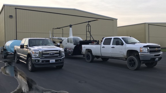
Here we are on Friday morning, just before dawn, ready to head down to Turlock with the mix trailer behind my truck and helicopter trailer behind Sean’s.

I’m very glad I let him have his way. We’re staying in very comfortable rooms at what’s probably the nicest Best Western I’ve ever stayed in. After months of mostly living in my camper, I admit that it’s nice to have a good, long, hot shower every day. So that’s a bonus.

And isn’t that what life is all about? Doing different things? Seeing different things? Experiencing different things?

That’s what it’s all about for me.

But I admit that I do hope Sean finds a new helper for his next job. I’m not staying in California much longer and I’m ready to hang up my spray loader cap.

Phoenix to Sacramento by Helicopter

Another ferry flight with a pilot friend.

[Note: I’ve been working on this post for the past two weeks. Just so busy with other things! Finally got it done today. Better late than never, no? (Cynics need not answer that one.)]

For the fifth February in a row, my company, Flying M Air, has been contracted by an almond grower to provide frost protection for one of his Sacramento-area ranches. Frost protection is one of the lesser-known services a helicopter pilot can provide. We basically fly low-level up and down rows of trees to pull warm air from a thermal inversion down into the tree branches where developing crops — in this case, almonds — are growing. Almonds are susceptible to frost damage for a 4 to 8 week period starting around the time that flowers are pollinated. Because the temperatures are most likely to be lowest at night, most of the flying is done then or, more likely, right around dawn.

Before the Trip

My helicopter had been in Chandler, AZ (near Phoenix) since October when I dropped it off for its 12-year/2200 hour overhaul. Although it technically didn’t need to go in for overhaul until January 2017, I needed it done by mid-February for this work. The overhaul, which I blogged about here, takes a minimum of three months to complete, so I made sure the excellent maintenance crew at Quantum Helicopters got an early start. I don’t fly much in the winter anyway and planned to fill my downtime with some snowbirding, most of which would be in Arizona and southern California. I like snow, but not months of it, and I really do need to be in the sun in the winter time. I’ve structured my work life to give me time to go south every winter.

Paul from Overhaul
Director of Maintenance Paul Mansfield pulls my R44 out of the Quantum hangar after its overhaul on February 20, 2017. At that point, I hadn’t flown for four months and I was ready.

I picked up the helicopter on Monday, February 20 and spent much of the week flying it around Arizona with friends: up the Salt River, to Wickenburg, to Bisbee for an overnight trip, and to Sedona for breakfast. Along the way, I got to fly some familiar routes and see some familiar sights: along the red rock formations of Sedona, down the Hassayampa River Canyon, over the Salt River lakes, and over herds of wild horses in the Gila River bed. I needed to put some time on the helicopter to make sure there weren’t any problems before I left the area.

A lot about the helicopter felt or sounded different — and I tell you, you really get to know an aircraft when you’ve put over 2000 hours on it in 12 years. The auxiliary fuel pump sounded different, the blades sounded different, and the engine start up felt different. I immediately noticed that it was running at a higher cylinder head temperature. The guys who worked on it assured me that was normal until the rings on the newly rebuilt engine were set and I took it off mineral oil, which was recommended for the first 50 hours. The belts were also too loose when the clutch was disengaged and needed to be adjusted. And my strobe light, which had been working intermittently when I dropped it off, was now not working more often than it was. These were all minor things and I had them taken care of on Friday afternoon, when I flew it back from Wickenburg to Chandler. While I was there, the head of maintenance offered to do an oil change and, since the oil was getting dirty, I let his crew do it. I suspect the strobe light fix — which required a new part — was the most bothersome of all the fine-tuning work they did. They’d keep it in their hangar overnight.

My Ride
My ride from Chandler to Mesa with Captain Woody at the controls.

While they got to work, my friend Woody picked Penny and me up in Chandler in his company’s newly leased R44 — with air conditioning, that he had turned on, likely to impress me (it worked) — and flew me to Falcon Field in Mesa, where his company is based. For some reason, I decided to live broadcast the flight via Periscope — how often do I get to be a passenger? — and Periscope decided to feature it. Soon 450+ people were watching our progress across the Chandler/Gilbert/Mesa area. By the time we’d landed, over 4,000 people had seen all or part of it. I think Woody got a kick out of that.

Woody, Jan, and Tiffani operate Canyon State Aero, a helicopter flight school that also does tours and aerial photo work. They have a modest fleet of Schweizer 300s, plus the newly added R44 and an R22 that should arrive next week. I hung around the office while they finished up paperwork and other things, occasionally answering their questions about R44s and R22s. I’m hoping to see that R44 again in Washington this summer for cherry drying.

Afterwards, Jan, Tiffani, and I went out for dinner. We tried for seafood and wound up with Chinese food. Back at their house, we talked and drank wine and watched some amazing time-lapse videos of the desert on Netflix while Penny played with their dogs and stared at their cats. I had an allergic reaction to something — likely the cats — and made the mistake of taking two Benadryl. That pretty much knocked me out for the night.

I woke up early (as usual), feeling refreshed and allergy-free. Woody showed up around 7:30 AM. After some coffee and goodbye hugs all around, Woody, Penny, and I hopped into Woody’s Prius and headed back to Chandler. We hoped to be off the ground by 9 AM.

Getting Started

I’d planned the flight via Foreflight, with fuel stops at Twentynine Palms and Porterville, CA. The total time was estimated at about 6-1/2 hours with a slight headwind. It was a variation of a flight I’d done a few times before, starting with a solo R22 flight in the 2003 from my Wickenburg home to Placerville, CA and ending, most recently, with the 2013 trip that took my helicopter out of its Arizona hangar for the last time and brought it to California for its first frost season. This was the first time I’d be doing the route from Chandler and I worried a bit about making it all the way to Twentynine Palms for fuel. There aren’t any fuel options between Blythe and Twentynine Palms, so having almost enough fuel to get there wasn’t an option. But Foreflight and my own personal experience with the helicopter said I could do it, so that’s what I planned.

Planned Route
Our planned route, as shown on the SkyVector website. Good thing we didn’t fly today when I plotted that for illustration here; there’s a 22 knot headwind.

The weather was absolutely perfect for flying. I’d been monitoring various forecasts for points along our route and it all looked good with the possibility of some wind in the Tehachapi area and a slight chance of rain near our destination. Visibility was good. It would be a bit cool — even in the California desert — but the helicopter has good heat if we needed it. I was looking forward to a good, although somewhat long, flight.

Woody would fly. Woody’s an airline pilot nearing retirement. He’s got a bunch of hours in helicopters and recently got his R44 endorsement. Now he was interested in building some time in R44s. We agreed that he’d pay for fuel — which accounts for less than 1/3 of my operating costs — for the whole trip in exchange for stick time. I didn’t need the time — I have about 3500 hours in helicopters (R44, R22, 206L) — and I’d been flying around all week. And I really don’t mind being a passenger once in a while, especially with a good pilot at the controls. Still, I sat in the PIC seat and he sat in the seat beside me, using the dual controls.

Penny, of course, sat in the back. The back of the helicopter was completely full of stuff, including the wheeling toolbox I’d brought along to hold helicopter parts and accessories — think headsets, charts, log books, etc. — while the overhaul crew stripped down the helicopter to its frame, my luggage, Woody’s luggage, Woody’s pilot uniform, a box of Medifast food (long story), and Penny’s travel bag. I’d forgotten to bring along a bed for Penny, so I folded up my cotton sweatshirt and put that on top of the toolbox for her. She perched up there and slept for most of the flight.

Chandler to Twentynine Palms

I took off from Chandler, crossed the runway per the tower’s instructions, and struck out almost due west. As soon as I got to cruising altitude — 500 feet above the ground (AGL), which was 1700 feet above sea level (MSL) — I offered the controls to Woody. He took them and I settled back for the first leg of the flight.

We flew west along the south side of South Mountain, where we saw a flight of four Stearman airplanes. Woody was pretty sure he knew one of the pilots, but since we didn’t know what frequency they were on, we couldn’t raise them on the radio. (We tried 122.85, 122.75, and 123.45, which are common air-to-air frequencies around Phoenix.) I was kind of surprised to see that we were gaining on them and eventually passed them. (Did I mention that my helicopter is now about 10% faster than it was before the overhaul and now cruises easily at 110-115 knots?) We crossed the north end of the Estrella Mountains just south of Phoenix International Raceway (PIR), mostly to avoid having to talk to the tower at Goodyear. We did tune in, though, and that’s how we learned that Luke Approach was closed so we wouldn’t have to talk to them to cross Luke’s Special Air traffic Rule (SATR). Woody wasted no time getting right on course; I’d already dialed my Garmin 430 GPS in to KTNP for Twentynine Palms.

Flight of Four Stearman
Flight of four Stearman planes, in formation.

Captain Woody
Captain Woody flying past some mountains in California near the Colorado River.

There wasn’t much of anything exciting for the next two hours. We crossed over Buckeye Airport as another plane was coming in, flew north of the steaming cooling towers of the Palo Verde Nuclear Power Plant, paralleled I-10 for a while, and then drifted north of it, crossing SR60 just east of where it joined I-10. Then we crossed a little mountain range and entered the Colorado River Valley about halfway between Parker and Blythe. The Colorado River was a ribbon of blue snaking from north to south beneath us. Then we were in the southern reaches of California’s Mohave Desert, crossing a sandy desert landscape that looked as inhospitable as the Sahara but without the tall dunes. Woody kept pretty close to the GPS track, but did detour around the tallest parts of any mountains in our path. Our altitude varied from 300 to 1000 feet AGL, depending on where we were. For a good portion of the flight, we were the only living things in sight.

Rice Valley
There’s a whole lot of nothing in the California desert between Joshua Tree National Park and the Colorado River.

I did a lot of talking, telling Woody about the helipad on top of Harquahala Mountain where I’d landed my R22 years ago and later my R44, and sharing some of the stories of my flights with low-time pilots who had done ferry flights with me over the years. We agreed that most helicopter pilots didn’t get much real-life experience as they built time as flight instructors. He asked me a bunch of questions about my time working for Papillon at the Grand Canyon. I told him about the excellent learning opportunities a season at the Canyon offered, but lamented about the fact that some of my coworkers had been either immature or cocky head cases. We talked a little about pilots we’d known who had died flying. We agreed that it was ironic that so many people said “he was a great pilot” about pilots who had died in crashes; if he was so great, why was he dead? (There are old pilots and bold pilots but no old, bold pilots.)

We flew through the very northernmost edge of Joshua Tree National Forest, along a road there. When the park fell away to the south, the abandoned buildings started up, one after the other. It was as if hundreds of people had made sad little homes on five-acre lots out there, only to abandon them to the desert wind years later. Many of them had completely blown away, leaving only concrete slabs and scattered debris. I remembered this part of the flight very clearly from my other trips through the area and didn’t take any photos this time around. But if you look on a zoomed-in satellite image of 29 Palms Highway east of Twentynine Palms, you’ll see what I’m talking about. It’s kind of eerie.

East of 29Palms
A satellite image from Google of an area east of Twentynine Palms shows a sample of the scores of abandoned or wrecked buildings out in the desert.

We reached the airport in just over two hours — which is about 15 minutes quicker than I’d planned for. (All my flight plans are for 100 knots airspeed; I’d rather over-estimate time than underestimate it, especially when flying out in the desert.) Woody landed in front of the pumps. We cooled down the engine and shut down. Woody handled the fueling while I cleaned the windows and then added a quart of oil. An old guy with a taildragger flew in and came to a stop nearby; he’d wait for us to leave before refueling. A friend of his drove into the airport and they chatted for a while. They came over to look at the helicopter and Penny, who I’d let out to get some exercise and take a pee. Woody used the bathroom and I took a picture of the helicopter. Then we all climbed back on board, I started up, and I took off to the west.

At TNP
Zero-Mike-Lima at Twentynine Palms.

Twentynine Palms to Porterville

The next stop was Porterville, which was in California’s Central Valley. Unfortunately, we couldn’t fly a direct path to the Porterville because of the restricted airspace between it and Twentynine Palms. So I plotted a course that took us to Apple Valley and Victorville and on to Rosamond before climbing over the pass at Tehachapi and then dropping down into the Central Valley. The route would keep us clear of all the restricted airspace, including Edwards Air Force Base, which is east of Rosamond at the edge of a not-so-dry lake bed.

The desert west of Twentynine Palms was almost as empty as the desert east of it — but not quite. There were homes and small communities scattered about the immediate area, growing ever more rare as we continued west. After a lot of mostly empty desert, the population climbed as we passed near Lucerne and Apple Valley. Woody talked to Victorville’s tower and got permission to cross over the top — we were the only one the controller talked to the whole time we were tuned in. There were dozens of planes mothballed on the tarmac beneath us.

Planes at Victorville
Some of the planes stored at Victorville.

We passed near El Mirage Lake, another dry lake bed that Woody knew from gliders or racing or something I’ve forgotten. Then more empty desert in an area the chart warned us had Unmanned Aerial System operations below 14000 feet. We tuned into Joshua Approach’s frequency as the chart suggested, but never did hear anything about drones.

Then we were south of Edwards Air Force Base and could see the huge dry lake bed where they occasionally landed the space shuttle off in the distance. But because of all the rain California had been having, it looked more wet than dry.

We turned the corner of the restricted airspace and Woody steered us northwest, over the town of Rosamond, where I had the misfortune of being stuck overnight once back in 2003, and toward the windmills on the south side of Tehachapi Pass. There had been windmills — or, more properly, wind turbines — on that hillside for as long as I could remember, but every time I came through the area, there seemed to be more. This time, I decided to share the view on Periscope. Although my voice couldn’t be heard above the sound of the helicopter’s engine and blades, I moved the camera around a lot, showing off the turbines, Woody, and even Penny perched atop the rolling toolbox in back.

Green Foothills
The foothills of the Sierra Nevada, on the west side, just north of Tehachapi. Despite the gray day, they were very green.

We crossed over the pass and began the descent down the other side into California’s Central Valley. It was like a completely different day. On the south side of the pass, in the desert, it had been mostly sunny, bright, and warm. But on the north side, it was mostly cloudy, gray, and cool. But the foothills were so lush and green!

Our flight plan had us heading northwest bound through the valley with our next fuel stop in Porterville. As usual, I tuned in the radio for the next closest airport so we could listen in on any traffic and make a radio call if necessary. There wasn’t much to hear or report on.

When we landed at Porterville, we found a nice looking Bell 47 already parked there. We squeezed in in front of it. While Woody handled the fueling, I wiped down the windows, and Penny began exploring our surroundings, the helicopter’s owner and a friend came out. “You’re from Washington!” the helicopter’s owners — whose name I’ve already forgotten (sorry!) — exclaimed. It turns out that he reads this blog and put two and two together when he saw me. (After all, how many red R44s are piloted by a woman who often travels with a small dog?) We all chatted for a while and Woody asked for a picture of us with my helicopter. Penny made new friends, too — a pair of small dogs that hang out in the airport office. Woody and I visited the rest rooms before climbing back on board, starting up, and continuing our trip.

Maria and Woody
Woody and I posed for a photo with the helicopter at Porterville.

Porterville to Woodland

The last leg of the trip wasn’t very exciting. We flew over a lot of farmland — California’s Central Valley is a major food producer — including more than a few almond orchards in full bloom. We’d already been in the air for more than four hours and I was ready to be at the destination.

Airport
One of the many general aviation airports we passed near or over as we made our way northwest through California’s Central Valley.

One by one the small general aviation airports ticked by beneath us or within sight: Visalia, Selma, Fresno Chandler, Madera, Chowchilla, Oakdale, Lodi, Franklin.

Just past Stockton is when I began to notice the flooding below us. Farmland inundated with water. A broken levee. Closed roads. When we reached the Sacramento River and ship channel, we saw a sea of silty water with occasional “islands” of homes and equipment yards. It was sobering.

California Flooding California Flooding
A few shots (through Plexiglas) of the flooding we flew over just south of Sacramento, CA.

Just past Davis, I asked for and took the controls. I wanted to overfly Yolo County Airport, where I was based last year. The orchard I’m contracted to cover for frost season is adjacent to it; I wanted to fly by and see the condition of the orchard and trees. There was no flooding down there — at least not that I could see — and the trees were in full bloom. Pallets of beehives were scattered among the trees. Business as usual.

I steered us north and zeroed in on our final destination, a small privately owned airport nearby where my camper was already set up and waiting for me. A while later, I was touching down at the fuel pumps, ready for Woody to top off the tanks after our long trip. Once that was done, I started it back up and hover-taxied to a parking spot on the ramp.

Then I was on to my next adventure with Woody and Penny: getting a cab to take me to where my truck was waiting, having dinner at one of my favorite restaurants in town (I highly recommend the venison osso buco), and driving Woody to Sacramento International Airport for his flight back to Arizona. I returned to the helicopter to retrieve my luggage not long after dark and, a few minutes later, was letting myself into my camper where I was soon dead asleep after the long day.

Postscript

The arrangement I had with Woody worked out for both of us, especially since fuel prices have come way down in recent months. He got more than six hours of flight time that cost him less than $500; I saved about $500 on fuel, got company for my flight, and even got treated to dinner with cocktails when we arrived at our destination. And because Woody is an airline pilot, he was able to catch a company flight back to Phoenix at no cost. Win win.

I didn’t mind letting Woody do the flying. I’d put about 10 hours on the helicopter since picking it up from overhaul and knew I’d be putting more time on it soon. Sometimes its nice to be a passenger — especially when you have confidence in the flying capabilities of the guy at the controls. (With a certain “Sunday pilot” flying, I’d rather remain on the ground.) I got to sit back, take a few photos, and enjoy the scenery.

Best of all, my helicopter is now officially back at work, earning me money — even while parked in a deluxe hangar in California.

Blog Back After a Lost day

Outages are never fun.

Well, it looks as if this blog was down for most of March 3.

It was initially reported to me by a friend on Twitter and when I followed up I discovered that he was right —  the blog could not be reached. I called my  hosting company and the hold message mentioned a maintenance issue affecting some customers — apparently including me.

I was very busy for most of yesterday and there was nothing I could do about it anyway. I certainly didn’t expect it to be down for so long. But now it’s back up, and hopefully my hosting company won’t have the same problem again in the future.

Right now, I’m on a little business trip in beautiful Turlock, CA, helping out a friend with his spray business. I’ve been pretty busy with this kind of work for the past week and can’t wait to write a little bit about it. If you follow me on Twitter, you’ll likely see photos and videos —  including live periscope videos — posted occasionally throughout the day. The work is exhausting, and when I’m done for the day I basically fall into bed with my alarm set for 5 AM to start another day of the same.  With rain forecasted for later today and all day tomorrow, I might actually get the chance to finish a blog post in progress and write about my spray loader work. Stay tuned — hopefully, the blog will stay up and running.

And, by the way, it feels great to be so busy after so many weeks of mostly idle time during my extended snowbirding vacation.

My Facebook “Boycott”

I might actually mean it this time.

How many times have I threatened to leave Facebook? How many times have I caved in and gone back? This time might stick.

Facebook LogoFor the record, I have never liked Facebook. Search this blog and you’ll find more than a few posts where I’ve bashed Facebook in one way or another. (Here’s an example from January.) While I will admit that it is a great place to reconnect with people from your past and keep in touch with people you know and like who might not live nearby, it has recently become a tool for the spread of misinformation, helping to divide our country — as if it needed any help. Even after unfollowing or unfriending or even blocking the folks with crazy ideas, there seems to be more arguments on update comments than anything else. It’s also depressing when you realize just how crazy some of your friends or even family members can be.

But what became the last straw back in February was when Mark Zuckerberg, Facebook’s founder and the guy who gets a healthy chunk of Facebook’s revenue, donated $120,000 to CPAC. CPAC, if you don’t know, is the Conservative Political Action Conference, an annual event where right-wing blowhards bash progressives and liberals for being…well, progressive and liberal. Normally I wouldn’t care much about this event, but this year it had made the news by proudly inviting Milo Yiannopoulos, a person who makes his living by publicly trolling people he doesn’t like on Twitter (until he was banned, anyway), Breitbart News (where he was a staff member), and elsewhere. Apparently there’s a lot of money in the trolling and hate speech business because an imprint of Simon & Schuster had signed a book deal with him for an advance of $250,000. I guess the folks at CPAC like the crap Milo was selling because they were welcoming him as a speaker, despite the fact that he’s gay (which I always thought conservatives had a problem with). I have no patience for trolls of any sort and I think that giving credibility to someone like Milo will only further the divide that is destroying our country.

The way I saw it, my participation on Facebook was generating the content and activity that Facebook uses to sell ads. In a way, part of that $120,000 donation made by Zuckerberg to CPAC was coming out of my pocket. I didn’t like that. So I posted a link to the Media Matters article I linked to above on my Timeline, informing my friends and followers that I was out of there. Then I logged off from everywhere I was logged in — there’s actually a link buried in Facebook settings to do that — deleted all the cookies in my browser so Facebook couldn’t follow me around anymore, and deleted the Facebook app from my mobile devices.

I suffered from withdrawal for about two days. Then I pretty much forgot about it. I did step up my Twitter use a bit. I’m enjoying the political activism there. One of my recent tweets to [so-called] President Trump went viral and was mentioned in a magazine article. That was kind of fun.

I’m in California now, helping out a friend with a few spray jobs he has and doing some recreational flying now that my helicopter is out of overhaul. (I’m going to Lake Berryessa today, hopefully to see its “Glory Hole.”) I’m also trying to set up a lunch date with my friend Shirley, who lives in the Sacramento area. She and I usually get in touch on Facebook — frankly, she’s one of the people I miss from Facebook — and I wanted to see if I’d missed a message from her. (I never used Facebook Messenger on don’t plan on starting.) So I logged in today.

No message from Shirley, but two messages from friends. One was a link to a neat airport home in Bisbee, where I’d recently visited with friends. The other was spam from a new “friend” who I’m starting to think is an idiot who needs to be unfriended. There were also 57 notifications that I looked at. I started to follow up on them, but grew bored and discouraged after just a few. Same old shit. Seriously. This person liked this. That person commented on that. These people liked that page. I realized, with a start, that I really didn’t care about the notifications. And when I found myself reading an update written by one of my friends, I realized that I could easily get sucked back in anyway. So I logged out.

I’m not going to try to convince anyone to stop using Facebook. I know it’s a waste of my time but it’s apparently not a waste of other people’s time. Besides: who am I to tell people how to spend their time, which is the most valuable thing they have?

But I’m so glad to be off Facebook and I really hope I can stay that way.

Oh, and in case you missed the news, Milo lost that CPAC speaking gig, book deal, and Breibart job.

Karma, baby. It rocks.

Snowbirding 2017 Postcards: Salton Sea Birds

A few photos from my visit to the Salton Sea.

While I was traveling around Arizona and California this winter, I had more than a few opportunities to do some photography. At the Salton Sea in California, which I visited in mid January, I spent much of a day photographing the birds along the salty water or walking on the barnacle beach. For most shots, I used a 70-300mm Nikkor lens on my Nikon D7100 DSLR. I thought I’d share the best of them in a quick “postcards” blog post here.

I suppose I should say a few things about the Salton Sea. It’s a strangely beautiful, highly saline lake in the middle of the desert in southern California. It’s surface is roughly 235 feet below sea level. It was formed years ago when the Colorado River flooded and jumped its banks, pouring water into the low-lying desert for about 16 months. There are no outlets; the lake is fed by irrigation runoff and kept level by evaporation. The salt level rises steadily. The beaches are not sand; they’re barnacles. The place is home to more than 300 species of birds, many of which are migratory. The visitor center has a lot of good information with friendly, knowledgeable staff. I would definitely visit again. You can learn more on Wikipedia and the Salton Sea Authority website.

Here are the bird photos. One of these days, I might get back into this blog entry to add captions with the names of the birds. If you know any that aren’t named here, please comment to let me know and I’ll add a caption.

Salton Sea Birds

Salton Sea Birds

Seagull at Salton Sea
Seagull at the Salton Sea.

Salton Sea Birds

White Heron at the Salton Sea
White Heron at the Salton Sea.

White Pelicans
White Pelicans at the Salton Sea.

Salton Sea Birds

Salton Sea Birds

Seagull at Salton Sea
Seagull at the Salton Sea.

Salton Sea Sunrise
Birds flying at sunrise over the Salton Sea.