From the air.
One of the benefits of being a single pilot helicopter operator — as opposed to a big helicopter tour company or flight school — is that I can take flying gigs that many larger operators have to turn down. This is one of the reasons I fly, once or twice a year, for the leader of photographic expeditions in the southwest. He’ll call me when he has a group together and ask me to fly them around Lake Powell for aerial photo sessions of the lake.
It’s a great gig and I love it. What’s not to like about flying over some of the most spectacular scenery in the southwest for several days in a row and getting paid to do it?
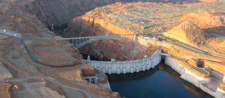
 Last year my husband Mike came along for the ferry flight to Page. We stayed two nights — I fly only around sunrise and late afternoon for my clients on this gig — and departed early the next morning for Wickenburg. That’s when Mike took this shot of the Glen Canyon Dam with the morning sun casting shadows in the canyon.
According to Wikipedia:
Glen Canyon Dam is a dam on the Colorado River at Page, Arizona, operated by the United States Bureau of Reclamation. The purpose of the dam is to provide water storage for the arid southwestern United States, and to generate electricity for the region’s growing population. The dam has been controversial since its inception, because it caused the flooding of the scenic Glen Canyon and its tributaries to create a man-made reservoir, Lake Powell.
And:
The Glen Canyon Dam is a 710 foot high structure which provides more storage capacity than all other storage features of the Colorado River Storage Project combined. The concrete arch dam has a crest length of 1,560 feet and contains 4,901,000 cubic yards of concrete. The dam is 25 feet wide at the crest and 300 feet wide at the maximum base. Its height above the Colorado River is 587 feet.
Unlike the Hoover Dam, which is the next dam down river in the Colorado River Storage Project, the Glen Canyon Dam has always had a separate bridge for crossing the river — the 1,271-foot bridge you see beside the dam in this photo. This, and its remote location, make it is less of a security concern than the Hoover Dam. (I’m not sure if the construction on the new bridge near the Hoover Dam is done yet; I need to fly up there one of these days and check it out.)
Lake Powell is one of the destinations on the Southwest Circle Helicopter Adventure and Land of the Navajo Helicopter Excursion that Flying M Air offers. I do these trips in the spring and autumn, when there are fewer people in the area but the weather is still warm enough to enjoy outdoor activities.
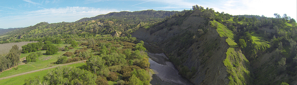
 The lake is highly controversial. The dam flooded a huge area of pristine canyon lands with many archeological sites and even a few active settlements. This land was mostly inaccessible, like so much of America’s desert wilderness. That may be why the decision to build the dam was made. Although the Sierra Club would like nothing more than to destroy the dam and drain the lake, at this point I think it’s too late. The canyon walls are stained with minerals from the water and all plant life beneath the current water level is dead. It would take hundreds, if not thousands, of years for the area to be restored to its original health and beauty. Sadly, the need for water in the desert southwest has become more important than the need for another remote wilderness. We should be thankful that the original plan to stretch a dam across the Grand Canyon was scrapped, as we could have lost that instead.
 I think we should be satisfied with the beauty of the lake and the recreational opportunities it provides. Although most boating activity goes on in the Page area, there’s nothing so peaceful or relaxing as climbing aboard a houseboat for a week-long trip up lake, where few day-trippers venture. Exploring the side canyons by small boat or on foot gives you a sense of what it might have been like before the waters rose.
Indeed, that’s where I hope to retire when I get too old to fly: on a houseboat at Lake Powell.
 The bird took off and I caught him in flight.
 I took this shot on the first glacier. It’s a huge boulder — probably 8 feet long by 6 feet wide by 3 feet tall — and it’s being held horizontally off the surface of the glacier by a column of ice. The ice, of course, is melting — not from global warming but by summer warmth — and I suspect this boulder is now lying elsewhere on the surface of the glacier, a bit downstream as it moves with the flow of the ice. Perhaps it’s sitting in a similarly awkward position and another tourist has snapped a shot of it — maybe with his wife or kid sitting or standing on it! That’s the weird thing about glaciers: they’re always changing, always moving. The rocks and boulders on their surface are just along for the ride.
 The Deception Pass Bridge crosses over this strait, about 180 feet above the water (depending on the tide). There are actually two spans to the bridge with a small uninhabited island between them. There’s limited parking on both ends of the bridge with plenty of places to stop and take in the view.
 The bridge includes a 3-foot wide sidewalk on each side, which is definitely not recommended for those who are afraid of heights. We walked across on one side and back on the other. To prevent people from crossing the relatively busy roadway, a flight of stairs leads to a pathway under the bridge on either bank. That’s where I took this photo. I liked the symmetry of the construction and the fact that I could frame the photo in such a way that the pattern seemed to go on forever. This is a theme I try to capture in my photos when I can: infinity.
 Last year my husband Mike came along for the ferry flight to Page. We stayed two nights — I fly only around sunrise and late afternoon for my clients on this gig — and departed early the next morning for Wickenburg. That’s when Mike took this shot of the Glen Canyon Dam with the morning sun casting shadows in the canyon.
 The lake is highly controversial. The dam flooded a huge area of pristine canyon lands with many archeological sites and even a few active settlements. This land was mostly inaccessible, like so much of America’s desert wilderness. That may be why the decision to build the dam was made. Although the Sierra Club would like nothing more than to destroy the dam and drain the lake, at this point I think it’s too late. The canyon walls are stained with minerals from the water and all plant life beneath the current water level is dead. It would take hundreds, if not thousands, of years for the area to be restored to its original health and beauty. Sadly, the need for water in the desert southwest has become more important than the need for another remote wilderness. We should be thankful that the original plan to stretch a dam across the Grand Canyon was scrapped, as we could have lost that instead.
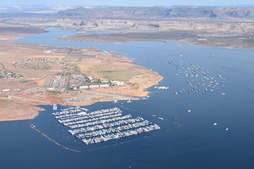 I think we should be satisfied with the beauty of the lake and the recreational opportunities it provides. Although most boating activity goes on in the Page area, there’s nothing so peaceful or relaxing as climbing aboard a houseboat for a week-long trip up lake, where few day-trippers venture. Exploring the side canyons by small boat or on foot gives you a sense of what it might have been like before the waters rose.
 This case of cakes and pies and pastries called to me. In Arizona real bakeries are a rarity. Supermarkets here are big and new and almost all of them have a bakery department. Some are actually quite good. Our recently renovated Safeway here in Wickenburg has a nice display case of cakes and cookies these days. But I’ve never seen any bakery in Arizona with a display like this. And I’ve never been to a bakery in Arizona worth writing about.