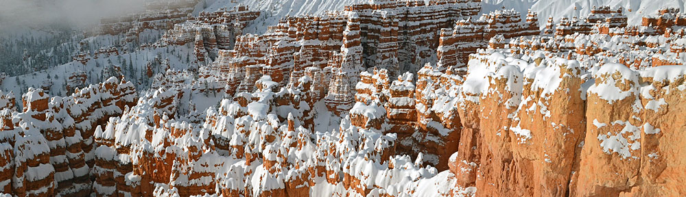
Walking on glaciers.
I’ll admit it: when we went to Alaska in June 2007, we did 2/3 of our visit the lazy tourist way: on a cruise ship. (Seeing what the cruise ship companies did to the quaint port cities is why we’ll probably never cruise again.) Of course, you don’t spend all your time on the ship unless you’re easily entertained by on-board activities. We’re not. So each day, in each port, we went on an excursion.
In Juneau, we took the “Pilot’s Choice” flight with Temsco. Temsco is a huge helicopter tour operator in Alaska with bases in most of the port cities. They fly A-Stars — at least they did in Juneau and Skagway. The Pilot’s Choice tour is supposed to be exactly that: the pilot’s choice of where to fly and land. What interested us is that the tour included two glacier landings. So not only would we see our first glaciers from the air, but we’d actually land on two of them and walk around.
Sounds great, right? It is! This tour is what sold me on the idea of working in Alaska next season. The pilot flies up and down these glacial valleys with all that blue ice beneath us. There are waterfalls and lakes and the clear lines of glacial moraines. The pilot explains what we’re seeing, so it’s a great introduction to the shrinking world of Alaskan glaciers.
Then, of course, he lines up for approach and lands on a relatively flat bit of glacier. He cools down the engine for a few moments, shuts down, and lets us out when the blade stop. We can then wander around the glacier for about 15 minutes before loading back up and repeating the process on another glacier with different views miles away.
 I took this shot on the first glacier. It’s a huge boulder — probably 8 feet long by 6 feet wide by 3 feet tall — and it’s being held horizontally off the surface of the glacier by a column of ice. The ice, of course, is melting — not from global warming but by summer warmth — and I suspect this boulder is now lying elsewhere on the surface of the glacier, a bit downstream as it moves with the flow of the ice. Perhaps it’s sitting in a similarly awkward position and another tourist has snapped a shot of it — maybe with his wife or kid sitting or standing on it! That’s the weird thing about glaciers: they’re always changing, always moving. The rocks and boulders on their surface are just along for the ride.
I don’t remember the names of the two glaciers we landed on. All I remember is the beauty of the flight. I flew for an entire season at the Grand Canyon and thought that was beautiful. But in Alaska, with the constantly changing terrain and flight plans that vary based on the weather, I don’t think I’d ever get tired of flying. So I’m getting my instrument rating to make me just a little more attractive to employers next April when the season starts.
Who knows? Maybe next summer I’ll be spending more time walking on glaciers.

 The Deception Pass Bridge crosses over this strait, about 180 feet above the water (depending on the tide). There are actually two spans to the bridge with a small uninhabited island between them. There’s limited parking on both ends of the bridge with plenty of places to stop and take in the view.
 The bridge includes a 3-foot wide sidewalk on each side, which is definitely not recommended for those who are afraid of heights. We walked across on one side and back on the other. To prevent people from crossing the relatively busy roadway, a flight of stairs leads to a pathway under the bridge on either bank. That’s where I took this photo. I liked the symmetry of the construction and the fact that I could frame the photo in such a way that the pattern seemed to go on forever. This is a theme I try to capture in my photos when I can: infinity.
 In May 2006, a
 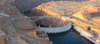 Last year my husband Mike came along for the ferry flight to Page. We stayed two nights — I fly only around sunrise and late afternoon for my clients on this gig — and departed early the next morning for Wickenburg. That’s when Mike took this shot of the Glen Canyon Dam with the morning sun casting shadows in the canyon.
 The lake is highly controversial. The dam flooded a huge area of pristine canyon lands with many archeological sites and even a few active settlements. This land was mostly inaccessible, like so much of America’s desert wilderness. That may be why the decision to build the dam was made. Although the Sierra Club would like nothing more than to destroy the dam and drain the lake, at this point I think it’s too late. The canyon walls are stained with minerals from the water and all plant life beneath the current water level is dead. It would take hundreds, if not thousands, of years for the area to be restored to its original health and beauty. Sadly, the need for water in the desert southwest has become more important than the need for another remote wilderness. We should be thankful that the original plan to stretch a dam across the Grand Canyon was scrapped, as we could have lost that instead.
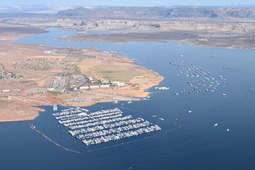 I think we should be satisfied with the beauty of the lake and the recreational opportunities it provides. Although most boating activity goes on in the Page area, there’s nothing so peaceful or relaxing as climbing aboard a houseboat for a week-long trip up lake, where few day-trippers venture. Exploring the side canyons by small boat or on foot gives you a sense of what it might have been like before the waters rose.