Taking a Stand Against the Full Body Backscatter X-Ray

Stand up for our rights. You can make a difference.

Yesterday, when I went through security at Seattle-Tacoma Airport (SEA) for a flight to Wenatchee Pangborn Airport (EAT), I was one of four people in a five-minute period who opted for a pat-down rather than subject my body to the highly controversial full body scanner or backscatter x-ray machine.

BackscatterWikipedia image. (No, it’s not me. Sheesh.)

Because we had to wait while the TSA called screeners for each of us, we discussed why we’d made the decision. The four of us agreed that the use of backscatter x-ray technology for security screening was a violation of our privacy and constitutional rights. This “virtual strip search” is not only ineffective for revealing hazardous materials carried by determined terrorists, but it raises additional health concerns. Two of us were certain that the machine was hazardous — more on that in a moment — I’m not convinced either way.

All four of us had decided to make a stand against the use of the equipment by forcing the TSA to conduct a pat-down each time we were asked to go through the machine. This inconveniences the TSA far more than it inconveniences us. It only adds about 10 minutes to your screening time, but it forces the TSA to shuffle around staff, thus slowing down the whole security line. If enough people do this on a regular basis, the TSA will be forced to increase its staff to handle screening needs during busy times — or simply cease using the machines. After all, the normal metal detectors are still there and are used when the backscatter x-ray machines are down for maintenance. Why is it that they’re good enough at, say 5:10 to 5:30 PM one day but not good enough five minutes before or after that? It’s all bullshit, if you ask me.

One by one we were taken away for our pat-downs. Soon, it was just me and a man left chatting. He said he always gets the pat-down and is convinced that the machine is dangerous. I told him that I always ask for a private screening. This doubly inconveniences the TSA because it requires not only a private space, but two TSA screeners of the same gender: one to conduct the pat-down and another to observe — so you can’t cry foul, I suppose.

In addition, because they can’t separate you from your luggage, they must carry all your luggage and bins into the screening room with them. If you have a lot of stuff — think laptop, coat, belt, purse, briefcase, carryon bag, etc. — that could take more than one trip. You’re not allowed to touch it once you opt out so they’re forced to carry it for you to the screening room. One time, I had three of them tied up carrying my stuff around.

The man I was speaking to obviously liked the idea as much as I did and he opted for a private screening, too.

While a lot has been said about the obtrusiveness of pat-downs, having gone through it three times now, I can assure women that it isn’t a big deal. I didn’t feel violated or uncomfortable at any time. It’s just another woman wearing gloves patting you down. I’ve had seamstresses get more friendly when fitting me for a gown.

I try to make the situation more tolerable by chatting up the TSA women, teasing them gently, making sure they understand that I’m just opting for the pat-down to “get my money’s worth” out of the screening process. Occasionally, I’ll get one that admits the process isn’t effective or doesn’t make sense, but most times they’ll stop short of actually saying so. Yesterday, one of the women actually admitted that she thinks the backscatter x-ray machine is dangerous. Not only will she avoid it, but she’s told her mother not to go through it. Good to know that the TSA can’t even convince it’s own people about the safety and security of the system.

I usually mention the Israeli airport security system as an alternative method of screening. Often, they are familiar with it. Yesterday, one of the women said that they couldn’t use that system “because we’re not allowed to profile.” We both agreed that profiling should be allowed — at least to a certain extent. But rather than the kind of racial profiling Sheriff Joe uses to harass Hispanic people in the Phoenix area, airport profiling should look for signs of nervousness or other indicators that might suggest a person has something to hide. This is psychological profiling that requires extensive training and dedicated screeners. Unfortunately, members of the U.S. government would rather spend our tax dollars on sophisticated machines manufactured by their friends than useful training for TSA and other security agents.

As usual, yesterday’s pat-down was a non-event. I made my statement and was very pleased to see that I wasn’t the only one doing so. My only question is this: Why are most people acting like sheep, walking through a machine that displays nude images of them to strangers while dosing them with radiation?

The GOP and its propaganda arms (think Fox News and Rush Limbaugh) are constantly talking about government intrusion in our lives and violations of our constitutional rights, yet I don’t see any of them complaining about this complete disregard for privacy and Fourth Amendment rights. Why not?

Don’t they see that every time they introduce a measure like this, they’re subjecting us to more government intrusion and violating more of our rights?

I’m an American and I value my rights. Because of this, I arrive at the airport an extra 15 minutes early and do my part to protest the use of this ineffective, unnecessary, and possibly harmful intrusion of my privacy and violation of my rights.

If you care about your rights, you’ll do the same.

A Few Aerial Views from Today’s Flight

Any excuse to fly.

Don and I went flying today. Don had left his jacket at the Payson Airport (PAN) restaurant. I had just gotten a pair of Bose A20 headsets I wanted to try. Seemed to make sense to fly up to Payson, retrieve Don’s jacket, and give the headsets a try.

We left Deer Valley Airport (DVT) at about 10:30 AM. As usual, I had a GoPro hooked up on the helicopter’s nose, recording 720p video. The photos throughout this blog post are frames from the resulting 2 hours of video. I figure I’ll let the photos and captions tell the story.

Northbound over DVT
My usual view of DVT as I depart to the north. Helicopters are instructed to cross the runway midfield at 500 feet AGL. Planes take off and land beneath us; the traffic pattern is above us. (You can see a complete departure on video here.)

Johnny Carson's House?
Don was told that this little ranch once belonged to Johnny Carson. Who knows? All I know is that it’s in dire need of a new roof right now.

Indian Ruins
Although nearly impossible to spot in this photo, this ridge was completely covered with the ruins of an ancient indian pueblo. I can think of nearly a dozen such sites — all inaccessible by road or trail — in Arizona.

Desert Valley View
On first reviewing the video, I thought this was the Verde River Valley. It’s not. The Verde River is over the next mountain range. Whatever.

Verde River
We joined the Verde River just north of Horseshoe Lake, which is pretty much empty right now.

Verde River
The river twists and turns through a canyon that’s wide in some places and narrow in others.

Verde River
Sometimes I follow the river quite closely.

Verde River
It’s great to fly with another pilot who doesn’t freak out when you bank a little sharply. What do you think? Not quite 45°, huh?

Verde River
The trees along the river — and in any narrow canyon where cottonwoods can grow — are all beginning to change color.

Verde River
Who says Arizona doesn’t have seasons?

East Verde River
At the Confluence of the East Verde River, we turned right and followed that toward Payson. The wind kicked up here and we got bounced around a little, but nothing bad enough to spoil the flight.

Payson Airport
Eventually, we arrived at Payson Airport. I crossed the runway midfield low-level and set down on the ramp.

At the airport, Don and I went into the restaurant and had a late breakfast. There were boxing up pies for sale — tomorrow is Thanksgiving after all — and I bought two of them. Don and I dug into one right at the restaurant, since Mike doesn’t like strawberry rhubarb and Don and I both do.

Departing Payson
We took off along the taxiway (sort of) and headed south along the main road toward Roosevelt Lake.

Rye, AZ
Along the way, we passed over the town of Rye, shown here in its entirety from about 500 feet up.

Tonto Creek
We hooked up with Tonto Creek and followed it down along a canyon neither of us knew existed. There’s nothing I like better than discovering new places when I’m out flying. This might have been the first time I’d flown between Payson and Phoenix.

Roosevelt Lake
Eventually, we reached the north end of Roosevelt Lake on the Salt River. The water level was down, but not nearly as much as Horseshoe Lake.

Roosevelt Lake Bridge
The lake is created by a dam on the Salt River. There’s a really nice looking bridge near it. I had to get kind of close to get this shot. Funny how the water looks green from certain angles.

Dam at Roosevelt Lake
We rounded the bend at the dam and headed down the Salt River Canyon toward Phoenix.

Apache Lake
Next up was Apache Lake, shown here near the motel/marina complex, which is quite a way down the Apache Trail’s unpaved road. As we neared the canyons on the downstream side of the lake, the wind started bouncing us around pretty good.

Apache Lake Dam
This dam creates Apache Lake. Two items of interest here: the helipad on the lake side of the dam itself — really! — and the network of wires running down the canyon. I would not like to land at that helipad. (Well, actually, I would, but that’s because I’m curious to see if I could do it gracefully.)

Canyon Lake
Canyon Lake is one of my favorites. A bit more accessible by car than Apache, the lake winds through canyons after this point. Next year, when I bring my little boat back from Washington State, I’ll take it out on this lake for a weekend with my camping gear. Lots of places to camp along the lake.

Saguaro Lake
We flew past the big “S” of Saguaro Lake from the uptake side. Saguaro is the most accessible of the Salt River Lakes so it’s usually the busiest on weekends. We flew over on a Wednesday, so it was pretty quiet.

Fountain Hills
After flying along the Salt River for a while and seeing a handful of wild horses standing in shallow water there (sorry, no good photos), we headed west, over Fountain Hills.

Scottsdale
Then we crossed over the southmost end of the McDowell Mountains and descending into the Scottsdale area. We headed toward Scottsdale Airport (SDL) and crossed over the top at 500 feet AGL, right behind a Cessna doing touch and goes. Then I adjusted course to Deer Valley Airport.

Landing at Deer Valley
I landed at Deer Valley from the west, as I usually do, making a sharp right turn over Deer Valley Road. The red circle in this photo is my landing zone at Atlantic Aviation there. It’s a tricky LZ, mostly because it’s such a tight confined space and there’s a few light poles to avoid on the way in.

Don left while I took my time getting my things together. It had been a nice day out.

Any excuse to fly works for me.

The Old Gold Dredge in Buckhorn Wash

The story I heard with yesterday’s photo.

I heard the story years ago.

A gold miner had built a dam in Buckhorn Creek, north of Phoenix, east of Wickenburg. He’d put a boat on the resulting body of water to dredge for gold. But a heavy rain caused the dam to fail. The water emptied southeast down the creek, taking the boat with it. It was soon stuck in the sand down the dry wash.

Location of DredgeAnd there it remains.

We flew over it yesterday in Don’s helicopter. I’d shown it to him a while back while flying out in that area and he’d tried to relocate it several times since then. Yesterday, I found it for him again and he marked it with his GPS. I shot this photo.

Buckhorn Dredge

Doesn’t look much like a boat, does it? Vandals have been at it rather violently, it seems. And I’m sure more than a few minor floods helped the decay. When I first saw it, it looked like the image about a third of the way down this page, which was dated 2003. You can see an even later photo near the bottom of this page.

I don’t know if the story I heard is true. And I don’t know when all this happened. I’d love to know more about it, so if you have any ideas or links to additional resources, please share them in this post’s comments.

It’s a good example, however, of some of the really weird things we fly over out in the Arizona desert.

A Trip around the Peninsula, Day 3: Port Angeles to Clallam Bay

We take a road trip around the Olympic Peninsula in Washington state.

After three months contractually bound to the Quincy and Wenatchee areas of Washington, I was finally off contract at the end of August. Mike flew out to Washington and we went on a road trip to the Olympic Peninsula. This series of blog posts is a summary of that trip, with photos.

Back on the road, exploring Olympic National Park and the Pacific Coast of Washington.

We left the hotel in Port Angeles early on Wednesday. With half a cup of unsatisfactory hotel room coffee in my stomach, I hit the Starbucks in the local Safeway supermarket while Mike topped off the truck with diesel. Then we started up the road to Hurricane Ridge in Olympic National Park, leaving Port Angeles behind.

It was so early that when we reached the park entrance, no ranger was there to check our park pass.

Tunnel on Hurricane Ridge Road
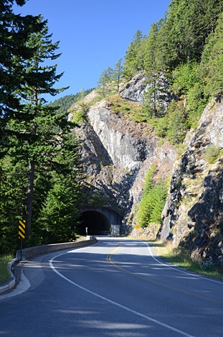
The road climbed south slowly into the mountains on a narrow strip of park land. We found a parking area right before one of two tunnels and Mike parked the truck. There was a view to the northeast and we could clearly see the Juan De Fuca Strait, which runs between Washington and Canada’s Vancouver Island. It was relatively hazy and the conditions weren’t good for photography.

I spotted a paved path that wound into the woods and we followed it with our coffee cups and bags of breakfast pastries in hand. At the end of the short path was a viewpoint that looked southeast. The air was hazy; a wildfire was burning out in that direction beyond the mountains. Some interpretive signs talked about the rivers that ran invisibly in the cuts between mountain arms in front of us. I wasn’t sure, but I thought I could hear the water rushing in the distance.

We sat down on some steps and had our breakfast. A few people came and went.

Back in the car, we continued up the road. I should mention here that it was a remarkably beautiful day for that area of the country — not a cloud in the sky. Apparently, the area gets a lot of rain. We didn’t see any for the entire time we were traveling there, although we did run into some marine layer fog banks — more on that later.

LupinesNear the end of the road was the Hurricane Ridge visitor center, a building with a gift shop, food, and great views to the south. There were also a few paved and unpaved paths that wound through grassy, flower-strewn meadows. We parked the truck and went for a walk. The quantity and size of lupine were phenomenal. Tall stalks of magnificent purple flowers seemed to grow everywhere.

Although the views in every direction were magnificent, a layer of smoke and haze from the wildfires miles away made it difficult to capture images of what should have been pristine wilderness. There was still snow on the peaks to the south of us and, with a pair of binoculars, we could examine the few remaining glaciers from afar. (There was also snow at our elevation, mostly on the north side of hills that would get little direct sunlight during the day.)

Snow-Capped Mountains

Mike and I spent quite a bit of time photographing the wildflowers. Although lupines dominated the scenery, there were some other wildflowers to capture in pixels. You can see two of my better closeup shots below. (You can click any photo with a watermark to see a larger version in my photo gallery.)

Butterfly and Bee Indian Paintbrush

We weren’t the only photographers up there, either. I saw at least two other people with tripods. (I was using my monopod.) You really needed some kind of platform to steady the camera when doing closeup images of the flowers.

After close to two hours exploring the area, we hopped back in the truck and continued down the road to the trailhead for Hurricane Hill. We wandered about a half mile up the trail, trying hard to lose a group of noisy hikers who seemed to pause every time we did. We finally turned around and walked back to the truck, eager to continue our trip.

We retraced our route back down the road, turning just after the park gate onto Little River Road. This road, which was mostly outside the park limits, was a “shortcut” that would take us to the Elwha area of the park. It was mostly paved; the unpaved part was smooth enough. We drove past patches of clearcut forest, along with areas of obviously new growth. The Olympic Peninsula — as well as much of Washington and Oregon states — have many tree farms where trees are planted and harvested for lumber. Most of the old growth forest is gone; the trees in the new forests have straight, narrow trunks.

We turned into the park road toward, heading toward an observation point. We flashed out park pass at the ranger and got a map for our efforts. Then we followed the Elwha River south. The water was rushing — even this late in the year — and there were huge pileups of tree trunks deposited by seasonal flooding.

Picnic Spot
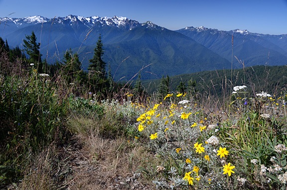
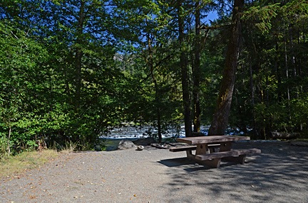
We were hungry and planned to dig into some of the cheese we’d brought along when we got to the observation point near the end of the road. But the road was closed for some kind of construction. So instead, we turned into the Altair Campground, which was mostly empty, and pulled into the first campsite, which was right along the river. We carried the cooler over to the picnic table, opened it up, and had a great meat, cheese, cracker, and cucumber lunch.

Afterwards, we headed out of the park, following route 101 northwest. A Piedmont on Crescent Lake, we turned north on a road that wound through more forest to Route 112. Eventually, we were back on the north coast of the peninsula.

We made a brief stop at a small park where we walked along a rocky beach. The tide was mostly out and the weeds that had been deposited on the shore were stinky and buzzing with flies. We didn’t stay long.

Route 112 left the shore and came inland, intersecting with Route 113. We followed 112 north to Clallam Bay. From there, we passed through the small communities of Sekiu, which appeared to be a very large RV park, and Neah Bay, a town on Makah Reservation. We followed the signs to Cape Flattery on a road that cut through the tip of the peninsula to bring us to the ocean side. We followed the road to the end where there was a relatively full parking area for the Cape Flattery trail.

Despite the fact that this trail is so far away from “civilization,” it’s really worth visiting. It immediately dives into the forest on an easy-to-follow pathway that descends gently under a dense canopy of evergreen trees. Most times, this trail is likely dripping wet with typical coastal rain forest weather, but the day we visited it was damp but mostly dry, with bright afternoon sunlight filtering through the branches. Where the trail was likely to encounter mud, it was “paved” with wooden planks or round cross-sections of large logs. It gave off a sort of magical feeling, as if we’d entered into a fairy tale, following the path of Little Red Riding Hood or Hansel and Gretel — but without the danger at the end.

Mike At Cape Flattery
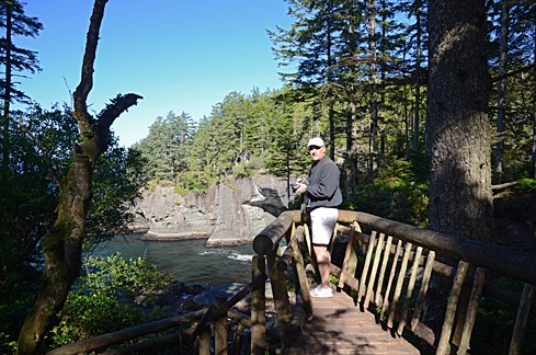
As we got closer and closer to the point, we could clearly hear the ocean waves crashing against rocks. There were a handful of short side trails to points where you could see the rocky shoreline. Some of them had been built up with rustic log rails to prevent a fall into the water below.

Stacks
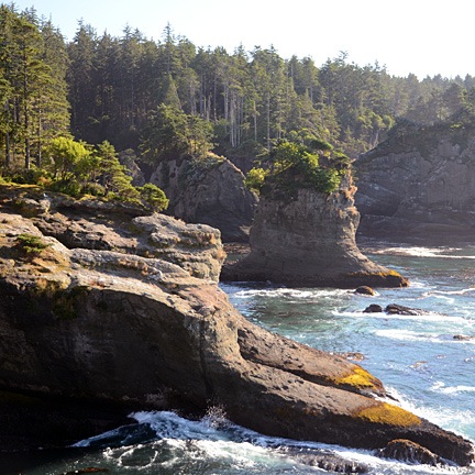
At the end of the trail was a platform that looked out to the northwest. There was an island out there with a lighthouse on it. To the north, was the opening of the strait and Vancouver Island; a container ship slowly made its way in toward the ports. Waves crashed on the shore against odd-looking formations called “stacks.”

Natural BonsaiBeyond the platform, a lone tree grew like a natural bonsai right at the edge of the cliff. Its gnarled trunk was twisted and curved from years of exposure to the elements. It made an interesting foreground subject for a view of the ocean and stack beyond it. I can imagine the shot being much better, with first light on the scene and a coastal mist partially obscuring the offshore landmarks.

By this time, it was late afternoon and we needed a place to spend the night. We debated about driving all the way back to Forks, which was on the way south. The Maps application on my phone — once I got back within range of the network — mentioned lodging farther south on the coast. I called the phone number. A recording answered and said the office was closed. It was 5:30 PM. I couldn’t understand how a place with cabins could just close at 5. We drove past and saw a bunch of relatively nice cabins, mostly unoccupied, adjacent to an RV park. The office was indeed closed. Their loss.

So we backtracked through Neah Bay and headed toward Forks. Despite very promising signs at Neah Bay about lodging, there was no place there I’d even consider staying. Between Sekiu and Clallam Bay, we spotted a motel with a restaurant next door. We pulled in.

I can’t remember the name of the place and that’s probably a good thing. It was not pleasant. The unit they put us in was at the end of a single-wide manufactured building. It consisted of two very small rooms, one of which had a kitchen it it. Although the place was clean, it was extremely run down and had a weird smell. I think it caters to fishermen. It did have a full sized refrigerator, which was good for us, because it let us store our remaining cheese and re-freeze the bottled water and freezer packs we were using to keep them cold. And it was quiet. And the restaurant was next door.

And, oh yeah: it was pretty cheap.

We had dinner in the restaurant next door. I had a fried fish platter, which was actually pretty good. We shared an ice cream sundae. Then we went back to our room with its cardboard walls, and called it a day.

I was exhausted.

Our Route:

A Trip around the Peninsula, Day 2: Victoria, BC

We take a road trip around the Olympic Peninsula in Washington state.

After three months contractually bound to the Quincy and Wenatchee areas of Washington, I was finally off contract at the end of August. Mike flew out to Washington and we went on a road trip to the Olympic Peninsula. This series of blog posts is a summary of that trip, with photos.

On the recommendation of several people, we spend the day in Canada.

We started the second day of our trip with a quick breakfast at the hotel and a trip to the ferry terminal. The plan was to spend the day in the Canadian city of Victoria, a 90-minute ride from Port Angeles on the Black Ball Ferry Line’s M.V. Coho.

We’d learned, belatedly, that if you wanted to take a car on the ferry to Canada, you needed to get to the terminal for security inspection 90 minutes before the 8:20 AM sailing. That was not possible. So we walked on board, assured that there was plenty within walking distance of the ferry terminal on the other side. There was also the usual collection of taxis and other means of transportation.

MV Coho
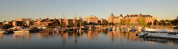
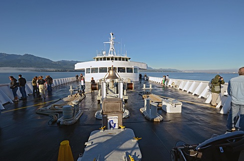
Although the sky was clear in Port Angeles, we hit fog within 15 minutes of departure. The crew shooed all passengers away from the bow of the boat and we went inside. We filled in our immigration paperwork and found a comfortable place to sit. I was feeling more than a little queasy from the rocking of the boat, but that cleared up soon enough. So did the fog. We went back out on deck as we came into Victoria Harbor. A seaplane was just landing. It was another beautiful day.
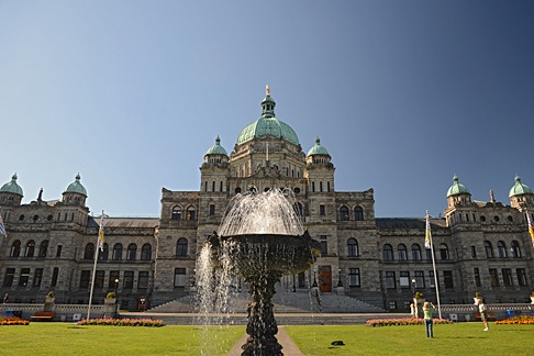
We spent the entire day touring the harbor area — and a bit beyond it — on foot.

Assembly BuildingFirst up was the Legislative Assembly of British Columbia, a large domed building clearly visible from the ferry terminal. Mike and I are big fans of architecture, so we wandered over to take a closer look. We walked past a very large statue of Queen Victoria and an ornate fountain to get a closer look at the building’s symmetry. Then we walked down the main path and up the steps to the public entrance.

Inside the Assembly Building
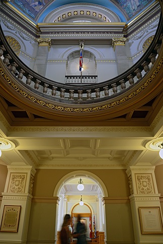
We were pleased to learn that the building was open to the public and wasted no time exploring the public areas inside. The building, which was completed in 1898 and restored in 1973 is in magnificent condition, full of wonderful architectural touches. I picked up the self-guided tour booklet but didn’t really consult it much. It was nice to simply wander around, from room to room, although I do wish we’d taken the guided tour.

Afterward, we walked north on Government Street to the Empress Hotel. I’d read somewhere that the hotel was the place to get afternoon tea, so we found the reservation desk and made reservations for 4:15 PM. That meant we’d be taking the 7:30 PM ferry back to Port Angeles.

Mike had a tourist map with him which identified Fort Street as the place for shopping and dining. So when we reached Fort, we turned east and continued walking. Gradually, we left the tourist area and its shops and tourists behind. The farther we walked, the more “regular” people (i.e., not tourists) we saw.

We also started to get hungry. We wound up at the Saigon Harbour Restaurant on Blanshard Street for a good meal of Vietnamese food. I’ll be honest — we picked it based on the way it looked from outside. It’s just another example of how eating at a small, local place can provide just the kind of dining experience we want.

After lunch, we continued up the south side of Fort Street and walked back on the north side. We stopped at a bakery for a chocolate croissant for dessert, which we ate while walking. We then continued up Government Street, visited a few shops, and bought a few odds and ends.

High Tea at the Empress
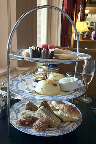
At 4 PM, we headed back to the Empress for tea. Despite our shabby appearance — I was wearing my usual henley t-shirt and jeans and Mike was similarly dressed — they sat us at a table by the window where we could look out at the harbor and watch the people go by. We started with a pair of champagne cocktails. Our waiter was excellent, recommending a tea that suited both of our tastes — I prefer mine without milk; Mike floods his with milk. Then he brought the customary three-tiered plate of goodies, including sandwiches, scones, and sweet treats. I’ve had afternoon tea about a half dozen times and this one was, by far, the best. Highly recommended.

Afterwards, we went back to Hemp & Company, a shop that sells clothes made of hemp and I bought two collared shirts to replace some linen shirts that were wearing thin. We also bought some maple cookies in a tourist shop for some friends of mine in Quincy and some candies from Roger’s Chocolates that turned out to be amazing.

We wandered back toward the ferry terminal. It was about 6:30 by then, but the ferry hadn’t arrived. There were a few horse-drawn carriages nearby and I hired one for a half-hour ride to the south side of the city. The weather was still clear and, when we reached the coast, we could clearly see the mountains of Washington’s Olympic Peninsula in the near distance. It was a nice, slow ride with a talkative young driver who told us a lot about historic buildings, including the limitations on repairs.

We got back to the terminal just in time to board the ferry. I photographed the city as the sun set, casting a golden light over the buildings and boats in the harbor.

Sunset over Victoria

The ride back was smooth. A waxing gibbous moon hung in the east when we disembarked in Port Angeles. We drove the truck back to the hotel and settled in for the night, exhausted by our long day of walking.