How some people try to make up — and enforce — FAA regulations.
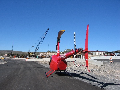
Yesterday, Mike and I flew out to Wenden to give helicopter rides to our friend, Celia, and her family. Wenden is a farming community primarily inhabited by Mexican farm workers. Its a tiny desert town in what must be a fertile valley. Wells pump water into irrigation canals and the entire area is surrounded by a patchwork of farm fields. This time of year, the cotton harvest is over and big square bins of cotton line one field after another. Most of the fields are already plowed and readied for their next harvest; a few are even planted.
A straight-line route between Wickenburg and Wenden takes me right over the top of an airpark called Eagle Roost. Eagle Roost was the brainchild of a man with vision. He bought a section of land — that’s a mile square — in Aguila, another Mexican farming community. He laid in a north-south runway, paved it, and sold 5-acre lots all around it. Back when I first started coming to this area about 10-12 years ago, the lots were going for $8,000 each and the place wasn’t very impressive. They’re now worth considerably more, and most lots have been built up.
Eagle Roost is the home of mostly retired people who are (or were) pilots. Like Wickenburg, half the population disappears during the hot summer months. Although the development isn’t bad, the town of Aguila has nothing much to offer. There are one or two small convenience stores, three restaurants, and a motel. Most people speak Spanish. On weekday mornings men gather in predetermined places, waiting to be picked for work crews. On Tuesdays (I think), there’s a farmers market. The place has terrible flies during cantaloupe harvest. There’s nothing much to do, so most Eagle Roost residents seem to do a lot of internal socializing, gossiping, and drinking. When they need something, they drive 25 miles east to Wickenburg or about 75 southeast to Phoenix’s west valley.
We used to have friends out there, but after a disagreement with one of them, another one told me he didn’t want to be friends with me anymore. (And no, he isn’t a third-grader.) No loss, as far as I’m concerned.
Anyway, whenever I fly from Wickenburg to points west, like Wenden, Salome, Vicksburg Junction, or Quartzsite, I usually fly right over the top of Eagle Roost. I’ve been doing it since I got my first helicopter, back in October 2000. More than five years now.
Don’t get me wrong — I don’t fly out there often. I don’t have reason to. There’s not much west of Wickenburg to fly to. As I mentioned elsewhere, Wickenburg is on the edge of nowhere. West of there is nowhere. But I definitely do it at least a few times a year. In fact, I did it a few weeks ago when I flew out to Quartzsite to research possible landing zones for a gig there.
Now in case you don’t know, helicopters fly lower than airplanes. In fact, there’s no set minimum altitude for helicopter flight. When I’m in Wickenburg, in or around town, I normally fly at 500-700 feet above the ground, but when I’m out in the desert, I sometimes fly lower. This is so for two reasons. The main reason is so I can see the stuff I’m flying over — range cattle, people off-roading out in the desert, the trickles of water in a spring-fed canyon creek. If I wanted to get from point A to point B without seeing what I was flying over, I’d fly an airplane. And that brings up the second reason I fly low: to avoid airplane traffic.
It’s a common joke among helicopter pilots. You mention that you flew at a certain higher-than-usual altitude someplace and a fellow helicopter pilot says, “Why the hell were you all the way up there? That’s where the planes are.”
We also joke about nosebleeds.
If you’ve been following along, you’ve probably guessed by now that I fly over Eagle Roost — and most other places I fly over — at less than 500 feet above the ground. I did it yesterday, on the way out to Wenden.
Now although very few of Eagle Roost’s residents are active pilots, there are a few who do actually own planes and fly them. So I treat Eagle Roost about the same as I treat Wickenburg. It’s a Class G, uncontrolled airport. Common courtesy — but not FAA regulations — dictates that you listen in on the airport frequency as you approach and depart the area and make one or more radio calls to announce your intentions and solicit responses from other pilots in the area. So, on the way west, I tuned into Eagle Roost’s frequency about six miles west of Wickenburg. I made a radio call as I passed south of Forepaugh, a historic airport that seems to have had its name wiped from aeronautical charts.
A minute or two later, I heard a call from someone at Eagle Roost departing runway 17 with a downwind departure. I had to translate that into direction. Helicopter pilots don’t have much use for runways so we don’t pay much attention to runway numbers and directions. It takes thought to decipher what the pilot had said. Since runway numbers correspond with compass directions, the pilot was taking off on the runway that pointed roughly south. Downwind was the direction parallel to the runway, but going in the opposite direction he’d taken off. That meant he was departing to the north. We were east and still pretty far out, so we were no factor. Mike and I actually discussed this thought process yesterday, comparing notes about how airplane and helicopter pilots think.
There were no more calls from Eagle Roost and no more traffic. I made a call three miles east, giving my altitude and intentions: transitioning to the west. Then I made another call when I was over the airpark. Then we were west, speeding along at a healthy 110 knots to our destination, still 25 or 30 miles west.
I circled the town of Wenden to find Celia’s street. She lives in a house between two farm fields, off Alamo Lake Road. I followed Alamo Lake Road with my eyes, saw her house, judged the wind from a flag, and decided to come in from the west. I lined up with an east-west road that ran right past her house. It was a farm road, made to give access to the fields. But it was Christmas Eve day and a Saturday, so the fields were empty. No one was using the road. I landed in a huge cloud of dust about 50 yards from her front door, where she and her family had gathered when they first heard us coming. The breeze from the east was pretty stiff, so the dust cloud swept past me when I idled down, so it didn’t actually reach where everyone was standing.
 I gave four rides, each with three people on board. It was Celia and her daughters and their husbands and kids. Mike handled the ground crew work. I gave short rides — there’s not much in Wenden to see — and everyone really seemed to enjoy it. I gave helicopter toys to the little kids. The dust was incredible on my takeoffs and landings and my fears were confirmed when I shut down in Wickenburg later on: a little more paint had been sanded off the blades.
When we were finished, Celia invited us in for burritos. But I had another charter at noon and wanted to get back to Wickenburg. So Celia gave Mike a package of burritos and he climbed on board. Soon we were on our way back to Wickenburg.
Of course, we flew over Eagle Roost again. We’d been on the same frequency since we’d left Wickenburg and there was no one talking on the radio. Mike and I kept an eye out for planes, as we usually do, and didn’t see any. I made my first radio call about 3 miles to the west and didn’t hear a thing from anyone in the area. But when I made my second call when I was overhead, the radio suddenly came to life.
“When you fly over the airport, fly above traffic pattern altitude,” came a man’s voice.
“Zero-Mike-Lima is a helicopter,” I told the person who’d called. “Helicopters fly below traffic pattern altitude.” No lie there.
“Helicopters have to follow the rules, too,” the voice said. If there hadn’t been an edge to it before, there was now.
“I’ll have to look that one up,” I replied.
“You do that.” Now definitely nasty. “The FAA would be interested.”
“Then I’ll ask the FAA,” I replied, thinking I might send my Part 135 contact at the Scottsdale FSDO an e-mail if I couldn’t find the rule. (Some people are afraid of the FAA. I’m not. All of my dealings with the FAA have been very fair and everyone I’ve worked with at the local FSDO has been very helpful and informative. So if this guy was trying to scare me, he wasn’t succeeding.)
By this time, I was about a mile or two to the east. The man, who Mike and I figured was on the ground because he didn’t provide an N-number, didn’t say anything else.
I looked at Mike. “Is there a rule like that?” I asked him.
“I don’t think so,” he replied.
“I’ll look it up,” I repeated. I have the 2006 FAR/AIM in my hangar. And we continued east, with the episode tucked in the back of our minds.
Unfortunately, that wasn’t the end of it. I was sitting with Mike and a few other pilots at a picnic table at Wickenburg airport, waiting for my noon charter and eating burritos when my cell phone rang. I looked down and saw a familiar phone number. When I answered it, I heard the voice of the Eagle Roost idiot who said he couldn’t be my friend all those years ago.
“I have absolutely no desire to talk to you,” I said. And I snapped the phone shut.
It started ringing again almost immediately. I pushed the button that would silence it. Then again. Sheesh! Some people just don’t get it. I turned the phone off.
We talked to the pilots we were with about the “rule” we’d been told about while over Eagle Roost. Mind you, we were sitting with three other active pilots — the kind that actually fly — and none of them had ever heard of such a rule for an airport in Class G airspace, let alone a private airpark that doesn’t even appear on current GPS maps.
I turned the phone on a while later and there were three messages on it. I let Mike listen to them. Two were from potential customers. The other was from the idiot at Eagle Roost. For some reason, this guy has become the “Godfather” of the airpark and everyone goes to him with their problems. And although the original cause of the breakup of our friendship years ago was because I hadn’t “minded my business” when his buddy was sleeping around behind my friend’s back, this guy has no problem minding other people’s business. He’d called to talk to me about flying over Eagle Roost. Supposedly, the guy who’d talked to me on the radio swore that there was another plane in the pattern. He claimed I was being dangerous and I’d been belligerent. And this former friend of mine had been assigned to talk to me about it. The hell with that.
One thing was already pretty obvious: the guy was lying about the plane, probably to cover up the fact that he didn’t know what he was talking about. I have four pieces of evidence to prove it:
- Neither Mike nor I, experienced, active pilots who were sitting in the front seat of an aircraft with virtually unlimited forward and side visibility, did not see another aircraft, even though we were both looking.
- No other pilot made a radio call. And yes, I do realize that the pilot could have been operating without a radio, but then who’s being safer: me with two radio calls or him with none?
- If the guy on the ground was so concerned about our altitude because of other traffic, why didn’t he mention the other traffic?
- How did the guy on the ground know there was other traffic if he was inside listening to his radio and the phantom pilot hadn’t made a call?
My charter passengers arrived right about the time Stan had the espresso machine fired up. I did two charters while everyone else went to Stan’s for a latte. By the time I was done an hour and a half later, Stan had closed up shop and most of the other pilots had gone home. I settled up with my passengers and locked up the helicopter on the ramp. I was schedule to fly Santa to a remote ranch at dawn on Christmas morning.
Mike said that the pilots gathered at Stan’s had discussed the “rule” at length. They all agreed that there was no such rule and that I hadn’t done anything wrong.
We had some repairs to make on our airport golf cart and Mike left to get the parts. While I was waiting, I washed the chicken dust off my car and spent about 20 minutes going through the FAR/AIM for the “rule.”
I found the helicopter altitude rule I’d already committed to memory: Helicopters may operate at an altitude lower than airplane minimum requirements as long as operations do not pose a danger to persons or property on the ground. This is paraphrased, of course — I don’t have the FARs in front of me right now. But this is the rule we’re taught and we discuss it at length. Although it seems like it’s a free pass to fly wherever you want, if something does happen and you have an emergency landing and someone on the ground gets hurt, the FAA could always say that you were not operating at a safe altitude. So safety is always the primary concern when choosing a minimum altitude. For a helicopter, that means operating within the safe area of the height-velocity diagram, a document that establishes safe altitude and airspeed combinations to make a power-off landing. Of course, terrain has a lot to do with it, too. There needs to be a flat open space within range to land. Like a farm field? Or a runway at an airpark? So as far as that rule was concerned, I was operating at a safe altitude.
I also found another helicopter rule that was pounded into my head when training: helicopters are to avoid the flow of fixed wing traffic. This is the rule that keeps helicopters low. In fact, whenever I operate in a Class D airspace — that’s an airport with a control tower —-and I want to approach my landing zone or cross over the top, I’m directed to stay below the traffic pattern altitude. Even when crossing over the top — and I can’t tell you how many times I crossed over the top of Scottsdale while working on on my private helicopter rating. Just the other day, when leaving Scottsdale Airport, the tower cleared me to depart and directed me to remain below 2,000 feet — or below the traffic pattern altitude. I come and go at Prescott below the TPA and, when I was training at Grand Canyon Airport to work for Papillon, I was constantly reminded by my instructor to stay below 7,000 feet MSL — below the traffic pattern altitude. (Of course, that put me right over the treetops, which wasn’t a comfortable place to be, at first.) As a result of all this work in Class D airspace, it’s become natural for me to cross airports below the traffic pattern altitude. I never expected to be told that there was a rule to the contrary.
I looked for, but did not find, any rule stating required — or even recommended — altitudes for any kind of aircraft operating in the vicinity of a Class G airport. So what the hell was this guy talking about?
I reported my findings to Mike as he worked on the golf cart. We went home, stopping at Safeway for some wine to take to Christmas dinner at a friend’s house the next day.
Belligerent. That word bothered me. I asked Mike if I’d been belligerent on the radio. He said I hadn’t but the guy who’d talked to me had definitely been belligerent. So I asked Mike to call the idiot at Eagle Roost and tell him I wasn’t belligerent.
Mistake. The guy talked poor Mike’s ear off. And, as usual, he didn’t believe anything Mike had to say. Talk about a trap door mind. One of his neighbors had sworn something to him, and the idiot, our former friend, was willing to believe him instead of us. Radio man said that a plane had been in the pattern and I had been belligerent. Period, end of story, trap door swings shut. Poor Mike listened to the idiot far longer than I would have. I felt bad for him when he finally hung up.
Like I said, no loss.
Tomorrow, I’ll give my FAA contact a call and ask him about this “rule.” He’s a helicopter guy, so he’ll know. And if there is no rule, I’ll just pretend the whole thing never happened.
PostScript
I called my POI at the Scottsdale FSDO and talked to him. Twice. He confirmed what I suspected: there is no rule in the FARs specifying an altitude for untowered airport overflights. That applies to both airplanes and helicopters. However, he added in his best FAA voice, a “prudent pilot” would overfly above the traffic pattern altitude. He went on to provide some examples of how overflight at a lower altitude could cause problems.
So I was right but I was wrong. And so was the guy on the ground.
In my opinion, if something happens while you’re flying in Class G airspace — like a midair collision or even a near miss or a forced go-around — then one of the pilots (at least) is not being prudent. It doesn’t matter what the situtation was: if a rule wasn’t broken but someone did something dumb that caused a problem, that someone wasn’t being prudent. But if nothing happens? Then is there a question of what’s prudent? I don’t know. But I do think that if the FAA felt strongly about altitudes at Class G airports, it should amend the regulations to specify an altitude. That would turn a gray area into black and white. What good are regulations if you can’t use them to guide you in your actions?
I also spoke to a fellow helicopter pilot who lives in the area. “Do you ever fly over Eagle Roost?” I asked.
“Once in a while,” he replied.
“What altitude?”
“Usually about 400 feet.”
So I wasn’t the only one. “Do you talk on the radio?” I asked.
“No.”
He didn’t add what we both knew: The regulations do not require communication in Class G airspace. But who’s being more safe? The pilot who attempts communication or the one who just buzzes through without a peep?
What is the lesson to be learned from this? It isn’t one the FAA would like.
The lesson is that when you overfly an airport without a published radio frequency, don’t talk on the radio. Eagle Roost’s frequency does not appear on any chart and the airport is not listed in the Airport/Facilities Directory, the only two documents a pilot is required to have onboard (and I’m not even sure the A/FD is required for all pilots, although it is required for Part 135 operations). If I hadn’t responsibly made my radio calls, the guy on the ground wouldn’t have even known I was flying over. He’d have nothing to get his blood pressure up. He wouldn’t have called the idiot to harass me. None of this would have happened. Heck, you wouldn’t even be reading a blog entry about it.
Fortunately, that’s not the lesson I learned. I learned that residents at private airparks are a bunch of whiners who like to boss around anyone within radio range. They like to make up stories about possible accidents and share them with anyone who will listen and take their words as gospel truth. And some of them even like to take it beyond the radio, with harassment by phone and in person.
As for me, I won’t overfly Eagle Roost again. It just isn’t worth the headaches that go with it.

 So on December 30, at 12:30 PM, I arrived at Stanton as scheduled and landed on a seldom-used road near the campground. My ground crew — Mike, John, and Lorna — got out and set up a little table. I shut down and waited for the crowd to gather. They came in pairs and trios and when I had at least 4 people waiting, I started up again. Lorna took the money — $30, including tax, per person. Mike and John gave the safety briefings and loaded up the passengers. Then I took off toward Wickenburg, climbing, climbing, climbing. I rounded the south end of Rich Hill and climbed up its east side. The passengers had excellent views of what was left of Octave and the mining activity going on in that canyon. Finally, 2000 feet above Stantons’ elevation, I rounded the north end of Rich Hill, still climbing. We were over the next valley, with Stanton far below us in the mouth of the canyon. I pointed out the Potato Patch and the miner types oohed and aahed. I started the descent, coming down at a rate of more than 1,000 feet per minute. On the way down, I pointed out Wickenburg, far to the south, and Congress, to the west. Also, North Ranch (which, you may recall, the management claims occupants are too old for helicopter rides) and the dairy farm. Even at a 1,200 feet per minute descent rate, I can’t get to Stanton without overflying it and turning back, making an elongated spiral to my landing zone.
 I flew for a few hours, taking a break for lunch before starting up again and flying some more. The route started from our desert clearing, which was just big enough for Zero-Mike-Lima to fit comfortably, to the east alongside the base of the mountain behind Robson’s. I climbed as I flew, pointing out where Wickenburg would be if we could see it (we couldn’t), Vulture Peak, Congress, and Alamo Lake if we could see it (we couldn’t). Then I came along the back side of the mountain, crossing over a saddle on the west side. (There were a couple of guys and a dog working an old mine shaft up there and I wonder what they think of the helicopter flying over them every 10 to 12 minutes or so.) I came through the canyon where Robson’s is nestled, pointing out the trail to the petroglyphs along the way. I flew jsut to the east of town, where everyone could see me but not be bothered by the sound of the helicopter, before circling around to land back in my LZ.
 I gave four rides, each with three people on board. It was Celia and her daughters and their husbands and kids. Mike handled the ground crew work. I gave short rides — there’s not much in Wenden to see — and everyone really seemed to enjoy it. I gave helicopter toys to the little kids. The dust was incredible on my takeoffs and landings and my fears were confirmed when I shut down in Wickenburg later on: a little more paint had been sanded off the blades.